Bridge Statistics for Hayden, Alabama (AL)
Condition, Traffic, Stress, Structural Evaluation, Project Costs
- National Bridge Inventory (NBI) Statistics
- 29Number of bridges
- 279ft / 85.4mTotal length
- $30,661,000Total costs
- 144,222Total average daily traffic
- 27,167Total average daily truck traffic
- National Bridge Inventory (NBI) Registered Bridges for Hayden
- No street view available for this location
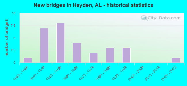
- New bridges - historical statistics
- 11930-1939
- 71940-1949
- 81950-1959
- 41960-1969
- 21970-1979
- 31980-1989
- 31990-1999
- 12020-2022


- Bridge Condition - Deck
- 8.3%Excellent
- 50.0%Good
- 16.7%Satisfactory
- 25.0%Fair

- Bridge Condition - Superstructure
- 8.3%Excellent
- 8.3%Very good
- 41.7%Good
- 25.0%Satisfactory
- 16.7%Fair

- Bridge Condition - Substructure
- 8.3%Excellent
- 8.3%Very good
- 8.3%Good
- 58.3%Satisfactory
- 16.7%Fair

- Bridge Condition - Channel
- 8.3%Good
- 50.0%Satisfactory
- 41.7%Fair

- Bridge Condition - Culverts
- 53.3%Satisfactory
- 40.0%Fair
- 6.7%Poor
Find on map >> Show street view
Structure Number: 2311, Location: .9 MI. N. OF BOYD (Lat: 32.631183, Lng: -88.303492), Route carried "on" structure: State highway 17, Year Built: 1940, Status: Open, Structure Length: 4.22m (13.85ft), Average Daily Traffic: 926 (year 2020), Truck Traffic: 25%, Average Future Daily Traffic: 1,517 (year 2039), Design Load: H 15, Features Intersected: UT SANUSI CREEK
Minimum Vertical Clearance: 30+ m (98+ ft), Kilometerpoint: 241.814, Lanes on structure: 2, Owner: State Highway Agency, Approaching Roadway Width: 10.1m (33.1ft), Skew: 4 degrees, Material/Design: Concrete, Design/Construction: Culvert, Number Of Spans In Main Unit: 15, Length of Maximum Span: 1.8m (5.9ft), Curb-To-Curb Width: 9.1m (29.9ft), Out-to-Out Width: 9.2m (30.2ft)
Condition: Channel: Satisfactory, Culverts: Satisfactory, Operating Rating: 52.0 metric tons, Method Used To Determine Operating Rating: Load Factor (LF), Inventory Rating: 32.5 metric tons, Method Used To Determine Inventory Rating: Load Factor (LF), Structural Evaluation: Equal to present minimum criteria, Deck Geometry: Equal to present minimum criteria, Waterway Adequacy: Better than present minimum criteria, Approach Roadway Alignment: Equal to present minimum criteria, Length Of Structure Improvement: 5.19m (17.03ft), Designated Inspection Frequency: Every 24 months, Inspection Date: Febuary 2021, Bridge Improvement Cost: $1,350,000, Roadway Improvement Cost: $135,000, Total Project Cost: $1,485,000 ( Estimate for 2022)
Find on map >> Show street view
Structure Number: 2644, Location: 3.5 MI.NO. I-65 (Lat: 33.923889, Lng: -86.807222), Route carried "on" structure: US 31, Year Built: 1942, Status: Open, Structure Length: 8.63m (28.31ft), Average Daily Traffic: 2,400 (year 2021), Truck Traffic: 9%, Average Future Daily Traffic: 3,083 (year 2041), Design Load: HS 20, Features Intersected: MURPHY CREEK
Minimum Vertical Clearance: 30+ m (98+ ft), Kilometerpoint: 493.039, Lanes on structure: 2, Owner: State Highway Agency, Approaching Roadway Width: 8.5m (27.9ft), Skew: 3 degrees, Material/Design: Concrete, Design/Construction: Tee Beam, Number Of Spans In Main Unit: 8, Length of Maximum Span: 10.4m (34.1ft), Curb-To-Curb Width: 8.5m (27.9ft), Out-to-Out Width: 10.1m (33.1ft)
Condition: Deck: Fair, Superstructure: Satisfactory, Substructure: Satisfactory, Channel: Good, Operating Rating: 38.7 metric tons, Method Used To Determine Operating Rating: Load Factor (LF), Inventory Rating: 23.3 metric tons, Method Used To Determine Inventory Rating: Load Factor (LF), Structural Evaluation: Equal to present minimum criteria, Deck Geometry: Meets minimum limits, Waterway Adequacy: Superior to present desirable criteria, Approach Roadway Alignment: Somewhat better than minimum adequacy, Length Of Structure Improvement: 9.61m (31.53ft), Designated Inspection Frequency: Every 24 months, Inspection Date: June 2021, Bridge Improvement Cost: $2,175,000, Roadway Improvement Cost: $218,000, Total Project Cost: $2,393,000 ( Estimate for 2022), Deck Structure Type: Concrete Cast-file-Place, Wearing Surface/Protective System: Wearing Surface: Bituminous
Find on map >> Show street view
Structure Number: 2645, Location: .6 MI.NO.CO RD 7 (Lat: 33.938889, Lng: -86.786667), Route carried "on" structure: US 31, Year Built: 1942, Status: Open, Structure Length: 1.37m (4.49ft), Average Daily Traffic: 2,925 (year 2020), Truck Traffic: 9%, Average Future Daily Traffic: 4,791 (year 2040), Features Intersected: BRANCH
Minimum Vertical Clearance: 30+ m (98+ ft), Kilometerpoint: 495.504, Lanes on structure: 2, Owner: State Highway Agency, Approaching Roadway Width: 10.4m (34.1ft), Skew: 4 degrees, Material/Design: Concrete, Design/Construction: Culvert, Number Of Spans In Main Unit: 3, Length of Maximum Span: 3.0m (9.8ft)
Condition: Channel: Fair, Culverts: Satisfactory, Operating Rating: 88.9 metric tons, Method Used To Determine Operating Rating: Load Factor (LF), Inventory Rating: 88.9 metric tons, Method Used To Determine Inventory Rating: Load Factor (LF), Structural Evaluation: Equal to present minimum criteria, Waterway Adequacy: Somewhat better than minimum adequacy, Approach Roadway Alignment: Equal to present desirable criteria, Length Of Structure Improvement: 2.04m (6.69ft), Designated Inspection Frequency: Every 24 months, Inspection Date: July 2020, Bridge Improvement Cost: $1,380,000, Roadway Improvement Cost: $138,000, Total Project Cost: $1,518,000 ( Estimate for 2022), Wearing Surface/Protective System: Wearing Surface: Bituminous
Find on map >> Show street view
Structure Number: 3137, Location: 1.2 MI. NO. I-65 (Lat: 33.857500, Lng: -86.803056), Route carried "on" structure: State highway 160, Year Built: 1947, Status: Open, Structure Length: 0.76m (2.49ft), Average Daily Traffic: 11,434 (year 2021), Truck Traffic: 8%, Average Future Daily Traffic: 13,721 (year 2041), Design Load: H 15, Features Intersected: DOUBLE BRANCH
Minimum Vertical Clearance: 30+ m (98+ ft), Kilometerpoint: 2.033, Lanes on structure: 2, Owner: State Highway Agency, Approaching Roadway Width: 8.5m (27.9ft), Skew: 4 degrees, Material/Design: Steel, Design/Construction: Culvert, Number Of Spans In Main Unit: 1, Length of Maximum Span: 7.6m (24.9ft)
Condition: Channel: Satisfactory, Culverts: Satisfactory, Operating Rating: 34.9 metric tons, Method Used To Determine Operating Rating: Load Factor (LF), Inventory Rating: 28.0 metric tons, Method Used To Determine Inventory Rating: Load Factor (LF), Structural Evaluation: Equal to present minimum criteria, Waterway Adequacy: Equal to present desirable criteria, Approach Roadway Alignment: Equal to present desirable criteria, Length Of Structure Improvement: 1.41m (4.63ft), Designated Inspection Frequency: Every 24 months, Inspection Date: January 2021, Bridge Improvement Cost: $367,000, Roadway Improvement Cost: $37,000, Total Project Cost: $404,000 ( Estimate for 2022), Wearing Surface/Protective System: Wearing Surface: Bituminous
Find on map >> Show street view
Structure Number: 3499, Location: @ CULLWELL RD (Lat: 33.905278, Lng: -86.731389), Route carried "on" structure: State highway 160, Year Built: 1949, Status: Open, Structure Length: 1.31m (4.30ft), Average Daily Traffic: 7,910 (year 2021), Truck Traffic: 9%, Average Future Daily Traffic: 9,295 (year 2041), Design Load: H 15, Features Intersected: HAYES CK
Minimum Vertical Clearance: 30+ m (98+ ft), Kilometerpoint: 10.900, Lanes on structure: 2, Owner: State Highway Agency, Approaching Roadway Width: 7.3m (24.0ft), Material/Design: Concrete, Design/Construction: Culvert, Number Of Spans In Main Unit: 4, Length of Maximum Span: 3.0m (9.8ft)
Condition: Channel: Satisfactory, Culverts: Satisfactory, Operating Rating: 55.6 metric tons, Method Used To Determine Operating Rating: Load Factor (LF), Inventory Rating: 33.4 metric tons, Method Used To Determine Inventory Rating: Load Factor (LF), Structural Evaluation: Equal to present minimum criteria, Waterway Adequacy: Equal to present minimum criteria, Approach Roadway Alignment: Equal to present desirable criteria, Length Of Structure Improvement: 1.98m (6.50ft), Designated Inspection Frequency: Every 24 months, Inspection Date: January 2021, Bridge Improvement Cost: $344,000, Roadway Improvement Cost: $34,000, Total Project Cost: $378,000 ( Estimate for 2022), Wearing Surface/Protective System: Wearing Surface: Bituminous
Find on map >> Show street view
Structure Number: 35, Location: .1 MI. SO.CO.RD.45 (Lat: 33.938333, Lng: -86.682222), Route carried "on" structure: State highway 160, Year Built: 1949, Status: Open, Structure Length: 1.34m (4.40ft), Average Daily Traffic: 4,340 (year 2021), Truck Traffic: 16%, Average Future Daily Traffic: 5,100 (year 2041), Design Load: H 15, Features Intersected: SUGAR CREEK
Minimum Vertical Clearance: 30+ m (98+ ft), Kilometerpoint: 17.230, Lanes on structure: 2, Owner: State Highway Agency, Approaching Roadway Width: 7.9m (25.9ft), Material/Design: Concrete, Design/Construction: Culvert, Number Of Spans In Main Unit: 4, Length of Maximum Span: 3.0m (9.8ft)
Condition: Channel: Satisfactory, Culverts: Satisfactory, Operating Rating: 64.5 metric tons, Method Used To Determine Operating Rating: Load Factor (LF), Inventory Rating: 38.6 metric tons, Method Used To Determine Inventory Rating: Load Factor (LF), Structural Evaluation: Equal to present minimum criteria, Waterway Adequacy: Equal to present minimum criteria, Approach Roadway Alignment: Equal to present desirable criteria, Length Of Structure Improvement: 2.02m (6.63ft), Designated Inspection Frequency: Every 24 months, Inspection Date: March 2021, Bridge Improvement Cost: $407,000, Roadway Improvement Cost: $41,000, Total Project Cost: $448,000 ( Estimate for 2022), Wearing Surface/Protective System: Wearing Surface: Bituminous
Find on map >> Show street view
Structure Number: 3501, Location: @ CO. RD. 13 (Lat: 33.947500, Lng: -86.669722), Route carried "on" structure: State highway 160, Year Built: 1949, Status: Open, Structure Length: 1.01m (3.31ft), Average Daily Traffic: 3,520 (year 2021), Truck Traffic: 5%, Average Future Daily Traffic: 4,136 (year 2041), Design Load: H 15, Features Intersected: SHOAL CREEK
Minimum Vertical Clearance: 30+ m (98+ ft), Kilometerpoint: 18.709, Lanes on structure: 2, Owner: State Highway Agency, Approaching Roadway Width: 7.9m (25.9ft), Skew: 3 degrees, Material/Design: Concrete, Design/Construction: Culvert, Number Of Spans In Main Unit: 3, Length of Maximum Span: 3.0m (9.8ft)
Condition: Channel: Good, Culverts: Satisfactory, Operating Rating: 70.3 metric tons, Method Used To Determine Operating Rating: Load Factor (LF), Inventory Rating: 42.2 metric tons, Method Used To Determine Inventory Rating: Load Factor (LF), Structural Evaluation: Equal to present minimum criteria, Waterway Adequacy: Equal to present minimum criteria, Approach Roadway Alignment: Equal to present desirable criteria, Length Of Structure Improvement: 1.68m (5.51ft), Designated Inspection Frequency: Every 24 months, Inspection Date: April 2021, Bridge Improvement Cost: $397,000, Roadway Improvement Cost: $40,000, Total Project Cost: $437,000 ( Estimate for 2022), Wearing Surface/Protective System: Wearing Surface: Bituminous
Find on map >> Show street view
Structure Number: 3889, Location: AL 160 * PANNEL CK (Lat: 33.916667, Lng: -86.710278), Route carried "on" structure: State highway 160, Year Built: 1950, Status: Open, Structure Length: 0.69m (2.26ft), Average Daily Traffic: 4,441 (year 2021), Truck Traffic: 16%, Average Future Daily Traffic: 7,282 (year 2041), Design Load: H 15, Features Intersected: PANNEL CREEK
Minimum Vertical Clearance: 30+ m (98+ ft), Kilometerpoint: 13.477, Lanes on structure: 2, Owner: State Highway Agency, Approaching Roadway Width: 7.9m (25.9ft), Material/Design: Concrete, Design/Construction: Culvert, Number Of Spans In Main Unit: 2, Length of Maximum Span: 3.0m (9.8ft)
Condition: Channel: Fair, Culverts: Poor, Operating Rating: 88.9 metric tons, Method Used To Determine Operating Rating: Load Factor (LF), Inventory Rating: 88.9 metric tons, Method Used To Determine Inventory Rating: Load Factor (LF), Structural Evaluation: Meets minimum limits, Waterway Adequacy: Better than present minimum criteria, Approach Roadway Alignment: Equal to present desirable criteria, Length Of Structure Improvement: 1.32m (4.33ft), Designated Inspection Frequency: Every 24 months, Other Special Inspection Frequency: Every 12 months, Inspection Date: June 2021, Other Special Inspection Date: June 2021, Bridge Improvement Cost: $748,000, Roadway Improvement Cost: $75,000, Total Project Cost: $823,000 ( Estimate for 2022), Wearing Surface/Protective System: Wearing Surface: Bituminous
Find on map >> Show street view
Structure Number: 3947, Location: 2 MI S OF CORNER (Lat: 33.782500, Lng: -86.940833), Route carried "on" structure: County highway 602, Year Built: 1950, Status: Open, Structure Length: 0.69m (2.26ft), Average Daily Traffic: 2,580 (year 2021), Truck Traffic: 5%, Average Future Daily Traffic: 3,300 (year 2041), Features Intersected: WARD CREEK TRIBUTARY, Facility Carried by Structure: CORNER SCHOOL RD
Minimum Vertical Clearance: 30+ m (98+ ft), Kilometerpoint: 0.010, Lanes on structure: 2, Owner: County Highway Agency, Approaching Roadway Width: 6.6m (21.7ft), Skew: 3 degrees, Material/Design: Concrete, Design/Construction: Slab, Number Of Spans In Main Unit: 1, Length of Maximum Span: 5.2m (17.1ft), Curb or Sidewalk Widths: Left: 0.3m (1.0ft), Right: 0.3m (1.0ft), Curb-To-Curb Width: 9.4m (30.8ft), Out-to-Out Width: 10.1m (33.1ft)
Condition: Deck: Good, Superstructure: Good, Substructure: Satisfactory, Channel: Fair, Operating Rating: 32.7 metric tons, Method Used To Determine Operating Rating: Field evaluation and documented engineering judgment, Inventory Rating: 24.5 metric tons, Method Used To Determine Inventory Rating: Field evaluation and documented engineering judgment, Structural Evaluation: Equal to present minimum criteria, Deck Geometry: Meets minimum limits, Waterway Adequacy: Equal to present minimum criteria, Approach Roadway Alignment: Better than present minimum criteria, Length Of Structure Improvement: 1.33m (4.36ft), Designated Inspection Frequency: Every 24 months, Inspection Date: November 2021, Bridge Improvement Cost: $302,000, Roadway Improvement Cost: $30,000, Total Project Cost: $332,000 ( Estimate for 2022), Deck Structure Type: Concrete Cast-file-Place, Wearing Surface/Protective System: Wearing Surface: Bituminous
Find on map >> Show street view
Structure Number: 5681, Location: 1 MI W OF BLOUNT SPRINGS (Lat: 33.928114, Lng: -86.810128), Route carried "on" structure: County highway 400, Year Built: 1956, Status: Open, Structure Length: 1.46m (4.79ft), Average Daily Traffic: 670 (year 2020), Truck Traffic: 10%, Average Future Daily Traffic: 996 (year 2040), Design Load: H 15, Features Intersected: MILL CREEK, Facility Carried by Structure: BLOUNT CO NO 5
Minimum Vertical Clearance: 30+ m (98+ ft), Kilometerpoint: 0.010, Lanes on structure: 2, Owner: County Highway Agency, Approaching Roadway Width: 8.8m (28.9ft), Skew: 4 degrees, Material/Design: Concrete, Design/Construction: Culvert, Number Of Spans In Main Unit: 3, Length of Maximum Span: 4.9m (16.1ft)
Condition: Channel: Satisfactory, Culverts: Fair, Operating Rating: 77.5 metric tons, Method Used To Determine Operating Rating: Load Factor (LF), Inventory Rating: 46.4 metric tons, Method Used To Determine Inventory Rating: Load Factor (LF), Structural Evaluation: Somewhat better than minimum adequacy, Waterway Adequacy: Equal to present minimum criteria, Approach Roadway Alignment: Better than present minimum criteria, Length Of Structure Improvement: 2.14m (7.02ft), Designated Inspection Frequency: Every 24 months, Inspection Date: November 2020, Bridge Improvement Cost: $791,000, Roadway Improvement Cost: $79,000, Total Project Cost: $870,000 ( Estimate for 2022)
Find on map >> Show street view
Structure Number: 5682, Location: 3 MI SW OF BLOUNT SPRINGS (Lat: 33.915222, Lng: -86.851892), Route carried "on" structure: County highway 400, Year Built: 1956, Status: Open, Structure Length: 0.61m (2.00ft), Average Daily Traffic: 621 (year 2020), Truck Traffic: 10%, Average Future Daily Traffic: 923 (year 2040), Design Load: H 15, Features Intersected: JAMES CREEK, Facility Carried by Structure: BLOUNT CO NO 5
Minimum Vertical Clearance: 30+ m (98+ ft), Kilometerpoint: 0.000, Lanes on structure: 2, Owner: County Highway Agency, Approaching Roadway Width: 8.5m (27.9ft), Material/Design: Concrete, Design/Construction: Culvert, Number Of Spans In Main Unit: 2, Length of Maximum Span: 3.0m (9.8ft)
Condition: Channel: Fair, Culverts: Satisfactory, Operating Rating: 34.6 metric tons, Method Used To Determine Operating Rating: Load Factor (LF), Inventory Rating: 20.7 metric tons, Method Used To Determine Inventory Rating: Load Factor (LF), Structural Evaluation: Somewhat better than minimum adequacy, Waterway Adequacy: Equal to present minimum criteria, Approach Roadway Alignment: Equal to present desirable criteria, Length Of Structure Improvement: 1.22m (4.00ft), Designated Inspection Frequency: Every 24 months, Inspection Date: November 2020, Bridge Improvement Cost: $275,000, Roadway Improvement Cost: $28,000, Total Project Cost: $303,000 ( Estimate for 2022)
Find on map >> Show street view
Structure Number: 5683, Location: 1 MI SW OF BLOUNT SPRINGS (Lat: 33.925125, Lng: -86.806283), Route carried "on" structure: County highway 400, Year Built: 1956, Status: Open, Structure Length: 0.61m (2.00ft), Average Daily Traffic: 670 (year 2020), Truck Traffic: 10%, Average Future Daily Traffic: 996 (year 2040), Design Load: H 15, Features Intersected: MILL CREEK, Facility Carried by Structure: BLOUNT CO NO 5
Minimum Vertical Clearance: 30+ m (98+ ft), Kilometerpoint: 0.100, Lanes on structure: 2, Owner: County Highway Agency, Approaching Roadway Width: 9.8m (32.2ft), Skew: 3 degrees, Material/Design: Concrete, Design/Construction: Culvert, Number Of Spans In Main Unit: 2, Length of Maximum Span: 3.0m (9.8ft)
Condition: Channel: Satisfactory, Culverts: Fair, Operating Rating: 88.9 metric tons, Method Used To Determine Operating Rating: Load Factor (LF), Inventory Rating: 88.9 metric tons, Method Used To Determine Inventory Rating: Load Factor (LF), Structural Evaluation: Somewhat better than minimum adequacy, Waterway Adequacy: Somewhat better than minimum adequacy, Approach Roadway Alignment: Better than present minimum criteria, Length Of Structure Improvement: 1.22m (4.00ft), Designated Inspection Frequency: Every 24 months, Inspection Date: November 2020, Bridge Improvement Cost: $451,000, Roadway Improvement Cost: $45,000, Total Project Cost: $496,000 ( Estimate for 2022)
Find on map >> Show street view
Structure Number: 6448, Location: 0.4 MI S CO RD 5 (Lat: 33.906111, Lng: -86.863333), Route carried "on" structure: Interstate 65, Year Built: 1959, Status: Open, Structure Length: 1.28m (4.20ft), Average Daily Traffic: 44,547 (year 2020), Truck Traffic: 26%, Average Future Daily Traffic: 88,645 (year 2040), Design Load: HS 20, Features Intersected: BRANCH
Minimum Vertical Clearance: 30+ m (98+ ft), Kilometerpoint: 465.017, Lanes on structure: 4, Base Highway Network: Yes, Owner: State Highway Agency, Approaching Roadway Width: 24.4m (80.1ft), Skew: 10 degrees, Material/Design: Concrete, Design/Construction: Culvert, Number Of Spans In Main Unit: 4, Length of Maximum Span: 3.0m (9.8ft)
Condition: Channel: Fair, Culverts: Fair, Operating Rating: 88.9 metric tons, Method Used To Determine Operating Rating: Load Factor (LF), Inventory Rating: 88.9 metric tons, Method Used To Determine Inventory Rating: Load Factor (LF), Structural Evaluation: Somewhat better than minimum adequacy, Waterway Adequacy: Equal to present desirable criteria, Approach Roadway Alignment: Equal to present desirable criteria, Length Of Structure Improvement: 1.95m (6.40ft), Designated Inspection Frequency: Every 24 months, Inspection Date: May 2020, Bridge Improvement Cost: $3,068,000, Roadway Improvement Cost: $307,000, Total Project Cost: $3,375,000 ( Estimate for 2022)
Find on map >> Show street view
Structure Number: 6449, Location: I65 * CO RD 5 (Lat: 33.911536, Lng: -86.865117), Route carried "on" structure: County highway , Year Built: 1959, Status: Open, Structure Length: 7.50m (24.61ft), Average Daily Traffic: 1,674 (year 2020), Truck Traffic: 1%, Average Future Daily Traffic: 1,768 (year 2040), Design Load: HS 20, Features Intersected: I-65, Facility Carried by Structure: CO ROAD 5
Minimum Vertical Clearance: 30+ m (98+ ft), Kilometerpoint: 0.010, Lanes on structure: 2, Lanes under structure: 6, Owner: State Highway Agency, Approaching Roadway Width: 9.8m (32.2ft), Skew: 1 degrees, Material/Design: Concrete continuous, Design/Construction: Tee Beam, Number Of Spans In Main Unit: 4, Length of Maximum Span: 20.7m (67.9ft), Curb-To-Curb Width: 8.5m (27.9ft), Out-to-Out Width: 9.4m (30.8ft)
Condition: Deck: Satisfactory, Superstructure: Satisfactory, Substructure: Satisfactory, Operating Rating: 47.5 metric tons, Method Used To Determine Operating Rating: Load Factor (LF), Inventory Rating: 28.5 metric tons, Method Used To Determine Inventory Rating: Load Factor (LF), Structural Evaluation: Equal to present minimum criteria, Deck Geometry: Somewhat better than minimum adequacy, Underclear: High priority of corrective action, Approach Roadway Alignment: Equal to present minimum criteria, Length Of Structure Improvement: 8.52m (27.95ft), Designated Inspection Frequency: Every 24 months, Inspection Date: July 2020, Bridge Improvement Cost: $1,811,000, Roadway Improvement Cost: $181,000, Total Project Cost: $1,992,000 ( Estimate for 2022), Deck Structure Type: Concrete Cast-file-Place
Find on map >> Show street view
Structure Number: 7672, Location: CR 35 (Lat: 33.871872, Lng: -86.923556), Route carried "on" structure: County highway 17, Year Built: 1962, Status: Posted for load, Structure Length: 12.28m (40.29ft), Average Daily Traffic: 550 (year 1991), Truck Traffic: 15%, Average Future Daily Traffic: 630 (year 2035), Design Load: H 15, Features Intersected: MULBERRY FORK, Facility Carried by Structure: CO. RT. 35
Minimum Vertical Clearance: 30+ m (98+ ft), Kilometerpoint: 0.010, Lanes on structure: 2, Owner: County Highway Agency, Approaching Roadway Width: 7.3m (24.0ft), Material/Design: Steel continuous, Design/Construction: Stringer/Multi-beam, Number Of Spans In Main Unit: 3, Number Of Approach Spans: 4, Length of Maximum Span: 30.5m (100.1ft), Curb-To-Curb Width: 6.7m (22.0ft), Out-to-Out Width: 7.3m (24.0ft)
Condition: Deck: Good, Superstructure: Good, Substructure: Good, Channel: Satisfactory, Operating Rating: 35.7 metric tons, Method Used To Determine Operating Rating: Load Factor (LF), Inventory Rating: 21.4 metric tons, Method Used To Determine Inventory Rating: Load Factor (LF), Structural Evaluation: Somewhat better than minimum adequacy, Deck Geometry: Meets minimum limits, Waterway Adequacy: Better than present minimum criteria, Approach Roadway Alignment: Equal to present minimum criteria, Bridge Posting: Required (Relationship of Operating Rating to Maximum Legal Load: 0.1 - 9.9% below), Length Of Structure Improvement: 13.13m (43.08ft), Designated Inspection Frequency: Every 24 months, Other Special Inspection Frequency: Every 12 months, Inspection Date: March 2021, Other Special Inspection Date: March 2021, Bridge Improvement Cost: $2,160,000, Roadway Improvement Cost: $216,000, Total Project Cost: $2,376,000 ( Estimate for 2022), Deck Structure Type: Concrete Cast-file-Place
Find on map >> Show street view
Structure Number: 9468, Location: 1 1/2 MI N OF SLOAN (Lat: 33.864208, Lng: -86.932644), Route carried "on" structure: County highway 400, Year Built: 1967, Status: Open, Structure Length: 0.85m (2.79ft), Average Daily Traffic: 621 (year 2020), Truck Traffic: 10%, Average Future Daily Traffic: 923 (year 2040), Design Load: H 20, Features Intersected: PRICE CREEK, Facility Carried by Structure: BLOUNT NO 5
Minimum Vertical Clearance: 30+ m (98+ ft), Kilometerpoint: 0.010, Lanes on structure: 2, Owner: County Highway Agency, Approaching Roadway Width: 8.5m (27.9ft), Skew: 4 degrees, Material/Design: Concrete, Design/Construction: Culvert, Number Of Spans In Main Unit: 2, Length of Maximum Span: 4.3m (14.1ft)
Condition: Channel: Fair, Culverts: Fair, Operating Rating: 88.9 metric tons, Method Used To Determine Operating Rating: Load Factor (LF), Inventory Rating: 88.9 metric tons, Method Used To Determine Inventory Rating: Load Factor (LF), Structural Evaluation: Somewhat better than minimum adequacy, Waterway Adequacy: Equal to present minimum criteria, Approach Roadway Alignment: Somewhat better than minimum adequacy, Length Of Structure Improvement: 1.52m (4.99ft), Designated Inspection Frequency: Every 24 months, Inspection Date: November 2020, Bridge Improvement Cost: $1,000,000, Roadway Improvement Cost: $100,000, Total Project Cost: $1,100,000 ( Estimate for 2022)
Find on map >> Show street view
Structure Number: 947, Location: 1 MI N OF RED HILL (Lat: 33.877719, Lng: -86.908867), Route carried "on" structure: County highway 400, Year Built: 1967, Status: Open, Structure Length: 0.61m (2.00ft), Average Daily Traffic: 640 (year 2020), Truck Traffic: 10%, Average Future Daily Traffic: 951 (year 2040), Design Load: H 15, Features Intersected: ISABELLE CREEK, Facility Carried by Structure: COUNTY ROAD 5
Minimum Vertical Clearance: 30+ m (98+ ft), Kilometerpoint: 0.010, Lanes on structure: 2, Owner: County Highway Agency, Approaching Roadway Width: 11.3m (37.1ft), Skew: 4 degrees, Material/Design: Concrete, Design/Construction: Culvert, Number Of Spans In Main Unit: 2, Length of Maximum Span: 3.0m (9.8ft)
Condition: Channel: Fair, Culverts: Fair, Operating Rating: 88.9 metric tons, Method Used To Determine Operating Rating: Load Factor (LF), Inventory Rating: 84.9 metric tons, Method Used To Determine Inventory Rating: Load Factor (LF), Structural Evaluation: Somewhat better than minimum adequacy, Waterway Adequacy: Equal to present minimum criteria, Approach Roadway Alignment: Better than present minimum criteria, Length Of Structure Improvement: 1.22m (4.00ft), Designated Inspection Frequency: Every 24 months, Inspection Date: November 2020, Bridge Improvement Cost: $394,000, Roadway Improvement Cost: $39,000, Total Project Cost: $433,000 ( Estimate for 2022)
Find on map >> Show street view
Structure Number: 9822, Location: 1 MI E OF HAYDEN (Lat: 33.884858, Lng: -86.736922), Route carried "on" structure: County highway 356, Year Built: 1968, Status: Posted for load, Structure Length: 0.61m (2.00ft), Average Daily Traffic: 119 (year 2020), Average Future Daily Traffic: 177 (year 2040), Features Intersected: NEELEY CREEK, Facility Carried by Structure: HAYES CEMETERY RD
Minimum Vertical Clearance: 30+ m (98+ ft), Kilometerpoint: 0.010, Lanes on structure: 1, Owner: County Highway Agency, Approaching Roadway Width: 6.1m (20.0ft), Material/Design: Steel, Design/Construction: Stringer/Multi-beam, Number Of Spans In Main Unit: 1, Length of Maximum Span: 6.1m (20.0ft), Curb-To-Curb Width: 4.3m (14.1ft), Out-to-Out Width: 4.3m (14.1ft)
Condition: Deck: Fair, Superstructure: Fair, Substructure: Fair, Channel: Fair, Operating Rating: 5.4 metric tons, Method Used To Determine Operating Rating: Allowable Stress (AS), Inventory Rating: 3.6 metric tons, Method Used To Determine Inventory Rating: Allowable Stress (AS), Structural Evaluation: High priority of replacement, Deck Geometry: High priority of replacement, Waterway Adequacy: Meets minimum limits, Approach Roadway Alignment: Somewhat better than minimum adequacy, Bridge Posting: Required (Relationship of Operating Rating to Maximum Legal Load: > 39.9% below), Length Of Structure Improvement: 1.22m (4.00ft), Designated Inspection Frequency: Every 24 months, Other Special Inspection Frequency: Every 12 months, Inspection Date: November 2020, Other Special Inspection Date: November 2021, Bridge Improvement Cost: $109,000, Roadway Improvement Cost: $11,000, Total Project Cost: $120,000 ( Estimate for 2022), Deck Structure Type: Wood or Timber, Wearing Surface/Protective System: Wearing Surface: Wood or Timber
Find on map >> Show street view
Structure Number: 11693, Location: 2 1/2 MI SW OF NECTAR (Lat: 33.945617, Lng: -86.667908), Route carried "on" structure: County highway 13, Year Built: 1976, Status: Open, Structure Length: 11.15m (36.58ft), Average Daily Traffic: 485 (year 2021), Truck Traffic: 5%, Average Future Daily Traffic: 720 (year 2041), Design Load: HS 20, Features Intersected: LOCUST FORK RIVER
Minimum Vertical Clearance: 30+ m (98+ ft), Kilometerpoint: 0.010, Lanes on structure: 2, Owner: County Highway Agency, Approaching Roadway Width: 9.1m (29.9ft), Material/Design: Steel continuous, Design/Construction: Stringer/Multi-beam, Number Of Spans In Main Unit: 3, Number Of Approach Spans: 2, Length of Maximum Span: 30.5m (100.1ft), Curb-To-Curb Width: 8.5m (27.9ft), Out-to-Out Width: 9.4m (30.8ft)
Condition: Deck: Fair, Superstructure: Fair, Substructure: Satisfactory, Channel: Fair, Operating Rating: 65.0 metric tons, Method Used To Determine Operating Rating: Load Factor (LF), Inventory Rating: 38.9 metric tons, Method Used To Determine Inventory Rating: Load Factor (LF), Structural Evaluation: Somewhat better than minimum adequacy, Deck Geometry: Somewhat better than minimum adequacy, Waterway Adequacy: Equal to present minimum criteria, Approach Roadway Alignment: Equal to present minimum criteria, Length Of Structure Improvement: 12.03m (39.47ft), Designated Inspection Frequency: Every 24 months, Inspection Date: June 2021, Bridge Improvement Cost: $2,475,000, Roadway Improvement Cost: $248,000, Total Project Cost: $2,723,000 ( Estimate for 2022), Deck Structure Type: Concrete Cast-file-Place
Find on map >> Show street view
Structure Number: 11881, Location: 3 1/2 MI W OF BLOUNT SPRI (Lat: 33.921975, Lng: -86.853942), Route carried "on" structure: County highway 362, Year Built: 1977, Status: Open, Structure Length: 0.73m (2.40ft), Average Daily Traffic: 202 (year 2020), Truck Traffic: 1%, Average Future Daily Traffic: 300 (year 2040), Design Load: HS 15, Features Intersected: JAMES CREEK, Facility Carried by Structure: RICETOWN ROAD
Minimum Vertical Clearance: 30+ m (98+ ft), Kilometerpoint: 0.010, Lanes on structure: 2, Owner: County Highway Agency, Approaching Roadway Width: 7.3m (24.0ft), Material/Design: Concrete, Design/Construction: Channel Beam, Number Of Spans In Main Unit: 1, Length of Maximum Span: 7.3m (24.0ft), Curb-To-Curb Width: 7.6m (24.9ft), Out-to-Out Width: 8.2m (26.9ft)
Condition: Deck: Good, Superstructure: Good, Substructure: Fair, Channel: Satisfactory, Operating Rating: 52.3 metric tons, Method Used To Determine Operating Rating: Load Factor (LF), Inventory Rating: 31.3 metric tons, Method Used To Determine Inventory Rating: Load Factor (LF), Structural Evaluation: Somewhat better than minimum adequacy, Deck Geometry: Somewhat better than minimum adequacy, Waterway Adequacy: Somewhat better than minimum adequacy, Approach Roadway Alignment: Better than present minimum criteria, Length Of Structure Improvement: 1.38m (4.53ft), Designated Inspection Frequency: Every 24 months, Inspection Date: November 2020, Bridge Improvement Cost: $245,000, Roadway Improvement Cost: $25,000, Total Project Cost: $270,000 ( Estimate for 2022), Deck Structure Type: Concrete Precast Panels
Find on map >> Show street view
Structure Number: 12625, Location: 4 MI SW OF HAYDEN (Lat: 33.844517, Lng: -86.799861), Route carried "on" structure: County highway 378, Year Built: 1981, Status: Open, Structure Length: 1.10m (3.61ft), Average Daily Traffic: 628 (year 2020), Truck Traffic: 20%, Average Future Daily Traffic: 933 (year 2040), Design Load: HS 15, Features Intersected: SIBLEYVILLE CREEK, Facility Carried by Structure: OLD HAYDEN ROAD
Minimum Vertical Clearance: 30+ m (98+ ft), Kilometerpoint: 0.010, Lanes on structure: 2, Owner: County Highway Agency, Approaching Roadway Width: 10.4m (34.1ft), Material/Design: Concrete, Design/Construction: Culvert, Number Of Spans In Main Unit: 3, Length of Maximum Span: 3.7m (12.1ft), Out-to-Out Width: 10.4m (34.1ft)
Condition: Channel: Fair, Culverts: Satisfactory, Operating Rating: 79.8 metric tons, Method Used To Determine Operating Rating: Load Factor (LF), Inventory Rating: 47.2 metric tons, Method Used To Determine Inventory Rating: Load Factor (LF), Structural Evaluation: Equal to present minimum criteria, Waterway Adequacy: Somewhat better than minimum adequacy, Approach Roadway Alignment: Better than present minimum criteria, Length Of Structure Improvement: 1.77m (5.81ft), Designated Inspection Frequency: Every 24 months, Inspection Date: November 2020, Bridge Improvement Cost: $348,000, Roadway Improvement Cost: $35,000, Total Project Cost: $383,000 ( Estimate for 2022)
Find on map >> Show street view
Structure Number: 13428, Location: 2.5 MI SE CORNER (Lat: 33.789708, Lng: -86.905164), Route carried "on" structure: County highway 624, Year Built: 1984, Status: Open, Structure Length: 1.80m (5.91ft), Average Daily Traffic: 535 (year 2021), Truck Traffic: 1%, Average Future Daily Traffic: 650 (year 2041), Design Load: HS 20, Features Intersected: WARD CREEK, Facility Carried by Structure: MAYFIELD ROAD
Minimum Vertical Clearance: 30+ m (98+ ft), Kilometerpoint: 0.010, Lanes on structure: 2, Owner: County Highway Agency, Approaching Roadway Width: 6.4m (21.0ft), Skew: 6 degrees, Material/Design: Concrete, Design/Construction: Culvert, Number Of Spans In Main Unit: 3, Length of Maximum Span: 5.3m (17.4ft)
Condition: Channel: Satisfactory, Culverts: Fair, Operating Rating: 63.7 metric tons, Method Used To Determine Operating Rating: Load Factor (LF), Inventory Rating: 38.2 metric tons, Method Used To Determine Inventory Rating: Load Factor (LF), Structural Evaluation: Somewhat better than minimum adequacy, Waterway Adequacy: Better than present minimum criteria, Approach Roadway Alignment: Better than present minimum criteria, Length Of Structure Improvement: 2.52m (8.27ft), Designated Inspection Frequency: Every 24 months, Inspection Date: April 2021, Bridge Improvement Cost: $1,046,000, Roadway Improvement Cost: $105,000, Total Project Cost: $1,151,000 ( Estimate for 2022)
Find on map >> Show street view
Structure Number: 13616, Location: 5 MI W OF LOCUST FORK (Lat: 33.888686, Lng: -86.695256), Route carried "on" structure: County highway 157, Year Built: 1985, Status: Open, Structure Length: 15.42m (50.59ft), Average Daily Traffic: 621 (year 2021), Truck Traffic: 10%, Average Future Daily Traffic: 923 (year 2041), Design Load: HS 20, Features Intersected: LOCUST FORK RIVER, Facility Carried by Structure: CENTER SPRINGS RD
Minimum Vertical Clearance: 30+ m (98+ ft), Kilometerpoint: 0.010, Lanes on structure: 2, Owner: County Highway Agency, Approaching Roadway Width: 11.6m (38.1ft), Material/Design: Steel continuous, Design/Construction: Stringer/Multi-beam, Number Of Spans In Main Unit: 4, Number Of Approach Spans: 2, Length of Maximum Span: 30.5m (100.1ft), Curb-To-Curb Width: 8.5m (27.9ft), Out-to-Out Width: 9.4m (30.8ft)
Condition: Deck: Good, Superstructure: Good, Substructure: Satisfactory, Channel: Satisfactory, Operating Rating: 88.9 metric tons, Method Used To Determine Operating Rating: Load Factor (LF), Inventory Rating: 54.0 metric tons, Method Used To Determine Inventory Rating: Load Factor (LF), Structural Evaluation: Equal to present minimum criteria, Deck Geometry: Somewhat better than minimum adequacy, Waterway Adequacy: Superior to present desirable criteria, Approach Roadway Alignment: Equal to present desirable criteria, Length Of Structure Improvement: 16.19m (53.12ft), Designated Inspection Frequency: Every 24 months, Inspection Date: June 2021, Bridge Improvement Cost: $3,330,000, Roadway Improvement Cost: $333,000, Total Project Cost: $3,663,000 ( Estimate for 2022), Deck Structure Type: Concrete Cast-file-Place
Find on map >> Show street view
Structure Number: 16286, Location: 2 MI S OF HAYDEN (Lat: 33.859625, Lng: -86.748258), Route carried "on" structure: County highway 22, Year Built: 1995, Status: Open, Structure Length: 3.20m (10.50ft), Average Daily Traffic: 360 (year 2021), Truck Traffic: 2%, Average Future Daily Traffic: 535 (year 2041), Design Load: HS 20, Features Intersected: CSX RAILROAD, Facility Carried by Structure: ELVESTER ROAD
Minimum Vertical Clearance: 30+ m (98+ ft), Kilometerpoint: 0.010, Lanes on structure: 2, Owner: County Highway Agency, Approaching Roadway Width: 8.5m (27.9ft), Material/Design: Prestressed concrete, Design/Construction: Stringer/Multi-beam, Number Of Spans In Main Unit: 1, Length of Maximum Span: 32.0m (105.0ft), Curb-To-Curb Width: 8.5m (27.9ft), Out-to-Out Width: 9.4m (30.8ft)
Condition: Deck: Good, Superstructure: Good, Substructure: Very good, Operating Rating: 57.2 metric tons, Method Used To Determine Operating Rating: Load Factor (LF), Inventory Rating: 37.9 metric tons, Method Used To Determine Inventory Rating: Load Factor (LF), Structural Evaluation: Better than present minimum criteria, Underclear: Equal to present desirable criteria, Approach Roadway Alignment: Better than present minimum criteria, Length Of Structure Improvement: 4.07m (13.35ft), Designated Inspection Frequency: Every 24 months, Inspection Date: June 2021, Bridge Improvement Cost: $836,000, Roadway Improvement Cost: $84,000, Total Project Cost: $920,000 ( Estimate for 2022), Deck Structure Type: Concrete Cast-file-Place
Find on map >> Show street view
Structure Number: 16683, Location: 2.5MI NW WARRIOR-JASPER (Lat: 33.834958, Lng: -86.877656), Route carried "on" structure: County highway 627, Year Built: 1930, Status: Open, Structure Length: 1.05m (3.44ft), Average Daily Traffic: 3,725 (year 2019), Truck Traffic: 3%, Average Future Daily Traffic: 4,700 (year 2039), Features Intersected: THOMAS CREEK, Facility Carried by Structure: ARKADELPHIA ROAD
Minimum Vertical Clearance: 30+ m (98+ ft), Kilometerpoint: 0.000, Lanes on structure: 2, Owner: County Highway Agency, Approaching Roadway Width: 6.5m (21.3ft), Material/Design: Concrete, Design/Construction: Slab, Number Of Spans In Main Unit: 2, Length of Maximum Span: 4.9m (16.1ft), Curb-To-Curb Width: 6.5m (21.3ft), Out-to-Out Width: 24.9m (81.7ft)
Condition: Deck: Satisfactory, Superstructure: Satisfactory, Substructure: Satisfactory, Channel: Satisfactory, Operating Rating: 32.7 metric tons, Method Used To Determine Operating Rating: Field evaluation and documented engineering judgment, Inventory Rating: 24.5 metric tons, Method Used To Determine Inventory Rating: Field evaluation and documented engineering judgment, Structural Evaluation: Equal to present minimum criteria, Deck Geometry: High priority of replacement, Waterway Adequacy: Equal to present minimum criteria, Approach Roadway Alignment: Better than present minimum criteria, Length Of Structure Improvement: 1.72m (5.64ft), Designated Inspection Frequency: Every 24 months, Inspection Date: April 2021, Bridge Improvement Cost: $953,000, Roadway Improvement Cost: $95,000, Total Project Cost: $1,048,000 ( Estimate for 2022), Deck Structure Type: Concrete Cast-file-Place
Find on map >> Show street view
Structure Number: 16966, Location: 1MI E OF BLOUNT SPRING (Lat: 33.932000, Lng: -86.815400), Route carried "on" structure: County highway 361, Year Built: 1997, Status: Posted for load, Structure Length: 1.77m (5.81ft), Average Daily Traffic: 60 (year 2020), Average Future Daily Traffic: 90 (year 2040), Design Load: HS 20, Features Intersected: MILL CREEK, Facility Carried by Structure: HAYES ROAD
Minimum Vertical Clearance: 30+ m (98+ ft), Kilometerpoint: 0.010, Lanes on structure: 1, Owner: County Highway Agency, Approaching Roadway Width: 4.3m (14.1ft), Material/Design: Steel, Design/Construction: Stringer/Multi-beam, Number Of Spans In Main Unit: 1, Length of Maximum Span: 17.7m (58.1ft), Curb-To-Curb Width: 4.3m (14.1ft), Out-to-Out Width: 4.3m (14.1ft)
Condition: Deck: Good, Superstructure: Very good, Substructure: Satisfactory, Channel: Satisfactory, Operating Rating: 29.3 metric tons, Method Used To Determine Operating Rating: Load Factor (LF), Inventory Rating: 17.6 metric tons, Method Used To Determine Inventory Rating: Load Factor (LF), Structural Evaluation: Somewhat better than minimum adequacy, Deck Geometry: Equal to present minimum criteria, Waterway Adequacy: Somewhat better than minimum adequacy, Approach Roadway Alignment: High priority of corrective action, Bridge Posting: Required (Relationship of Operating Rating to Maximum Legal Load: 20.0 - 29.9% below), Length Of Structure Improvement: 2.47m (8.10ft), Designated Inspection Frequency: Every 24 months, Other Special Inspection Frequency: Every 12 months, Inspection Date: October 2020, Other Special Inspection Date: October 2021, Bridge Improvement Cost: $237,000, Roadway Improvement Cost: $24,000, Total Project Cost: $261,000 ( Estimate for 2022), Deck Structure Type: Concrete Cast-file-Place
Find on map >> Show street view
Structure Number: 21455, Location: _1.5 Mile S of Hayden (Lat: 33.871400, Lng: -86.750072), Route carried "on" structure: County highway 378, Year Built: 2021, Status: Open, Structure Length: 3.35m (10.99ft), Average Daily Traffic: 388 (year 2021), Truck Traffic: 2%, Average Future Daily Traffic: 576 (year 2041), Design Load: HS 20, Features Intersected: _CSX Railroad, Facility Carried by Structure: _Deans Ferry Road
Minimum Vertical Clearance: 30+ m (98+ ft), Kilometerpoint: 0.010, Lanes on structure: 2, Owner: County Highway Agency, Approaching Roadway Width: 8.5m (27.9ft), Skew: 2 degrees, Material/Design: Steel, Design/Construction: Stringer/Multi-beam, Number Of Spans In Main Unit: 1, Length of Maximum Span: 33.5m (109.9ft), Curb-To-Curb Width: 8.5m (27.9ft), Out-to-Out Width: 9.3m (30.5ft)
Condition: Deck: Excellent, Superstructure: Excellent, Substructure: Excellent, Operating Rating: 75.9 metric tons, Method Used To Determine Operating Rating: Load and Resistance Factor (LRFR), Inventory Rating: 58.5 metric tons, Method Used To Determine Inventory Rating: Load and Resistance Factor (LRFR), Structural Evaluation: Superior to present desirable criteria, Deck Geometry: Equal to present minimum criteria, Underclear: Somewhat better than minimum adequacy, Approach Roadway Alignment: Better than present minimum criteria, Length Of Structure Improvement: 4.24m (13.91ft), Designated Inspection Frequency: Every 24 months, Inspection Date: June 2021, Bridge Improvement Cost: $872,000, Roadway Improvement Cost: $87,000, Total Project Cost: $959,000 ( Estimate for 2022), Deck Structure Type: Concrete Cast-file-Place, Wearing Surface/Protective System: Wearing Surface: Monolithic Concrete
Find on map >> Show street view
Structure Number: 6449, Location: I65 * CO RD 5 (Lat: 33.911536, Lng: -86.865117), Route carried "under" structure: Interstate 65, Year Built: 1959, Structure Length: 0. m, Average Daily Traffic: 38,720 (year 2020), Truck Traffic: 26%, Features Intersected: I-65, Facility Carried by Structure: CO ROAD 5
Minimum Vertical Clearance: 4.66m (15.29ft), Kilometerpoint: 465.630, Lanes on structure: 2, Lanes under structure: 6, Material/Design: Concrete continuous, Design/Construction: Tee Beam, Length of Maximum Span: 20.7m (67.9ft)
Find on map >> Show street view
Structure Number: 15475, Location: AL 160 * L*N RR AT HAYDEN (Lat: 33.889722, Lng: -86.760000), Route carried "under" structure: State highway 160, Year Built: 1991, Structure Length: 0. m, Average Daily Traffic: 7,910 (year 2013), Truck Traffic: 9%, Features Intersected: AL 160, Facility Carried by Structure: L&N RR
Minimum Vertical Clearance: 5.43m (17.81ft), Kilometerpoint: 7.603, Lanes under structure: 2, Material/Design: Steel, Design/Construction: Stringer/Multi-beam, Length of Maximum Span: 29.3m (96.1ft)