Bridge Statistics for Hayti, Missouri (MO)
Condition, Traffic, Stress, Structural Evaluation, Project Costs
- National Bridge Inventory (NBI) Statistics
- 39Number of bridges
- 348ft / 106mTotal length
- $1,701,000Total costs
- 212,487Total average daily traffic
- 98,988Total average daily truck traffic
- National Bridge Inventory (NBI) Registered Bridges for Hayti
- No street view available for this location
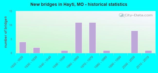
- New bridges - historical statistics
- 41920-1929
- 21930-1939
- 11950-1959
- 111960-1969
- 111970-1979
- 11980-1989
- 82000-2009
- 12010-2019

- Reconstructed bridges - Historical Statistics
- 41940-1949
- 01950-1959
- 01960-1969
- 91970-1979


- Bridge Condition - Deck
- 85.7%Good
- 4.8%Satisfactory
- 9.5%Fair

- Bridge Condition - Superstructure
- 4.8%Excellent
- 4.8%Very good
- 42.9%Good
- 28.6%Satisfactory
- 19.0%Fair

- Bridge Condition - Substructure
- 4.8%Excellent
- 14.3%Very good
- 38.1%Good
- 33.3%Satisfactory
- 4.8%Fair
- 4.8%Poor

- Bridge Condition - Channel
- 20.0%Very good
- 40.0%Good
- 26.7%Satisfactory
- 13.3%Fair

- Bridge Condition - Culverts
- 33.3%Good
- 66.7%Satisfactory
Find on map >> Show street view
Structure Number: 1204, Location: S 4 T 18 N R 12 E (Lat: 36.222511, Lng: -89.756031), Route carried "on" structure: US 412, Year Built: 2001, Status: Open, Structure Length: 8.90m (29.20ft), Average Daily Traffic: 3,943 (year 2021), Truck Traffic: 31%, Average Future Daily Traffic: 7,295 (year 2041), Design Load: HS 25 or greater, Features Intersected: BNSF RR
Minimum Vertical Clearance: 30+ m (98+ ft), Kilometerpoint: 63.729, Lanes on structure: 2, Base Highway Network: Yes, Owner: State Highway Agency, Approaching Roadway Width: 11.6m (38.1ft), Skew: 3 degrees, Material/Design: Prestressed concrete continuous, Design/Construction: Stringer/Multi-beam, Number Of Spans In Main Unit: 5, Length of Maximum Span: 18.0m (59.1ft), Curb-To-Curb Width: 11.6m (38.1ft), Out-to-Out Width: 12.4m (40.7ft)
Condition: Deck: Good, Superstructure: Good, Substructure: Very good, Operating Rating: 88.2 metric tons, Method Used To Determine Operating Rating: Load Factor (LF), Inventory Rating: 48.6 metric tons, Method Used To Determine Inventory Rating: Load Factor (LF), Structural Evaluation: Better than present minimum criteria, Deck Geometry: Better than present minimum criteria, Underclear: Superior to present desirable criteria, Approach Roadway Alignment: Equal to present desirable criteria, Designated Inspection Frequency: Every 24 months, Inspection Date: November 2020, Deck Structure Type: Concrete Cast-file-Place, Wearing Surface/Protective System: Wearing Surface: Monolithic Concrete, Deck Protection: Epoxy Coated Reinforcing
Find on map >> Show street view
Structure Number: 12041, Location: S 4 T 18 N R 12 E (Lat: 36.222758, Lng: -89.755892), Route carried "on" structure: US 412, Year Built: 2001, Status: Open, Structure Length: 8.90m (29.20ft), Average Daily Traffic: 3,301 (year 2021), Truck Traffic: 30%, Average Future Daily Traffic: 6,107 (year 2041), Design Load: HS 25 or greater, Features Intersected: BNSF RR
Minimum Vertical Clearance: 30+ m (98+ ft), Kilometerpoint: 17.915, Lanes on structure: 2, Base Highway Network: Yes, Owner: State Highway Agency, Approaching Roadway Width: 11.6m (38.1ft), Skew: 3 degrees, Material/Design: Prestressed concrete continuous, Design/Construction: Stringer/Multi-beam, Number Of Spans In Main Unit: 5, Length of Maximum Span: 18.0m (59.1ft), Curb-To-Curb Width: 11.6m (38.1ft), Out-to-Out Width: 12.4m (40.7ft)
Condition: Deck: Good, Superstructure: Good, Substructure: Very good, Operating Rating: 88.2 metric tons, Method Used To Determine Operating Rating: Load Factor (LF), Inventory Rating: 48.6 metric tons, Method Used To Determine Inventory Rating: Load Factor (LF), Structural Evaluation: Better than present minimum criteria, Deck Geometry: Better than present minimum criteria, Underclear: Superior to present desirable criteria, Approach Roadway Alignment: Equal to present desirable criteria, Designated Inspection Frequency: Every 24 months, Inspection Date: November 2020, Deck Structure Type: Concrete Cast-file-Place, Wearing Surface/Protective System: Wearing Surface: Monolithic Concrete, Deck Protection: Epoxy Coated Reinforcing
Find on map >> Show street view
Structure Number: 162, Location: S 15 T 18 N R 12 E (Lat: 36.191961, Lng: -89.753272), Route carried "on" structure: ServiceState highway 55, Year Built: 1971, Year Reconstructed: 1984, Status: Open, Structure Length: 3.60m (11.81ft), Average Daily Traffic: 12 (year 2021), Truck Traffic: 10%, Average Future Daily Traffic: 18 (year 2041), Design Load: H 15, Features Intersected: MAIN DTCH
Minimum Vertical Clearance: 30+ m (98+ ft), Kilometerpoint: 1.822, Lanes on structure: 2, Owner: State Highway Agency, Approaching Roadway Width: 5.5m (18.0ft), Skew: 2 degrees, Material/Design: Steel continuous, Design/Construction: Stringer/Multi-beam, Number Of Spans In Main Unit: 3, Length of Maximum Span: 14.0m (45.9ft), Curb-To-Curb Width: 8.5m (27.9ft), Out-to-Out Width: 9.4m (30.8ft)
Condition: Deck: Good, Superstructure: Good, Substructure: Good, Channel: Good, Operating Rating: 35.1 metric tons, Method Used To Determine Operating Rating: Allowable Stress (AS), Inventory Rating: 18.0 metric tons, Method Used To Determine Inventory Rating: Allowable Stress (AS), Structural Evaluation: Somewhat better than minimum adequacy, Deck Geometry: Better than present minimum criteria, Waterway Adequacy: Equal to present desirable criteria, Approach Roadway Alignment: Equal to present desirable criteria, Designated Inspection Frequency: Every 24 months, Inspection Date: November 2020, Deck Structure Type: Concrete Cast-file-Place, Wearing Surface/Protective System: Wearing Surface: Low Slump Concrete, Membrane: Built-up
Find on map >> Show street view
Structure Number: 1622, Location: S 15 T 18 N R 12 E (Lat: 36.191419, Lng: -89.754086), Route carried "on" structure: State highway J, Year Built: 1971, Year Reconstructed: 1984, Status: Open, Structure Length: 3.60m (11.81ft), Average Daily Traffic: 1,533 (year 2021), Truck Traffic: 9%, Average Future Daily Traffic: 2,300 (year 2041), Design Load: H 15, Features Intersected: MAIN DTCH
Minimum Vertical Clearance: 30+ m (98+ ft), Kilometerpoint: 22.363, Lanes on structure: 2, Owner: State Highway Agency, Approaching Roadway Width: 6.1m (20.0ft), Skew: 2 degrees, Material/Design: Steel continuous, Design/Construction: Stringer/Multi-beam, Number Of Spans In Main Unit: 3, Length of Maximum Span: 14.0m (45.9ft), Curb-To-Curb Width: 8.5m (27.9ft), Out-to-Out Width: 9.4m (30.8ft)
Condition: Deck: Good, Superstructure: Good, Substructure: Good, Channel: Good, Operating Rating: 35.1 metric tons, Method Used To Determine Operating Rating: Allowable Stress (AS), Inventory Rating: 18.0 metric tons, Method Used To Determine Inventory Rating: Allowable Stress (AS), Structural Evaluation: Somewhat better than minimum adequacy, Deck Geometry: Somewhat better than minimum adequacy, Waterway Adequacy: Equal to present desirable criteria, Approach Roadway Alignment: Equal to present desirable criteria, Designated Inspection Frequency: Every 24 months, Inspection Date: November 2020, Deck Structure Type: Concrete Cast-file-Place, Wearing Surface/Protective System: Wearing Surface: Bituminous, Membrane: Built-up
Find on map >> Show street view
Structure Number: 1623, Location: S 21 T 18 N R 12 E (Lat: 36.183108, Lng: -89.753433), Route carried "on" structure: Interstate 55, Year Built: 1971, Year Reconstructed: 1984, Status: Open, Structure Length: 4.02m (13.19ft), Average Daily Traffic: 12,723 (year 2021), Truck Traffic: 64%, Average Future Daily Traffic: 23,538 (year 2041), Design Load: HS 20+Mod, Features Intersected: ABANDONED RR
Minimum Vertical Clearance: 30+ m (98+ ft), Kilometerpoint: 313.057, Lanes on structure: 2, Base Highway Network: Yes, Owner: State Highway Agency, Approaching Roadway Width: 11.6m (38.1ft), Skew: 10 degrees, Material/Design: Steel continuous, Design/Construction: Stringer/Multi-beam, Number Of Spans In Main Unit: 3, Length of Maximum Span: 15.8m (51.8ft), Curb-To-Curb Width: 11.6m (38.1ft), Out-to-Out Width: 12.4m (40.7ft)
Condition: Deck: Good, Superstructure: Good, Substructure: Good, Operating Rating: 46.8 metric tons, Method Used To Determine Operating Rating: Load Factor (LF), Inventory Rating: 27.9 metric tons, Method Used To Determine Inventory Rating: Load Factor (LF), Structural Evaluation: Better than present minimum criteria, Deck Geometry: Equal to present minimum criteria, Approach Roadway Alignment: Equal to present desirable criteria, Designated Inspection Frequency: Every 24 months, Inspection Date: November 2020, Deck Structure Type: Concrete Cast-file-Place, Wearing Surface/Protective System: Wearing Surface: Low Slump Concrete, Membrane: Built-up
Find on map >> Show street view
Structure Number: 1624, Location: S 21 T 18 N R 12 E (Lat: 36.183122, Lng: -89.753761), Route carried "on" structure: Interstate 55, Year Built: 1971, Year Reconstructed: 1984, Status: Open, Structure Length: 4.02m (13.19ft), Average Daily Traffic: 11,003 (year 2021), Truck Traffic: 60%, Average Future Daily Traffic: 20,356 (year 2041), Design Load: HS 20+Mod, Features Intersected: ABANDONED RR
Minimum Vertical Clearance: 30+ m (98+ ft), Kilometerpoint: 24.617, Lanes on structure: 2, Base Highway Network: Yes, Owner: State Highway Agency, Approaching Roadway Width: 11.6m (38.1ft), Skew: 10 degrees, Material/Design: Steel continuous, Design/Construction: Stringer/Multi-beam, Number Of Spans In Main Unit: 3, Length of Maximum Span: 15.8m (51.8ft), Curb-To-Curb Width: 11.6m (38.1ft), Out-to-Out Width: 12.4m (40.7ft)
Condition: Deck: Good, Superstructure: Good, Substructure: Good, Operating Rating: 46.8 metric tons, Method Used To Determine Operating Rating: Load Factor (LF), Inventory Rating: 27.9 metric tons, Method Used To Determine Inventory Rating: Load Factor (LF), Structural Evaluation: Better than present minimum criteria, Deck Geometry: Equal to present minimum criteria, Approach Roadway Alignment: Equal to present desirable criteria, Designated Inspection Frequency: Every 24 months, Inspection Date: November 2020, Deck Structure Type: Concrete Cast-file-Place, Wearing Surface/Protective System: Wearing Surface: Low Slump Concrete, Membrane: Built-up
Find on map >> Show street view
Structure Number: 2094, Location: S 3 T 18 N R 12 E (Lat: 36.219658, Lng: -89.745433), Route carried "on" structure: Interstate 55, Year Built: 1969, Status: Open, Structure Length: 1.65m (5.41ft), Average Daily Traffic: 29,233 (year 2021), Truck Traffic: 57%, Average Future Daily Traffic: 54,081 (year 2041), Design Load: HS 20, Features Intersected: MAIN DTCH NO 6
Minimum Vertical Clearance: 30+ m (98+ ft), Kilometerpoint: 308.797, Lanes on structure: 4, Base Highway Network: Yes, Owner: State Highway Agency, Approaching Roadway Width: 39.0m (128.0ft), Skew: 24 degrees, Material/Design: Concrete continuous, Design/Construction: Culvert, Number Of Spans In Main Unit: 3, Length of Maximum Span: 4.0m (13.1ft)
Condition: Channel: Good, Culverts: Satisfactory, Inventory Rating: 67.5 metric tons, Method Used To Determine Inventory Rating: Load Factor (LF), Structural Evaluation: Equal to present minimum criteria, Waterway Adequacy: Equal to present desirable criteria, Approach Roadway Alignment: Equal to present minimum criteria, Designated Inspection Frequency: Every 24 months, Inspection Date: March 2021
Find on map >> Show street view
Structure Number: 2095, Location: S 10 T 18 N R 12 E (Lat: 36.209453, Lng: -89.740706), Route carried "on" structure: Interstate 155, Year Built: 1975, Status: Open, Structure Length: 1.64m (5.38ft), Average Daily Traffic: 9,396 (year 2021), Truck Traffic: 38%, Average Future Daily Traffic: 17,383 (year 2041), Design Load: HS 20, Features Intersected: MAIN DTCH
Minimum Vertical Clearance: 30+ m (98+ ft), Kilometerpoint: 1.316, Lanes on structure: 4, Base Highway Network: Yes, Owner: State Highway Agency, Approaching Roadway Width: 39.0m (128.0ft), Skew: 24 degrees, Material/Design: Concrete continuous, Design/Construction: Culvert, Number Of Spans In Main Unit: 3, Length of Maximum Span: 4.0m (13.1ft)
Condition: Channel: Fair, Culverts: Satisfactory, Inventory Rating: 86.4 metric tons, Method Used To Determine Inventory Rating: Load Factor (LF), Structural Evaluation: Equal to present minimum criteria, Waterway Adequacy: Equal to present desirable criteria, Approach Roadway Alignment: Equal to present desirable criteria, Designated Inspection Frequency: Every 24 months, Inspection Date: March 2021
Find on map >> Show street view
Structure Number: 2096, Location: S 10 T 18 N R 12 E (Lat: 36.215958, Lng: -89.748261), Route carried "on" structure: Interstate 55, Year Built: 1969, Year Reconstructed: 1984, Status: Open, Structure Length: 8.69m (28.51ft), Average Daily Traffic: 11,003 (year 2021), Truck Traffic: 60%, Average Future Daily Traffic: 20,356 (year 2041), Design Load: HS 20+Mod, Features Intersected: IS 155
Minimum Vertical Clearance: 30+ m (98+ ft), Kilometerpoint: 28.366, Lanes on structure: 2, Lanes under structure: 4, Base Highway Network: Yes, Owner: State Highway Agency, Approaching Roadway Width: 15.2m (49.9ft), Skew: 10 degrees, Material/Design: Steel continuous, Design/Construction: Stringer/Multi-beam, Number Of Spans In Main Unit: 3, Number Of Approach Spans: 1, Length of Maximum Span: 28.3m (92.8ft), Curb-To-Curb Width: 14.0m (45.9ft), Out-to-Out Width: 14.9m (48.9ft)
Condition: Deck: Good, Superstructure: Fair, Substructure: Satisfactory, Operating Rating: 48.6 metric tons, Method Used To Determine Operating Rating: Load Factor (LF), Inventory Rating: 29.7 metric tons, Method Used To Determine Inventory Rating: Load Factor (LF), Structural Evaluation: Somewhat better than minimum adequacy, Deck Geometry: Superior to present desirable criteria, Underclear: Somewhat better than minimum adequacy, Approach Roadway Alignment: Equal to present desirable criteria, Designated Inspection Frequency: Every 24 months, Other Special Inspection Frequency: Every 24 months, Inspection Date: Febuary 2022, Other Special Inspection Date: Febuary 2022, Deck Structure Type: Concrete Cast-file-Place, Wearing Surface/Protective System: Wearing Surface: Low Slump Concrete
Find on map >> Show street view
Structure Number: 2097, Location: S 10 T 18 N R 12 E (Lat: 36.216631, Lng: -89.748886), Route carried "on" structure: Interstate 55, Year Built: 1969, Year Reconstructed: 1984, Status: Open, Structure Length: 7.59m (24.90ft), Average Daily Traffic: 15,287 (year 2021), Truck Traffic: 57%, Average Future Daily Traffic: 28,281 (year 2041), Design Load: HS 20+Mod, Features Intersected: IS 155
Minimum Vertical Clearance: 30+ m (98+ ft), Kilometerpoint: 309.242, Lanes on structure: 2, Lanes under structure: 4, Base Highway Network: Yes, Owner: State Highway Agency, Approaching Roadway Width: 15.2m (49.9ft), Skew: 11 degrees, Material/Design: Steel continuous, Design/Construction: Stringer/Multi-beam, Number Of Spans In Main Unit: 2, Number Of Approach Spans: 2, Length of Maximum Span: 26.5m (86.9ft), Curb-To-Curb Width: 14.0m (45.9ft), Out-to-Out Width: 14.9m (48.9ft)
Condition: Deck: Good, Superstructure: Satisfactory, Substructure: Satisfactory, Operating Rating: 53.1 metric tons, Method Used To Determine Operating Rating: Load Factor (LF), Inventory Rating: 31.5 metric tons, Method Used To Determine Inventory Rating: Load Factor (LF), Structural Evaluation: Equal to present minimum criteria, Deck Geometry: Superior to present desirable criteria, Underclear: Somewhat better than minimum adequacy, Approach Roadway Alignment: Equal to present desirable criteria, Designated Inspection Frequency: Every 24 months, Other Special Inspection Frequency: Every 24 months, Inspection Date: Febuary 2022, Other Special Inspection Date: Febuary 2022, Deck Structure Type: Concrete Cast-file-Place, Wearing Surface/Protective System: Wearing Surface: Low Slump Concrete
Find on map >> Show street view
Structure Number: 2098, Location: S 10 T 18 N R 12 E (Lat: 36.217067, Lng: -89.747103), Route carried "on" structure: Interstate 55, Year Built: 1969, Year Reconstructed: 1984, Status: Open, Structure Length: 8.02m (26.31ft), Average Daily Traffic: 13,946 (year 2021), Truck Traffic: 55%, Average Future Daily Traffic: 25,800 (year 2041), Design Load: HS 20+Mod, Features Intersected: RP IS55S TO IS155S
Minimum Vertical Clearance: 30+ m (98+ ft), Kilometerpoint: 28.540, Lanes on structure: 3, Lanes under structure: 1, Base Highway Network: Yes, Owner: State Highway Agency, Approaching Roadway Width: 15.2m (49.9ft), Skew: 5 degrees, Material/Design: Steel continuous, Design/Construction: Stringer/Multi-beam, Number Of Spans In Main Unit: 4, Length of Maximum Span: 27.4m (89.9ft), Curb-To-Curb Width: 14.0m (45.9ft), Out-to-Out Width: 14.9m (48.9ft)
Condition: Deck: Good, Superstructure: Good, Substructure: Satisfactory, Operating Rating: 46.8 metric tons, Method Used To Determine Operating Rating: Load Factor (LF), Inventory Rating: 27.9 metric tons, Method Used To Determine Inventory Rating: Load Factor (LF), Structural Evaluation: Equal to present minimum criteria, Deck Geometry: Meets minimum limits, Underclear: Somewhat better than minimum adequacy, Approach Roadway Alignment: Equal to present desirable criteria, Designated Inspection Frequency: Every 24 months, Inspection Date: November 2020, Deck Structure Type: Concrete Cast-file-Place, Wearing Surface/Protective System: Wearing Surface: Low Slump Concrete, Membrane: Built-up
Find on map >> Show street view
Structure Number: 2109, Location: S 14 T 18 N R 12 E (Lat: 36.201817, Lng: -89.731569), Route carried "on" structure: County highway 505, Year Built: 1974, Status: Open, Structure Length: 8.60m (28.22ft), Average Daily Traffic: 72 (year 2021), Truck Traffic: 8%, Average Future Daily Traffic: 108 (year 2041), Design Load: H 15, Features Intersected: IS 155
Minimum Vertical Clearance: 30+ m (98+ ft), Kilometerpoint: 0.402, Lanes on structure: 2, Lanes under structure: 4, Owner: State Highway Agency, Approaching Roadway Width: 6.1m (20.0ft), Skew: 3 degrees, Material/Design: Steel continuous, Design/Construction: Stringer/Multi-beam, Number Of Spans In Main Unit: 2, Number Of Approach Spans: 2, Length of Maximum Span: 30.2m (99.1ft), Curb-To-Curb Width: 8.5m (27.9ft), Out-to-Out Width: 9.2m (30.2ft)
Condition: Deck: Good, Superstructure: Fair, Substructure: Good, Operating Rating: 27.9 metric tons, Method Used To Determine Operating Rating: Allowable Stress (AS), Inventory Rating: 16.2 metric tons, Method Used To Determine Inventory Rating: Allowable Stress (AS), Structural Evaluation: Somewhat better than minimum adequacy, Deck Geometry: Better than present minimum criteria, Underclear: Better than present minimum criteria, Approach Roadway Alignment: Equal to present desirable criteria, Designated Inspection Frequency: Every 24 months, Other Special Inspection Frequency: Every 24 months, Inspection Date: Febuary 2022, Other Special Inspection Date: Febuary 2022, Deck Structure Type: Concrete Cast-file-Place, Wearing Surface/Protective System: Wearing Surface: Monolithic Concrete
Find on map >> Show street view
Structure Number: 29372, Location: S 3 T 18 N R 12 E (Lat: 36.219158, Lng: -89.752211), Route carried "on" structure: State highway J, Year Built: 2002, Status: Open, Structure Length: 9.65m (31.66ft), Average Daily Traffic: 1,533 (year 2021), Truck Traffic: 9%, Average Future Daily Traffic: 2,300 (year 2041), Design Load: HS 20, Features Intersected: US 412, RP IS29N TO MO15
Minimum Vertical Clearance: 30+ m (98+ ft), Kilometerpoint: 25.460, Lanes on structure: 2, Lanes under structure: 6, Owner: State Highway Agency, Approaching Roadway Width: 12.2m (40.0ft), Skew: 1 degrees, Material/Design: Steel continuous, Design/Construction: Stringer/Multi-beam, Number Of Spans In Main Unit: 4, Length of Maximum Span: 27.7m (90.9ft), Curb-To-Curb Width: 12.2m (40.0ft), Out-to-Out Width: 13.0m (42.7ft)
Condition: Deck: Good, Superstructure: Very good, Substructure: Very good, Operating Rating: 66.6 metric tons, Method Used To Determine Operating Rating: Load Factor (LF), Inventory Rating: 40.5 metric tons, Method Used To Determine Inventory Rating: Load Factor (LF), Structural Evaluation: Equal to present desirable criteria, Deck Geometry: Better than present minimum criteria, Underclear: Somewhat better than minimum adequacy, Approach Roadway Alignment: Equal to present desirable criteria, Designated Inspection Frequency: Every 24 months, Inspection Date: November 2020, Deck Structure Type: Concrete Cast-file-Place, Wearing Surface/Protective System: Wearing Surface: Monolithic Concrete, Deck Protection: Epoxy Coated Reinforcing
Find on map >> Show street view
Structure Number: 32242, Location: S 23 T 18 N R 12 E (Lat: 36.189014, Lng: -89.722411), Route carried "on" structure: County highway 506, Year Built: 2002, Status: Open, Structure Length: 4.06m (13.32ft), Average Daily Traffic: 50 (year 2021), Truck Traffic: 10%, Average Future Daily Traffic: 65 (year 2041), Design Load: HS 20, Features Intersected: DRAIN DTCH
Minimum Vertical Clearance: 30+ m (98+ ft), Kilometerpoint: 0.000, Lanes on structure: 2, Owner: County Highway Agency, Approaching Roadway Width: 5.5m (18.0ft), Material/Design: Concrete continuous, Design/Construction: Channel Beam, Number Of Spans In Main Unit: 5, Length of Maximum Span: 9.1m (29.9ft), Curb-To-Curb Width: 7.3m (24.0ft), Out-to-Out Width: 7.6m (24.9ft)
Condition: Deck: Good, Superstructure: Good, Substructure: Good, Channel: Very good, Operating Rating: 49.5 metric tons, Method Used To Determine Operating Rating: Load Factor (LF), Inventory Rating: 29.7 metric tons, Method Used To Determine Inventory Rating: Load Factor (LF), Structural Evaluation: Better than present minimum criteria, Deck Geometry: Equal to present minimum criteria, Waterway Adequacy: Better than present minimum criteria, Approach Roadway Alignment: Equal to present desirable criteria, Designated Inspection Frequency: Every 24 months, Inspection Date: November 2020, Deck Structure Type: Concrete Precast Panels, Wearing Surface/Protective System: Wearing Surface: Monolithic Concrete
Find on map >> Show street view
Structure Number: 32246, Location: S 23 T 18 N R 12 E (Lat: 36.188764, Lng: -89.731364), Route carried "on" structure: County highway 505, Year Built: 2002, Status: Open, Structure Length: 4.06m (13.32ft), Average Daily Traffic: 50 (year 2021), Truck Traffic: 10%, Average Future Daily Traffic: 65 (year 2041), Design Load: HS 20, Features Intersected: DRAIN DTCH
Minimum Vertical Clearance: 30+ m (98+ ft), Kilometerpoint: 0.000, Lanes on structure: 2, Owner: County Highway Agency, Approaching Roadway Width: 5.5m (18.0ft), Material/Design: Concrete continuous, Design/Construction: Channel Beam, Number Of Spans In Main Unit: 5, Length of Maximum Span: 9.1m (29.9ft), Curb-To-Curb Width: 7.3m (24.0ft), Out-to-Out Width: 7.6m (24.9ft)
Condition: Deck: Good, Superstructure: Good, Substructure: Good, Channel: Very good, Operating Rating: 49.5 metric tons, Method Used To Determine Operating Rating: Load Factor (LF), Inventory Rating: 29.7 metric tons, Method Used To Determine Inventory Rating: Load Factor (LF), Structural Evaluation: Better than present minimum criteria, Deck Geometry: Equal to present minimum criteria, Waterway Adequacy: Better than present minimum criteria, Approach Roadway Alignment: Equal to present desirable criteria, Designated Inspection Frequency: Every 24 months, Inspection Date: November 2020, Deck Structure Type: Concrete Precast Panels, Wearing Surface/Protective System: Wearing Surface: Monolithic Concrete
Find on map >> Show street view
Structure Number: 3548, Location: S 3 T 18 N R 12 E (Lat: 36.228369, Lng: -89.743219), Route carried "on" structure: County highway 131, Year Built: 2016, Status: Open, Structure Length: 2.14m (7.02ft), Average Daily Traffic: 250 (year 2021), Truck Traffic: 10%, Average Future Daily Traffic: 325 (year 2041), Design Load: HS 20, Features Intersected: DRAIN DTCH, Facility Carried by Structure: COUNTY RD 344
Minimum Vertical Clearance: 30+ m (98+ ft), Kilometerpoint: 0.161, Lanes on structure: 2, Owner: County Highway Agency, Approaching Roadway Width: 7.3m (24.0ft), Material/Design: Prestressed concrete, Design/Construction: Box Beam or Girders - Multiple, Number Of Spans In Main Unit: 1, Length of Maximum Span: 20.9m (68.6ft), Curb-To-Curb Width: 7.4m (24.3ft), Out-to-Out Width: 7.4m (24.3ft)
Condition: Deck: Good, Superstructure: Excellent, Substructure: Excellent, Channel: Very good, Inventory Rating: 62.1 metric tons, Method Used To Determine Inventory Rating: Load Factor (LF), Structural Evaluation: Superior to present desirable criteria, Deck Geometry: Somewhat better than minimum adequacy, Waterway Adequacy: Superior to present desirable criteria, Approach Roadway Alignment: Equal to present desirable criteria, Designated Inspection Frequency: Every 24 months, Inspection Date: November 2020, Deck Structure Type: Concrete Cast-file-Place
Find on map >> Show street view
Structure Number: 3858, Location: S 2 T 18 N R 12 E (Lat: 36.233208, Lng: -89.735436), Route carried "on" structure: State highway 84, Year Built: 1987, Status: Open, Structure Length: 1.25m (4.10ft), Average Daily Traffic: 4,394 (year 2021), Truck Traffic: 7%, Average Future Daily Traffic: 7,470 (year 2041), Design Load: HS 20, Features Intersected: MAIN DTCH NO 6
Minimum Vertical Clearance: 30+ m (98+ ft), Kilometerpoint: 35.361, Lanes on structure: 2, Base Highway Network: Yes, Owner: State Highway Agency, Approaching Roadway Width: 13.4m (44.0ft), Skew: 2 degrees, Material/Design: Concrete continuous, Design/Construction: Culvert, Number Of Spans In Main Unit: 3, Length of Maximum Span: 3.7m (12.1ft)
Condition: Channel: Good, Culverts: Good, Inventory Rating: 72.9 metric tons, Method Used To Determine Inventory Rating: Load Factor (LF), Structural Evaluation: Better than present minimum criteria, Waterway Adequacy: Equal to present desirable criteria, Approach Roadway Alignment: Equal to present minimum criteria, Designated Inspection Frequency: Every 24 months, Inspection Date: March 2021
Find on map >> Show street view
Structure Number: 445, Location: S 15 T 18 N R 12 E (Lat: 36.191672, Lng: -89.753842), Route carried "on" structure: Interstate 55, Year Built: 1952, Year Reconstructed: 1984, Status: Open, Structure Length: 3.14m (10.30ft), Average Daily Traffic: 12,723 (year 2021), Truck Traffic: 64%, Average Future Daily Traffic: 23,538 (year 2041), Design Load: H 15, Features Intersected: MAIN DTCH
Minimum Vertical Clearance: 30+ m (98+ ft), Kilometerpoint: 312.122, Lanes on structure: 2, Base Highway Network: Yes, Owner: State Highway Agency, Approaching Roadway Width: 11.6m (38.1ft), Skew: 2 degrees, Material/Design: Concrete, Design/Construction: Tee Beam, Number Of Spans In Main Unit: 3, Length of Maximum Span: 11.5m (37.7ft), Curb-To-Curb Width: 11.6m (38.1ft), Out-to-Out Width: 12.4m (40.7ft)
Condition: Deck: Good, Superstructure: Satisfactory, Substructure: Good, Channel: Good, Operating Rating: 54.9 metric tons, Method Used To Determine Operating Rating: Load Factor (LF), Inventory Rating: 33.3 metric tons, Method Used To Determine Inventory Rating: Load Factor (LF), Structural Evaluation: Equal to present minimum criteria, Deck Geometry: Equal to present minimum criteria, Waterway Adequacy: Equal to present desirable criteria, Approach Roadway Alignment: Equal to present desirable criteria, Designated Inspection Frequency: Every 24 months, Inspection Date: November 2020, Deck Structure Type: Concrete Cast-file-Place, Wearing Surface/Protective System: Wearing Surface: Low Slump Concrete, Membrane: Built-up, Deck Protection: Internally Sealed
Find on map >> Show street view
Structure Number: 4459, Location: S 27 T 19 N R 12 E (Lat: 36.255514, Lng: -89.745703), Route carried "on" structure: State highway P, Year Built: 1922, Year Reconstructed: 1948, Status: Posted for load, Structure Length: 1.07m (3.51ft), Average Daily Traffic: 310 (year 2021), Truck Traffic: 12%, Average Future Daily Traffic: 465 (year 2041), Design Load: H 15, Features Intersected: LATERAL DTCH NO 22
Minimum Vertical Clearance: 30+ m (98+ ft), Kilometerpoint: 10.750, Lanes on structure: 1, Owner: State Highway Agency, Approaching Roadway Width: 5.5m (18.0ft), Material/Design: Steel, Design/Construction: Stringer/Multi-beam, Number Of Spans In Main Unit: 1, Length of Maximum Span: 9.1m (29.9ft), Curb-To-Curb Width: 6.1m (20.0ft), Out-to-Out Width: 6.8m (22.3ft)
Condition: Deck: Good, Superstructure: Satisfactory, Substructure: Satisfactory, Channel: Satisfactory, Operating Rating: 30.6 metric tons, Method Used To Determine Operating Rating: Load Factor (LF), Inventory Rating: 18.0 metric tons, Method Used To Determine Inventory Rating: Load Factor (LF), Structural Evaluation: Somewhat better than minimum adequacy, Deck Geometry: Meets minimum limits, Waterway Adequacy: Equal to present desirable criteria, Approach Roadway Alignment: Equal to present desirable criteria, Designated Inspection Frequency: Every 24 months, Inspection Date: November 2020, Deck Structure Type: Concrete Cast-file-Place, Wearing Surface/Protective System: Wearing Surface: Bituminous
Find on map >> Show street view
Structure Number: 448, Location: S 10 T 19 N R 12 E (Lat: 36.292108, Lng: -89.746128), Route carried "on" structure: State highway P, Year Built: 1922, Year Reconstructed: 1948, Status: Open, Structure Length: 1.07m (3.51ft), Average Daily Traffic: 310 (year 2021), Truck Traffic: 12%, Average Future Daily Traffic: 465 (year 2041), Design Load: H 15, Features Intersected: LATERAL DTCH NO 23
Minimum Vertical Clearance: 30+ m (98+ ft), Kilometerpoint: 6.687, Lanes on structure: 2, Owner: State Highway Agency, Approaching Roadway Width: 5.5m (18.0ft), Material/Design: Steel, Design/Construction: Stringer/Multi-beam, Number Of Spans In Main Unit: 1, Length of Maximum Span: 9.1m (29.9ft), Curb-To-Curb Width: 6.1m (20.0ft), Out-to-Out Width: 6.8m (22.3ft)
Condition: Deck: Good, Superstructure: Satisfactory, Substructure: Satisfactory, Channel: Satisfactory, Operating Rating: 27.9 metric tons, Method Used To Determine Operating Rating: Allowable Stress (AS), Inventory Rating: 16.2 metric tons, Method Used To Determine Inventory Rating: Allowable Stress (AS), Structural Evaluation: Somewhat better than minimum adequacy, Deck Geometry: Meets minimum limits, Waterway Adequacy: Equal to present desirable criteria, Approach Roadway Alignment: Equal to present desirable criteria, Designated Inspection Frequency: Every 24 months, Inspection Date: November 2020, Deck Structure Type: Concrete Cast-file-Place, Wearing Surface/Protective System: Wearing Surface: Bituminous
Find on map >> Show street view
Structure Number: 4481, Location: S 15 T 19 N R 12 E (Lat: 36.277633, Lng: -89.745956), Route carried "on" structure: State highway P, Year Built: 1922, Year Reconstructed: 1948, Status: Open, Structure Length: 1.07m (3.51ft), Average Daily Traffic: 310 (year 2021), Truck Traffic: 12%, Average Future Daily Traffic: 465 (year 2041), Design Load: H 15, Features Intersected: LATERAL DTCH NO 25
Minimum Vertical Clearance: 30+ m (98+ ft), Kilometerpoint: 8.295, Lanes on structure: 2, Owner: State Highway Agency, Approaching Roadway Width: 5.5m (18.0ft), Material/Design: Steel, Design/Construction: Stringer/Multi-beam, Number Of Spans In Main Unit: 1, Length of Maximum Span: 9.1m (29.9ft), Curb-To-Curb Width: 6.1m (20.0ft), Out-to-Out Width: 6.8m (22.3ft)
Condition: Deck: Good, Superstructure: Satisfactory, Substructure: Satisfactory, Channel: Fair, Operating Rating: 27.9 metric tons, Method Used To Determine Operating Rating: Allowable Stress (AS), Inventory Rating: 16.2 metric tons, Method Used To Determine Inventory Rating: Allowable Stress (AS), Structural Evaluation: Somewhat better than minimum adequacy, Deck Geometry: Meets minimum limits, Waterway Adequacy: Equal to present desirable criteria, Approach Roadway Alignment: Equal to present desirable criteria, Designated Inspection Frequency: Every 24 months, Inspection Date: November 2020, Deck Structure Type: Concrete Cast-file-Place, Wearing Surface/Protective System: Wearing Surface: Bituminous
Find on map >> Show street view
Structure Number: 4482, Location: S 22 T 19 N R 12 E (Lat: 36.267414, Lng: -89.745839), Route carried "on" structure: State highway P, Year Built: 1922, Year Reconstructed: 1948, Status: Open, Structure Length: 1.07m (3.51ft), Average Daily Traffic: 310 (year 2021), Truck Traffic: 12%, Average Future Daily Traffic: 465 (year 2041), Design Load: H 15, Features Intersected: LATERAL DTCH NO 24
Minimum Vertical Clearance: 30+ m (98+ ft), Kilometerpoint: 9.429, Lanes on structure: 2, Owner: State Highway Agency, Approaching Roadway Width: 5.5m (18.0ft), Material/Design: Steel, Design/Construction: Stringer/Multi-beam, Number Of Spans In Main Unit: 1, Length of Maximum Span: 9.1m (29.9ft), Curb-To-Curb Width: 6.1m (20.0ft), Out-to-Out Width: 6.8m (22.3ft)
Condition: Deck: Satisfactory, Superstructure: Satisfactory, Substructure: Satisfactory, Channel: Satisfactory, Operating Rating: 27.9 metric tons, Method Used To Determine Operating Rating: Allowable Stress (AS), Inventory Rating: 16.2 metric tons, Method Used To Determine Inventory Rating: Allowable Stress (AS), Structural Evaluation: Somewhat better than minimum adequacy, Deck Geometry: Meets minimum limits, Waterway Adequacy: Equal to present desirable criteria, Approach Roadway Alignment: Equal to present desirable criteria, Designated Inspection Frequency: Every 24 months, Inspection Date: November 2020, Deck Structure Type: Concrete Cast-file-Place, Wearing Surface/Protective System: Wearing Surface: Bituminous
Find on map >> Show street view
Structure Number: 5332, Location: S 2 T 18 N R 12 E (Lat: 36.225864, Lng: -89.719506), Route carried "on" structure: State highway 84, Year Built: 1930, Year Reconstructed: 1983, Status: Open, Structure Length: 3.41m (11.19ft), Average Daily Traffic: 14,167 (year 2021), Truck Traffic: 7%, Average Future Daily Traffic: 24,084 (year 2041), Design Load: H 20, Features Intersected: DRAIN DTCH NO 6
Minimum Vertical Clearance: 30+ m (98+ ft), Kilometerpoint: 36.996, Lanes on structure: 2, Base Highway Network: Yes, Owner: State Highway Agency, Approaching Roadway Width: 13.4m (44.0ft), Skew: 5 degrees, Material/Design: Concrete, Design/Construction: Tee Beam, Number Of Spans In Main Unit: 3, Length of Maximum Span: 14.5m (47.6ft), Curb-To-Curb Width: 9.4m (30.8ft), Out-to-Out Width: 9.9m (32.5ft)
Condition: Deck: Fair, Superstructure: Fair, Substructure: Fair, Channel: Satisfactory, Operating Rating: 33.3 metric tons, Method Used To Determine Operating Rating: Load Factor (LF), Inventory Rating: 19.8 metric tons, Method Used To Determine Inventory Rating: Load Factor (LF), Structural Evaluation: Somewhat better than minimum adequacy, Deck Geometry: High priority of corrective action, Waterway Adequacy: Equal to present desirable criteria, Approach Roadway Alignment: Equal to present desirable criteria, Length Of Structure Improvement: 0.43m (1.41ft), Designated Inspection Frequency: Every 24 months, Inspection Date: November 2020, Bridge Improvement Cost: $541,000, Roadway Improvement Cost: $54,000, Total Project Cost: $812,000 ( Estimate for 2022), Deck Structure Type: Concrete Cast-file-Place, Wearing Surface/Protective System: Wearing Surface: Bituminous, Membrane: Built-up
Find on map >> Show street view
Structure Number: 9014, Location: S 9 T 19 N R 12 E (Lat: 36.299106, Lng: -89.764578), Route carried "on" structure: State highway K, Year Built: 1934, Status: Posted for load, Structure Length: 4.82m (15.81ft), Average Daily Traffic: 54 (year 2021), Truck Traffic: 11%, Average Future Daily Traffic: 81 (year 2041), Design Load: H 10, Features Intersected: MAIN DTCH NO 8
Minimum Vertical Clearance: 30+ m (98+ ft), Kilometerpoint: 17.342, Lanes on structure: 2, Owner: State Highway Agency, Approaching Roadway Width: 5.5m (18.0ft), Skew: 3 degrees, Material/Design: Steel, Design/Construction: Stringer/Multi-beam, Number Of Spans In Main Unit: 5, Length of Maximum Span: 9.4m (30.8ft), Curb-To-Curb Width: 6.1m (20.0ft), Out-to-Out Width: 6.5m (21.3ft)
Condition: Deck: Fair, Superstructure: Fair, Substructure: Poor, Channel: Good, Operating Rating: 21.6 metric tons, Method Used To Determine Operating Rating: Load Factor (LF), Inventory Rating: 12.6 metric tons, Method Used To Determine Inventory Rating: Load Factor (LF), Structural Evaluation: Meets minimum limits, Deck Geometry: Somewhat better than minimum adequacy, Waterway Adequacy: Equal to present desirable criteria, Approach Roadway Alignment: Equal to present desirable criteria, Bridge Posting: Required (Relationship of Operating Rating to Maximum Legal Load: 30.0 - 39.9% below), Length Of Structure Improvement: 0.58m (1.90ft), Designated Inspection Frequency: Every 12 months, Inspection Date: November 2021, Bridge Improvement Cost: $593,000, Roadway Improvement Cost: $59,000, Total Project Cost: $889,000 ( Estimate for 2022), Deck Structure Type: Concrete Cast-file-Place, Wearing Surface/Protective System: Wearing Surface: Bituminous
Find on map >> Show street view
Structure Number: 1214, Location: S 3 T 18 N R 12 E (Lat: 36.224369, Lng: -89.739847), Route carried "under" structure: County highway 344, Year Built: 1969, Structure Length: 0. m, Average Daily Traffic: 340 (year 2021), Truck Traffic: 10%, Features Intersected: CRD 344, Facility Carried by Structure: IS 55 S
Minimum Vertical Clearance: 30+ m (98+ ft), Kilometerpoint: 0.681, Lanes on structure: 2, Lanes under structure: 2, Material/Design: Steel continuous, Design/Construction: Stringer/Multi-beam, Length of Maximum Span: 20.7m (67.9ft)
Find on map >> Show street view
Structure Number: 1215, Location: S 3 T 18 N R 12 E (Lat: 36.224169, Lng: -89.739583), Route carried "under" structure: County highway 344, Year Built: 1969, Structure Length: 0. m, Average Daily Traffic: 340 (year 2021), Truck Traffic: 10%, Features Intersected: CRD 344, Facility Carried by Structure: IS 55 N
Minimum Vertical Clearance: 30+ m (98+ ft), Kilometerpoint: 0.713, Lanes on structure: 2, Lanes under structure: 2, Material/Design: Steel continuous, Design/Construction: Stringer/Multi-beam, Length of Maximum Span: 20.7m (67.9ft)
Find on map >> Show street view
Structure Number: 1625, Location: S 27 T 18 N R 12 E (Lat: 36.171147, Lng: -89.753400), Route carried "under" structure: Interstate 55, Year Built: 1971, Structure Length: 0. m, Average Daily Traffic: 12,723 (year 2021), Truck Traffic: 64%, Features Intersected: IS 55, Facility Carried by Structure: RT U E
Minimum Vertical Clearance: 5.05m (16.57ft), Kilometerpoint: 314.417, Lanes on structure: 2, Lanes under structure: 2, Material/Design: Steel continuous, Design/Construction: Stringer/Multi-beam, Length of Maximum Span: 26.2m (86.0ft)
Find on map >> Show street view
Structure Number: 1625, Location: S 27 T 18 N R 12 E (Lat: 36.171147, Lng: -89.753400), Route carried "under" structure: Interstate 55, Year Built: 1971, Structure Length: 0. m, Average Daily Traffic: 9,254 (year 2021), Truck Traffic: 43%, Features Intersected: IS 55, Facility Carried by Structure: RT U E
Minimum Vertical Clearance: 5.05m (16.57ft), Kilometerpoint: 23.308, Lanes on structure: 2, Lanes under structure: 2, Material/Design: Steel continuous, Design/Construction: Stringer/Multi-beam, Length of Maximum Span: 26.2m (86.0ft)
Find on map >> Show street view
Structure Number: 2096, Location: S 10 T 18 N R 12 E (Lat: 36.215958, Lng: -89.748261), Route carried "under" structure: Interstate 155, Year Built: 1969, Structure Length: 0. m, Average Daily Traffic: 4,311 (year 2021), Truck Traffic: 38%, Features Intersected: IS 155, Facility Carried by Structure: IS 55 N
Minimum Vertical Clearance: 4.95m (16.24ft), Kilometerpoint: 0.332, Lanes on structure: 2, Lanes under structure: 2, Material/Design: Steel continuous, Design/Construction: Stringer/Multi-beam, Length of Maximum Span: 28.3m (92.8ft)
Find on map >> Show street view
Structure Number: 2096, Location: S 10 T 18 N R 12 E (Lat: 36.215958, Lng: -89.748261), Route carried "under" structure: Interstate 155, Year Built: 1969, Structure Length: 0. m, Average Daily Traffic: 5,085 (year 2021), Truck Traffic: 42%, Features Intersected: IS 155, Facility Carried by Structure: IS 55 N
Minimum Vertical Clearance: 4.90m (16.08ft), Kilometerpoint: 16.945, Lanes on structure: 2, Lanes under structure: 2, Material/Design: Steel continuous, Design/Construction: Stringer/Multi-beam, Length of Maximum Span: 28.3m (92.8ft)
Find on map >> Show street view
Structure Number: 2097, Location: S 10 T 18 N R 12 E (Lat: 36.216631, Lng: -89.748886), Route carried "under" structure: Interstate 155, Year Built: 1969, Structure Length: 0. m, Average Daily Traffic: 5,085 (year 2021), Truck Traffic: 42%, Features Intersected: IS 155, Facility Carried by Structure: IS 55 S
Minimum Vertical Clearance: 4.93m (16.17ft), Kilometerpoint: 17.038, Lanes on structure: 2, Lanes under structure: 2, Material/Design: Steel continuous, Design/Construction: Stringer/Multi-beam, Length of Maximum Span: 26.5m (86.9ft)
Find on map >> Show street view
Structure Number: 2097, Location: S 10 T 18 N R 12 E (Lat: 36.216631, Lng: -89.748886), Route carried "under" structure: Interstate 155, Year Built: 1969, Structure Length: 0. m, Average Daily Traffic: 4,311 (year 2021), Truck Traffic: 38%, Features Intersected: IS 155, Facility Carried by Structure: IS 55 S
Minimum Vertical Clearance: 4.93m (16.17ft), Kilometerpoint: 0.240, Lanes on structure: 2, Lanes under structure: 2, Material/Design: Steel continuous, Design/Construction: Stringer/Multi-beam, Length of Maximum Span: 26.5m (86.9ft)
Find on map >> Show street view
Structure Number: 2098, Location: S 10 T 18 N R 12 E (Lat: 36.217067, Lng: -89.747103), Route carried "under" structure: Ramp State highway , Year Built: 1969, Structure Length: 0. m, Average Daily Traffic: 1,945 (year 2021), Truck Traffic: 40%, Features Intersected: RP IS55S TO IS155S, Facility Carried by Structure: IS 55 N
Minimum Vertical Clearance: 5.49m (18.01ft), Kilometerpoint: 0.249, Lanes on structure: 3, Lanes under structure: 1, Material/Design: Steel continuous, Design/Construction: Stringer/Multi-beam, Length of Maximum Span: 27.4m (89.9ft)
Find on map >> Show street view
Structure Number: 2099, Location: S 10 T 18 N R 12 E (Lat: 36.215172, Lng: -89.746419), Route carried "under" structure: Interstate 155, Year Built: 1974, Structure Length: 0. m, Average Daily Traffic: 5,085 (year 2021), Truck Traffic: 42%, Features Intersected: IS 155
Minimum Vertical Clearance: 5.13m (16.83ft), Kilometerpoint: 16.753, Lanes on structure: 1, Lanes under structure: 2, Material/Design: Steel continuous, Design/Construction: Stringer/Multi-beam, Length of Maximum Span: 34.7m (113.8ft)
Find on map >> Show street view
Structure Number: 2109, Location: S 14 T 18 N R 12 E (Lat: 36.201817, Lng: -89.731569), Route carried "under" structure: Interstate 155, Year Built: 1974, Structure Length: 0. m, Average Daily Traffic: 4,311 (year 2021), Truck Traffic: 38%, Features Intersected: IS 155, Facility Carried by Structure: 505 S
Minimum Vertical Clearance: 5.28m (17.32ft), Kilometerpoint: 2.517, Lanes on structure: 2, Lanes under structure: 2, Material/Design: Steel continuous, Design/Construction: Stringer/Multi-beam, Length of Maximum Span: 30.2m (99.1ft)
Find on map >> Show street view
Structure Number: 2109, Location: S 14 T 18 N R 12 E (Lat: 36.201817, Lng: -89.731569), Route carried "under" structure: Interstate 155, Year Built: 1974, Structure Length: 0. m, Average Daily Traffic: 5,085 (year 2021), Truck Traffic: 42%, Features Intersected: IS 155, Facility Carried by Structure: 505 S
Minimum Vertical Clearance: 5.23m (17.16ft), Kilometerpoint: 14.759, Lanes on structure: 2, Lanes under structure: 2, Material/Design: Steel continuous, Design/Construction: Stringer/Multi-beam, Length of Maximum Span: 30.2m (99.1ft)
Find on map >> Show street view
Structure Number: 29372, Location: S 3 T 18 N R 12 E (Lat: 36.219158, Lng: -89.752211), Route carried "under" structure: US 412, Year Built: 2002, Structure Length: 0. m, Average Daily Traffic: 3,301 (year 2021), Truck Traffic: 30%, Features Intersected: US 412, Facility Carried by Structure: RT J E
Minimum Vertical Clearance: 5.08m (16.67ft), Kilometerpoint: 17.455, Lanes on structure: 2, Lanes under structure: 2, Material/Design: Steel continuous, Design/Construction: Stringer/Multi-beam, Length of Maximum Span: 27.7m (90.9ft)
Find on map >> Show street view
Structure Number: 29372, Location: S 3 T 18 N R 12 E (Lat: 36.219158, Lng: -89.752211), Route carried "under" structure: US 412, Year Built: 2002, Structure Length: 0. m, Average Daily Traffic: 3,943 (year 2021), Truck Traffic: 31%, Features Intersected: US 412, Facility Carried by Structure: RT J E
Minimum Vertical Clearance: 5.08m (16.67ft), Kilometerpoint: 64.279, Lanes on structure: 2, Lanes under structure: 2, Material/Design: Steel continuous, Design/Construction: Stringer/Multi-beam, Length of Maximum Span: 27.7m (90.9ft)
Find on map >> Show street view
Structure Number: 29372, Location: S 3 T 18 N R 12 E (Lat: 36.219158, Lng: -89.752211), Route carried "under" structure: Ramp State highway , Year Built: 2002, Structure Length: 0. m, Average Daily Traffic: 1,455 (year 2021), Truck Traffic: 19%, Features Intersected: RP IS29N TO MO152W, Facility Carried by Structure: RT J E
Minimum Vertical Clearance: 5.27m (17.29ft), Kilometerpoint: 1.529, Lanes on structure: 2, Lanes under structure: 2, Material/Design: Steel continuous, Design/Construction: Stringer/Multi-beam, Length of Maximum Span: 27.7m (90.9ft)