Bridge Statistics for Hebron, Indiana (IN)
Condition, Traffic, Stress, Structural Evaluation, Project Costs
- National Bridge Inventory (NBI) Statistics
- 13Number of bridges
- 79ft / 23.7mTotal length
- $3,164,000Total costs
- 7,017Total average daily traffic
- 390Total average daily truck traffic
- 12,812Total future (year 2038) average daily traffic
- National Bridge Inventory (NBI) Registered Bridges for Hebron
- No street view available for this location
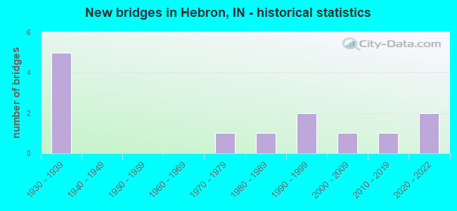
- New bridges - historical statistics
- 51930-1939
- 11970-1979
- 11980-1989
- 21990-1999
- 12000-2009
- 12010-2019
- 22020-2022

- Reconstructed bridges - Historical Statistics
- 11950-1959
- 11960-1969
- 11970-1979
- 11980-1989
- 11990-1999

- Bridge Condition - Deck
- 16.7%Very good
- 41.7%Good
- 33.3%Satisfactory
- 8.3%Fair

- Bridge Condition - Superstructure
- 8.3%Excellent
- 16.7%Very good
- 33.3%Good
- 33.3%Satisfactory
- 8.3%Fair

- Bridge Condition - Substructure
- 8.3%Excellent
- 8.3%Very good
- 33.3%Good
- 8.3%Satisfactory
- 33.3%Fair
- 8.3%Poor

- Bridge Condition - Channel
- 7.7%Very good
- 30.8%Good
- 30.8%Satisfactory
- 23.1%Fair
- 7.7%Poor
Find on map >> Show street view
Structure Number: 4500007, Location: 00.50 E. of GRAND (Lat: 41.303950, Lng: -87.247531), Route carried "on" structure: County highway , Year Built: 2003, Status: Open, Structure Length: 2.93m (9.61ft), Average Daily Traffic: 138 (year 2012), Truck Traffic: 2%, Average Future Daily Traffic: 183 (year 2040), Design Load: HS 20, Features Intersected: M J BROWN DITCH, Facility Carried by Structure: 173RD AVENUE
Minimum Vertical Clearance: 30+ m (98+ ft), Kilometerpoint: 0.000, Lanes on structure: 2, Owner: County Highway Agency, Approaching Roadway Width: 6.1m (20.0ft), Material/Design: Prestressed concrete continuous, Design/Construction: Box Beam or Girders - Single/Spread, Number Of Spans In Main Unit: 3, Length of Maximum Span: 10.1m (33.1ft), Curb-To-Curb Width: 9.1m (29.9ft), Out-to-Out Width: 10.1m (33.1ft)
Condition: Deck: Good, Superstructure: Very good, Substructure: Good, Channel: Fair, Operating Rating: 54.5 metric tons, Method Used To Determine Operating Rating: Field evaluation and documented engineering judgment, Inventory Rating: 32.7 metric tons, Method Used To Determine Inventory Rating: Field evaluation and documented engineering judgment, Structural Evaluation: Better than present minimum criteria, Deck Geometry: Equal to present minimum criteria, Waterway Adequacy: Superior to present desirable criteria, Approach Roadway Alignment: Equal to present desirable criteria, Designated Inspection Frequency: Every 24 months, Inspection Date: August 2020, Deck Structure Type: Concrete Cast-file-Place, Wearing Surface/Protective System: Wearing Surface: Monolithic Concrete
Find on map >> Show street view
Structure Number: 4500009, Location: 00.40 E. of GRAND (Lat: 41.318531, Lng: -87.250769), Route carried "on" structure: County highway , Year Built: 1991, Status: Posted for load, Structure Length: 1.74m (5.71ft), Average Daily Traffic: 167 (year 2012), Truck Traffic: 3%, Average Future Daily Traffic: 221 (year 2040), Design Load: HS 20, Features Intersected: STONEY RUN DITCH, Facility Carried by Structure: 165TH AVENUE
Minimum Vertical Clearance: 30+ m (98+ ft), Kilometerpoint: 0.000, Lanes on structure: 2, Owner: County Highway Agency, Approaching Roadway Width: 5.8m (19.0ft), Skew: 4 degrees, Material/Design: Wood or Timber, Design/Construction: Slab, Number Of Spans In Main Unit: 3, Length of Maximum Span: 7.9m (25.9ft), Curb or Sidewalk Widths: Left: 0.2m (0.7ft), Right: 0.2m (0.7ft), Curb-To-Curb Width: 8.0m (26.2ft), Out-to-Out Width: 8.4m (27.6ft)
Condition: Deck: Good, Superstructure: Good, Substructure: Good, Channel: Good, Operating Rating: 44.0 metric tons, Method Used To Determine Operating Rating: Allowable Stress (AS), Inventory Rating: 31.1 metric tons, Method Used To Determine Inventory Rating: Allowable Stress (AS), Structural Evaluation: Better than present minimum criteria, Deck Geometry: Somewhat better than minimum adequacy, Waterway Adequacy: Equal to present desirable criteria, Approach Roadway Alignment: Equal to present desirable criteria, Designated Inspection Frequency: Every 24 months, Inspection Date: August 2020, Deck Structure Type: Wood or Timber, Wearing Surface/Protective System: Wearing Surface: Bituminous, Membrane: Preformed Fabric
Find on map >> Show street view
Structure Number: 4500011, Location: 00.10 E of HANCOCK (Lat: 41.333050, Lng: -87.261511), Route carried "on" structure: County highway , Year Built: 1987, Status: Open, Structure Length: 0.98m (3.22ft), Average Daily Traffic: 241 (year 2012), Truck Traffic: 3%, Average Future Daily Traffic: 319 (year 2040), Features Intersected: MIDDLE BRANCH STONEY RUN, Facility Carried by Structure: 157TH AVENUE
Minimum Vertical Clearance: 30+ m (98+ ft), Kilometerpoint: 0.000, Lanes on structure: 2, Owner: County Highway Agency, Approaching Roadway Width: 6.1m (20.0ft), Material/Design: Wood or Timber, Design/Construction: Slab, Number Of Spans In Main Unit: 1, Length of Maximum Span: 9.4m (30.8ft), Curb or Sidewalk Widths: Left: 0.2m (0.7ft), Right: 0.2m (0.7ft), Curb-To-Curb Width: 8.1m (26.6ft), Out-to-Out Width: 8.5m (27.9ft)
Condition: Deck: Good, Superstructure: Good, Substructure: Good, Channel: Good, Operating Rating: 47.6 metric tons, Method Used To Determine Operating Rating: Allowable Stress (AS), Inventory Rating: 33.1 metric tons, Method Used To Determine Inventory Rating: Allowable Stress (AS), Structural Evaluation: Better than present minimum criteria, Deck Geometry: Somewhat better than minimum adequacy, Waterway Adequacy: Better than present minimum criteria, Approach Roadway Alignment: Equal to present desirable criteria, Length Of Structure Improvement: 0.98m (3.22ft), Designated Inspection Frequency: Every 24 months, Inspection Date: August 2020, Bridge Improvement Cost: $12,000, Roadway Improvement Cost: $15,000, Total Project Cost: $27,000 ( Estimate for 2020), Deck Structure Type: Wood or Timber, Wearing Surface/Protective System: Wearing Surface: Bituminous, Membrane: Preformed Fabric
Find on map >> Show street view
Structure Number: 4500012, Location: 00.30 W of MONTGOMRY (Lat: 41.333111, Lng: -87.256681), Route carried "on" structure: County highway , Year Built: 1993, Status: Open, Structure Length: 0.98m (3.22ft), Average Daily Traffic: 241 (year 2012), Truck Traffic: 3%, Average Future Daily Traffic: 319 (year 2040), Features Intersected: EAST BRANCH STONEY RUN, Facility Carried by Structure: 157TH AVENUE
Minimum Vertical Clearance: 30+ m (98+ ft), Kilometerpoint: 0.000, Lanes on structure: 2, Owner: County Highway Agency, Approaching Roadway Width: 6.1m (20.0ft), Material/Design: Wood or Timber, Design/Construction: Slab, Number Of Spans In Main Unit: 1, Length of Maximum Span: 9.4m (30.8ft), Curb or Sidewalk Widths: Left: 0.2m (0.7ft), Right: 0.2m (0.7ft), Curb-To-Curb Width: 8.0m (26.2ft), Out-to-Out Width: 8.4m (27.6ft)
Condition: Deck: Good, Superstructure: Good, Substructure: Good, Channel: Good, Operating Rating: 47.5 metric tons, Method Used To Determine Operating Rating: Allowable Stress (AS), Inventory Rating: 33.1 metric tons, Method Used To Determine Inventory Rating: Allowable Stress (AS), Structural Evaluation: Better than present minimum criteria, Deck Geometry: Somewhat better than minimum adequacy, Waterway Adequacy: Superior to present desirable criteria, Approach Roadway Alignment: Equal to present desirable criteria, Designated Inspection Frequency: Every 24 months, Inspection Date: August 2020, Deck Structure Type: Wood or Timber, Wearing Surface/Protective System: Wearing Surface: Bituminous, Membrane: Preformed Fabric
Find on map >> Show street view
Structure Number: 640004, Location: 01.30 S 1000 S (Lat: 41.268919, Lng: -87.185100), Route carried "on" structure: Alternate County highway 95, Year Built: 1930, Year Reconstructed: 1964, Status: Posted for load, Structure Length: 1.89m (6.20ft), Average Daily Traffic: 1,320 (year 2018), Truck Traffic: 6%, Average Future Daily Traffic: 2,490 (year 2038), Features Intersected: BREYFOGEL DITCH, Facility Carried by Structure: CR 625W
Minimum Vertical Clearance: 30+ m (98+ ft), Kilometerpoint: 0.000, Lanes on structure: 2, Owner: County Highway Agency, Approaching Roadway Width: 6.4m (21.0ft), Material/Design: Prestressed concrete, Design/Construction: Box Beam or Girders - Multiple, Number Of Spans In Main Unit: 1, Length of Maximum Span: 17.4m (57.1ft), Curb-To-Curb Width: 7.3m (24.0ft), Out-to-Out Width: 7.6m (24.9ft)
Condition: Deck: Fair, Superstructure: Fair, Substructure: Fair, Channel: Fair, Operating Rating: 54.5 metric tons, Method Used To Determine Operating Rating: Load and Resistance Factor (LRFR), Inventory Rating: 39.0 metric tons, Method Used To Determine Inventory Rating: Load and Resistance Factor (LRFR), Structural Evaluation: Somewhat better than minimum adequacy, Deck Geometry: Meets minimum limits, Waterway Adequacy: Equal to present minimum criteria, Approach Roadway Alignment: Equal to present minimum criteria, Length Of Structure Improvement: 2.62m (8.60ft), Designated Inspection Frequency: Every 24 months, Inspection Date: May 2020, Bridge Improvement Cost: $1,199,000, Roadway Improvement Cost: $278,000, Total Project Cost: $1,773,000 ( Estimate for 2020), Deck Structure Type: Concrete Precast Panels, Wearing Surface/Protective System: Wearing Surface: Bituminous
Find on map >> Show street view
Structure Number: 6400042, Location: 00.20 E CR 625 W (Lat: 41.288689, Lng: -87.180350), Route carried "on" structure: Alternate County highway 1000, Year Built: 1930, Year Reconstructed: 1965, Status: Open, Structure Length: 1.68m (5.51ft), Average Daily Traffic: 980 (year 2018), Truck Traffic: 6%, Average Future Daily Traffic: 1,850 (year 2038), Features Intersected: COBBS CREEK
Minimum Vertical Clearance: 30+ m (98+ ft), Kilometerpoint: 0.000, Lanes on structure: 2, Owner: County Highway Agency, Approaching Roadway Width: 6.4m (21.0ft), Material/Design: Prestressed concrete, Design/Construction: Box Beam or Girders - Multiple, Number Of Spans In Main Unit: 1, Length of Maximum Span: 16.2m (53.1ft), Curb-To-Curb Width: 7.9m (25.9ft), Out-to-Out Width: 8.0m (26.2ft)
Condition: Deck: Satisfactory, Superstructure: Satisfactory, Substructure: Satisfactory, Channel: Satisfactory, Operating Rating: 44.9 metric tons, Method Used To Determine Operating Rating: Load Factor (LF), Inventory Rating: 26.9 metric tons, Method Used To Determine Inventory Rating: Load Factor (LF), Structural Evaluation: Equal to present minimum criteria, Deck Geometry: Somewhat better than minimum adequacy, Waterway Adequacy: Equal to present minimum criteria, Approach Roadway Alignment: Equal to present desirable criteria, Designated Inspection Frequency: Every 24 months, Inspection Date: May 2020, Deck Structure Type: Concrete Precast Panels, Wearing Surface/Protective System: Wearing Surface: Bituminous, Membrane: Preformed Fabric
Find on map >> Show street view
Structure Number: 6400056, Location: 00.60 N 750 S (Lat: 41.333239, Lng: -87.125481), Route carried "on" structure: Alternate County highway 133, Year Built: 1930, Year Reconstructed: 1979, Status: Open, Structure Length: 1.13m (3.71ft), Average Daily Traffic: 110 (year 2018), Truck Traffic: 6%, Average Future Daily Traffic: 210 (year 2038), Design Load: HS 20, Features Intersected: CORNELL DITCH, Facility Carried by Structure: CR 300W
Minimum Vertical Clearance: 30+ m (98+ ft), Kilometerpoint: 0.000, Lanes on structure: 2, Owner: County Highway Agency, Approaching Roadway Width: 6.1m (20.0ft), Material/Design: Prestressed concrete, Design/Construction: Box Beam or Girders - Multiple, Number Of Spans In Main Unit: 1, Length of Maximum Span: 9.4m (30.8ft), Curb-To-Curb Width: 7.3m (24.0ft), Out-to-Out Width: 7.4m (24.3ft)
Condition: Deck: Good, Superstructure: Good, Substructure: Poor, Channel: Satisfactory, Operating Rating: 45.5 metric tons, Method Used To Determine Operating Rating: Load and Resistance Factor (LRFR), Inventory Rating: 35.0 metric tons, Method Used To Determine Inventory Rating: Load and Resistance Factor (LRFR), Structural Evaluation: Meets minimum limits, Deck Geometry: Somewhat better than minimum adequacy, Waterway Adequacy: Equal to present minimum criteria, Approach Roadway Alignment: Equal to present minimum criteria, Length Of Structure Improvement: 1.80m (5.91ft), Designated Inspection Frequency: Every 12 months, Inspection Date: May 2021, Bridge Improvement Cost: $851,000, Roadway Improvement Cost: $287,000, Total Project Cost: $1,364,000 ( Estimate for 2021), Deck Structure Type: Concrete Precast Panels, Wearing Surface/Protective System: Wearing Surface: Bituminous, Membrane: Preformed Fabric
Find on map >> Show street view
Structure Number: 6400057, Location: 00.70 E JCT SR 2 (Lat: 41.303561, Lng: -87.187217), Route carried "on" structure: Alternate County highway 14, Year Built: 1930, Year Reconstructed: 1997, Status: Open, Structure Length: 1.68m (5.51ft), Average Daily Traffic: 580 (year 2018), Truck Traffic: 6%, Average Future Daily Traffic: 1,100 (year 2038), Features Intersected: COBBS CREEK, Facility Carried by Structure: CR 900S
Minimum Vertical Clearance: 30+ m (98+ ft), Kilometerpoint: 0.000, Lanes on structure: 2, Owner: County Highway Agency, Approaching Roadway Width: 5.8m (19.0ft), Material/Design: Prestressed concrete, Design/Construction: Box Beam or Girders - Multiple, Number Of Spans In Main Unit: 1, Length of Maximum Span: 14.0m (45.9ft), Curb-To-Curb Width: 8.5m (27.9ft), Out-to-Out Width: 8.6m (28.2ft)
Condition: Deck: Satisfactory, Superstructure: Satisfactory, Substructure: Fair, Channel: Poor, Operating Rating: 55.9 metric tons, Method Used To Determine Operating Rating: Load and Resistance Factor (LRFR), Inventory Rating: 40.9 metric tons, Method Used To Determine Inventory Rating: Load and Resistance Factor (LRFR), Structural Evaluation: Somewhat better than minimum adequacy, Deck Geometry: Somewhat better than minimum adequacy, Waterway Adequacy: Better than present minimum criteria, Approach Roadway Alignment: Equal to present desirable criteria, Designated Inspection Frequency: Every 24 months, Inspection Date: May 2020, Deck Structure Type: Concrete Precast Panels, Wearing Surface/Protective System: Wearing Surface: Bituminous, Membrane: Preformed Fabric
Find on map >> Show street view
Structure Number: 6400061, Location: 00.20 N 500 S (Lat: 41.367450, Lng: -87.181075), Route carried "on" structure: Alternate County highway 9, Year Built: 1974, Status: Open, Structure Length: 1.19m (3.90ft), Average Daily Traffic: 280 (year 2018), Truck Traffic: 6%, Average Future Daily Traffic: 530 (year 2038), Design Load: HS 20, Features Intersected: CORNELL DITCH, Facility Carried by Structure: CR 600W
Minimum Vertical Clearance: 30+ m (98+ ft), Kilometerpoint: 0.000, Lanes on structure: 2, Owner: County Highway Agency, Approaching Roadway Width: 5.5m (18.0ft), Material/Design: Prestressed concrete, Design/Construction: Box Beam or Girders - Multiple, Number Of Spans In Main Unit: 1, Length of Maximum Span: 10.7m (35.1ft), Curb-To-Curb Width: 7.3m (24.0ft), Out-to-Out Width: 7.4m (24.3ft)
Condition: Deck: Satisfactory, Superstructure: Satisfactory, Substructure: Fair, Channel: Satisfactory, Operating Rating: 49.9 metric tons, Method Used To Determine Operating Rating: Load and Resistance Factor (LRFR), Inventory Rating: 41.3 metric tons, Method Used To Determine Inventory Rating: Load and Resistance Factor (LRFR), Structural Evaluation: Somewhat better than minimum adequacy, Deck Geometry: Somewhat better than minimum adequacy, Waterway Adequacy: Equal to present minimum criteria, Approach Roadway Alignment: Equal to present desirable criteria, Designated Inspection Frequency: Every 24 months, Inspection Date: May 2020, Deck Structure Type: Concrete Precast Panels, Wearing Surface/Protective System: Wearing Surface: Bituminous
Find on map >> Show street view
Structure Number: 64001, Location: 00.30 S CR 600 S (Lat: 41.342011, Lng: -87.142867), Route carried "on" structure: Alternate County highway 23, Year Built: 1930, Year Reconstructed: 1993, Status: Open, Structure Length: 0.67m (2.20ft), Average Daily Traffic: 360 (year 2018), Truck Traffic: 6%, Average Future Daily Traffic: 680 (year 2038), Design Load: H 20, Features Intersected: CORNELL DITCH, Facility Carried by Structure: CR 400W
Minimum Vertical Clearance: 30+ m (98+ ft), Kilometerpoint: 0.000, Lanes on structure: 2, Owner: County Highway Agency, Approaching Roadway Width: 5.8m (19.0ft), Material/Design: Concrete, Design/Construction: Stringer/Multi-beam, Number Of Spans In Main Unit: 1, Length of Maximum Span: 6.1m (20.0ft), Curb-To-Curb Width: 8.0m (26.2ft), Out-to-Out Width: 8.2m (26.9ft)
Condition: Deck: Satisfactory, Superstructure: Satisfactory, Substructure: Fair, Channel: Fair, Operating Rating: 32.7 metric tons, Method Used To Determine Operating Rating: Field evaluation and documented engineering judgment, Inventory Rating: 32.7 metric tons, Method Used To Determine Inventory Rating: Field evaluation and documented engineering judgment, Structural Evaluation: Somewhat better than minimum adequacy, Deck Geometry: Somewhat better than minimum adequacy, Waterway Adequacy: Somewhat better than minimum adequacy, Approach Roadway Alignment: Equal to present desirable criteria, Designated Inspection Frequency: Every 24 months, Inspection Date: May 2020, Deck Structure Type: Concrete Cast-file-Place, Wearing Surface/Protective System: Wearing Surface: Bituminous
Find on map >> Show street view
Structure Number: 6400162, Location: 00.70 E CR 400 W (Lat: 41.303639, Lng: -87.128778), Route carried "on" structure: Alternate County highway 14, Year Built: 2014, Status: Open, Structure Length: 1.10m (3.61ft), Average Daily Traffic: 350 (year 2018), Truck Traffic: 6%, Average Future Daily Traffic: 660 (year 2038), Features Intersected: BREYFOGEL DITCH, Facility Carried by Structure: CR 900S
Minimum Vertical Clearance: 30+ m (98+ ft), Kilometerpoint: 0.000, Lanes on structure: 2, Owner: County Highway Agency, Approaching Roadway Width: 6.4m (21.0ft), Skew: 3 degrees, Material/Design: Aluminum, Iron, Design/Construction: Culvert, Number Of Spans In Main Unit: 1, Length of Maximum Span: 10.8m (35.4ft), Curb-To-Curb Width: 9.4m (30.8ft), Out-to-Out Width: 9.4m (30.8ft)
Condition: Channel: Very good, Culverts: Very good, Operating Rating: 55.8 metric tons, Method Used To Determine Operating Rating: Load and Resistance Factor (LRFR), Inventory Rating: 36.2 metric tons, Method Used To Determine Inventory Rating: Load and Resistance Factor (LRFR), Structural Evaluation: Equal to present desirable criteria, Deck Geometry: Equal to present minimum criteria, Waterway Adequacy: Better than present minimum criteria, Approach Roadway Alignment: Equal to present desirable criteria, Designated Inspection Frequency: Every 24 months, Inspection Date: May 2020
Find on map >> Show street view
Structure Number: 6400183, Location: 00.10 E CR 800 W (Lat: 41.318689, Lng: -87.217739), Route carried "on" structure: Alternate County highway 96, Year Built: 2020, Status: Open, Structure Length: 1.34m (4.40ft), Average Daily Traffic: 930 (year 2018), Truck Traffic: 6%, Average Future Daily Traffic: 1,760 (year 2038), Design Load: HL 93, Features Intersected: BRANCH COBBS CREEK, Facility Carried by Structure: CR 800S
Minimum Vertical Clearance: 30+ m (98+ ft), Kilometerpoint: 0.000, Lanes on structure: 2, Owner: County Highway Agency, Approaching Roadway Width: 7.0m (23.0ft), Material/Design: Concrete, Design/Construction: Slab, Number Of Spans In Main Unit: 1, Length of Maximum Span: 12.8m (42.0ft), Curb-To-Curb Width: 8.5m (27.9ft), Out-to-Out Width: 8.7m (28.5ft)
Condition: Deck: Very good, Superstructure: Very good, Substructure: Very good, Channel: Satisfactory, Operating Rating: 54.9 metric tons, Method Used To Determine Operating Rating: Load and Resistance Factor (LRFR), Inventory Rating: 40.8 metric tons, Method Used To Determine Inventory Rating: Load and Resistance Factor (LRFR), Structural Evaluation: Equal to present desirable criteria, Deck Geometry: Somewhat better than minimum adequacy, Waterway Adequacy: Equal to present desirable criteria, Approach Roadway Alignment: Equal to present desirable criteria, Designated Inspection Frequency: Every 24 months, Inspection Date: September 2020, Deck Structure Type: Concrete Cast-file-Place, Wearing Surface/Protective System: Wearing Surface: Monolithic Concrete, Deck Protection: Epoxy Coated Reinforcing
Find on map >> Show street view
Structure Number: 6400185, Location: 01.60 S CR 1000 S (Lat: 41.267661, Lng: -87.185061), Route carried "on" structure: Alternate County highway 95, Year Built: 2021, Status: Open, Structure Length: 6.37m (20.90ft), Average Daily Traffic: 1,320 (year 2018), Truck Traffic: 6%, Average Future Daily Traffic: 2,490 (year 2038), Design Load: HL 93, Features Intersected: KANKAKEE RIVER, Facility Carried by Structure: CR 625W
Minimum Vertical Clearance: 30+ m (98+ ft), Kilometerpoint: 0.000, Lanes on structure: 2, Owner: County Highway Agency, Approaching Roadway Width: 8.3m (27.2ft), Skew: 1 degrees, Navigation Control: Yes ( Vertical Clearance: 3.0m (9.8ft), Horizontal Clearance: 22.3m (73.2ft)), Material/Design: Prestressed concrete, Design/Construction: Tee Beam, Number Of Spans In Main Unit: 3, Length of Maximum Span: 23.2m (76.1ft), Curb-To-Curb Width: 8.3m (27.2ft), Out-to-Out Width: 9.2m (30.2ft)
Condition: Deck: Very good, Superstructure: Excellent, Substructure: Excellent, Channel: Good, Operating Rating: 37.6 metric tons, Method Used To Determine Operating Rating: Load and Resistance Factor Rating (LRFR) rating reported by rating factor(RF) method using HL-93 loadings, Inventory Rating: 28.8 metric tons, Method Used To Determine Inventory Rating: Load and Resistance Factor Rating (LRFR) rating reported by rating factor(RF) method using HL-93 loadings, Structural Evaluation: Better than present minimum criteria, Deck Geometry: Meets minimum limits, Waterway Adequacy: Equal to present desirable criteria, Approach Roadway Alignment: Equal to present minimum criteria, Designated Inspection Frequency: Every 24 months, Inspection Date: December 2021, Deck Structure Type: Concrete Cast-file-Place, Wearing Surface/Protective System: Wearing Surface: Monolithic Concrete, Deck Protection: Epoxy Coated Reinforcing