Bridge Statistics for Hico, West Virginia (WV)
Condition, Traffic, Stress, Structural Evaluation, Project Costs
- National Bridge Inventory (NBI) Statistics
- 13Number of bridges
- 85ft / 26.4mTotal length
- $1,497,000Total costs
- 34,001Total average daily traffic
- 4,329Total average daily truck traffic
- National Bridge Inventory (NBI) Registered Bridges for Hico
- No street view available for this location
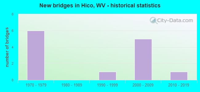
- New bridges - historical statistics
- 61970-1979
- 11990-1999
- 52000-2009
- 12010-2019


- Bridge Condition - Deck
- 9.1%Very good
- 45.5%Good
- 9.1%Satisfactory
- 18.2%Fair
- 18.2%Poor

- Bridge Condition - Superstructure
- 9.1%Very good
- 45.5%Good
- 9.1%Satisfactory
- 27.3%Fair
- 9.1%Poor

- Bridge Condition - Substructure
- 36.4%Good
- 27.3%Satisfactory
- 18.2%Fair
- 18.2%Poor

- Bridge Condition - Channel
- 11.1%Excellent
- 33.3%Very good
- 44.4%Good
- 11.1%Poor
Find on map >> Show street view
Structure Number: 10A014, Location: 0.15 Miles S. of CR 3/5 (Lat: 38.190911, Lng: -81.036919), Route carried "on" structure: County highway 303, Year Built: 1976, Status: Open, Structure Length: 0.85m (2.79ft), Average Daily Traffic: 50 (year 2019), Truck Traffic: 6%, Average Future Daily Traffic: 61 (year 2039), Design Load: H 20, Features Intersected: LAUREL CREEK, Facility Carried by Structure: COUNTY ROUTE 3/3
Minimum Vertical Clearance: 30+ m (98+ ft), Kilometerpoint: 1.336, Lanes on structure: 1, Owner: State Highway Agency, Approaching Roadway Width: 4.9m (16.1ft), Material/Design: Steel, Design/Construction: Stringer/Multi-beam, Number Of Spans In Main Unit: 1, Length of Maximum Span: 7.7m (25.3ft), Curb-To-Curb Width: 4.8m (15.7ft), Out-to-Out Width: 4.9m (16.1ft)
Condition: Deck: Fair, Superstructure: Fair, Substructure: Fair, Channel: Good, Operating Rating: 64.4 metric tons, Method Used To Determine Operating Rating: Load Factor (LF), Inventory Rating: 39.0 metric tons, Method Used To Determine Inventory Rating: Load Factor (LF), Structural Evaluation: Somewhat better than minimum adequacy, Deck Geometry: Equal to present desirable criteria, Waterway Adequacy: Better than present minimum criteria, Approach Roadway Alignment: Equal to present minimum criteria, Length Of Structure Improvement: 1.52m (4.99ft), Designated Inspection Frequency: Every 24 months, Inspection Date: April 2021, Bridge Improvement Cost: $228,000, Roadway Improvement Cost: $127,000, Total Project Cost: $355,000 ( Estimate for 2021), Deck Structure Type: Wood or Timber, Wearing Surface/Protective System: Wearing Surface: Bituminous, Deck Protection: Other
Find on map >> Show street view
Structure Number: 10A015, Location: 0.52 Miles N. of CR 3/5 (Lat: 38.198289, Lng: -81.039661), Route carried "on" structure: County highway 303, Year Built: 1990, Status: Open, Structure Length: 1.17m (3.84ft), Average Daily Traffic: 33 (year 2019), Truck Traffic: 6%, Average Future Daily Traffic: 40 (year 2039), Features Intersected: LAUREL CREEK, Facility Carried by Structure: COUNTY ROUTE 3/3
Minimum Vertical Clearance: 30+ m (98+ ft), Kilometerpoint: 2.414, Lanes on structure: 1, Owner: State Highway Agency, Approaching Roadway Width: 4.3m (14.1ft), Skew: 1 degrees, Material/Design: Steel, Design/Construction: Stringer/Multi-beam, Number Of Spans In Main Unit: 1, Length of Maximum Span: 11.0m (36.1ft), Curb-To-Curb Width: 4.0m (13.1ft), Out-to-Out Width: 4.5m (14.8ft)
Condition: Deck: Fair, Superstructure: Satisfactory, Substructure: Satisfactory, Channel: Very good, Operating Rating: 75.3 metric tons, Method Used To Determine Operating Rating: Load Factor (LF), Inventory Rating: 45.4 metric tons, Method Used To Determine Inventory Rating: Load Factor (LF), Structural Evaluation: Equal to present minimum criteria, Deck Geometry: Somewhat better than minimum adequacy, Waterway Adequacy: Better than present minimum criteria, Approach Roadway Alignment: Better than present minimum criteria, Designated Inspection Frequency: Every 24 months, Inspection Date: May 2021, Deck Structure Type: Wood or Timber, Wearing Surface/Protective System: Deck Protection: Other
Find on map >> Show street view
Structure Number: 10A144, Location: 0.24 Miles E. of CR 4 (Lat: 38.116481, Lng: -81.005131), Route carried "on" structure: US 6000, Year Built: 1970, Status: Open, Structure Length: 8.26m (27.10ft), Average Daily Traffic: 3,300 (year 2019), Truck Traffic: 12%, Average Future Daily Traffic: 4,026 (year 2039), Design Load: HS 20, Features Intersected: US 19 NBL & SBL, Facility Carried by Structure: US 60 EBL
Minimum Vertical Clearance: 30+ m (98+ ft), Kilometerpoint: 42.117, Lanes on structure: 2, Lanes under structure: 5, Owner: State Highway Agency, Approaching Roadway Width: 12.8m (42.0ft), Material/Design: Steel continuous, Design/Construction: Stringer/Multi-beam, Number Of Spans In Main Unit: 2, Number Of Approach Spans: 2, Length of Maximum Span: 31.8m (104.3ft), Curb-To-Curb Width: 12.3m (40.4ft), Out-to-Out Width: 13.6m (44.6ft)
Condition: Deck: Poor, Superstructure: Fair, Substructure: Poor, Operating Rating: 58.0 metric tons, Method Used To Determine Operating Rating: Load Factor (LF), Inventory Rating: 35.4 metric tons, Method Used To Determine Inventory Rating: Load Factor (LF), Structural Evaluation: Meets minimum limits, Deck Geometry: Better than present minimum criteria, Underclear: Equal to present minimum criteria, Approach Roadway Alignment: Equal to present desirable criteria, Length Of Structure Improvement: 8.26m (27.10ft), Designated Inspection Frequency: Every 24 months, Inspection Date: November 2021, Bridge Improvement Cost: $290,000, Roadway Improvement Cost: $10,000, Total Project Cost: $377,000 ( Estimate for 2022), Deck Structure Type: Concrete Cast-file-Place, Wearing Surface/Protective System: Wearing Surface: Latex Concrete
Find on map >> Show street view
Structure Number: 10A145, Location: 0.24 Miles E. of CR 4 (Lat: 38.116600, Lng: -81.004919), Route carried "on" structure: US 6000, Year Built: 1970, Status: Open, Structure Length: 8.26m (27.10ft), Average Daily Traffic: 3,465 (year 2019), Truck Traffic: 12%, Average Future Daily Traffic: 4,227 (year 2039), Design Load: HS 20, Features Intersected: US 19, Facility Carried by Structure: US 60 WBL
Minimum Vertical Clearance: 30+ m (98+ ft), Kilometerpoint: 42.117, Lanes on structure: 2, Lanes under structure: 5, Base Highway Network: Yes, Owner: State Highway Agency, Approaching Roadway Width: 12.8m (42.0ft), Material/Design: Steel continuous, Design/Construction: Stringer/Multi-beam, Number Of Spans In Main Unit: 2, Number Of Approach Spans: 2, Length of Maximum Span: 31.8m (104.3ft), Curb-To-Curb Width: 12.3m (40.4ft), Out-to-Out Width: 13.6m (44.6ft)
Condition: Deck: Poor, Superstructure: Fair, Substructure: Poor, Operating Rating: 58.0 metric tons, Method Used To Determine Operating Rating: Load Factor (LF), Inventory Rating: 35.4 metric tons, Method Used To Determine Inventory Rating: Load Factor (LF), Structural Evaluation: Meets minimum limits, Deck Geometry: Better than present minimum criteria, Underclear: Equal to present minimum criteria, Approach Roadway Alignment: Equal to present desirable criteria, Length Of Structure Improvement: 8.26m (27.10ft), Designated Inspection Frequency: Every 24 months, Inspection Date: November 2021, Bridge Improvement Cost: $290,000, Roadway Improvement Cost: $10,000, Total Project Cost: $377,000 ( Estimate for 2021), Deck Structure Type: Concrete Cast-file-Place, Wearing Surface/Protective System: Wearing Surface: Latex Concrete
Find on map >> Show street view
Structure Number: 10A249, Location: 0.01 Miles S. of CR 85/2 (Lat: 38.040250, Lng: -80.996789), Route carried "on" structure: County highway 8513, Year Built: 1976, Status: Posted for load, Structure Length: 0.82m (2.69ft), Average Daily Traffic: 30 (year 2020), Truck Traffic: 6%, Average Future Daily Traffic: 37 (year 2040), Design Load: HS 20, Features Intersected: KEENEY CREEK, Facility Carried by Structure: COUNTY ROUTE 85/13
Minimum Vertical Clearance: 30+ m (98+ ft), Kilometerpoint: 0.016, Lanes on structure: 2, Owner: State Highway Agency, Approaching Roadway Width: 4.0m (13.1ft), Material/Design: Steel, Design/Construction: Stringer/Multi-beam, Number Of Spans In Main Unit: 1, Length of Maximum Span: 6.8m (22.3ft), Curb-To-Curb Width: 4.9m (16.1ft), Out-to-Out Width: 4.9m (16.1ft)
Condition: Deck: Satisfactory, Superstructure: Poor, Substructure: Fair, Channel: Very good, Operating Rating: 44.4 metric tons, Method Used To Determine Operating Rating: Load Factor (LF), Inventory Rating: 27.2 metric tons, Method Used To Determine Inventory Rating: Load Factor (LF), Structural Evaluation: Meets minimum limits, Deck Geometry: High priority of corrective action, Waterway Adequacy: Superior to present desirable criteria, Approach Roadway Alignment: Equal to present minimum criteria, Length Of Structure Improvement: 1.52m (4.99ft), Designated Inspection Frequency: Every 24 months, Inspection Date: June 2021, Bridge Improvement Cost: $248,000, Roadway Improvement Cost: $140,000, Total Project Cost: $388,000 ( Estimate for 2021), Deck Structure Type: Wood or Timber, Wearing Surface/Protective System: Deck Protection: Other
Find on map >> Show street view
Structure Number: 10A281, Location: 1.60 Miles W. of CR 82 (Lat: 38.034589, Lng: -81.012639), Route carried "on" structure: County highway 8502, Year Built: 2002, Status: Open, Structure Length: 1.01m (3.31ft), Average Daily Traffic: 10 (year 2019), Truck Traffic: 6%, Average Future Daily Traffic: 12 (year 2039), Design Load: HS 25 or greater, Features Intersected: KEENEY'S CREEK, Facility Carried by Structure: COUNTY ROUTE 85/2
Minimum Vertical Clearance: 30+ m (98+ ft), Kilometerpoint: 2.575, Lanes on structure: 2, Owner: State Highway Agency, Approaching Roadway Width: 4.3m (14.1ft), Material/Design: Prestressed concrete, Design/Construction: Box Beam or Girders - Multiple, Number Of Spans In Main Unit: 1, Length of Maximum Span: 9.1m (29.9ft), Curb-To-Curb Width: 5.3m (17.4ft), Out-to-Out Width: 5.6m (18.4ft)
Condition: Deck: Good, Superstructure: Good, Substructure: Satisfactory, Channel: Very good, Operating Rating: 77.1 metric tons, Method Used To Determine Operating Rating: Load Factor (LF), Inventory Rating: 46.3 metric tons, Method Used To Determine Inventory Rating: Load Factor (LF), Structural Evaluation: Equal to present minimum criteria, Deck Geometry: High priority of corrective action, Waterway Adequacy: Superior to present desirable criteria, Approach Roadway Alignment: Meets minimum limits, Designated Inspection Frequency: Every 24 months, Inspection Date: December 2020, Deck Structure Type: Other, Wearing Surface/Protective System: Wearing Surface: Bituminous
Find on map >> Show street view
Structure Number: 10A282, Location: 0.27 Miles S. of CR 82 (Lat: 38.057619, Lng: -81.032469), Route carried "on" structure: County highway 8505, Year Built: 2002, Status: Open, Structure Length: 1.89m (6.20ft), Average Daily Traffic: 55 (year 2019), Truck Traffic: 6%, Average Future Daily Traffic: 67 (year 2039), Design Load: HS 25 or greater, Features Intersected: SHORT CREEK, Facility Carried by Structure: COUNTY ROUTE 85/5
Minimum Vertical Clearance: 30+ m (98+ ft), Kilometerpoint: 4.780, Lanes on structure: 2, Owner: State Highway Agency, Approaching Roadway Width: 3.7m (12.1ft), Material/Design: Prestressed concrete, Design/Construction: Box Beam or Girders - Multiple, Number Of Spans In Main Unit: 1, Length of Maximum Span: 17.8m (58.4ft), Curb-To-Curb Width: 6.9m (22.6ft), Out-to-Out Width: 7.4m (24.3ft)
Condition: Deck: Good, Superstructure: Good, Substructure: Good, Channel: Excellent, Operating Rating: 88.9 metric tons, Method Used To Determine Operating Rating: Load Factor (LF), Inventory Rating: 61.7 metric tons, Method Used To Determine Inventory Rating: Load Factor (LF), Structural Evaluation: Better than present minimum criteria, Deck Geometry: Somewhat better than minimum adequacy, Waterway Adequacy: Superior to present desirable criteria, Approach Roadway Alignment: Somewhat better than minimum adequacy, Designated Inspection Frequency: Every 48 months, Inspection Date: July 2020, Deck Structure Type: Other, Wearing Surface/Protective System: Wearing Surface: Bituminous, Deck Protection: Epoxy Coated Reinforcing
Find on map >> Show street view
Structure Number: 10A283, Location: 1.94 Miles W. of CR 82 (Lat: 38.030461, Lng: -81.015819), Route carried "on" structure: County highway 8502, Year Built: 2002, Status: Open, Structure Length: 1.40m (4.59ft), Average Daily Traffic: 5 (year 2016), Truck Traffic: 6%, Average Future Daily Traffic: 6 (year 2036), Design Load: HS 25 or greater, Features Intersected: KEENEY CREEK, Facility Carried by Structure: COUNTY ROUTE 85/2
Minimum Vertical Clearance: 30+ m (98+ ft), Kilometerpoint: 3.122, Lanes on structure: 1, Owner: State Highway Agency, Approaching Roadway Width: 4.3m (14.1ft), Material/Design: Prestressed concrete, Design/Construction: Box Beam or Girders - Multiple, Number Of Spans In Main Unit: 1, Length of Maximum Span: 13.1m (43.0ft), Curb-To-Curb Width: 4.3m (14.1ft), Out-to-Out Width: 4.6m (15.1ft)
Condition: Deck: Very good, Superstructure: Very good, Substructure: Good, Channel: Good, Operating Rating: 57.1 metric tons, Method Used To Determine Operating Rating: Load Factor (LF), Inventory Rating: 34.5 metric tons, Method Used To Determine Inventory Rating: Load Factor (LF), Structural Evaluation: Better than present minimum criteria, Deck Geometry: Equal to present minimum criteria, Waterway Adequacy: Superior to present desirable criteria, Approach Roadway Alignment: Meets minimum limits, Designated Inspection Frequency: Every 48 months, Inspection Date: May 2018, Deck Structure Type: Other, Wearing Surface/Protective System: Wearing Surface: Bituminous
Find on map >> Show street view
Structure Number: 10A284, Location: 2.17 Miles W. of CR 82 (Lat: 38.031911, Lng: -81.019731), Route carried "on" structure: County highway 8502, Year Built: 2002, Status: Open, Structure Length: 1.02m (3.35ft), Average Daily Traffic: 10 (year 2019), Truck Traffic: 6%, Average Future Daily Traffic: 12 (year 2039), Design Load: HS 25 or greater, Features Intersected: KEENEY CREEK, Facility Carried by Structure: COUNTY ROUTE 85/2
Minimum Vertical Clearance: 30+ m (98+ ft), Kilometerpoint: 3.492, Lanes on structure: 2, Owner: State Highway Agency, Approaching Roadway Width: 4.3m (14.1ft), Material/Design: Steel, Design/Construction: Stringer/Multi-beam, Number Of Spans In Main Unit: 1, Length of Maximum Span: 9.1m (29.9ft), Curb-To-Curb Width: 5.0m (16.4ft), Out-to-Out Width: 5.5m (18.0ft)
Condition: Deck: Good, Superstructure: Good, Substructure: Satisfactory, Channel: Poor, Operating Rating: 88.9 metric tons, Method Used To Determine Operating Rating: Load Factor (LF), Inventory Rating: 86.2 metric tons, Method Used To Determine Inventory Rating: Load Factor (LF), Structural Evaluation: Equal to present minimum criteria, Deck Geometry: High priority of corrective action, Waterway Adequacy: Superior to present desirable criteria, Approach Roadway Alignment: Equal to present minimum criteria, Designated Inspection Frequency: Every 24 months, Inspection Date: November 2020, Deck Structure Type: Wood or Timber, Wearing Surface/Protective System: Deck Protection: Other
Find on map >> Show street view
Structure Number: 10A285, Location: 2.07 Miles W. of WV 82 (Lat: 38.030611, Lng: -81.017961), Route carried "on" structure: County highway 8502, Year Built: 2002, Status: Open, Structure Length: 1.01m (3.31ft), Average Daily Traffic: 10 (year 2019), Truck Traffic: 6%, Average Future Daily Traffic: 12 (year 2039), Design Load: HS 25 or greater, Features Intersected: KEENEY CREEK, Facility Carried by Structure: COUNTY ROUTE 85/2
Minimum Vertical Clearance: 30+ m (98+ ft), Kilometerpoint: 3.331, Lanes on structure: 2, Owner: State Highway Agency, Approaching Roadway Width: 4.3m (14.1ft), Material/Design: Prestressed concrete, Design/Construction: Box Beam or Girders - Multiple, Number Of Spans In Main Unit: 1, Length of Maximum Span: 9.1m (29.9ft), Curb-To-Curb Width: 5.2m (17.1ft), Out-to-Out Width: 5.5m (18.0ft)
Condition: Deck: Good, Superstructure: Good, Substructure: Good, Channel: Good, Operating Rating: 72.6 metric tons, Method Used To Determine Operating Rating: Load Factor (LF), Inventory Rating: 43.5 metric tons, Method Used To Determine Inventory Rating: Load Factor (LF), Structural Evaluation: Better than present minimum criteria, Deck Geometry: High priority of corrective action, Waterway Adequacy: Superior to present desirable criteria, Approach Roadway Alignment: Equal to present minimum criteria, Designated Inspection Frequency: Every 24 months, Inspection Date: October 2020, Deck Structure Type: Other, Wearing Surface/Protective System: Wearing Surface: Bituminous
Find on map >> Show street view
Structure Number: 10A316, Location: 0.01 Miles N.of CR 82 (Lat: 38.049269, Lng: -80.988839), Route carried "on" structure: County highway 825, Year Built: 2016, Status: Open, Structure Length: 0.76m (2.49ft), Average Daily Traffic: 33 (year 2020), Average Future Daily Traffic: 40 (year 2040), Design Load: HL 93, Features Intersected: KEENY CREEK, Facility Carried by Structure: County Route 82/5
Minimum Vertical Clearance: 30+ m (98+ ft), Kilometerpoint: 0.016, Lanes on structure: 1, Owner: State Highway Agency, Approaching Roadway Width: 4.6m (15.1ft), Skew: 2 degrees, Material/Design: Steel, Design/Construction: Stringer/Multi-beam, Number Of Spans In Main Unit: 1, Length of Maximum Span: 7.3m (24.0ft), Curb-To-Curb Width: 4.4m (14.4ft), Out-to-Out Width: 4.4m (14.4ft)
Condition: Deck: Good, Superstructure: Good, Substructure: Good, Channel: Good, Operating Rating: 88.9 metric tons, Method Used To Determine Operating Rating: Load and Resistance Factor (LRFR), Inventory Rating: 77.1 metric tons, Method Used To Determine Inventory Rating: Load and Resistance Factor (LRFR), Structural Evaluation: Better than present minimum criteria, Deck Geometry: Equal to present minimum criteria, Waterway Adequacy: Equal to present desirable criteria, Approach Roadway Alignment: Equal to present desirable criteria, Designated Inspection Frequency: Every 24 months, Inspection Date: November 2020, Deck Structure Type: Wood or Timber, Wearing Surface/Protective System: Deck Protection: Other
Find on map >> Show street view
Structure Number: 10A144, Location: 0.24 Miles E. of CR 4 (Lat: 38.116492, Lng: -81.005083), Route carried "under" structure: US 1900, Year Built: 1970, Structure Length: 0. m, Average Daily Traffic: 13,500 (year 0012), Truck Traffic: 13%, Features Intersected: US 19 NBL & SBL, Facility Carried by Structure: US 60 EBL
Minimum Vertical Clearance: 5.54m (18.18ft), Kilometerpoint: 34.086, Lanes on structure: 2, Lanes under structure: 5, Length of Maximum Span: 31.8m (104.3ft)
Find on map >> Show street view
Structure Number: 10A145, Location: 0.24 Miles E. of CR 4 (Lat: 38.116600, Lng: -81.004928), Route carried "under" structure: US 1900, Year Built: 1970, Structure Length: 0. m, Average Daily Traffic: 13,500 (year 0012), Truck Traffic: 13%, Features Intersected: US 19, Facility Carried by Structure: US 60 WBL
Minimum Vertical Clearance: 4.90m (16.08ft), Kilometerpoint: 34.118, Lanes on structure: 2, Lanes under structure: 5, Length of Maximum Span: 31.8m (104.3ft)