Bridge Statistics for Highlands, New York (NY)
Condition, Traffic, Stress, Structural Evaluation, Project Costs
- National Bridge Inventory (NBI) Statistics
- 16Number of bridges
- 174ft / 52.9mTotal length
- $96,038,000Total costs
- 210,715Total average daily traffic
- 3,129Total average daily truck traffic
- National Bridge Inventory (NBI) Registered Bridges for Highlands
- No street view available for this location
- New bridges - historical statistics
- 31930-1939
- 21940-1949
- 91950-1959
- 21970-1979
- Reconstructed bridges - Historical Statistics
- 11950-1959
- 01960-1969
- 01970-1979
- 11980-1989
- 01990-1999
- 02000-2009
- 12010-2019
- Bridge Condition - Deck
- 12.5%Good
- 87.5%Satisfactory
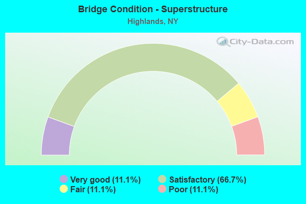
- Bridge Condition - Superstructure
- 11.1%Very good
- 66.7%Satisfactory
- 11.1%Fair
- 11.1%Poor
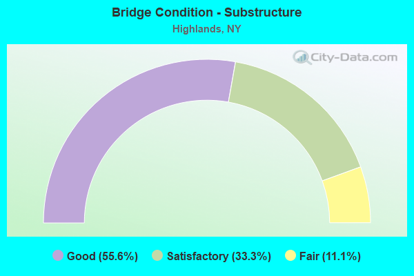
- Bridge Condition - Substructure
- 55.6%Good
- 33.3%Satisfactory
- 11.1%Fair
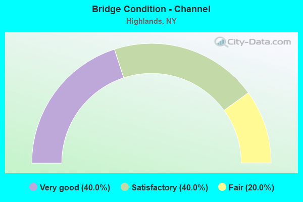
- Bridge Condition - Channel
- 40.0%Very good
- 40.0%Satisfactory
- 20.0%Fair
Find on map >> Show street view
Structure Number: 100338, Location: 0.2 MI E JCT RTE 6+PIP (Lat: 41.306119, Lng: -74.030731), Route carried "on" structure: US 6, Year Built: 1958, Status: Open, Structure Length: 2.13m (6.99ft), Average Daily Traffic: 5,620 (year 2013), Truck Traffic: 1%, Average Future Daily Traffic: 13,481 (year 2040), Design Load: HS 20, Features Intersected: RTE 987C
Minimum Vertical Clearance: 30+ m (98+ ft), Kilometerpoint: 68.817, Lanes on structure: 2, Lanes under structure: 2, Base Highway Network: Yes, Owner: State Park, Forest, or Reservation Agency, Maintenance Responsibility: State Highway Agency, Approaching Roadway Width: 7.3m (24.0ft), Skew: 4 degrees, Material/Design: Concrete, Design/Construction: Frame, Number Of Spans In Main Unit: 1, Length of Maximum Span: 17.9m (58.7ft), Curb-To-Curb Width: 7.3m (24.0ft), Out-to-Out Width: 11.3m (37.1ft)
Condition: Deck: Satisfactory, Superstructure: Satisfactory, Substructure: Good, Operating Rating: 85.4 metric tons, Method Used To Determine Operating Rating: Field evaluation and documented engineering judgment, Inventory Rating: 32.7 metric tons, Method Used To Determine Inventory Rating: Field evaluation and documented engineering judgment, Structural Evaluation: Equal to present minimum criteria, Deck Geometry: High priority of replacement, Underclear: High priority of corrective action, Approach Roadway Alignment: Equal to present desirable criteria, Length Of Structure Improvement: 2.13m (6.99ft), Designated Inspection Frequency: Every 24 months, Inspection Date: May 2021, Bridge Improvement Cost: $1,743,000, Roadway Improvement Cost: $1,021,000, Total Project Cost: $2,764,000 ( Estimate for 2021)
Find on map >> Show street view
Structure Number: 100715, Location: .3 MI N JCT US 9W & US 6 (Lat: 41.323656, Lng: -73.989786), Route carried "on" structure: US 9W, Year Built: 1937, Year Reconstructed: 2017, Status: Open, Structure Length: 18.53m (60.79ft), Average Daily Traffic: 16,129 (year 2019), Truck Traffic: 5%, Average Future Daily Traffic: 16,204 (year 2040), Design Load: HS 20, Features Intersected: POPOLOPEN CREEK
Minimum Vertical Clearance: 30+ m (98+ ft), Kilometerpoint: 0.595, Lanes on structure: 4, Base Highway Network: Yes, Owner: State Highway Agency, Approaching Roadway Width: 13.1m (43.0ft), Material/Design: Steel, Design/Construction: Truss - Deck, Number Of Spans In Main Unit: 3, Length of Maximum Span: 99.4m (326.1ft), Curb or Sidewalk Widths: Left: 1.6m (5.2ft), Right: 1.6m (5.2ft), Curb-To-Curb Width: 13.1m (43.0ft), Out-to-Out Width: 16.5m (54.1ft)
Condition: Deck: Good, Superstructure: Poor, Substructure: Good, Channel: Very good, Operating Rating: 50.8 metric tons, Method Used To Determine Operating Rating: Load Factor (LF), Inventory Rating: 29.9 metric tons, Method Used To Determine Inventory Rating: Load Factor (LF), Structural Evaluation: Meets minimum limits, Deck Geometry: High priority of replacement, Waterway Adequacy: Equal to present desirable criteria, Approach Roadway Alignment: Meets minimum limits, Length Of Structure Improvement: 18.53m (60.79ft), Designated Inspection Frequency: Every 24 months, Critical Feature Inspection Frequency: Every 12 months, Inspection Date: November 2021, Critical Feature Inspection Date: November 2021, Bridge Improvement Cost: $22,042,000, Roadway Improvement Cost: $12,908,000, Total Project Cost: $34,950,000 ( Estimate for 2021), Deck Structure Type: Concrete Cast-file-Place, Wearing Surface/Protective System: Wearing Surface: Integral Concrete, Deck Protection: Epoxy Coated Reinforcing
Find on map >> Show street view
Structure Number: 100716, Location: 0.6 MI N JCT RTS 9W+6 (Lat: 41.327886, Lng: -73.987803), Route carried "on" structure: US 9W, Year Built: 1932, Year Reconstructed: 1986, Status: Open, Structure Length: 15.03m (49.31ft), Average Daily Traffic: 16,129 (year 2019), Truck Traffic: 5%, Average Future Daily Traffic: 16,204 (year 2040), Design Load: HS 20, Features Intersected: OLD MINE ROAD, DOCK BROO
Minimum Vertical Clearance: 30+ m (98+ ft), Kilometerpoint: 1.126, Lanes on structure: 4, Lanes under structure: 2, Base Highway Network: Yes, Owner: State Highway Agency, Approaching Roadway Width: 13.7m (44.9ft), Material/Design: Steel, Design/Construction: Arch - Deck, Number Of Spans In Main Unit: 3, Number Of Approach Spans: 10, Length of Maximum Span: 48.7m (159.8ft), Curb or Sidewalk Widths: Left: 1.2m (3.9ft), Right: 1.2m (3.9ft), Curb-To-Curb Width: 14.1m (46.3ft), Out-to-Out Width: 17.0m (55.8ft)
Condition: Deck: Satisfactory, Superstructure: Satisfactory, Substructure: Satisfactory, Channel: Very good, Operating Rating: 29.0 metric tons, Method Used To Determine Operating Rating: Load Factor (LF), Inventory Rating: 17.2 metric tons, Method Used To Determine Inventory Rating: Load Factor (LF), Structural Evaluation: Meets minimum limits, Deck Geometry: High priority of replacement, Underclear: Meets minimum limits, Waterway Adequacy: Equal to present desirable criteria, Approach Roadway Alignment: Meets minimum limits, Length Of Structure Improvement: 15.02m (49.28ft), Designated Inspection Frequency: Every 24 months, Inspection Date: April 2021, Bridge Improvement Cost: $20,482,000, Roadway Improvement Cost: $11,994,000, Total Project Cost: $32,476,000 ( Estimate for 2021), Deck Structure Type: Concrete Cast-file-Place, Wearing Surface/Protective System: Wearing Surface: Integral Concrete, Deck Protection: Epoxy Coated Reinforcing
Find on map >> Show street view
Structure Number: 1007199, Location: JCT RTS 9W+293 (Lat: 41.387269, Lng: -73.997033), Route carried "on" structure: US 9W, Year Built: 1940, Year Reconstructed: 1964, Status: Open, Structure Length: 1.25m (4.10ft), Average Daily Traffic: 13,013 (year 2020), Truck Traffic: 5%, Average Future Daily Traffic: 13,074 (year 2040), Design Load: HS 20, Features Intersected: RTE 218
Minimum Vertical Clearance: 30+ m (98+ ft), Kilometerpoint: 9.155, Lanes on structure: 4, Lanes under structure: 2, Base Highway Network: Yes, Owner: State Highway Agency, Approaching Roadway Width: 17.1m (56.1ft), Skew: 22 degrees, Material/Design: Concrete, Design/Construction: Frame, Number Of Spans In Main Unit: 1, Length of Maximum Span: 11.2m (36.7ft), Curb-To-Curb Width: 17.1m (56.1ft), Out-to-Out Width: 18.9m (62.0ft)
Condition: Deck: Satisfactory, Superstructure: Satisfactory, Substructure: Satisfactory, Operating Rating: 80.6 metric tons, Method Used To Determine Operating Rating: Field evaluation and documented engineering judgment, Inventory Rating: 32.7 metric tons, Method Used To Determine Inventory Rating: Field evaluation and documented engineering judgment, Structural Evaluation: Equal to present minimum criteria, Deck Geometry: Somewhat better than minimum adequacy, Underclear: Meets minimum limits, Approach Roadway Alignment: Meets minimum limits, Length Of Structure Improvement: 1.24m (4.07ft), Designated Inspection Frequency: Every 24 months, Inspection Date: May 2021, Bridge Improvement Cost: $2,209,000, Roadway Improvement Cost: $1,293,000, Total Project Cost: $3,502,000 ( Estimate for 2021)
Find on map >> Show street view
Structure Number: 104508, Location: 3.0 MI N JCT RTS 293+6 (Lat: 41.349397, Lng: -74.047128), Route carried "on" structure: State highway 293, Year Built: 1959, Status: Open, Structure Length: 0.76m (2.49ft), Average Daily Traffic: 4,045 (year 2018), Truck Traffic: 11%, Average Future Daily Traffic: 4,492 (year 2040), Design Load: HS 20, Features Intersected: MINE LAKE INLET
Minimum Vertical Clearance: 30+ m (98+ ft), Kilometerpoint: 4.907, Lanes on structure: 2, Base Highway Network: Yes, Owner: State Highway Agency, Approaching Roadway Width: 14.0m (45.9ft), Skew: 2 degrees, Material/Design: Concrete, Design/Construction: Arch - Deck, Number Of Spans In Main Unit: 1, Length of Maximum Span: 6.7m (22.0ft), Curb-To-Curb Width: 14.0m (45.9ft), Out-to-Out Width: 22.6m (74.1ft)
Condition: Superstructure: Satisfactory, Substructure: Good, Channel: Satisfactory, Operating Rating: 76.8 metric tons, Method Used To Determine Operating Rating: Field evaluation and documented engineering judgment, Inventory Rating: 29.4 metric tons, Method Used To Determine Inventory Rating: Field evaluation and documented engineering judgment, Structural Evaluation: Equal to present minimum criteria, Deck Geometry: Superior to present desirable criteria, Waterway Adequacy: Meets minimum limits, Approach Roadway Alignment: Equal to present desirable criteria, Length Of Structure Improvement: 0.76m (2.49ft), Designated Inspection Frequency: Every 24 months, Inspection Date: August 2021, Bridge Improvement Cost: $795,000, Roadway Improvement Cost: $466,000, Total Project Cost: $1,261,000 ( Estimate for 2021)
Find on map >> Show street view
Structure Number: 106879, Location: 0.2 MI S JCT PIP+RTE6 (Lat: 41.303406, Lng: -74.032178), Route carried "on" structure: Ramp Other road 987C, Year Built: 1958, Status: Open, Structure Length: 5.12m (16.80ft), Average Daily Traffic: 8,390 (year 2014), Truck Traffic: 1%, Average Future Daily Traffic: 20,126 (year 2040), Design Load: HS 20, Features Intersected: 987C TO/FROM RT 6 NB, 98
Minimum Vertical Clearance: 30+ m (98+ ft), Kilometerpoint: 1.223, Lanes on structure: 2, Lanes under structure: 4, Base Highway Network: Yes, Owner: State Park, Forest, or Reservation Agency, Maintenance Responsibility: State Highway Agency, Approaching Roadway Width: 9.1m (29.9ft), Skew: 4 degrees, Material/Design: Steel, Design/Construction: Stringer/Multi-beam, Number Of Spans In Main Unit: 2, Length of Maximum Span: 25.6m (84.0ft), Curb or Sidewalk Widths: Left: 1.5m (4.9ft), Right: 0.6m (2.0ft), Curb-To-Curb Width: 9.1m (29.9ft), Out-to-Out Width: 12.3m (40.4ft)
Condition: Deck: Satisfactory, Superstructure: Fair, Substructure: Fair, Operating Rating: 75.3 metric tons, Method Used To Determine Operating Rating: Load Factor (LF), Inventory Rating: 44.5 metric tons, Method Used To Determine Inventory Rating: Load Factor (LF), Structural Evaluation: Somewhat better than minimum adequacy, Deck Geometry: Meets minimum limits, Underclear: High priority of corrective action, Approach Roadway Alignment: Meets minimum limits, Length Of Structure Improvement: 5.12m (16.80ft), Designated Inspection Frequency: Every 24 months, Inspection Date: April 2021, Bridge Improvement Cost: $3,868,000, Roadway Improvement Cost: $2,265,000, Total Project Cost: $6,133,000 ( Estimate for 2021), Deck Structure Type: Concrete Cast-file-Place, Wearing Surface/Protective System: Wearing Surface: Bituminous
Find on map >> Show street view
Structure Number: 106894, Location: 0.1 MI W JCT RTE6+PIP (Lat: 41.305622, Lng: -74.035833), Route carried "on" structure: US 6, Year Built: 1958, Status: Open, Structure Length: 1.58m (5.18ft), Average Daily Traffic: 24,565 (year 2018), Truck Traffic: 1%, Average Future Daily Traffic: 24,798 (year 2040), Design Load: HS 20, Features Intersected: QUEENSBORO BROOK
Minimum Vertical Clearance: 30+ m (98+ ft), Kilometerpoint: 68.254, Lanes on structure: 2, Base Highway Network: Yes, Owner: State Park, Forest, or Reservation Agency, Maintenance Responsibility: State Highway Agency, Approaching Roadway Width: 14.0m (45.9ft), Skew: 4 degrees, Material/Design: Concrete continuous, Design/Construction: Culvert, Number Of Spans In Main Unit: 2, Length of Maximum Span: 6.4m (21.0ft)
Condition: Channel: Satisfactory, Culverts: Satisfactory, Operating Rating: 49.6 metric tons, Method Used To Determine Operating Rating: Load and Resistance Factor Rating (LRFR) rating reported by rating factor(RF) method using HL-93 loadings, Inventory Rating: 38.2 metric tons, Method Used To Determine Inventory Rating: Load and Resistance Factor Rating (LRFR) rating reported by rating factor(RF) method using HL-93 loadings, Structural Evaluation: Equal to present minimum criteria, Waterway Adequacy: Somewhat better than minimum adequacy, Approach Roadway Alignment: Equal to present desirable criteria, Length Of Structure Improvement: 1.58m (5.18ft), Designated Inspection Frequency: Every 24 months, Inspection Date: September 2021, Bridge Improvement Cost: $1,861,000, Roadway Improvement Cost: $1,090,000, Total Project Cost: $2,951,000 ( Estimate for 2021)
Find on map >> Show street view
Structure Number: 1091279, Location: 1.0 MI S JCT RTE 9W+293 (Lat: 41.376956, Lng: -73.983289), Route carried "on" structure: Federal lands road , Year Built: 1970, Status: Open, Structure Length: 4.42m (14.50ft), Average Daily Traffic: 490 (year 2020), Truck Traffic: 8%, Average Future Daily Traffic: 492 (year 2040), Design Load: HS 20+Mod, Features Intersected: 9W 9W83021047 SB, RTE 9, Facility Carried by Structure: STONY LONESOME RD
Minimum Vertical Clearance: 30+ m (98+ ft), Kilometerpoint: 0.290, Lanes on structure: 2, Lanes under structure: 5, Owner: State Highway Agency, Approaching Roadway Width: 16.2m (53.1ft), Skew: 30 degrees, Material/Design: Steel, Design/Construction: Stringer/Multi-beam, Number Of Spans In Main Unit: 1, Length of Maximum Span: 42.9m (140.7ft), Curb-To-Curb Width: 16.0m (52.5ft), Out-to-Out Width: 17.2m (56.4ft)
Condition: Deck: Satisfactory, Superstructure: Very good, Substructure: Good, Operating Rating: 74.4 metric tons, Method Used To Determine Operating Rating: Allowable Stress (AS), Inventory Rating: 36.3 metric tons, Method Used To Determine Inventory Rating: Allowable Stress (AS), Structural Evaluation: Better than present minimum criteria, Deck Geometry: Superior to present desirable criteria, Underclear: Somewhat better than minimum adequacy, Approach Roadway Alignment: Equal to present desirable criteria, Length Of Structure Improvement: 4.41m (14.47ft), Designated Inspection Frequency: Every 24 months, Inspection Date: September 2021, Bridge Improvement Cost: $4,085,000, Roadway Improvement Cost: $2,392,000, Total Project Cost: $6,477,000 ( Estimate for 2021), Deck Structure Type: Concrete Cast-file-Place, Wearing Surface/Protective System: Wearing Surface: Integral Concrete, Deck Protection: Epoxy Coated Reinforcing
Find on map >> Show street view
Structure Number: 500339, Location: JCT SEVEN LAKES PKWY&PIP (Lat: 41.309236, Lng: -74.024481), Route carried "on" structure: Other road 987E, Year Built: 1952, Status: Open, Structure Length: 3.05m (10.01ft), Average Daily Traffic: 55 (year 2017), Average Future Daily Traffic: 131 (year 2040), Design Load: HS 20, Features Intersected: 987C 987C83021013 NB, RT
Minimum Vertical Clearance: 30+ m (98+ ft), Kilometerpoint: 0.274, Lanes on structure: 2, Lanes under structure: 4, Owner: State Park, Forest, or Reservation Agency, Maintenance Responsibility: State Highway Agency, Approaching Roadway Width: 11.0m (36.1ft), Skew: 4 degrees, Material/Design: Concrete continuous, Design/Construction: Arch - Deck, Number Of Spans In Main Unit: 2, Length of Maximum Span: 13.1m (43.0ft), Curb or Sidewalk Widths: Left: 1.3m (4.3ft), Right: 1.3m (4.3ft), Curb-To-Curb Width: 11.0m (36.1ft), Out-to-Out Width: 14.9m (48.9ft)
Condition: Deck: Satisfactory, Superstructure: Satisfactory, Substructure: Good, Operating Rating: 80.9 metric tons, Method Used To Determine Operating Rating: Field evaluation and documented engineering judgment, Inventory Rating: 29.4 metric tons, Method Used To Determine Inventory Rating: Field evaluation and documented engineering judgment, Structural Evaluation: Equal to present minimum criteria, Deck Geometry: Superior to present desirable criteria, Underclear: High priority of corrective action, Approach Roadway Alignment: Equal to present desirable criteria, Length Of Structure Improvement: 3.04m (9.97ft), Designated Inspection Frequency: Every 24 months, Inspection Date: June 2021, Bridge Improvement Cost: $3,178,000, Roadway Improvement Cost: $1,861,000, Total Project Cost: $5,038,000 ( Estimate for 2021)
Find on map >> Show street view
Structure Number: 552145, Location: 1.8 MI SW JCT RTS 6+9W (Lat: 41.310786, Lng: -74.024197), Route carried "on" structure: Other road , Year Built: 1955, Status: Open, Structure Length: 1.04m (3.41ft), Truck Traffic: 10%, Features Intersected: QUEENSBORO BROOK, Facility Carried by Structure: TREATMENT PLANT RD
Minimum Vertical Clearance: 30+ m (98+ ft), Kilometerpoint: 0.161, Lanes on structure: 1, Owner: State Park, Forest, or Reservation Agency, Approaching Roadway Width: 3.0m (9.8ft), Material/Design: Steel, Design/Construction: Stringer/Multi-beam, Number Of Spans In Main Unit: 1, Length of Maximum Span: 9.7m (31.8ft), Curb-To-Curb Width: 3.0m (9.8ft), Out-to-Out Width: 4.0m (13.1ft)
Condition: Deck: Satisfactory, Superstructure: Satisfactory, Substructure: Satisfactory, Channel: Fair, Operating Rating: 79.8 metric tons, Method Used To Determine Operating Rating: Load Factor (LF), Inventory Rating: 47.2 metric tons, Method Used To Determine Inventory Rating: Load Factor (LF), Structural Evaluation: Equal to present minimum criteria, Deck Geometry: High priority of replacement, Waterway Adequacy: Meets minimum limits, Approach Roadway Alignment: Equal to present minimum criteria, Length Of Structure Improvement: 1.03m (3.38ft), Designated Inspection Frequency: Every 24 months, Critical Feature Inspection Frequency: Every 24 months, Inspection Date: July 2020, Critical Feature Inspection Date: July 2020, Bridge Improvement Cost: $307,000, Roadway Improvement Cost: $180,000, Total Project Cost: $486,000 ( Estimate for 2021), Deck Structure Type: Concrete Cast-file-Place, Wearing Surface/Protective System: Wearing Surface: Integral Concrete
Find on map >> Show street view
Structure Number: 100338, Location: 0.2 MI E JCT RTE 6+PIP (Lat: 41.306119, Lng: -74.030731), Route carried "under" structure: State lands road 987C, Year Built: 1958, Structure Length: 0. m, Average Daily Traffic: 59,600 (year 2002), Features Intersected: RTE 987C, Facility Carried by Structure: RTE 6
Minimum Vertical Clearance: 4.57m (14.99ft), Kilometerpoint: 12.357, Lanes on structure: 2, Lanes under structure: 2, Material/Design: Concrete, Design/Construction: Frame, Length of Maximum Span: 17.9m (58.7ft)
Find on map >> Show street view
Structure Number: 100716, Location: 0.6 MI N JCT RTS 9W+6 (Lat: 41.327886, Lng: -73.987803), Route carried "under" structure: Other road , Year Built: 1932, Structure Length: 0. m, Average Daily Traffic: 100 (year 1980), Features Intersected: OLD MINE ROAD, DOCK BROO, Facility Carried by Structure: RTE 9W
Minimum Vertical Clearance: 10.99m (36.06ft), Kilometerpoint: 0.000, Lanes on structure: 4, Lanes under structure: 2, Material/Design: Steel, Design/Construction: Arch - Deck, Length of Maximum Span: 48.7m (159.8ft)
Find on map >> Show street view
Structure Number: 1007199, Location: JCT RTS 9W+293 (Lat: 41.387269, Lng: -73.997033), Route carried "under" structure: US 218, Year Built: 1940, Structure Length: 0. m, Average Daily Traffic: 2,359 (year 2002), Features Intersected: RTE 218, Facility Carried by Structure: RTE 9W
Minimum Vertical Clearance: 5.03m (16.50ft), Kilometerpoint: 10.957, Lanes on structure: 4, Lanes under structure: 2, Material/Design: Concrete, Design/Construction: Frame, Length of Maximum Span: 11.2m (36.7ft)
Find on map >> Show street view
Structure Number: 106879, Location: 0.2 MI S JCT PIP+RTE6 (Lat: 41.303406, Lng: -74.032178), Route carried "under" structure: Other road , Year Built: 1958, Structure Length: 0. m, Average Daily Traffic: 35,157 (year 1997), Features Intersected: 987C TO/FROM RT 6 NB, 98, Facility Carried by Structure: RTE 987C
Minimum Vertical Clearance: 4.67m (15.32ft), Kilometerpoint: 0.644, Lanes on structure: 2, Lanes under structure: 2, Material/Design: Steel, Design/Construction: Stringer/Multi-beam, Length of Maximum Span: 25.6m (84.0ft)
Find on map >> Show street view
Structure Number: 1091279, Location: 1.0 MI S JCT RTE 9W+293 (Lat: 41.376956, Lng: -73.983289), Route carried "under" structure: US 9W, Year Built: 1970, Structure Length: 0. m, Average Daily Traffic: 13,963 (year 1999), Features Intersected: 9W 9W83021047 SB, RTE 9, Facility Carried by Structure: STONY LONESOME RD
Minimum Vertical Clearance: 4.50m (14.76ft), Kilometerpoint: 7.273, Lanes on structure: 2, Lanes under structure: 2, Material/Design: Steel, Design/Construction: Stringer/Multi-beam, Length of Maximum Span: 42.9m (140.7ft)
Find on map >> Show street view
Structure Number: 500339, Location: JCT SEVEN LAKES PKWY&PIP (Lat: 41.309236, Lng: -74.024481), Route carried "under" structure: State lands road 987C, Year Built: 1952, Structure Length: 0. m, Average Daily Traffic: 11,100 (year 1979), Features Intersected: 987C 987C83021013 NB, RT, Facility Carried by Structure: RTE 987E
Minimum Vertical Clearance: 4.88m (16.01ft), Kilometerpoint: 55.832, Lanes on structure: 2, Lanes under structure: 2, Material/Design: Concrete continuous, Design/Construction: Arch - Deck, Length of Maximum Span: 13.1m (43.0ft)