Bridge Statistics for Hillsboro, Kansas (KS)
Condition, Traffic, Stress, Structural Evaluation, Project Costs
- National Bridge Inventory (NBI) Statistics
- 30Number of bridges
- 210ft / 63.9mTotal length
- $800,000Total costs
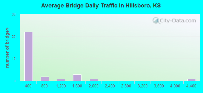
- 13,060Total average daily traffic
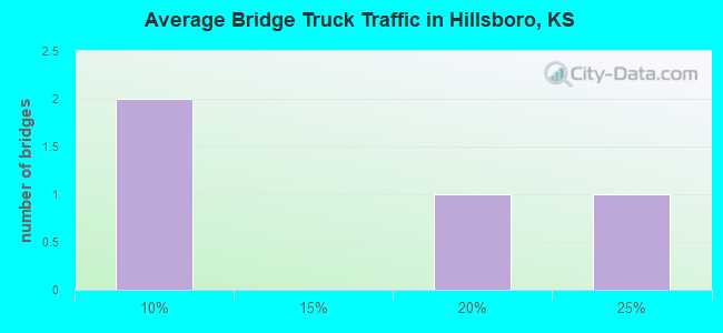
- 1,176Total average daily truck traffic
- 16,514Total future (year 2038) average daily traffic
- National Bridge Inventory (NBI) Registered Bridges for Hillsboro
- No street view available for this location
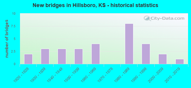
- New bridges - historical statistics
- 21920-1929
- 31930-1939
- 31940-1949
- 31950-1959
- 41960-1969
- 81980-1989
- 41990-1999
- 22000-2009
- 12010-2019
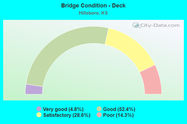
- Bridge Condition - Deck
- 4.8%Very good
- 52.4%Good
- 28.6%Satisfactory
- 14.3%Poor
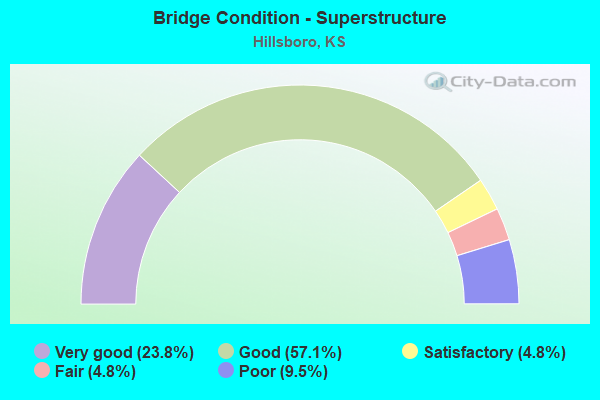
- Bridge Condition - Superstructure
- 23.8%Very good
- 57.1%Good
- 4.8%Satisfactory
- 4.8%Fair
- 9.5%Poor
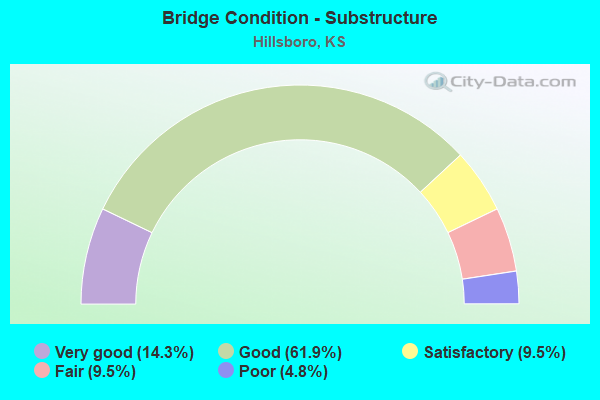
- Bridge Condition - Substructure
- 14.3%Very good
- 61.9%Good
- 9.5%Satisfactory
- 9.5%Fair
- 4.8%Poor
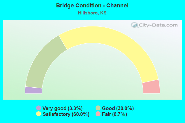
- Bridge Condition - Channel
- 3.3%Very good
- 30.0%Good
- 60.0%Satisfactory
- 6.7%Fair
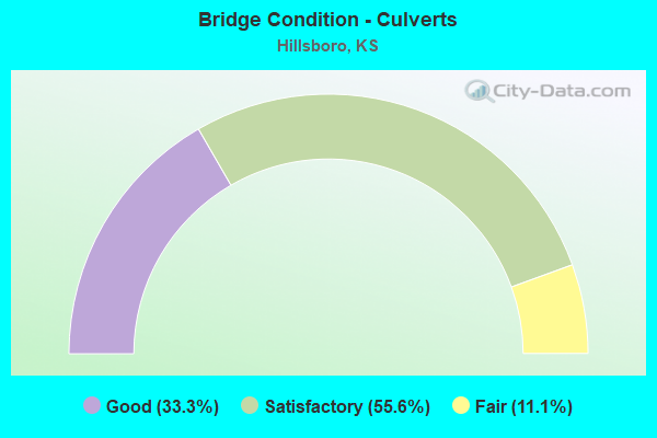
- Bridge Condition - Culverts
- 33.3%Good
- 55.6%Satisfactory
- 11.1%Fair
Find on map >> Show street view
Structure Number: 57019, Location: 4.6S OF HILLSBORO (Lat: 38.281583, Lng: -97.206000), Route carried "on" structure: County highway 422, Year Built: 1967, Status: Posted for load, Structure Length: 1.62m (5.31ft), Average Daily Traffic: 1,080 (year 2011), Average Future Daily Traffic: 1,296 (year 2038), Design Load: H 20, Features Intersected: ANTELOPE CREEK, Facility Carried by Structure: INDIGO RD.
Minimum Vertical Clearance: 30.47m (99.97ft), Kilometerpoint: 0.000, Lanes on structure: 2, Owner: County Highway Agency, Approaching Roadway Width: 13.4m (44.0ft), Material/Design: Concrete, Design/Construction: Culvert, Number Of Spans In Main Unit: 4, Length of Maximum Span: 3.7m (12.1ft), Curb-To-Curb Width: 15.5m (50.9ft), Out-to-Out Width: 16.0m (52.5ft)
Condition: Channel: Good, Culverts: Satisfactory, Operating Rating: 26.1 metric tons, Method Used To Determine Operating Rating: Load Factor (LF), Inventory Rating: 16.2 metric tons, Method Used To Determine Inventory Rating: Load Factor (LF), Structural Evaluation: Meets minimum limits, Deck Geometry: Superior to present desirable criteria, Waterway Adequacy: Equal to present minimum criteria, Approach Roadway Alignment: Equal to present desirable criteria, Designated Inspection Frequency: Every 24 months, Inspection Date: November 2020
Find on map >> Show street view
Structure Number: 5702, Location: 3.2S OF HILLSBORO (Lat: 38.303750, Lng: -97.206056), Route carried "on" structure: County highway 422, Year Built: 1942, Status: Posted for load, Structure Length: 4.27m (14.01ft), Average Daily Traffic: 1,325 (year 2011), Average Future Daily Traffic: 1,590 (year 2038), Features Intersected: SOUTH COTTONWOOD RIVER, Facility Carried by Structure: INDIGO RD.
Minimum Vertical Clearance: 30.47m (99.97ft), Kilometerpoint: 0.000, Lanes on structure: 2, Owner: County Highway Agency, Approaching Roadway Width: 13.4m (44.0ft), Material/Design: Concrete continuous, Design/Construction: Slab, Number Of Spans In Main Unit: 4, Length of Maximum Span: 11.6m (38.1ft), Curb-To-Curb Width: 7.3m (24.0ft), Out-to-Out Width: 8.4m (27.6ft)
Condition: Deck: Satisfactory, Superstructure: Good, Substructure: Good, Channel: Satisfactory, Operating Rating: 38.7 metric tons, Method Used To Determine Operating Rating: Load Factor (LF), Inventory Rating: 23.4 metric tons, Method Used To Determine Inventory Rating: Load Factor (LF), Structural Evaluation: Equal to present minimum criteria, Deck Geometry: Meets minimum limits, Waterway Adequacy: Better than present minimum criteria, Approach Roadway Alignment: Equal to present desirable criteria, Designated Inspection Frequency: Every 24 months, Inspection Date: December 2020, Deck Structure Type: Concrete Cast-file-Place
Find on map >> Show street view
Structure Number: 57021, Location: 2.9S OF HILLSBORO (Lat: 38.306389, Lng: -97.206056), Route carried "on" structure: County highway 422, Year Built: 1967, Status: Posted for load, Structure Length: 1.16m (3.81ft), Average Daily Traffic: 1,325 (year 2011), Average Future Daily Traffic: 1,590 (year 2038), Design Load: H 20, Features Intersected: TRIB. S. COTTONWOOD RIV., Facility Carried by Structure: INDIGO RD.
Minimum Vertical Clearance: 30.47m (99.97ft), Kilometerpoint: 0.000, Lanes on structure: 2, Owner: County Highway Agency, Approaching Roadway Width: 13.4m (44.0ft), Skew: 3 degrees, Material/Design: Concrete, Design/Construction: Culvert, Number Of Spans In Main Unit: 3, Length of Maximum Span: 3.7m (12.1ft), Curb-To-Curb Width: 13.4m (44.0ft), Out-to-Out Width: 13.9m (45.6ft)
Condition: Channel: Good, Culverts: Fair, Operating Rating: 33.3 metric tons, Method Used To Determine Operating Rating: Load Factor (LF), Inventory Rating: 19.8 metric tons, Method Used To Determine Inventory Rating: Load Factor (LF), Structural Evaluation: Somewhat better than minimum adequacy, Deck Geometry: Equal to present desirable criteria, Waterway Adequacy: Equal to present minimum criteria, Approach Roadway Alignment: Equal to present desirable criteria, Designated Inspection Frequency: Every 24 months, Inspection Date: December 2020
Find on map >> Show street view
Structure Number: 57022, Location: 0.9S OF HILLSBORO (Lat: 38.334917, Lng: -97.206056), Route carried "on" structure: County highway 422, Year Built: 1967, Status: Posted for load, Structure Length: 1.16m (3.81ft), Average Daily Traffic: 1,325 (year 2011), Average Future Daily Traffic: 1,590 (year 2038), Design Load: H 20, Features Intersected: TRIB. S. COTTONWOOD RIV., Facility Carried by Structure: INDIGO RD.
Minimum Vertical Clearance: 30.47m (99.97ft), Kilometerpoint: 0.000, Lanes on structure: 2, Owner: County Highway Agency, Approaching Roadway Width: 13.4m (44.0ft), Skew: 3 degrees, Material/Design: Concrete, Design/Construction: Culvert, Number Of Spans In Main Unit: 3, Length of Maximum Span: 3.7m (12.1ft), Curb-To-Curb Width: 13.4m (44.0ft), Out-to-Out Width: 13.9m (45.6ft)
Condition: Channel: Good, Culverts: Satisfactory, Operating Rating: 33.3 metric tons, Method Used To Determine Operating Rating: Load Factor (LF), Inventory Rating: 19.8 metric tons, Method Used To Determine Inventory Rating: Load Factor (LF), Structural Evaluation: Somewhat better than minimum adequacy, Deck Geometry: Equal to present desirable criteria, Waterway Adequacy: Equal to present minimum criteria, Approach Roadway Alignment: Equal to present desirable criteria, Designated Inspection Frequency: Every 24 months, Inspection Date: December 2020
Find on map >> Show street view
Structure Number: 57079, Location: 3.3S 2.0E OF HILLSBORO (Lat: 38.300028, Lng: -97.169250), Route carried "on" structure: County highway 1409, Year Built: 2002, Status: Open, Structure Length: 4.27m (14.01ft), Average Daily Traffic: 235 (year 2011), Average Future Daily Traffic: 282 (year 2038), Design Load: HS 20, Features Intersected: ANTELOPE CREEK, Facility Carried by Structure: KANZA RD.
Minimum Vertical Clearance: 30.47m (99.97ft), Kilometerpoint: 0.000, Lanes on structure: 2, Owner: County Highway Agency, Approaching Roadway Width: 8.5m (27.9ft), Material/Design: Concrete continuous, Design/Construction: Slab, Number Of Spans In Main Unit: 3, Length of Maximum Span: 17.0m (55.8ft), Curb-To-Curb Width: 8.6m (28.2ft), Out-to-Out Width: 9.2m (30.2ft)
Condition: Deck: Good, Superstructure: Very good, Substructure: Very good, Channel: Very good, Operating Rating: 77.1 metric tons, Method Used To Determine Operating Rating: Load Factor (LF), Inventory Rating: 42.3 metric tons, Method Used To Determine Inventory Rating: Load Factor (LF), Structural Evaluation: Equal to present desirable criteria, Deck Geometry: Equal to present minimum criteria, Waterway Adequacy: Equal to present desirable criteria, Approach Roadway Alignment: Equal to present desirable criteria, Designated Inspection Frequency: Every 24 months, Inspection Date: December 2020, Deck Structure Type: Concrete Cast-file-Place
Find on map >> Show street view
Structure Number: 5708, Location: 1.5E 2.2S OF HILLSBORO (Lat: 38.315167, Lng: -97.169250), Route carried "on" structure: County highway 1409, Year Built: 1988, Status: Open, Structure Length: 3.69m (12.11ft), Average Daily Traffic: 275 (year 2011), Average Future Daily Traffic: 330 (year 2038), Design Load: HS 20, Features Intersected: SOUTH COTTONWOOD RIVER, Facility Carried by Structure: KANZA RD.
Minimum Vertical Clearance: 30.47m (99.97ft), Kilometerpoint: 0.000, Lanes on structure: 2, Owner: County Highway Agency, Approaching Roadway Width: 7.9m (25.9ft), Material/Design: Concrete continuous, Design/Construction: Slab, Number Of Spans In Main Unit: 3, Length of Maximum Span: 14.6m (47.9ft), Curb-To-Curb Width: 8.5m (27.9ft), Out-to-Out Width: 9.1m (29.9ft)
Condition: Deck: Very good, Superstructure: Very good, Substructure: Very good, Channel: Satisfactory, Operating Rating: 69.3 metric tons, Method Used To Determine Operating Rating: Load Factor (LF), Inventory Rating: 41.4 metric tons, Method Used To Determine Inventory Rating: Load Factor (LF), Structural Evaluation: Equal to present desirable criteria, Deck Geometry: Equal to present minimum criteria, Waterway Adequacy: Equal to present desirable criteria, Approach Roadway Alignment: Equal to present desirable criteria, Designated Inspection Frequency: Every 24 months, Inspection Date: December 2020, Deck Structure Type: Concrete Cast-file-Place
Find on map >> Show street view
Structure Number: 57081, Location: 0.5S 2.0E OF HILLSBORO (Lat: 38.341139, Lng: -97.169222), Route carried "on" structure: County highway 1409, Year Built: 1949, Status: Posted for load, Structure Length: 0.64m (2.10ft), Average Daily Traffic: 430 (year 2011), Average Future Daily Traffic: 516 (year 2038), Features Intersected: TRIB. S. COTTONWOOD RIV., Facility Carried by Structure: KANZA RD.
Minimum Vertical Clearance: 30.47m (99.97ft), Kilometerpoint: 0.000, Lanes on structure: 2, Owner: County Highway Agency, Approaching Roadway Width: 7.3m (24.0ft), Material/Design: Concrete, Design/Construction: Culvert, Number Of Spans In Main Unit: 2, Length of Maximum Span: 3.0m (9.8ft), Curb-To-Curb Width: 7.7m (25.3ft), Out-to-Out Width: 8.5m (27.9ft)
Condition: Channel: Good, Culverts: Satisfactory, Operating Rating: 38.7 metric tons, Method Used To Determine Operating Rating: Load Factor (LF), Inventory Rating: 23.4 metric tons, Method Used To Determine Inventory Rating: Load Factor (LF), Structural Evaluation: Equal to present minimum criteria, Deck Geometry: Meets minimum limits, Waterway Adequacy: Equal to present minimum criteria, Approach Roadway Alignment: Equal to present desirable criteria, Designated Inspection Frequency: Every 24 months, Inspection Date: December 2020
Find on map >> Show street view
Structure Number: 57082, Location: 2.6N 2.0E OF HILLSBORO (Lat: 38.386167, Lng: -97.169250), Route carried "on" structure: County highway 1409, Year Built: 1966, Status: Posted for load, Structure Length: 4.72m (15.49ft), Average Daily Traffic: 445 (year 2011), Average Future Daily Traffic: 490 (year 2039), Design Load: H 15, Features Intersected: FRENCH CREEK, Facility Carried by Structure: KANZA RD.
Minimum Vertical Clearance: 30.47m (99.97ft), Kilometerpoint: 0.000, Lanes on structure: 2, Owner: County Highway Agency, Approaching Roadway Width: 8.5m (27.9ft), Material/Design: Concrete continuous, Design/Construction: Tee Beam, Number Of Spans In Main Unit: 3, Length of Maximum Span: 18.0m (59.1ft), Curb-To-Curb Width: 7.9m (25.9ft), Out-to-Out Width: 8.3m (27.2ft)
Condition: Deck: Good, Superstructure: Good, Substructure: Good, Channel: Good, Operating Rating: 31.5 metric tons, Method Used To Determine Operating Rating: Load Factor (LF), Inventory Rating: 18.9 metric tons, Method Used To Determine Inventory Rating: Load Factor (LF), Structural Evaluation: Somewhat better than minimum adequacy, Deck Geometry: Somewhat better than minimum adequacy, Waterway Adequacy: Equal to present desirable criteria, Approach Roadway Alignment: Equal to present desirable criteria, Designated Inspection Frequency: Every 24 months, Inspection Date: November 2020, Other Special Inspection Date: September 2021, Deck Structure Type: Concrete Cast-file-Place, Wearing Surface/Protective System: Wearing Surface: Bituminous
Find on map >> Show street view
Structure Number: 87039, Location: 1.0W 2.9N VALLEY CENTER (Lat: 37.880583, Lng: -97.390414), Route carried "on" structure: County highway 611, Year Built: 1989, Status: Open, Structure Length: 4.69m (15.39ft), Average Daily Traffic: 25 (year 2014), Average Future Daily Traffic: 40 (year 2038), Design Load: HS 20, Features Intersected: JESTER CREEK
Minimum Vertical Clearance: 30.47m (99.97ft), Kilometerpoint: 0.000, Lanes on structure: 2, Owner: County Highway Agency, Approaching Roadway Width: 8.5m (27.9ft), Skew: 1 degrees, Material/Design: Prestressed concrete continuous, Design/Construction: Tee Beam, Number Of Spans In Main Unit: 4, Length of Maximum Span: 12.2m (40.0ft), Curb-To-Curb Width: 8.5m (27.9ft), Out-to-Out Width: 9.1m (29.9ft)
Condition: Deck: Satisfactory, Superstructure: Very good, Substructure: Good, Channel: Satisfactory, Operating Rating: 40.5 metric tons, Method Used To Determine Operating Rating: Load Factor (LF), Inventory Rating: 32.4 metric tons, Method Used To Determine Inventory Rating: Load Factor (LF), Structural Evaluation: Better than present minimum criteria, Deck Geometry: Better than present minimum criteria, Waterway Adequacy: Better than present minimum criteria, Approach Roadway Alignment: Better than present minimum criteria, Designated Inspection Frequency: Every 24 months, Inspection Date: August 2021, Deck Structure Type: Concrete Cast-file-Place, Wearing Surface/Protective System: Wearing Surface: Monolithic Concrete, Deck Protection: Epoxy Coated Reinforcing
Find on map >> Show street view
Structure Number: 8704, Location: 1.0W 1.0N VALLEY CENTER (Lat: 37.855958, Lng: -97.389406), Route carried "on" structure: County highway 611, Year Built: 1957, Status: Open, Structure Length: 4.02m (13.19ft), Average Daily Traffic: 45 (year 2018), Average Future Daily Traffic: 70 (year 2038), Design Load: H 20, Features Intersected: BIG DITCH FLOODWAY
Minimum Vertical Clearance: 30.47m (99.97ft), Kilometerpoint: 0.000, Lanes on structure: 2, Owner: County Highway Agency, Approaching Roadway Width: 9.1m (29.9ft), Skew: 2 degrees, Material/Design: Prestressed concrete, Design/Construction: Stringer/Multi-beam, Number Of Spans In Main Unit: 3, Length of Maximum Span: 13.4m (44.0ft), Curb-To-Curb Width: 7.9m (25.9ft), Out-to-Out Width: 8.8m (28.9ft)
Condition: Deck: Satisfactory, Superstructure: Very good, Substructure: Good, Channel: Good, Operating Rating: 27.9 metric tons, Method Used To Determine Operating Rating: Load Factor (LF), Inventory Rating: 22.5 metric tons, Method Used To Determine Inventory Rating: Load Factor (LF), Structural Evaluation: Equal to present minimum criteria, Deck Geometry: Equal to present minimum criteria, Waterway Adequacy: Equal to present desirable criteria, Approach Roadway Alignment: Equal to present minimum criteria, Designated Inspection Frequency: Every 24 months, Inspection Date: August 2021, Deck Structure Type: Concrete Cast-file-Place, Wearing Surface/Protective System: Wearing Surface: Monolithic Concrete
Find on map >> Show street view
Structure Number: 570829005288, Location: 2.5W 0.8S OF HILLSBORO (Lat: 38.337583, Lng: -97.261194), Route carried "on" structure: County highway 5707, Year Built: 1950, Status: Posted for load, Structure Length: 0.64m (2.10ft), Average Daily Traffic: 40 (year 2011), Average Future Daily Traffic: 48 (year 2038), Features Intersected: TRIB. S. COTTONWOOD RIV., Facility Carried by Structure: FALCON RD.
Minimum Vertical Clearance: 30.47m (99.97ft), Kilometerpoint: 0.000, Lanes on structure: 2, Owner: County Highway Agency, Approaching Roadway Width: 7.3m (24.0ft), Material/Design: Concrete, Design/Construction: Culvert, Number Of Spans In Main Unit: 2, Length of Maximum Span: 3.0m (9.8ft), Curb-To-Curb Width: 7.3m (24.0ft), Out-to-Out Width: 8.1m (26.6ft)
Condition: Channel: Satisfactory, Culverts: Good, Operating Rating: 38.7 metric tons, Method Used To Determine Operating Rating: Load Factor (LF), Inventory Rating: 23.4 metric tons, Method Used To Determine Inventory Rating: Load Factor (LF), Structural Evaluation: Equal to present minimum criteria, Deck Geometry: Equal to present minimum criteria, Waterway Adequacy: Equal to present minimum criteria, Approach Roadway Alignment: Equal to present desirable criteria, Designated Inspection Frequency: Every 24 months, Inspection Date: November 2020, Other Special Inspection Date: September 2021
Find on map >> Show street view
Structure Number: 570829005304, Location: 2.5W 0.9S OF HILLSBORO (Lat: 38.328306, Lng: -97.261250), Route carried "on" structure: County highway 5707, Year Built: 1955, Status: Posted for load, Structure Length: 0.91m (2.99ft), Average Daily Traffic: 40 (year 2013), Average Future Daily Traffic: 48 (year 2038), Features Intersected: TRIB. S. COTTONWOOD RIV., Facility Carried by Structure: FALCON RD.
Minimum Vertical Clearance: 30.47m (99.97ft), Kilometerpoint: 0.000, Lanes on structure: 2, Owner: County Highway Agency, Approaching Roadway Width: 7.3m (24.0ft), Material/Design: Steel, Design/Construction: Stringer/Multi-beam, Number Of Spans In Main Unit: 1, Length of Maximum Span: 8.8m (28.9ft), Curb-To-Curb Width: 7.3m (24.0ft), Out-to-Out Width: 7.6m (24.9ft)
Condition: Deck: Satisfactory, Superstructure: Satisfactory, Substructure: Satisfactory, Channel: Satisfactory, Operating Rating: 18.9 metric tons, Method Used To Determine Operating Rating: Load Factor (LF), Inventory Rating: 11.2 metric tons, Method Used To Determine Inventory Rating: Load Factor (LF), Structural Evaluation: Meets minimum limits, Deck Geometry: Equal to present minimum criteria, Waterway Adequacy: Equal to present minimum criteria, Approach Roadway Alignment: Equal to present desirable criteria, Bridge Posting: Required (Relationship of Operating Rating to Maximum Legal Load: 20.0 - 29.9% below), Designated Inspection Frequency: Every 24 months, Inspection Date: December 2020, Deck Structure Type: Concrete Cast-file-Place, Wearing Surface/Protective System: Wearing Surface: Gravel
Find on map >> Show street view
Structure Number: 570829005323, Location: 2.3S 3.0W OF HILLSBORO (Lat: 38.314917, Lng: -97.261250), Route carried "on" structure: County highway 5707, Year Built: 1981, Status: Open, Structure Length: 3.35m (10.99ft), Average Daily Traffic: 40 (year 2013), Average Future Daily Traffic: 48 (year 2038), Features Intersected: SOUTH COTTONWOOD RIVER, Facility Carried by Structure: FALCON RD.
Minimum Vertical Clearance: 30.47m (99.97ft), Kilometerpoint: 0.000, Lanes on structure: 2, Owner: County Highway Agency, Approaching Roadway Width: 7.3m (24.0ft), Material/Design: Prestressed concrete continuous, Design/Construction: Tee Beam, Number Of Spans In Main Unit: 3, Length of Maximum Span: 11.0m (36.1ft), Curb-To-Curb Width: 7.3m (24.0ft), Out-to-Out Width: 7.9m (25.9ft)
Condition: Deck: Satisfactory, Superstructure: Very good, Substructure: Good, Channel: Satisfactory, Operating Rating: 51.3 metric tons, Method Used To Determine Operating Rating: Load Factor (LF), Inventory Rating: 32.4 metric tons, Method Used To Determine Inventory Rating: Load Factor (LF), Structural Evaluation: Better than present minimum criteria, Deck Geometry: Equal to present minimum criteria, Waterway Adequacy: Equal to present desirable criteria, Approach Roadway Alignment: Equal to present desirable criteria, Designated Inspection Frequency: Every 24 months, Inspection Date: December 2020, Deck Structure Type: Other
Find on map >> Show street view
Structure Number: 5708291053, Location: 0.5S 2.9W OF HILLSBORO (Lat: 38.333472, Lng: -97.260250), Route carried "on" structure: County highway , Year Built: 1930, Status: Posted for load, Structure Length: 0.64m (2.10ft), Average Daily Traffic: 40 (year 2013), Average Future Daily Traffic: 48 (year 2038), Features Intersected: TRIB. S. COTTONWOOD RIV., Facility Carried by Structure: 180 RD.
Minimum Vertical Clearance: 30.47m (99.97ft), Kilometerpoint: 0.000, Lanes on structure: 2, Owner: County Highway Agency, Approaching Roadway Width: 6.7m (22.0ft), Material/Design: Concrete, Design/Construction: Culvert, Number Of Spans In Main Unit: 2, Length of Maximum Span: 3.0m (9.8ft), Curb-To-Curb Width: 6.4m (21.0ft), Out-to-Out Width: 6.9m (22.6ft)
Condition: Channel: Good, Culverts: Satisfactory, Operating Rating: 38.7 metric tons, Method Used To Determine Operating Rating: Load Factor (LF), Inventory Rating: 23.4 metric tons, Method Used To Determine Inventory Rating: Load Factor (LF), Structural Evaluation: Equal to present minimum criteria, Deck Geometry: Somewhat better than minimum adequacy, Waterway Adequacy: Somewhat better than minimum adequacy, Approach Roadway Alignment: Equal to present desirable criteria, Designated Inspection Frequency: Every 24 months, Inspection Date: December 2020
Find on map >> Show street view
Structure Number: 570831005208, Location: 1.5W 3.1N OF HILLSBORO (Lat: 38.393419, Lng: -97.243031), Route carried "on" structure: County highway 678, Year Built: 2018, Status: Open, Structure Length: 0.91m (2.99ft), Average Daily Traffic: 35 (year 2011), Average Future Daily Traffic: 50 (year 2039), Design Load: HS 20, Features Intersected: FRENCH CREEK, Facility Carried by Structure: GOLDENROD RD.
Minimum Vertical Clearance: 30.47m (99.97ft), Kilometerpoint: 0.000, Lanes on structure: 2, Owner: County Highway Agency, Approaching Roadway Width: 8.5m (27.9ft), Material/Design: Steel, Design/Construction: Culvert, Number Of Spans In Main Unit: 3, Length of Maximum Span: 2.7m (8.9ft), Curb-To-Curb Width: 8.5m (27.9ft), Out-to-Out Width: 10.7m (35.1ft)
Condition: Channel: Good, Culverts: Good, Operating Rating: 54.4 metric tons, Method Used To Determine Operating Rating: Field evaluation and documented engineering judgment, Inventory Rating: 32.7 metric tons, Method Used To Determine Inventory Rating: Field evaluation and documented engineering judgment, Structural Evaluation: Better than present minimum criteria, Deck Geometry: Better than present minimum criteria, Waterway Adequacy: Equal to present minimum criteria, Approach Roadway Alignment: Equal to present desirable criteria, Designated Inspection Frequency: Every 24 months, Inspection Date: January 2021
Find on map >> Show street view
Structure Number: 570831005324, Location: 1.5W 2.0S OF HILLSBORO (Lat: 38.312694, Lng: -97.242833), Route carried "on" structure: County highway , Year Built: 1930, Status: Posted for load, Structure Length: 1.58m (5.18ft), Average Daily Traffic: 20 (year 2011), Average Future Daily Traffic: 25 (year 2041), Features Intersected: S. COTTONWOOD RIVER, Facility Carried by Structure: GOLDENROD RD.
Minimum Vertical Clearance: 30.47m (99.97ft), Kilometerpoint: 0.000, Lanes on structure: 2, Owner: County Highway Agency, Approaching Roadway Width: 6.7m (22.0ft), Material/Design: Steel, Design/Construction: Truss - Thru, Number Of Spans In Main Unit: 1, Length of Maximum Span: 15.2m (49.9ft), Curb-To-Curb Width: 5.1m (16.7ft), Out-to-Out Width: 5.4m (17.7ft)
Condition: Deck: Poor, Superstructure: Poor, Substructure: Satisfactory, Channel: Satisfactory, Operating Rating: 35.9 metric tons, Method Used To Determine Operating Rating: Load Factor (LF), Inventory Rating: 21.6 metric tons, Method Used To Determine Inventory Rating: Load Factor (LF), Structural Evaluation: Meets minimum limits, Deck Geometry: High priority of corrective action, Waterway Adequacy: Meets minimum limits, Approach Roadway Alignment: Better than present minimum criteria, Length Of Structure Improvement: 2.43m (7.97ft), Designated Inspection Frequency: Every 24 months, Critical Feature Inspection Frequency: Every 24 months, Inspection Date: December 2020, Critical Feature Inspection Date: August 2021, Bridge Improvement Cost: $210,000, Roadway Improvement Cost: $100,000, Total Project Cost: $320,000 ( Estimate for 2014), Deck Structure Type: Concrete Cast-file-Place
Find on map >> Show street view
Structure Number: 57083130522, Location: 1.7W 2.2N OF HILLSBORO (Lat: 38.391611, Lng: -97.236694), Route carried "on" structure: County highway 5718, Year Built: 1987, Status: Posted for load, Structure Length: 0.78m (2.56ft), Average Daily Traffic: 40 (year 2011), Truck Traffic: 5%, Average Future Daily Traffic: 48 (year 2038), Features Intersected: FRENCH CREEK, Facility Carried by Structure: 220 RD.
Minimum Vertical Clearance: 30.47m (99.97ft), Kilometerpoint: 0.000, Lanes on structure: 2, Owner: County Highway Agency, Approaching Roadway Width: 7.0m (23.0ft), Material/Design: Steel, Design/Construction: Stringer/Multi-beam, Number Of Spans In Main Unit: 1, Length of Maximum Span: 7.4m (24.3ft), Curb-To-Curb Width: 7.3m (24.0ft), Out-to-Out Width: 7.4m (24.3ft)
Condition: Deck: Good, Superstructure: Good, Substructure: Good, Channel: Satisfactory, Operating Rating: 41.6 metric tons, Method Used To Determine Operating Rating: Load Factor (LF), Inventory Rating: 24.9 metric tons, Method Used To Determine Inventory Rating: Load Factor (LF), Structural Evaluation: Equal to present minimum criteria, Deck Geometry: Equal to present minimum criteria, Waterway Adequacy: Equal to present minimum criteria, Approach Roadway Alignment: Equal to present desirable criteria, Designated Inspection Frequency: Every 24 months, Inspection Date: December 2020, Deck Structure Type: Corrugated Steel, Wearing Surface/Protective System: Wearing Surface: Bituminous
Find on map >> Show street view
Structure Number: 57083150532, Location: 1.5S 1.5W OF HILLSBORO (Lat: 38.318889, Lng: -97.234167), Route carried "on" structure: County highway , Year Built: 1935, Status: Posted for load, Structure Length: 0.82m (2.69ft), Average Daily Traffic: 40 (year 2013), Average Future Daily Traffic: 48 (year 2038), Features Intersected: TRIB. S. COTTONWOOD RIV., Facility Carried by Structure: 170 RD.
Minimum Vertical Clearance: 30.47m (99.97ft), Kilometerpoint: 0.000, Lanes on structure: 2, Owner: County Highway Agency, Approaching Roadway Width: 7.3m (24.0ft), Material/Design: Concrete, Design/Construction: Culvert, Number Of Spans In Main Unit: 3, Length of Maximum Span: 2.4m (7.9ft), Curb-To-Curb Width: 7.4m (24.3ft), Out-to-Out Width: 8.2m (26.9ft)
Condition: Channel: Fair, Culverts: Satisfactory, Operating Rating: 47.7 metric tons, Method Used To Determine Operating Rating: Load Factor (LF), Inventory Rating: 28.8 metric tons, Method Used To Determine Inventory Rating: Load Factor (LF), Structural Evaluation: Equal to present minimum criteria, Deck Geometry: Equal to present minimum criteria, Waterway Adequacy: Equal to present minimum criteria, Approach Roadway Alignment: Equal to present desirable criteria, Designated Inspection Frequency: Every 24 months, Inspection Date: December 2020, Other Special Inspection Date: September 2021
Find on map >> Show street view
Structure Number: 570833005327, Location: 0.5W 2.7S OF HILLSBORO (Lat: 38.308028, Lng: -97.224417), Route carried "on" structure: County highway , Year Built: 1987, Status: Open, Structure Length: 4.18m (13.71ft), Average Daily Traffic: 35 (year 2013), Average Future Daily Traffic: 42 (year 2038), Design Load: HS 20, Features Intersected: SOUTH COTTONWOOD RIVER, Facility Carried by Structure: HOLLY RD.
Minimum Vertical Clearance: 30.47m (99.97ft), Kilometerpoint: 0.000, Lanes on structure: 2, Owner: County Highway Agency, Approaching Roadway Width: 10.4m (34.1ft), Skew: 3 degrees, Material/Design: Concrete continuous, Design/Construction: Slab, Number Of Spans In Main Unit: 3, Length of Maximum Span: 16.2m (53.1ft), Curb-To-Curb Width: 7.3m (24.0ft), Out-to-Out Width: 7.9m (25.9ft)
Condition: Deck: Good, Superstructure: Good, Substructure: Good, Channel: Satisfactory, Operating Rating: 71.5 metric tons, Method Used To Determine Operating Rating: Load Factor (LF), Inventory Rating: 42.8 metric tons, Method Used To Determine Inventory Rating: Load Factor (LF), Structural Evaluation: Better than present minimum criteria, Deck Geometry: Equal to present minimum criteria, Waterway Adequacy: Equal to present desirable criteria, Approach Roadway Alignment: Equal to present desirable criteria, Designated Inspection Frequency: Every 24 months, Inspection Date: December 2020, Deck Structure Type: Concrete Cast-file-Place
Find on map >> Show street view
Structure Number: 57083360534, Location: 2.5S 0.4W OF HILLSBORO (Lat: 38.304389, Lng: -97.214611), Route carried "on" structure: County highway , Year Built: 1920, Status: Posted for load, Structure Length: 0.85m (2.79ft), Average Daily Traffic: 25 (year 2013), Average Future Daily Traffic: 32 (year 2038), Features Intersected: SOUTH COTTONWOOD RIVER, Facility Carried by Structure: 160 RD.
Minimum Vertical Clearance: 30.47m (99.97ft), Kilometerpoint: 0.000, Lanes on structure: 2, Owner: County Highway Agency, Approaching Roadway Width: 4.9m (16.1ft), Material/Design: Concrete, Design/Construction: Slab, Number Of Spans In Main Unit: 2, Length of Maximum Span: 4.0m (13.1ft), Curb-To-Curb Width: 5.2m (17.1ft), Out-to-Out Width: 5.9m (19.4ft)
Condition: Deck: Poor, Superstructure: Fair, Substructure: Fair, Channel: Fair, Operating Rating: 7.2 metric tons, Method Used To Determine Operating Rating: Load Factor (LF), Inventory Rating: 4.5 metric tons, Method Used To Determine Inventory Rating: Load Factor (LF), Structural Evaluation: High priority of replacement, Deck Geometry: High priority of corrective action, Waterway Adequacy: Somewhat better than minimum adequacy, Approach Roadway Alignment: Equal to present desirable criteria, Bridge Posting: Required (Relationship of Operating Rating to Maximum Legal Load: > 39.9% below), Length Of Structure Improvement: 1.46m (4.79ft), Designated Inspection Frequency: Every 24 months, Inspection Date: December 2020, Bridge Improvement Cost: $130,000, Roadway Improvement Cost: $100,000, Total Project Cost: $240,000 ( Estimate for 2014), Deck Structure Type: Concrete Cast-file-Place, Wearing Surface/Protective System: Wearing Surface: Other
Find on map >> Show street view
Structure Number: 570835005229, Location: 1.4N OF HILLSBORO (Lat: 38.379000, Lng: -97.206167), Route carried "on" structure: County highway , Year Built: 1980, Status: Posted for load, Structure Length: 2.99m (9.81ft), Average Daily Traffic: 45 (year 2011), Average Future Daily Traffic: 54 (year 2038), Design Load: H 20, Features Intersected: FRENCH CREEK, Facility Carried by Structure: INDIGO RD.
Minimum Vertical Clearance: 30.47m (99.97ft), Kilometerpoint: 0.000, Lanes on structure: 2, Owner: County Highway Agency, Approaching Roadway Width: 8.5m (27.9ft), Material/Design: Concrete continuous, Design/Construction: Slab, Number Of Spans In Main Unit: 3, Length of Maximum Span: 11.6m (38.1ft), Curb-To-Curb Width: 7.3m (24.0ft), Out-to-Out Width: 7.9m (25.9ft)
Condition: Deck: Good, Superstructure: Good, Substructure: Very good, Channel: Satisfactory, Operating Rating: 47.9 metric tons, Method Used To Determine Operating Rating: Load Factor (LF), Inventory Rating: 28.7 metric tons, Method Used To Determine Inventory Rating: Load Factor (LF), Structural Evaluation: Better than present minimum criteria, Deck Geometry: Equal to present minimum criteria, Waterway Adequacy: Better than present minimum criteria, Approach Roadway Alignment: Equal to present desirable criteria, Designated Inspection Frequency: Every 24 months, Inspection Date: November 2020, Deck Structure Type: Concrete Cast-file-Place
Find on map >> Show street view
Structure Number: 570837005228, Location: 0.3E 1.4N OF HILLSBORO (Lat: 38.379972, Lng: -97.187667), Route carried "on" structure: County highway , Year Built: 1989, Status: Posted for load, Structure Length: 2.07m (6.79ft), Average Daily Traffic: 40 (year 2011), Average Future Daily Traffic: 48 (year 2039), Features Intersected: FRENCH CREEK, Facility Carried by Structure: JADE RD.
Minimum Vertical Clearance: 30.47m (99.97ft), Kilometerpoint: 0.000, Lanes on structure: 2, Owner: County Highway Agency, Approaching Roadway Width: 8.5m (27.9ft), Material/Design: Steel, Design/Construction: Stringer/Multi-beam, Number Of Spans In Main Unit: 3, Length of Maximum Span: 7.0m (23.0ft), Curb-To-Curb Width: 8.5m (27.9ft), Out-to-Out Width: 8.7m (28.5ft)
Condition: Deck: Good, Superstructure: Good, Substructure: Good, Channel: Satisfactory, Operating Rating: 83.7 metric tons, Method Used To Determine Operating Rating: Load Factor (LF), Inventory Rating: 61.2 metric tons, Method Used To Determine Inventory Rating: Load Factor (LF), Structural Evaluation: Better than present minimum criteria, Deck Geometry: Better than present minimum criteria, Waterway Adequacy: Somewhat better than minimum adequacy, Approach Roadway Alignment: Equal to present desirable criteria, Designated Inspection Frequency: Every 24 months, Inspection Date: November 2020, Deck Structure Type: Open Grating, Wearing Surface/Protective System: Wearing Surface: Other
Find on map >> Show street view
Structure Number: 570837005324, Location: 0.3E 2.4S OF HILLSBORO (Lat: 38.312861, Lng: -97.187611), Route carried "on" structure: County highway , Year Built: 1996, Status: Open, Structure Length: 1.55m (5.09ft), Average Daily Traffic: 20 (year 2011), Average Future Daily Traffic: 25 (year 2039), Design Load: HS 20, Features Intersected: SOUTH COTTONWOOD RIVER, Facility Carried by Structure: JADE RD.
Minimum Vertical Clearance: 30.47m (99.97ft), Kilometerpoint: 0.000, Lanes on structure: 2, Owner: County Highway Agency, Approaching Roadway Width: 6.1m (20.0ft), Material/Design: Steel, Design/Construction: Stringer/Multi-beam, Number Of Spans In Main Unit: 1, Length of Maximum Span: 15.2m (49.9ft), Curb-To-Curb Width: 7.7m (25.3ft), Out-to-Out Width: 7.9m (25.9ft)
Condition: Deck: Good, Superstructure: Good, Substructure: Good, Channel: Satisfactory, Operating Rating: 47.7 metric tons, Method Used To Determine Operating Rating: Allowable Stress (AS), Inventory Rating: 33.3 metric tons, Method Used To Determine Inventory Rating: Allowable Stress (AS), Structural Evaluation: Better than present minimum criteria, Deck Geometry: Equal to present minimum criteria, Waterway Adequacy: Equal to present minimum criteria, Approach Roadway Alignment: Equal to present desirable criteria, Designated Inspection Frequency: Every 24 months, Inspection Date: December 2020, Deck Structure Type: Corrugated Steel, Wearing Surface/Protective System: Wearing Surface: Bituminous
Find on map >> Show street view
Structure Number: 57083760536, Location: 8.1W 3.5S OF MARION (Lat: 38.289889, Lng: -97.175889), Route carried "on" structure: County highway , Year Built: 1995, Status: Open, Structure Length: 1.23m (4.04ft), Average Daily Traffic: 60 (year 2011), Truck Traffic: 5%, Average Future Daily Traffic: 72 (year 2038), Features Intersected: ANTELOPE CREEK, Facility Carried by Structure: 150 RD.
Minimum Vertical Clearance: 30.47m (99.97ft), Kilometerpoint: 0.000, Lanes on structure: 2, Owner: County Highway Agency, Approaching Roadway Width: 7.3m (24.0ft), Material/Design: Steel, Design/Construction: Stringer/Multi-beam, Number Of Spans In Main Unit: 1, Length of Maximum Span: 11.9m (39.0ft), Curb-To-Curb Width: 7.7m (25.3ft), Out-to-Out Width: 7.9m (25.9ft)
Condition: Deck: Good, Superstructure: Good, Substructure: Good, Channel: Satisfactory, Operating Rating: 40.6 metric tons, Method Used To Determine Operating Rating: Load Factor (LF), Inventory Rating: 24.3 metric tons, Method Used To Determine Inventory Rating: Load Factor (LF), Structural Evaluation: Equal to present minimum criteria, Deck Geometry: Equal to present minimum criteria, Waterway Adequacy: Equal to present minimum criteria, Approach Roadway Alignment: Equal to present desirable criteria, Designated Inspection Frequency: Every 24 months, Inspection Date: November 2020, Deck Structure Type: Corrugated Steel, Wearing Surface/Protective System: Wearing Surface: Bituminous
Find on map >> Show street view
Structure Number: 57083910534, Location: 2.5S 2.1E OF HILLSBORO (Lat: 38.304472, Lng: -97.167111), Route carried "on" structure: County highway , Year Built: 1920, Status: Posted for load, Structure Length: 0.85m (2.79ft), Average Daily Traffic: 40 (year 2011), Average Future Daily Traffic: 48 (year 2038), Features Intersected: ANTELOPE CREEK, Facility Carried by Structure: 160 RD.
Minimum Vertical Clearance: 30.47m (99.97ft), Kilometerpoint: 0.000, Lanes on structure: 2, Owner: County Highway Agency, Approaching Roadway Width: 6.7m (22.0ft), Material/Design: Concrete, Design/Construction: Tee Beam, Number Of Spans In Main Unit: 1, Length of Maximum Span: 8.2m (26.9ft), Curb-To-Curb Width: 5.4m (17.7ft), Out-to-Out Width: 6.3m (20.7ft)
Condition: Deck: Poor, Superstructure: Poor, Substructure: Poor, Channel: Satisfactory, Operating Rating: 22.5 metric tons, Method Used To Determine Operating Rating: Load Factor (LF), Inventory Rating: 13.5 metric tons, Method Used To Determine Inventory Rating: Load Factor (LF), Structural Evaluation: Meets minimum limits, Deck Geometry: High priority of corrective action, Waterway Adequacy: Equal to present minimum criteria, Approach Roadway Alignment: Equal to present desirable criteria, Bridge Posting: Required (Relationship of Operating Rating to Maximum Legal Load: 30.0 - 39.9% below), Length Of Structure Improvement: 1.46m (4.79ft), Designated Inspection Frequency: Every 24 months, Inspection Date: December 2020, Bridge Improvement Cost: $130,000, Roadway Improvement Cost: $100,000, Total Project Cost: $240,000 ( Estimate for 2014), Deck Structure Type: Concrete Cast-file-Place, Wearing Surface/Protective System: Wearing Surface: Gravel
Find on map >> Show street view
Structure Number: 570841005307, Location: 2.3E 1.7S OF HILLSBORO (Lat: 38.323583, Lng: -97.150778), Route carried "on" structure: County highway , Year Built: 1994, Status: Open, Structure Length: 1.25m (4.10ft), Average Daily Traffic: 30 (year 2011), Average Future Daily Traffic: 35 (year 2038), Design Load: HS 20, Features Intersected: SOUTH COTTONWOOD RIVER, Facility Carried by Structure: LIMESTONE RD.
Minimum Vertical Clearance: 30.47m (99.97ft), Kilometerpoint: 0.000, Lanes on structure: 2, Owner: County Highway Agency, Approaching Roadway Width: 7.3m (24.0ft), Material/Design: Steel, Design/Construction: Stringer/Multi-beam, Number Of Spans In Main Unit: 1, Length of Maximum Span: 12.5m (41.0ft), Curb-To-Curb Width: 7.4m (24.3ft), Out-to-Out Width: 7.9m (25.9ft)
Condition: Deck: Good, Superstructure: Good, Substructure: Good, Channel: Satisfactory, Operating Rating: 66.9 metric tons, Method Used To Determine Operating Rating: Load Factor (LF), Inventory Rating: 40.0 metric tons, Method Used To Determine Inventory Rating: Load Factor (LF), Structural Evaluation: Better than present minimum criteria, Deck Geometry: Equal to present minimum criteria, Waterway Adequacy: Equal to present minimum criteria, Approach Roadway Alignment: Equal to present desirable criteria, Designated Inspection Frequency: Every 24 months, Inspection Date: December 2020, Deck Structure Type: Corrugated Steel, Wearing Surface/Protective System: Wearing Surface: Bituminous
Find on map >> Show street view
Structure Number: 570841005309, Location: 2.3E 1.9S OF HILLSBORO (Lat: 38.321611, Lng: -97.150778), Route carried "on" structure: County highway , Year Built: 1994, Status: Open, Structure Length: 1.25m (4.10ft), Average Daily Traffic: 30 (year 2011), Average Future Daily Traffic: 35 (year 2038), Design Load: HS 20, Features Intersected: ANTELOPE CREEK, Facility Carried by Structure: LIMESTONE RD.
Minimum Vertical Clearance: 30.47m (99.97ft), Kilometerpoint: 0.000, Lanes on structure: 2, Owner: County Highway Agency, Approaching Roadway Width: 7.6m (24.9ft), Skew: 2 degrees, Material/Design: Steel, Design/Construction: Stringer/Multi-beam, Number Of Spans In Main Unit: 1, Length of Maximum Span: 12.5m (41.0ft), Curb-To-Curb Width: 7.6m (24.9ft), Out-to-Out Width: 7.8m (25.6ft)
Condition: Deck: Good, Superstructure: Good, Substructure: Fair, Channel: Satisfactory, Operating Rating: 79.4 metric tons, Method Used To Determine Operating Rating: Load Factor (LF), Inventory Rating: 47.5 metric tons, Method Used To Determine Inventory Rating: Load Factor (LF), Structural Evaluation: Somewhat better than minimum adequacy, Deck Geometry: Equal to present minimum criteria, Waterway Adequacy: Equal to present minimum criteria, Approach Roadway Alignment: Equal to present desirable criteria, Designated Inspection Frequency: Every 24 months, Inspection Date: December 2020, Deck Structure Type: Corrugated Steel, Wearing Surface/Protective System: Wearing Surface: Bituminous
Find on map >> Show street view
Structure Number: 570843005301, Location: 3.3E 1.1S OF HILLSBORO (Lat: 38.331639, Lng: -97.132333), Route carried "on" structure: County highway , Year Built: 2004, Status: Open, Structure Length: 1.50m (4.92ft), Average Daily Traffic: 35 (year 2011), Average Future Daily Traffic: 42 (year 2038), Design Load: HS 20, Features Intersected: SOUTH COTTONWOOD RIVER, Facility Carried by Structure: MUSTANG RD.
Minimum Vertical Clearance: 30.47m (99.97ft), Kilometerpoint: 0.000, Lanes on structure: 2, Owner: County Highway Agency, Approaching Roadway Width: 8.0m (26.2ft), Material/Design: Steel, Design/Construction: Stringer/Multi-beam, Number Of Spans In Main Unit: 3, Number Of Approach Spans: 2, Length of Maximum Span: 14.9m (48.9ft), Curb-To-Curb Width: 8.0m (26.2ft), Out-to-Out Width: 8.2m (26.9ft)
Condition: Deck: Satisfactory, Superstructure: Good, Substructure: Good, Channel: Satisfactory, Operating Rating: 89.8 metric tons, Method Used To Determine Operating Rating: Allowable Stress (AS), Inventory Rating: 89.8 metric tons, Method Used To Determine Inventory Rating: Allowable Stress (AS), Structural Evaluation: Better than present minimum criteria, Deck Geometry: Equal to present minimum criteria, Waterway Adequacy: Equal to present minimum criteria, Approach Roadway Alignment: Equal to present desirable criteria, Designated Inspection Frequency: Every 24 months, Inspection Date: December 2020, Deck Structure Type: Corrugated Steel, Wearing Surface/Protective System: Wearing Surface: Bituminous
Find on map >> Show street view
Structure Number: 999901500570341, Location: 1.60 MI N US56 EJCT (Lat: 38.385833, Lng: -97.224444), Route carried "on" structure: State highway 15, Year Built: 1943, Year Reconstructed: 1964, Status: Open, Structure Length: 5.45m (17.88ft), Average Daily Traffic: 1,635 (year 2020), Truck Traffic: 17%, Average Future Daily Traffic: 1,956 (year 2041), Design Load: H 15, Features Intersected: FRENCH CREEK
Minimum Vertical Clearance: 30.47m (99.97ft), Kilometerpoint: 33.172, Lanes on structure: 2, Base Highway Network: Yes, Owner: State Highway Agency, Approaching Roadway Width: 9.8m (32.2ft), Skew: 3 degrees, Material/Design: Concrete continuous, Design/Construction: Slab, Number Of Spans In Main Unit: 5, Length of Maximum Span: 11.6m (38.1ft), Curb-To-Curb Width: 13.4m (44.0ft), Out-to-Out Width: 14.0m (45.9ft)
Condition: Deck: Good, Superstructure: Good, Substructure: Good, Channel: Satisfactory, Operating Rating: 45.4 metric tons, Method Used To Determine Operating Rating: Load Factor (LF), Inventory Rating: 27.2 metric tons, Method Used To Determine Inventory Rating: Load Factor (LF), Structural Evaluation: Equal to present minimum criteria, Deck Geometry: Equal to present desirable criteria, Waterway Adequacy: Meets minimum limits, Approach Roadway Alignment: Better than present minimum criteria, Length Of Structure Improvement: 17.87m (58.63ft), Designated Inspection Frequency: Every 24 months, Inspection Date: November 2021, Deck Structure Type: Concrete Cast-file-Place, Wearing Surface/Protective System: Wearing Surface: Epoxy Overlay
Find on map >> Show street view
Structure Number: 999905600570411, Location: 0.94 MI E EJCT K-15 (Lat: 38.362500, Lng: -97.206944), Route carried "on" structure: US 56, Year Built: 1987, Status: Open, Structure Length: 0.88m (2.89ft), Average Daily Traffic: 4,260 (year 2020), Truck Traffic: 21%, Average Future Daily Traffic: 5,968 (year 2041), Design Load: H 20, Features Intersected: DRAINAGE CHANNEL
Minimum Vertical Clearance: 30.47m (99.97ft), Kilometerpoint: 14.964, Lanes on structure: 2, Base Highway Network: Yes, Owner: State Highway Agency, Approaching Roadway Width: 13.4m (44.0ft), Skew: 3 degrees, Material/Design: Concrete, Design/Construction: Culvert, Number Of Spans In Main Unit: 3, Length of Maximum Span: 2.4m (7.9ft), Curb-To-Curb Width: 13.4m (44.0ft), Out-to-Out Width: 30.1m (98.8ft)
Condition: Channel: Good, Culverts: Good, Operating Rating: 31.6 metric tons, Method Used To Determine Operating Rating: Load Factor (LF), Inventory Rating: 18.9 metric tons, Method Used To Determine Inventory Rating: Load Factor (LF), Structural Evaluation: Somewhat better than minimum adequacy, Deck Geometry: Better than present minimum criteria, Waterway Adequacy: Equal to present desirable criteria, Approach Roadway Alignment: Somewhat better than minimum adequacy, Length Of Structure Improvement: 2.89m (9.48ft), Designated Inspection Frequency: Every 24 months, Inspection Date: November 2021, Deck Structure Type: Concrete Cast-file-Place, Wearing Surface/Protective System: Wearing Surface: Monolithic Concrete