Bridge Statistics for Hixton, Wisconsin (WI)
Condition, Traffic, Stress, Structural Evaluation, Project Costs
- National Bridge Inventory (NBI) Statistics
- 19Number of bridges
- 171ft / 51.6mTotal length
- $133,000Total costs
- 147,790Total average daily traffic
- 17,263Total average daily truck traffic
- National Bridge Inventory (NBI) Registered Bridges for Hixton
- No street view available for this location
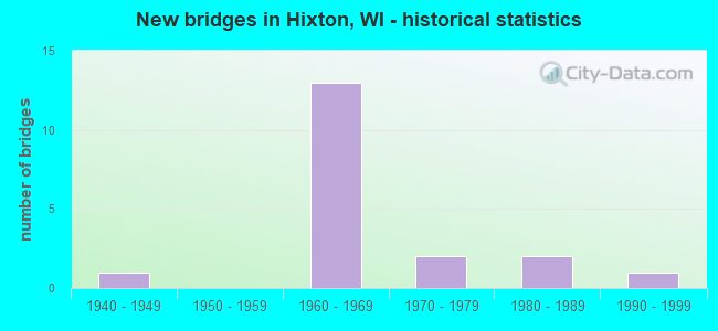
- New bridges - historical statistics
- 11940-1949
- 131960-1969
- 21970-1979
- 21980-1989
- 11990-1999

- Reconstructed bridges - Historical Statistics
- 31980-1989
- 11990-1999


- Bridge Condition - Deck
- 54.5%Good
- 27.3%Satisfactory
- 18.2%Fair

- Bridge Condition - Superstructure
- 9.1%Very good
- 36.4%Good
- 36.4%Satisfactory
- 18.2%Fair

- Bridge Condition - Substructure
- 18.2%Very good
- 27.3%Good
- 54.5%Satisfactory

- Bridge Condition - Channel
- 72.7%Very good
- 18.2%Satisfactory
- 9.1%Fair

- Bridge Condition - Culverts
- 75.0%Satisfactory
- 25.0%Poor
Find on map >> Show street view
Structure Number: B27002, Location: 2.3M N JCT STH 95 (Lat: 44.410911, Lng: -91.039950), Route carried "on" structure: County highway , Year Built: 1966, Year Reconstructed: 1986, Status: Open, Structure Length: 7.09m (23.26ft), Average Daily Traffic: 270 (year 2019), Average Future Daily Traffic: 500 (year 2040), Design Load: H 20, Features Intersected: IH 94, Facility Carried by Structure: CTH FF
Minimum Vertical Clearance: 30+ m (98+ ft), Kilometerpoint: 0.000, Lanes on structure: 2, Lanes under structure: 4, Owner: State Highway Agency, Approaching Roadway Width: 9.8m (32.2ft), Skew: 3 degrees, Material/Design: Steel continuous, Design/Construction: Stringer/Multi-beam, Number Of Spans In Main Unit: 2, Length of Maximum Span: 34.7m (113.8ft), Curb-To-Curb Width: 9.1m (29.9ft), Out-to-Out Width: 10.7m (35.1ft)
Condition: Deck: Good, Superstructure: Satisfactory, Substructure: Satisfactory, Operating Rating: 47.4 metric tons, Method Used To Determine Operating Rating: Load Factor (LF), Inventory Rating: 27.5 metric tons, Method Used To Determine Inventory Rating: Load Factor (LF), Structural Evaluation: Equal to present minimum criteria, Deck Geometry: Equal to present minimum criteria, Underclear: Somewhat better than minimum adequacy, Approach Roadway Alignment: Equal to present minimum criteria, Designated Inspection Frequency: Every 24 months, Inspection Date: September 2021, Deck Structure Type: Concrete Cast-file-Place, Wearing Surface/Protective System: Wearing Surface: Monolithic Concrete, Deck Protection: Epoxy Coated Reinforcing
Find on map >> Show street view
Structure Number: B270021, Location: 6.8M E JCT STH 121 TO E (Lat: 44.388706, Lng: -91.006511), Route carried "on" structure: Interstate 94, Year Built: 1966, Year Reconstructed: 2001, Status: Open, Structure Length: 4.18m (13.71ft), Average Daily Traffic: 12,700 (year 2019), Truck Traffic: 16%, Average Future Daily Traffic: 19,200 (year 2040), Design Load: HS 20, Features Intersected: TREMPEALEAU RIVER
Minimum Vertical Clearance: 30+ m (98+ ft), Kilometerpoint: 0.000, Lanes on structure: 2, Base Highway Network: Yes, Owner: State Highway Agency, Approaching Roadway Width: 12.2m (40.0ft), Skew: 2 degrees, Material/Design: Concrete continuous, Design/Construction: Slab, Number Of Spans In Main Unit: 3, Length of Maximum Span: 16.8m (55.1ft), Curb-To-Curb Width: 13.4m (44.0ft), Out-to-Out Width: 14.0m (45.9ft)
Condition: Deck: Good, Superstructure: Good, Substructure: Good, Channel: Very good, Operating Rating: 65.0 metric tons, Method Used To Determine Operating Rating: Load Factor (LF), Inventory Rating: 38.9 metric tons, Method Used To Determine Inventory Rating: Load Factor (LF), Structural Evaluation: Better than present minimum criteria, Deck Geometry: Superior to present desirable criteria, Waterway Adequacy: Equal to present desirable criteria, Approach Roadway Alignment: Equal to present desirable criteria, Designated Inspection Frequency: Every 24 months, Inspection Date: September 2021, Deck Structure Type: Concrete Cast-file-Place, Wearing Surface/Protective System: Wearing Surface: Low Slump Concrete
Find on map >> Show street view
Structure Number: B270022, Location: 0.2M W JCT STH 95 TO E (Lat: 44.388667, Lng: -91.005497), Route carried "on" structure: Interstate 94, Year Built: 1966, Year Reconstructed: 1986, Status: Open, Structure Length: 4.18m (13.71ft), Average Daily Traffic: 12,700 (year 2019), Truck Traffic: 16%, Average Future Daily Traffic: 16,600 (year 2040), Design Load: HS 20, Features Intersected: TREMPEALEAU RIVER
Minimum Vertical Clearance: 30+ m (98+ ft), Kilometerpoint: 0.000, Lanes on structure: 3, Base Highway Network: Yes, Owner: State Highway Agency, Approaching Roadway Width: 12.2m (40.0ft), Skew: 2 degrees, Material/Design: Concrete continuous, Design/Construction: Slab, Number Of Spans In Main Unit: 3, Length of Maximum Span: 16.8m (55.1ft), Curb-To-Curb Width: 15.7m (51.5ft), Out-to-Out Width: 16.6m (54.5ft)
Condition: Deck: Good, Superstructure: Good, Substructure: Good, Channel: Very good, Operating Rating: 73.0 metric tons, Method Used To Determine Operating Rating: Load Factor (LF), Inventory Rating: 43.7 metric tons, Method Used To Determine Inventory Rating: Load Factor (LF), Structural Evaluation: Better than present minimum criteria, Deck Geometry: Somewhat better than minimum adequacy, Waterway Adequacy: Equal to present desirable criteria, Approach Roadway Alignment: Equal to present desirable criteria, Designated Inspection Frequency: Every 24 months, Inspection Date: September 2021, Deck Structure Type: Concrete Cast-file-Place, Wearing Surface/Protective System: Wearing Surface: Epoxy Overlay, Deck Protection: Epoxy Coated Reinforcing
Find on map >> Show street view
Structure Number: B270023, Location: 0.3M E JCT CTH A (Lat: 44.385669, Lng: -91.004828), Route carried "on" structure: State highway 95, Year Built: 1966, Status: Open, Structure Length: 1.42m (4.66ft), Average Daily Traffic: 5,000 (year 2019), Truck Traffic: 6%, Average Future Daily Traffic: 5,180 (year 2040), Design Load: HS 20, Features Intersected: TANK CREEK
Minimum Vertical Clearance: 30+ m (98+ ft), Kilometerpoint: 0.000, Lanes on structure: 3, Owner: State Highway Agency, Approaching Roadway Width: 16.8m (55.1ft), Skew: 21 degrees, Material/Design: Concrete continuous, Design/Construction: Culvert, Number Of Spans In Main Unit: 3, Length of Maximum Span: 4.3m (14.1ft)
Condition: Channel: Satisfactory, Culverts: Satisfactory, Operating Rating: 53.9 metric tons, Method Used To Determine Operating Rating: Field evaluation and documented engineering judgment, Inventory Rating: 32.4 metric tons, Method Used To Determine Inventory Rating: Field evaluation and documented engineering judgment, Structural Evaluation: Equal to present minimum criteria, Waterway Adequacy: Better than present minimum criteria, Approach Roadway Alignment: Equal to present desirable criteria, Designated Inspection Frequency: Every 24 months, Inspection Date: September 2021, Deck Structure Type: Concrete Cast-file-Place, Wearing Surface/Protective System: Wearing Surface: Bituminous
Find on map >> Show street view
Structure Number: B270024, Location: 7.0M E JCT STH 121 TO E (Lat: 44.386922, Lng: -91.002914), Route carried "on" structure: Interstate 94, Year Built: 1966, Status: Open, Structure Length: 7.73m (25.36ft), Average Daily Traffic: 12,700 (year 2019), Truck Traffic: 16%, Average Future Daily Traffic: 23,254 (year 2040), Design Load: HS 20+Mod, Features Intersected: STH 95
Minimum Vertical Clearance: 30+ m (98+ ft), Kilometerpoint: 0.000, Lanes on structure: 3, Lanes under structure: 2, Base Highway Network: Yes, Owner: State Highway Agency, Approaching Roadway Width: 12.2m (40.0ft), Skew: 2 degrees, Material/Design: Steel continuous, Design/Construction: Stringer/Multi-beam, Number Of Spans In Main Unit: 4, Length of Maximum Span: 23.0m (75.5ft), Curb-To-Curb Width: 17.4m (57.1ft), Out-to-Out Width: 18.3m (60.0ft)
Condition: Deck: Satisfactory, Superstructure: Satisfactory, Substructure: Satisfactory, Operating Rating: 52.3 metric tons, Method Used To Determine Operating Rating: Load Factor (LF), Inventory Rating: 30.8 metric tons, Method Used To Determine Inventory Rating: Load Factor (LF), Structural Evaluation: Equal to present minimum criteria, Deck Geometry: Better than present minimum criteria, Underclear: Somewhat better than minimum adequacy, Approach Roadway Alignment: Equal to present desirable criteria, Designated Inspection Frequency: Every 24 months, Inspection Date: September 2021, Deck Structure Type: Concrete Cast-file-Place, Wearing Surface/Protective System: Wearing Surface: Low Slump Concrete, Deck Protection: Epoxy Coated Reinforcing
Find on map >> Show street view
Structure Number: B270025, Location: 9.9M W JCT USH 12 TO E (Lat: 44.386761, Lng: -91.001622), Route carried "on" structure: Interstate 94, Year Built: 1966, Year Reconstructed: 1986, Status: Open, Structure Length: 7.69m (25.23ft), Average Daily Traffic: 12,700 (year 2019), Truck Traffic: 16%, Average Future Daily Traffic: 6,705 (year 2040), Design Load: HS 20+Mod, Features Intersected: STH 95
Minimum Vertical Clearance: 30+ m (98+ ft), Kilometerpoint: 0.000, Lanes on structure: 2, Lanes under structure: 2, Base Highway Network: Yes, Owner: State Highway Agency, Approaching Roadway Width: 12.2m (40.0ft), Skew: 2 degrees, Material/Design: Steel continuous, Design/Construction: Stringer/Multi-beam, Number Of Spans In Main Unit: 4, Length of Maximum Span: 23.0m (75.5ft), Curb-To-Curb Width: 13.5m (44.3ft), Out-to-Out Width: 14.4m (47.2ft)
Condition: Deck: Satisfactory, Superstructure: Satisfactory, Substructure: Satisfactory, Operating Rating: 52.3 metric tons, Method Used To Determine Operating Rating: Load Factor (LF), Inventory Rating: 30.8 metric tons, Method Used To Determine Inventory Rating: Load Factor (LF), Structural Evaluation: Equal to present minimum criteria, Deck Geometry: Superior to present desirable criteria, Underclear: Somewhat better than minimum adequacy, Approach Roadway Alignment: Equal to present desirable criteria, Designated Inspection Frequency: Every 24 months, Inspection Date: September 2021, Deck Structure Type: Concrete Cast-file-Place, Wearing Surface/Protective System: Wearing Surface: Monolithic Concrete, Deck Protection: Epoxy Coated Reinforcing
Find on map >> Show street view
Structure Number: B270026, Location: 0.2M N JCT CTH A (Lat: 44.361628, Lng: -90.963908), Route carried "on" structure: City street , Year Built: 1966, Status: Open, Structure Length: 7.23m (23.72ft), Average Daily Traffic: 300 (year 2019), Average Future Daily Traffic: 110 (year 2040), Design Load: H 15, Features Intersected: IH 94, Facility Carried by Structure: LRD S POLE GROVE R
Minimum Vertical Clearance: 30+ m (98+ ft), Kilometerpoint: 0.000, Lanes on structure: 2, Lanes under structure: 4, Owner: State Highway Agency, Approaching Roadway Width: 12.2m (40.0ft), Skew: 3 degrees, Material/Design: Steel continuous, Design/Construction: Stringer/Multi-beam, Number Of Spans In Main Unit: 2, Length of Maximum Span: 35.4m (116.1ft), Curb-To-Curb Width: 8.2m (26.9ft), Out-to-Out Width: 9.3m (30.5ft)
Condition: Deck: Fair, Superstructure: Fair, Substructure: Satisfactory, Operating Rating: 29.4 metric tons, Method Used To Determine Operating Rating: Load Factor (LF), Inventory Rating: 17.8 metric tons, Method Used To Determine Inventory Rating: Load Factor (LF), Structural Evaluation: Somewhat better than minimum adequacy, Deck Geometry: Somewhat better than minimum adequacy, Underclear: Equal to present minimum criteria, Approach Roadway Alignment: Equal to present desirable criteria, Designated Inspection Frequency: Every 24 months, Inspection Date: September 2021, Deck Structure Type: Concrete Cast-file-Place, Wearing Surface/Protective System: Wearing Surface: Monolithic Concrete
Find on map >> Show street view
Structure Number: B270058, Location: 0.3M S JCT STH 95 (Lat: 44.377681, Lng: -91.030708), Route carried "on" structure: City street , Year Built: 1979, Status: Open, Structure Length: 2.98m (9.78ft), Average Daily Traffic: 130 (year 2019), Average Future Daily Traffic: 143 (year 2039), Design Load: H 20, Features Intersected: TREMPEALEAU RIVER, Facility Carried by Structure: LRD SECHLERVILLE R
Minimum Vertical Clearance: 30+ m (98+ ft), Kilometerpoint: 0.000, Lanes on structure: 2, Owner: City or Municipal Highway Agency, Approaching Roadway Width: 8.5m (27.9ft), Material/Design: Concrete, Design/Construction: Slab, Number Of Spans In Main Unit: 2, Length of Maximum Span: 14.6m (47.9ft), Curb-To-Curb Width: 9.1m (29.9ft), Out-to-Out Width: 9.8m (32.2ft)
Condition: Deck: Fair, Superstructure: Fair, Substructure: Satisfactory, Channel: Very good, Operating Rating: 47.4 metric tons, Method Used To Determine Operating Rating: Load Factor (LF), Inventory Rating: 27.5 metric tons, Method Used To Determine Inventory Rating: Load Factor (LF), Structural Evaluation: Somewhat better than minimum adequacy, Deck Geometry: Equal to present minimum criteria, Waterway Adequacy: Equal to present desirable criteria, Approach Roadway Alignment: Equal to present desirable criteria, Designated Inspection Frequency: Every 24 months, Inspection Date: September 2020, Deck Structure Type: Concrete Cast-file-Place, Wearing Surface/Protective System: Wearing Surface: Low Slump Concrete
Find on map >> Show street view
Structure Number: B270062, Location: 0.2M N JCT CTH A (Lat: 44.360694, Lng: -90.963933), Route carried "on" structure: City street , Year Built: 1966, Status: Open, Structure Length: 0.89m (2.92ft), Average Daily Traffic: 176 (year 2019), Average Future Daily Traffic: 193 (year 2039), Design Load: H 15, Features Intersected: TANK CREEK, Facility Carried by Structure: LRD S POLE GROVE R
Minimum Vertical Clearance: 30+ m (98+ ft), Kilometerpoint: 0.000, Lanes on structure: 2, Owner: Town or Township Highway Agency, Approaching Roadway Width: 7.3m (24.0ft), Skew: 3 degrees, Material/Design: Concrete continuous, Design/Construction: Culvert, Number Of Spans In Main Unit: 2, Length of Maximum Span: 3.7m (12.1ft)
Condition: Channel: Fair, Culverts: Satisfactory, Operating Rating: 53.9 metric tons, Method Used To Determine Operating Rating: Field evaluation and documented engineering judgment, Inventory Rating: 24.3 metric tons, Method Used To Determine Inventory Rating: Field evaluation and documented engineering judgment, Structural Evaluation: Equal to present minimum criteria, Waterway Adequacy: Superior to present desirable criteria, Approach Roadway Alignment: Equal to present minimum criteria, Designated Inspection Frequency: Every 24 months, Inspection Date: November 2020, Deck Structure Type: Concrete Cast-file-Place, Wearing Surface/Protective System: Wearing Surface: Bituminous
Find on map >> Show street view
Structure Number: B270089, Location: 2.3M N JCT STH 95 (Lat: 44.420367, Lng: -90.992728), Route carried "on" structure: City street , Year Built: 1989, Status: Open, Structure Length: 1.40m (4.59ft), Average Daily Traffic: 199 (year 2019), Average Future Daily Traffic: 218 (year 2039), Design Load: HS 20, Features Intersected: N BR TREMPEALEAU RIVER, Facility Carried by Structure: LRD N BRANCH RD
Minimum Vertical Clearance: 30+ m (98+ ft), Kilometerpoint: 0.000, Lanes on structure: 2, Owner: Town or Township Highway Agency, Approaching Roadway Width: 7.9m (25.9ft), Skew: 2 degrees, Material/Design: Concrete, Design/Construction: Slab, Number Of Spans In Main Unit: 1, Length of Maximum Span: 13.4m (44.0ft), Curb-To-Curb Width: 7.3m (24.0ft), Out-to-Out Width: 7.9m (25.9ft)
Condition: Deck: Good, Superstructure: Good, Substructure: Very good, Channel: Very good, Operating Rating: 58.8 metric tons, Method Used To Determine Operating Rating: Load Factor (LF), Inventory Rating: 34.0 metric tons, Method Used To Determine Inventory Rating: Load Factor (LF), Structural Evaluation: Better than present minimum criteria, Deck Geometry: Somewhat better than minimum adequacy, Waterway Adequacy: Superior to present desirable criteria, Approach Roadway Alignment: Equal to present desirable criteria, Designated Inspection Frequency: Every 48 months, Inspection Date: November 2020, Deck Structure Type: Concrete Cast-file-Place, Wearing Surface/Protective System: Wearing Surface: Monolithic Concrete, Deck Protection: Epoxy Coated Reinforcing
Find on map >> Show street view
Structure Number: B270091, Location: 0.9M E JCT CTH FF TO S (Lat: 44.403467, Lng: -90.973403), Route carried "on" structure: State highway 95, Year Built: 1989, Status: Open, Structure Length: 1.82m (5.97ft), Average Daily Traffic: 1,700 (year 2019), Truck Traffic: 11%, Average Future Daily Traffic: 1,600 (year 2038), Design Load: HS 20, Features Intersected: S BR TREMPEALEAU RIVER
Minimum Vertical Clearance: 30+ m (98+ ft), Kilometerpoint: 0.000, Lanes on structure: 2, Owner: State Highway Agency, Approaching Roadway Width: 11.0m (36.1ft), Material/Design: Prestressed concrete, Design/Construction: Stringer/Multi-beam, Number Of Spans In Main Unit: 1, Length of Maximum Span: 17.7m (58.1ft), Curb-To-Curb Width: 11.0m (36.1ft), Out-to-Out Width: 11.6m (38.1ft)
Condition: Deck: Good, Superstructure: Good, Substructure: Good, Channel: Very good, Operating Rating: 57.0 metric tons, Method Used To Determine Operating Rating: Load Factor (LF), Inventory Rating: 37.3 metric tons, Method Used To Determine Inventory Rating: Load Factor (LF), Structural Evaluation: Better than present minimum criteria, Deck Geometry: Equal to present minimum criteria, Waterway Adequacy: Equal to present desirable criteria, Approach Roadway Alignment: Equal to present desirable criteria, Designated Inspection Frequency: Every 48 months, Inspection Date: September 2019, Deck Structure Type: Concrete Cast-file-Place, Wearing Surface/Protective System: Wearing Surface: Monolithic Concrete, Deck Protection: Epoxy Coated Reinforcing
Find on map >> Show street view
Structure Number: B270114, Location: 3.6M E JCT CTH G (Lat: 44.380883, Lng: -91.029325), Route carried "on" structure: State highway 95, Year Built: 1996, Status: Open, Structure Length: 1.70m (5.58ft), Average Daily Traffic: 3,800 (year 2019), Average Future Daily Traffic: 3,500 (year 2038), Design Load: HS 20, Features Intersected: STONY CREEK
Minimum Vertical Clearance: 30+ m (98+ ft), Kilometerpoint: 0.000, Lanes on structure: 2, Owner: State Highway Agency, Approaching Roadway Width: 12.2m (40.0ft), Material/Design: Prestressed concrete, Design/Construction: Stringer/Multi-beam, Number Of Spans In Main Unit: 1, Length of Maximum Span: 15.8m (51.8ft), Curb-To-Curb Width: 12.2m (40.0ft), Out-to-Out Width: 12.7m (41.7ft)
Condition: Deck: Good, Superstructure: Very good, Substructure: Very good, Channel: Very good, Operating Rating: 63.7 metric tons, Method Used To Determine Operating Rating: Load Factor (LF), Inventory Rating: 37.3 metric tons, Method Used To Determine Inventory Rating: Load Factor (LF), Structural Evaluation: Equal to present desirable criteria, Deck Geometry: Equal to present minimum criteria, Waterway Adequacy: Equal to present desirable criteria, Approach Roadway Alignment: Equal to present desirable criteria, Designated Inspection Frequency: Every 48 months, Inspection Date: September 2019, Deck Structure Type: Concrete Cast-file-Place, Wearing Surface/Protective System: Wearing Surface: Monolithic Concrete, Deck Protection: Epoxy Coated Reinforcing
Find on map >> Show street view
Structure Number: B270167, Location: 3.0 MILES E. OF STH 95 (Lat: 44.358056, Lng: -90.957222), Route carried "on" structure: Interstate 94, Year Built: 1966, Status: Open, Structure Length: 0.62m (2.03ft), Average Daily Traffic: 24,900 (year 2019), Average Future Daily Traffic: 24,900 (year 2040), Design Load: HS 20, Features Intersected: TANK CREEK
Minimum Vertical Clearance: 30+ m (98+ ft), Kilometerpoint: 0.000, Lanes on structure: 4, Base Highway Network: Yes, Owner: State Highway Agency, Approaching Roadway Width: 22.6m (74.1ft), Material/Design: Concrete continuous, Design/Construction: Culvert, Number Of Spans In Main Unit: 2, Length of Maximum Span: 2.7m (8.9ft)
Condition: Channel: Very good, Culverts: Satisfactory, Operating Rating: 53.9 metric tons, Method Used To Determine Operating Rating: Field evaluation and documented engineering judgment, Inventory Rating: 32.4 metric tons, Method Used To Determine Inventory Rating: Field evaluation and documented engineering judgment, Structural Evaluation: Equal to present minimum criteria, Waterway Adequacy: Equal to present desirable criteria, Approach Roadway Alignment: Equal to present desirable criteria, Designated Inspection Frequency: Every 24 months, Inspection Date: September 2021
Find on map >> Show street view
Structure Number: P270928, Location: 0.3M N JCT STH 95 (Lat: 44.397178, Lng: -90.991181), Route carried "on" structure: City street , Year Built: 1974, Status: Open, Structure Length: 1.98m (6.50ft), Average Daily Traffic: 205 (year 2019), Average Future Daily Traffic: 225 (year 2039), Design Load: HS 20, Features Intersected: S BR TREMPEALEAU RIVER, Facility Carried by Structure: LRD N BRANCH RD
Minimum Vertical Clearance: 30+ m (98+ ft), Kilometerpoint: 0.000, Lanes on structure: 2, Owner: Town or Township Highway Agency, Approaching Roadway Width: 8.5m (27.9ft), Material/Design: Concrete continuous, Design/Construction: Slab, Number Of Spans In Main Unit: 2, Length of Maximum Span: 9.1m (29.9ft), Curb-To-Curb Width: 9.1m (29.9ft), Out-to-Out Width: 10.3m (33.8ft)
Condition: Deck: Satisfactory, Superstructure: Satisfactory, Substructure: Satisfactory, Channel: Satisfactory, Operating Rating: 44.1 metric tons, Method Used To Determine Operating Rating: Load Factor (LF), Inventory Rating: 25.9 metric tons, Method Used To Determine Inventory Rating: Load Factor (LF), Structural Evaluation: Equal to present minimum criteria, Deck Geometry: Equal to present minimum criteria, Waterway Adequacy: Equal to present minimum criteria, Approach Roadway Alignment: Equal to present minimum criteria, Designated Inspection Frequency: Every 24 months, Inspection Date: November 2020, Deck Structure Type: Concrete Cast-file-Place, Wearing Surface/Protective System: Wearing Surface: Bituminous
Find on map >> Show street view
Structure Number: P270932, Location: 0.8M N JCT STH 95 (Lat: 44.403931, Lng: -90.996983), Route carried "on" structure: City street , Year Built: 1941, Status: Open, Structure Length: 0.70m (2.30ft), Average Daily Traffic: 10 (year 2019), Average Future Daily Traffic: 11 (year 2040), Design Load: H 15, Features Intersected: N BR TREMPEALEAU RIVER, Facility Carried by Structure: LRD CAIN ROAD (DEA
Minimum Vertical Clearance: 30+ m (98+ ft), Kilometerpoint: 0.000, Lanes on structure: 2, Owner: Town or Township Highway Agency, Approaching Roadway Width: 6.1m (20.0ft), Material/Design: Concrete continuous, Design/Construction: Culvert, Number Of Spans In Main Unit: 2, Length of Maximum Span: 3.0m (9.8ft)
Condition: Channel: Very good, Culverts: Poor, Operating Rating: 33.0 metric tons, Method Used To Determine Operating Rating: Field evaluation and documented engineering judgment, Inventory Rating: 19.4 metric tons, Method Used To Determine Inventory Rating: Field evaluation and documented engineering judgment, Structural Evaluation: Meets minimum limits, Waterway Adequacy: Superior to present desirable criteria, Approach Roadway Alignment: Meets minimum limits, Length Of Structure Improvement: 1.16m (3.81ft), Designated Inspection Frequency: Every 12 months, Inspection Date: November 2021, Bridge Improvement Cost: $88,000, Roadway Improvement Cost: $8,000, Total Project Cost: $133,000 ( Estimate for 2021), Deck Structure Type: Concrete Cast-file-Place, Wearing Surface/Protective System: Wearing Surface: Monolithic Concrete
Find on map >> Show street view
Structure Number: B27002, Location: 4.5M E JCT STH 121 TO E (Lat: 44.410911, Lng: -91.039950), Route carried "under" structure: Interstate 94, Year Built: 1966, Structure Length: 0. m, Average Daily Traffic: 25,400 (year 2019), Truck Traffic: 16%, Features Intersected: IH 94, Facility Carried by Structure: CTH FF
Minimum Vertical Clearance: 4.88m (16.01ft), Kilometerpoint: 0.000, Lanes on structure: 2, Lanes under structure: 4, Material/Design: Steel continuous, Design/Construction: Stringer/Multi-beam, Length of Maximum Span: 34.7m (113.8ft)
Find on map >> Show street view
Structure Number: B270024, Location: 0.5M E JCT CTH A (Lat: 44.386922, Lng: -91.002914), Route carried "under" structure: State highway 95, Year Built: 1966, Structure Length: 0. m, Average Daily Traffic: 5,000 (year 2019), Truck Traffic: 6%, Features Intersected: STH 95, Facility Carried by Structure: IH 94 EB
Minimum Vertical Clearance: 6.23m (20.44ft), Kilometerpoint: 0.000, Lanes on structure: 3, Lanes under structure: 2, Material/Design: Steel continuous, Design/Construction: Stringer/Multi-beam, Length of Maximum Span: 23.0m (75.5ft)
Find on map >> Show street view
Structure Number: B270025, Location: 0.5M E JCT CTH A (Lat: 44.386761, Lng: -91.001622), Route carried "under" structure: State highway 95, Year Built: 1966, Structure Length: 0. m, Average Daily Traffic: 5,000 (year 2019), Truck Traffic: 6%, Features Intersected: STH 95, Facility Carried by Structure: IH 94 WB
Minimum Vertical Clearance: 6.27m (20.57ft), Kilometerpoint: 0.000, Lanes on structure: 2, Lanes under structure: 2, Material/Design: Steel continuous, Design/Construction: Stringer/Multi-beam, Length of Maximum Span: 23.0m (75.5ft)
Find on map >> Show street view
Structure Number: B270026, Location: 2.7M E JCT STH 95 TO E (Lat: 44.361628, Lng: -90.963908), Route carried "under" structure: Interstate 94, Year Built: 1966, Structure Length: 0. m, Average Daily Traffic: 24,900 (year 2019), Truck Traffic: 16%, Features Intersected: IH 94, Facility Carried by Structure: LRD S POLE GROVE R
Minimum Vertical Clearance: 5.04m (16.54ft), Kilometerpoint: 0.000, Lanes on structure: 2, Lanes under structure: 4, Material/Design: Steel continuous, Design/Construction: Stringer/Multi-beam, Length of Maximum Span: 35.4m (116.1ft)