Bridge Statistics for Hodgkins, Illinois (IL)
Condition, Traffic, Stress, Structural Evaluation, Project Costs
- National Bridge Inventory (NBI) Statistics
- 16Number of bridges
- 574ft / 175mTotal length
- 772,700Total average daily traffic
- 92,786Total average daily truck traffic
- National Bridge Inventory (NBI) Registered Bridges for Hodgkins
- No street view available for this location
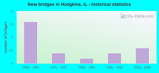
- New bridges - historical statistics
- 81960-1969
- 21970-1979
- 11980-1989
- 21990-1999
- 32000-2009

- Reconstructed bridges - Historical Statistics
- 41990-1999
- 32000-2009


- Bridge Condition - Deck
- 80.0%Good
- 10.0%Satisfactory
- 10.0%Poor

- Bridge Condition - Superstructure
- 10.0%Very good
- 20.0%Good
- 70.0%Fair

- Bridge Condition - Substructure
- 10.0%Very good
- 50.0%Good
- 30.0%Satisfactory
- 10.0%Poor
Find on map >> Show street view
Structure Number: 160004, Location: 0.3 M E US 45 (Lat: 41.762419, Lng: -87.862014), Route carried "on" structure: Interstate 55, Year Built: 1964, Year Reconstructed: 1999, Status: Open, Structure Length: 13.03m (42.75ft), Average Daily Traffic: 59,150 (year 2021), Truck Traffic: 12%, Average Future Daily Traffic: 83,945 (year 2032), Features Intersected: RR - BNSF
Minimum Vertical Clearance: 30+ m (98+ ft), Kilometerpoint: 449.429, Lanes on structure: 3, Base Highway Network: Yes, Owner: State Highway Agency, Approaching Roadway Width: 23.3m (76.4ft), Skew: 5 degrees, Material/Design: Steel continuous, Design/Construction: Stringer/Multi-beam, Number Of Spans In Main Unit: 4, Length of Maximum Span: 35.7m (117.1ft), Curb-To-Curb Width: 23.3m (76.4ft), Out-to-Out Width: 24.3m (79.7ft)
Condition: Deck: Good, Superstructure: Fair, Substructure: Good, Operating Rating: 62.2 metric tons, Method Used To Determine Operating Rating: Load Factor (LF) rating reported by rating factor (RF) method using MS18 loading, Inventory Rating: 37.6 metric tons, Method Used To Determine Inventory Rating: Load Factor (LF) rating reported by rating factor (RF) method using MS18 loading, Structural Evaluation: Somewhat better than minimum adequacy, Deck Geometry: Superior to present desirable criteria, Underclear: Better than present minimum criteria, Approach Roadway Alignment: Equal to present desirable criteria, Designated Inspection Frequency: Every 24 months, Inspection Date: Febuary 2020, Deck Structure Type: Concrete Cast-file-Place, Wearing Surface/Protective System: Deck Protection: Epoxy Coated Reinforcing
Find on map >> Show street view
Structure Number: 160005, Location: 0.3 M E US 45 (Lat: 41.762439, Lng: -87.861900), Route carried "on" structure: Interstate 55, Year Built: 1964, Year Reconstructed: 2000, Status: Open, Structure Length: 13.03m (42.75ft), Average Daily Traffic: 59,150 (year 2021), Truck Traffic: 12%, Average Future Daily Traffic: 83,945 (year 2032), Features Intersected: RR - BNSF
Minimum Vertical Clearance: 30+ m (98+ ft), Kilometerpoint: 449.445, Lanes on structure: 4, Base Highway Network: Yes, Owner: State Highway Agency, Approaching Roadway Width: 29.5m (96.8ft), Skew: 5 degrees, Material/Design: Steel continuous, Design/Construction: Stringer/Multi-beam, Number Of Spans In Main Unit: 4, Length of Maximum Span: 35.7m (117.1ft), Curb-To-Curb Width: 29.5m (96.8ft), Out-to-Out Width: 30.5m (100.1ft)
Condition: Deck: Good, Superstructure: Fair, Substructure: Good, Operating Rating: 65.4 metric tons, Method Used To Determine Operating Rating: Load Factor (LF) rating reported by rating factor (RF) method using MS18 loading, Inventory Rating: 39.2 metric tons, Method Used To Determine Inventory Rating: Load Factor (LF) rating reported by rating factor (RF) method using MS18 loading, Structural Evaluation: Somewhat better than minimum adequacy, Deck Geometry: Superior to present desirable criteria, Underclear: Better than present minimum criteria, Approach Roadway Alignment: Equal to present desirable criteria, Designated Inspection Frequency: Every 24 months, Inspection Date: Febuary 2020, Deck Structure Type: Concrete Cast-file-Place, Wearing Surface/Protective System: Deck Protection: Epoxy Coated Reinforcing
Find on map >> Show street view
Structure Number: 160006, Location: 0.4 M E US 45 (Lat: 41.762692, Lng: -87.860100), Route carried "on" structure: Interstate 55, Year Built: 1963, Year Reconstructed: 1999, Status: Open, Structure Length: 7.86m (25.79ft), Average Daily Traffic: 59,150 (year 2021), Truck Traffic: 12%, Average Future Daily Traffic: 83,945 (year 2032), Features Intersected: SANTA FE DR
Minimum Vertical Clearance: 30+ m (98+ ft), Kilometerpoint: 449.703, Lanes on structure: 3, Lanes under structure: 2, Base Highway Network: Yes, Owner: State Highway Agency, Approaching Roadway Width: 19.9m (65.3ft), Skew: 5 degrees, Material/Design: Steel continuous, Design/Construction: Stringer/Multi-beam, Number Of Spans In Main Unit: 3, Length of Maximum Span: 29.6m (97.1ft), Curb-To-Curb Width: 19.9m (65.3ft), Out-to-Out Width: 20.8m (68.2ft)
Condition: Deck: Good, Superstructure: Fair, Substructure: Satisfactory, Operating Rating: 59.6 metric tons, Method Used To Determine Operating Rating: Load Factor (LF) rating reported by rating factor (RF) method using MS18 loading, Inventory Rating: 35.6 metric tons, Method Used To Determine Inventory Rating: Load Factor (LF) rating reported by rating factor (RF) method using MS18 loading, Structural Evaluation: Somewhat better than minimum adequacy, Deck Geometry: Superior to present desirable criteria, Underclear: Better than present minimum criteria, Approach Roadway Alignment: Equal to present desirable criteria, Designated Inspection Frequency: Every 24 months, Inspection Date: July 2020, Deck Structure Type: Concrete Cast-file-Place, Wearing Surface/Protective System: Deck Protection: Epoxy Coated Reinforcing
Find on map >> Show street view
Structure Number: 160007, Location: 0.4 M E US 45 (Lat: 41.762706, Lng: -87.859986), Route carried "on" structure: Interstate 55, Year Built: 1963, Year Reconstructed: 2000, Status: Open, Structure Length: 7.86m (25.79ft), Average Daily Traffic: 59,150 (year 2021), Truck Traffic: 12%, Average Future Daily Traffic: 83,945 (year 2032), Features Intersected: SANTA FE DR
Minimum Vertical Clearance: 30+ m (98+ ft), Kilometerpoint: 449.719, Lanes on structure: 3, Lanes under structure: 2, Base Highway Network: Yes, Owner: State Highway Agency, Approaching Roadway Width: 22.6m (74.1ft), Skew: 5 degrees, Material/Design: Steel continuous, Design/Construction: Stringer/Multi-beam, Number Of Spans In Main Unit: 3, Length of Maximum Span: 29.6m (97.1ft), Curb-To-Curb Width: 23.0m (75.5ft), Out-to-Out Width: 24.0m (78.7ft)
Condition: Deck: Good, Superstructure: Fair, Substructure: Good, Operating Rating: 59.6 metric tons, Method Used To Determine Operating Rating: Load Factor (LF) rating reported by rating factor (RF) method using MS18 loading, Inventory Rating: 35.6 metric tons, Method Used To Determine Inventory Rating: Load Factor (LF) rating reported by rating factor (RF) method using MS18 loading, Structural Evaluation: Somewhat better than minimum adequacy, Deck Geometry: Superior to present desirable criteria, Underclear: Better than present minimum criteria, Approach Roadway Alignment: Equal to present desirable criteria, Designated Inspection Frequency: Every 24 months, Inspection Date: July 2020, Deck Structure Type: Concrete Cast-file-Place, Wearing Surface/Protective System: Deck Protection: Epoxy Coated Reinforcing
Find on map >> Show street view
Structure Number: 160008, Location: 0.6 M E US 45 (Lat: 41.762917, Lng: -87.858425), Route carried "on" structure: Interstate 55, Year Built: 1964, Year Reconstructed: 1999, Status: Open, Structure Length: 7.78m (25.52ft), Average Daily Traffic: 59,150 (year 2021), Truck Traffic: 12%, Average Future Daily Traffic: 83,945 (year 2032), Features Intersected: RR - BNSF
Minimum Vertical Clearance: 30+ m (98+ ft), Kilometerpoint: 449.912, Lanes on structure: 3, Base Highway Network: Yes, Owner: State Highway Agency, Approaching Roadway Width: 19.6m (64.3ft), Skew: 4 degrees, Material/Design: Steel continuous, Design/Construction: Stringer/Multi-beam, Number Of Spans In Main Unit: 3, Length of Maximum Span: 32.6m (107.0ft), Curb-To-Curb Width: 19.9m (65.3ft), Out-to-Out Width: 20.8m (68.2ft)
Condition: Deck: Good, Superstructure: Fair, Substructure: Satisfactory, Operating Rating: 79.1 metric tons, Method Used To Determine Operating Rating: Load Factor (LF) rating reported by rating factor (RF) method using MS18 loading, Inventory Rating: 47.3 metric tons, Method Used To Determine Inventory Rating: Load Factor (LF) rating reported by rating factor (RF) method using MS18 loading, Structural Evaluation: Somewhat better than minimum adequacy, Deck Geometry: Superior to present desirable criteria, Underclear: Superior to present desirable criteria, Approach Roadway Alignment: Equal to present desirable criteria, Designated Inspection Frequency: Every 24 months, Inspection Date: October 2021, Deck Structure Type: Concrete Cast-file-Place, Wearing Surface/Protective System: Deck Protection: Epoxy Coated Reinforcing
Find on map >> Show street view
Structure Number: 160009, Location: 0.6 M E US 45 (Lat: 41.762867, Lng: -87.858789), Route carried "on" structure: Interstate 55, Year Built: 1964, Year Reconstructed: 2000, Status: Open, Structure Length: 7.78m (25.52ft), Average Daily Traffic: 59,150 (year 2021), Truck Traffic: 12%, Average Future Daily Traffic: 83,945 (year 2032), Features Intersected: RR - BNSF
Minimum Vertical Clearance: 30+ m (98+ ft), Kilometerpoint: 449.880, Lanes on structure: 3, Base Highway Network: Yes, Owner: State Highway Agency, Approaching Roadway Width: 22.6m (74.1ft), Skew: 4 degrees, Material/Design: Steel continuous, Design/Construction: Stringer/Multi-beam, Number Of Spans In Main Unit: 3, Length of Maximum Span: 32.6m (107.0ft), Curb-To-Curb Width: 22.6m (74.1ft), Out-to-Out Width: 23.6m (77.4ft)
Condition: Deck: Good, Superstructure: Fair, Substructure: Satisfactory, Operating Rating: 69.0 metric tons, Method Used To Determine Operating Rating: Load Factor (LF) rating reported by rating factor (RF) method using MS18 loading, Inventory Rating: 41.5 metric tons, Method Used To Determine Inventory Rating: Load Factor (LF) rating reported by rating factor (RF) method using MS18 loading, Structural Evaluation: Somewhat better than minimum adequacy, Deck Geometry: Superior to present desirable criteria, Underclear: Superior to present desirable criteria, Approach Roadway Alignment: Equal to present desirable criteria, Designated Inspection Frequency: Every 24 months, Inspection Date: October 2021, Deck Structure Type: Concrete Cast-file-Place, Wearing Surface/Protective System: Deck Protection: Epoxy Coated Reinforcing
Find on map >> Show street view
Structure Number: 162467, Location: 0.5 M S I-55 (Lat: 41.758675, Lng: -87.867242), Route carried "on" structure: US 12, Year Built: 1975, Year Reconstructed: 2022, Status: Open, Structure Length: 83.67m (274.51ft), Average Daily Traffic: 64,200 (year 2021), Truck Traffic: 13%, Average Future Daily Traffic: 38,265 (year 2032), Design Load: HS 20, Features Intersected: SANTA FE DR ET AL
Minimum Vertical Clearance: 30+ m (98+ ft), Kilometerpoint: 101.788, Lanes on structure: 2, Lanes under structure: 2, Base Highway Network: Yes, Owner: State Highway Agency, Approaching Roadway Width: 11.6m (38.1ft), Material/Design: Steel continuous, Design/Construction: Stringer/Multi-beam, Number Of Spans In Main Unit: 30, Length of Maximum Span: 88.4m (290.0ft), Curb-To-Curb Width: 11.6m (38.1ft), Out-to-Out Width: 12.8m (42.0ft)
Condition: Deck: Poor, Superstructure: Fair, Substructure: Poor, Channel: Very good, Operating Rating: 32.4 metric tons, Method Used To Determine Operating Rating: Field evaluation and documented engineering judgment, Inventory Rating: 19.4 metric tons, Method Used To Determine Inventory Rating: Field evaluation and documented engineering judgment, Structural Evaluation: Meets minimum limits, Deck Geometry: Better than present minimum criteria, Underclear: High priority of corrective action, Waterway Adequacy: Equal to present desirable criteria, Approach Roadway Alignment: Better than present minimum criteria, Designated Inspection Frequency: Every 12 months, Critical Feature Inspection Frequency: Every 24 months, Underwater Inspection Frequency: Every 60 months, Inspection Date: August 2021, Critical Feature Inspection Date: August 2021, Underwater Inspection Date: May 2017, Deck Structure Type: Concrete Cast-file-Place, Wearing Surface/Protective System: Wearing Surface: Other
Find on map >> Show street view
Structure Number: 162665, Location: 5 M SW IL 43 (Lat: 41.761675, Lng: -87.867478), Route carried "on" structure: US 12, Year Built: 1995, Status: Open, Structure Length: 9.92m (32.55ft), Average Daily Traffic: 64,200 (year 2021), Truck Traffic: 13%, Average Future Daily Traffic: 76,529 (year 2032), Features Intersected: I- 55 STEVENSON
Minimum Vertical Clearance: 30+ m (98+ ft), Kilometerpoint: 101.418, Lanes on structure: 4, Lanes under structure: 6, Base Highway Network: Yes, Owner: State Highway Agency, Approaching Roadway Width: 28.8m (94.5ft), Skew: 30 degrees, Material/Design: Steel continuous, Design/Construction: Stringer/Multi-beam, Number Of Spans In Main Unit: 2, Number Of Approach Spans: 2, Length of Maximum Span: 42.0m (137.8ft), Curb-To-Curb Width: 29.1m (95.5ft), Out-to-Out Width: 31.1m (102.0ft)
Condition: Deck: Good, Superstructure: Good, Substructure: Good, Operating Rating: 61.2 metric tons, Method Used To Determine Operating Rating: Load Factor (LF) rating reported by rating factor (RF) method using MS18 loading, Inventory Rating: 36.6 metric tons, Method Used To Determine Inventory Rating: Load Factor (LF) rating reported by rating factor (RF) method using MS18 loading, Structural Evaluation: Better than present minimum criteria, Deck Geometry: Superior to present desirable criteria, Underclear: High priority of corrective action, Approach Roadway Alignment: Equal to present desirable criteria, Designated Inspection Frequency: Every 24 months, Inspection Date: September 2020, Deck Structure Type: Concrete Cast-file-Place, Wearing Surface/Protective System: Deck Protection: Epoxy Coated Reinforcing
Find on map >> Show street view
Structure Number: 162704, Location: 0.9 M E OF US 45 (Lat: 41.763578, Lng: -87.853689), Route carried "on" structure: Interstate 55, Year Built: 2000, Year Reconstructed: 2002, Status: Open, Structure Length: 21.42m (70.28ft), Average Daily Traffic: 138,600 (year 2021), Truck Traffic: 10%, Average Future Daily Traffic: 167,890 (year 2032), Features Intersected: DES PLAINES RIVER
Minimum Vertical Clearance: 30+ m (98+ ft), Kilometerpoint: 450.314, Lanes on structure: 6, Lanes under structure: 2, Base Highway Network: Yes, Owner: State Highway Agency, Approaching Roadway Width: 40.3m (132.2ft), Skew: 5 degrees, Material/Design: Steel continuous, Design/Construction: Stringer/Multi-beam, Number Of Spans In Main Unit: 5, Length of Maximum Span: 52.7m (172.9ft), Curb-To-Curb Width: 40.3m (132.2ft), Out-to-Out Width: 42.3m (138.8ft)
Condition: Deck: Satisfactory, Superstructure: Good, Substructure: Good, Channel: Very good, Operating Rating: 69.0 metric tons, Method Used To Determine Operating Rating: Load Factor (LF) rating reported by rating factor (RF) method using MS18 loading, Inventory Rating: 41.5 metric tons, Method Used To Determine Inventory Rating: Load Factor (LF) rating reported by rating factor (RF) method using MS18 loading, Structural Evaluation: Better than present minimum criteria, Deck Geometry: Superior to present desirable criteria, Underclear: High priority of corrective action, Waterway Adequacy: Equal to present desirable criteria, Approach Roadway Alignment: Equal to present desirable criteria, Designated Inspection Frequency: Every 24 months, Inspection Date: June 2021, Deck Structure Type: Concrete Cast-file-Place, Wearing Surface/Protective System: Deck Protection: Epoxy Coated Reinforcing
Find on map >> Show street view
Structure Number: 16719, Location: HODGKINS (Lat: 41.760306, Lng: -87.858856), Route carried "on" structure: Other road , Year Built: 2002, Status: Open, Structure Length: 2.61m (8.56ft), Average Daily Traffic: 2,700 (year 2018), Truck Traffic: 35%, Average Future Daily Traffic: 2,060 (year 2032), Design Load: HS 20, Features Intersected: BN SF RR, Facility Carried by Structure: Leon Cook/River 71
Minimum Vertical Clearance: 30+ m (98+ ft), Kilometerpoint: 2.897, Lanes on structure: 2, Owner: City or Municipal Highway Agency, Approaching Roadway Width: 9.1m (29.9ft), Material/Design: Steel, Design/Construction: Stringer/Multi-beam, Number Of Spans In Main Unit: 1, Length of Maximum Span: 24.4m (80.1ft), Curb or Sidewalk Widths: Left: 0.0m, Right: 1.8m (5.9ft), Curb-To-Curb Width: 9.1m (29.9ft), Out-to-Out Width: 11.8m (38.7ft)
Condition: Deck: Good, Superstructure: Very good, Substructure: Very good, Operating Rating: 42.1 metric tons, Method Used To Determine Operating Rating: Assigned ratings based on Load and Resistance Factor Design (LRFD) reported by rating factor (RF) using HL93 loadings, Inventory Rating: 32.4 metric tons, Method Used To Determine Inventory Rating: Assigned ratings based on Load and Resistance Factor Design (LRFD) reported by rating factor (RF) using HL93 loadings, Structural Evaluation: Equal to present desirable criteria, Deck Geometry: Meets minimum limits, Underclear: Equal to present desirable criteria, Approach Roadway Alignment: Superior to present desirable criteria, Designated Inspection Frequency: Every 48 months, Inspection Date: January 2020, Deck Structure Type: Concrete Cast-file-Place, Wearing Surface/Protective System: Deck Protection: Epoxy Coated Reinforcing
Find on map >> Show street view
Structure Number: 160006, Location: 0.4 M E US 45 (Lat: 41.762839, Lng: -87.858969), Route carried "under" structure: Other road , Year Built: 1963, Structure Length: 0. m, Average Daily Traffic: 7,750 (year 2018), Truck Traffic: 13%, Features Intersected: SANTA FE DR, Facility Carried by Structure: I- 55 EB STEVENSON
Minimum Vertical Clearance: 7.52m (24.67ft), Kilometerpoint: 6.131, Lanes on structure: 3, Lanes under structure: 2, Material/Design: Steel continuous, Design/Construction: Stringer/Multi-beam, Length of Maximum Span: 29.6m (97.1ft)
Find on map >> Show street view
Structure Number: 160007, Location: 0.4 M E US 45 (Lat: 41.763067, Lng: -87.858733), Route carried "under" structure: Other road , Year Built: 1963, Structure Length: 0. m, Average Daily Traffic: 7,750 (year 2018), Truck Traffic: 13%, Features Intersected: SANTA FE DR, Facility Carried by Structure: I- 55 WB STEVENSON
Minimum Vertical Clearance: 7.52m (24.67ft), Kilometerpoint: 6.099, Lanes on structure: 3, Lanes under structure: 2, Material/Design: Steel continuous, Design/Construction: Stringer/Multi-beam, Length of Maximum Span: 29.6m (97.1ft)
Find on map >> Show street view
Structure Number: 162407, Location: 0.5 M S I-55 (Lat: 41.756242, Lng: -87.865219), Route carried "under" structure: Other road , Year Built: 1980, Structure Length: 0. m, Average Daily Traffic: 7,750 (year 2018), Truck Traffic: 13%, Features Intersected: SANTA FE DR ET AL, Facility Carried by Structure: US 12,20,45 SB
Minimum Vertical Clearance: 7.70m (25.26ft), Kilometerpoint: 7.065, Lanes on structure: 2, Lanes under structure: 2, Material/Design: Steel continuous, Design/Construction: Stringer/Multi-beam, Length of Maximum Span: 32.9m (107.9ft)
Find on map >> Show street view
Structure Number: 162467, Location: 0.5 M S I-55 (Lat: 41.756481, Lng: -87.865017), Route carried "under" structure: Other road , Year Built: 1975, Structure Length: 0. m, Average Daily Traffic: 7,750 (year 2018), Truck Traffic: 13%, Features Intersected: SANTA FE DR ET AL, Facility Carried by Structure: US 12,20,45 NB
Minimum Vertical Clearance: 7.70m (25.26ft), Kilometerpoint: 7.033, Lanes on structure: 2, Lanes under structure: 2, Material/Design: Steel continuous, Design/Construction: Stringer/Multi-beam, Length of Maximum Span: 88.4m (290.0ft)
Find on map >> Show street view
Structure Number: 162665, Location: 5 M SW IL 43 (Lat: 41.761675, Lng: -87.867478), Route carried "under" structure: Interstate 55, Year Built: 1995, Structure Length: 0. m, Average Daily Traffic: 114,400 (year 2021), Truck Traffic: 12%, Features Intersected: I- 55 STEVENSON, Facility Carried by Structure: US 12,20,45 LAGRAN
Minimum Vertical Clearance: 4.62m (15.16ft), Kilometerpoint: 448.995, Lanes on structure: 4, Lanes under structure: 6, Material/Design: Steel continuous, Design/Construction: Stringer/Multi-beam, Length of Maximum Span: 42.0m (137.8ft)
Find on map >> Show street view
Structure Number: 162704, Location: 0.9 M E OF US 45 (Lat: 41.763811, Lng: -87.852817), Route carried "under" structure: Other road , Year Built: 2000, Structure Length: 0. m, Average Daily Traffic: 2,700 (year 2018), Truck Traffic: 35%, Features Intersected: DES PLAINES RIVER, Facility Carried by Structure: I- 55 STEVENSON
Minimum Vertical Clearance: 30+ m (98+ ft), Kilometerpoint: 2.060, Lanes on structure: 6, Lanes under structure: 2, Material/Design: Steel continuous, Design/Construction: Stringer/Multi-beam, Length of Maximum Span: 52.7m (172.9ft)