Bridge Statistics for Hollow Rock, Tennessee (TN)
Condition, Traffic, Stress, Structural Evaluation, Project Costs
- National Bridge Inventory (NBI) Statistics
- 12Number of bridges
- 56ft / 17.3mTotal length
- $2,382,000Total costs
- 25,055Total average daily traffic
- 1,627Total average daily truck traffic
- 41,616Total future (year 2039) average daily traffic
- National Bridge Inventory (NBI) Registered Bridges for Hollow Rock
- No street view available for this location
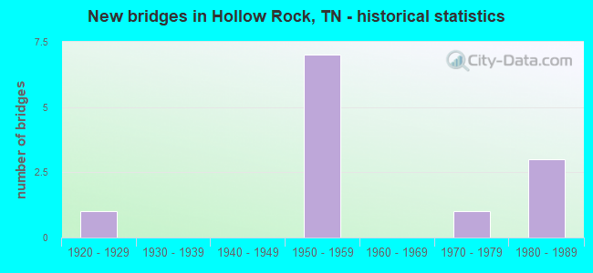
- New bridges - historical statistics
- 11920-1929
- 71950-1959
- 11970-1979
- 31980-1989

- Reconstructed bridges - Historical Statistics
- 11940-1949
- 01950-1959
- 01960-1969
- 01970-1979
- 01980-1989
- 11990-1999


- Bridge Condition - Deck
- 20.0%Good
- 60.0%Satisfactory
- 20.0%Fair

- Bridge Condition - Superstructure
- 20.0%Good
- 80.0%Satisfactory

- Bridge Condition - Substructure
- 20.0%Good
- 40.0%Satisfactory
- 20.0%Fair
- 20.0%Serious

- Bridge Condition - Channel
- 36.4%Good
- 63.6%Satisfactory

- Bridge Condition - Culverts
- 14.3%Good
- 28.6%Satisfactory
- 57.1%Fair
Find on map >> Show street view
Structure Number: 90A3460001, Location: 3.8 MI NE JCT SR77&SR219 (Lat: 36.089278, Lng: -88.282083), Route carried "on" structure: County highway 1746, Year Built: 1984, Status: Open, Structure Length: 1.22m (4.00ft), Average Daily Traffic: 338 (year 2020), Truck Traffic: 3%, Average Future Daily Traffic: 320 (year 2039), Design Load: HS 20, Features Intersected: ALLAN CREEK
Minimum Vertical Clearance: 30+ m (98+ ft), Kilometerpoint: 6.309, Lanes on structure: 2, Owner: County Highway Agency, Approaching Roadway Width: 7.3m (24.0ft), Skew: 1 degrees, Material/Design: Concrete continuous, Design/Construction: Culvert, Number Of Spans In Main Unit: 3, Length of Maximum Span: 3.7m (12.1ft), Curb-To-Curb Width: 6.6m (21.7ft), Out-to-Out Width: 8.8m (28.9ft)
Condition: Channel: Good, Culverts: Satisfactory, Operating Rating: 45.0 metric tons, Method Used To Determine Operating Rating: Load Factor (LF), Inventory Rating: 27.9 metric tons, Method Used To Determine Inventory Rating: Load Factor (LF), Structural Evaluation: Equal to present minimum criteria, Deck Geometry: Meets minimum limits, Waterway Adequacy: Equal to present minimum criteria, Approach Roadway Alignment: Equal to present desirable criteria, Designated Inspection Frequency: Every 24 months, Inspection Date: August 2021, Deck Structure Type: Concrete Cast-file-Place, Wearing Surface/Protective System: Wearing Surface: Monolithic Concrete
Find on map >> Show street view
Structure Number: 90A3860001, Location: IN CITY OF HOLLOW ROCK (Lat: 36.037472, Lng: -88.275139), Route carried "on" structure: City street 386, Year Built: 1984, Status: Open, Structure Length: 1.46m (4.79ft), Average Daily Traffic: 70 (year 2022), Truck Traffic: 8%, Average Future Daily Traffic: 112 (year 2039), Design Load: HS 20, Features Intersected: HOLLOW ROCK BRANCH
Minimum Vertical Clearance: 30+ m (98+ ft), Kilometerpoint: 0.415, Lanes on structure: 2, Owner: City or Municipal Highway Agency, Approaching Roadway Width: 7.3m (24.0ft), Material/Design: Concrete continuous, Design/Construction: Culvert, Number Of Spans In Main Unit: 3, Length of Maximum Span: 4.6m (15.1ft), Curb-To-Curb Width: 6.6m (21.7ft), Out-to-Out Width: 7.7m (25.3ft)
Condition: Channel: Satisfactory, Culverts: Good, Operating Rating: 74.7 metric tons, Method Used To Determine Operating Rating: Load Factor (LF), Inventory Rating: 32.4 metric tons, Method Used To Determine Inventory Rating: Load Factor (LF), Structural Evaluation: Better than present minimum criteria, Deck Geometry: Somewhat better than minimum adequacy, Waterway Adequacy: Better than present minimum criteria, Approach Roadway Alignment: Equal to present desirable criteria, Designated Inspection Frequency: Every 24 months, Inspection Date: August 2021, Deck Structure Type: Concrete Cast-file-Place, Wearing Surface/Protective System: Wearing Surface: Monolithic Concrete
Find on map >> Show street view
Structure Number: 90A3930001, Location: IN CITY OF HOLLOW ROCK (Lat: 36.039222, Lng: -88.281361), Route carried "on" structure: City street 393, Year Built: 1970, Year Reconstructed: 1998, Status: Closed, Structure Length: 0.98m (3.22ft), Average Daily Traffic: 20 (year 2022), Truck Traffic: 2%, Average Future Daily Traffic: 32 (year 2042), Features Intersected: HOLLOW ROCK BRANCH
Minimum Vertical Clearance: 30+ m (98+ ft), Kilometerpoint: 0.554, Lanes on structure: 1, Owner: City or Municipal Highway Agency, Approaching Roadway Width: 4.9m (16.1ft), Material/Design: Steel, Design/Construction: Stringer/Multi-beam, Number Of Spans In Main Unit: 1, Length of Maximum Span: 4.6m (15.1ft), Curb-To-Curb Width: 3.7m (12.1ft), Out-to-Out Width: 3.7m (12.1ft)
Condition: Deck: Fair, Superstructure: Satisfactory, Substructure: Serious, Channel: Satisfactory, Operating Rating: 3.6 metric tons, Method Used To Determine Operating Rating: Load and Resistance Factor Rating (LRFR) rating reported by rating factor(RF) method using HL-93 loadings, Inventory Rating: 2.9 metric tons, Method Used To Determine Inventory Rating: Load and Resistance Factor Rating (LRFR) rating reported by rating factor(RF) method using HL-93 loadings, Deck Geometry: Meets minimum limits, Waterway Adequacy: Somewhat better than minimum adequacy, Approach Roadway Alignment: Equal to present desirable criteria, Bridge Posting: Required (Relationship of Operating Rating to Maximum Legal Load: 10.0 - 19.9% below), Length Of Structure Improvement: 1.65m (5.41ft), Designated Inspection Frequency: Every 24 months, Inspection Date: August 2021, Bridge Improvement Cost: $291,000, Roadway Improvement Cost: $30,000, Total Project Cost: $437,000 ( Estimate for 2022), Deck Structure Type: Wood or Timber, Wearing Surface/Protective System: Wearing Surface: Wood or Timber
Find on map >> Show street view
Structure Number: 9S80240013, Location: IN HOLLOW ROCK (Lat: 36.037111, Lng: -88.273861), Route carried "on" structure: State highway 114, Year Built: 1954, Status: Open, Structure Length: 1.49m (4.89ft), Average Daily Traffic: 824 (year 2020), Truck Traffic: 5%, Average Future Daily Traffic: 1,360 (year 2039), Design Load: H 15, Features Intersected: HOLLOW ROCK CREEK
Minimum Vertical Clearance: 30+ m (98+ ft), Kilometerpoint: 33.684, Lanes on structure: 2, Owner: State Highway Agency, Approaching Roadway Width: 7.3m (24.0ft), Material/Design: Concrete continuous, Design/Construction: Culvert, Number Of Spans In Main Unit: 3, Length of Maximum Span: 4.6m (15.1ft), Curb-To-Curb Width: 6.8m (22.3ft), Out-to-Out Width: 8.1m (26.6ft)
Condition: Channel: Satisfactory, Culverts: Fair, Operating Rating: 42.3 metric tons, Method Used To Determine Operating Rating: Load Factor (LF), Inventory Rating: 25.2 metric tons, Method Used To Determine Inventory Rating: Load Factor (LF), Structural Evaluation: Somewhat better than minimum adequacy, Deck Geometry: Meets minimum limits, Waterway Adequacy: Equal to present minimum criteria, Approach Roadway Alignment: Equal to present desirable criteria, Length Of Structure Improvement: 1.49m (4.89ft), Designated Inspection Frequency: Every 24 months, Inspection Date: July 2021, Bridge Improvement Cost: $84,000, Roadway Improvement Cost: $9,000, Total Project Cost: $127,000 ( Estimate for 2019), Deck Structure Type: Concrete Cast-file-Place, Wearing Surface/Protective System: Wearing Surface: Bituminous
Find on map >> Show street view
Structure Number: 9S80240015, Location: N.OF HOLLOW PARK (Lat: 36.051389, Lng: -88.272167), Route carried "on" structure: State highway 114, Year Built: 1955, Status: Open, Structure Length: 1.01m (3.31ft), Average Daily Traffic: 824 (year 2020), Truck Traffic: 5%, Average Future Daily Traffic: 1,360 (year 2039), Design Load: H 15, Features Intersected: CHERRY CREEK
Minimum Vertical Clearance: 30+ m (98+ ft), Kilometerpoint: 35.293, Lanes on structure: 2, Owner: State Highway Agency, Approaching Roadway Width: 6.7m (22.0ft), Material/Design: Concrete continuous, Design/Construction: Culvert, Number Of Spans In Main Unit: 3, Length of Maximum Span: 3.0m (9.8ft), Curb-To-Curb Width: 6.7m (22.0ft), Out-to-Out Width: 8.2m (26.9ft)
Condition: Channel: Satisfactory, Culverts: Satisfactory, Operating Rating: 38.7 metric tons, Method Used To Determine Operating Rating: Load Factor (LF), Inventory Rating: 22.5 metric tons, Method Used To Determine Inventory Rating: Load Factor (LF), Structural Evaluation: Equal to present minimum criteria, Deck Geometry: Meets minimum limits, Waterway Adequacy: Equal to present desirable criteria, Approach Roadway Alignment: Equal to present desirable criteria, Length Of Structure Improvement: 1.01m (3.31ft), Designated Inspection Frequency: Every 24 months, Inspection Date: July 2021, Bridge Improvement Cost: $61,000, Roadway Improvement Cost: $7,000, Total Project Cost: $92,000 ( Estimate for 2019), Deck Structure Type: Concrete Cast-file-Place, Wearing Surface/Protective System: Wearing Surface: Bituminous
Find on map >> Show street view
Structure Number: 9S80240017, Location: 3 MI N OF HOLLOW ROCK (Lat: 36.074139, Lng: -88.265889), Route carried "on" structure: State highway 114, Year Built: 1950, Status: Open, Structure Length: 1.49m (4.89ft), Average Daily Traffic: 824 (year 2020), Truck Traffic: 5%, Average Future Daily Traffic: 1,360 (year 2039), Design Load: H 15, Features Intersected: ALLEN CREEK
Minimum Vertical Clearance: 30+ m (98+ ft), Kilometerpoint: 38.061, Lanes on structure: 2, Owner: State Highway Agency, Approaching Roadway Width: 6.7m (22.0ft), Material/Design: Concrete continuous, Design/Construction: Culvert, Number Of Spans In Main Unit: 3, Length of Maximum Span: 4.6m (15.1ft), Curb-To-Curb Width: 6.7m (22.0ft), Out-to-Out Width: 8.1m (26.6ft)
Condition: Channel: Satisfactory, Culverts: Fair, Operating Rating: 36.0 metric tons, Method Used To Determine Operating Rating: Load Factor (LF), Inventory Rating: 24.3 metric tons, Method Used To Determine Inventory Rating: Load Factor (LF), Structural Evaluation: Somewhat better than minimum adequacy, Deck Geometry: Meets minimum limits, Waterway Adequacy: Equal to present minimum criteria, Approach Roadway Alignment: Equal to present desirable criteria, Length Of Structure Improvement: 1.49m (4.89ft), Designated Inspection Frequency: Every 24 months, Inspection Date: July 2021, Bridge Improvement Cost: $84,000, Roadway Improvement Cost: $9,000, Total Project Cost: $127,000 ( Estimate for 2019), Deck Structure Type: Concrete Cast-file-Place, Wearing Surface/Protective System: Wearing Surface: Bituminous
Find on map >> Show street view
Structure Number: 9S81460009, Location: 2.6 MI.S.OF HOLLOW ROCK (Lat: 35.995722, Lng: -88.278250), Route carried "on" structure: State highway 114, Year Built: 1959, Status: Posted for load, Structure Length: 2.32m (7.61ft), Average Daily Traffic: 683 (year 2020), Truck Traffic: 4%, Average Future Daily Traffic: 1,168 (year 2039), Design Load: H 15, Features Intersected: MOORE CREEK
Minimum Vertical Clearance: 30+ m (98+ ft), Kilometerpoint: 29.065, Lanes on structure: 2, Owner: State Highway Agency, Approaching Roadway Width: 9.4m (30.8ft), Material/Design: Concrete, Design/Construction: Channel Beam, Number Of Spans In Main Unit: 4, Length of Maximum Span: 5.8m (19.0ft), Curb-To-Curb Width: 7.3m (24.0ft), Out-to-Out Width: 7.7m (25.3ft)
Condition: Deck: Satisfactory, Superstructure: Satisfactory, Substructure: Satisfactory, Channel: Satisfactory, Operating Rating: 45.9 metric tons, Method Used To Determine Operating Rating: Load Factor (LF), Inventory Rating: 27.9 metric tons, Method Used To Determine Inventory Rating: Load Factor (LF), Structural Evaluation: Equal to present minimum criteria, Deck Geometry: Meets minimum limits, Waterway Adequacy: Equal to present minimum criteria, Approach Roadway Alignment: Equal to present desirable criteria, Length Of Structure Improvement: 2.32m (7.61ft), Designated Inspection Frequency: Every 24 months, Inspection Date: July 2021, Bridge Improvement Cost: $157,000, Roadway Improvement Cost: $16,000, Total Project Cost: $236,000 ( Estimate for 2019), Deck Structure Type: Concrete Precast Panels, Wearing Surface/Protective System: Wearing Surface: Bituminous
Find on map >> Show street view
Structure Number: 9SR0010027, Location: 1.5 MI.N.OF HOLLOW ROCK (Lat: 36.037889, Lng: -88.308972), Route carried "on" structure: US 70, Year Built: 1950, Status: Open, Structure Length: 0.98m (3.22ft), Average Daily Traffic: 5,117 (year 2020), Truck Traffic: 7%, Average Future Daily Traffic: 8,544 (year 2039), Design Load: HS 20, Features Intersected: BRANCH, Facility Carried by Structure: FAP 1
Minimum Vertical Clearance: 30+ m (98+ ft), Kilometerpoint: 43.340, Lanes on structure: 2, Base Highway Network: Yes, Owner: State Highway Agency, Approaching Roadway Width: 12.2m (40.0ft), Skew: 4 degrees, Material/Design: Concrete continuous, Design/Construction: Culvert, Number Of Spans In Main Unit: 2, Length of Maximum Span: 3.0m (9.8ft)
Condition: Channel: Good, Culverts: Fair, Operating Rating: 44.1 metric tons, Method Used To Determine Operating Rating: Load Factor (LF), Inventory Rating: 24.3 metric tons, Method Used To Determine Inventory Rating: Load Factor (LF), Structural Evaluation: Somewhat better than minimum adequacy, Waterway Adequacy: Equal to present desirable criteria, Approach Roadway Alignment: Equal to present desirable criteria, Length Of Structure Improvement: 0.98m (3.22ft), Designated Inspection Frequency: Every 24 months, Inspection Date: July 2021, Bridge Improvement Cost: $221,000, Roadway Improvement Cost: $23,000, Total Project Cost: $332,000 ( Estimate for 2019)
Find on map >> Show street view
Structure Number: 9SR0010029, Location: IN HOLLOW ROCK (Lat: 36.037944, Lng: -88.291972), Route carried "on" structure: US 70, Year Built: 1928, Year Reconstructed: 1953, Status: Posted for load, Structure Length: 1.25m (4.10ft), Average Daily Traffic: 5,117 (year 2020), Truck Traffic: 7%, Average Future Daily Traffic: 8,544 (year 2039), Design Load: H 15, Features Intersected: BRANCH, Facility Carried by Structure: FAP 1
Minimum Vertical Clearance: 30+ m (98+ ft), Kilometerpoint: 44.869, Lanes on structure: 2, Base Highway Network: Yes, Owner: State Highway Agency, Approaching Roadway Width: 13.4m (44.0ft), Skew: 3 degrees, Material/Design: Concrete, Design/Construction: Tee Beam, Number Of Spans In Main Unit: 2, Length of Maximum Span: 7.6m (24.9ft), Curb-To-Curb Width: 13.5m (44.3ft), Out-to-Out Width: 15.4m (50.5ft)
Condition: Deck: Satisfactory, Superstructure: Satisfactory, Substructure: Satisfactory, Channel: Good, Operating Rating: 45.0 metric tons, Method Used To Determine Operating Rating: Load Factor (LF), Inventory Rating: 27.0 metric tons, Method Used To Determine Inventory Rating: Load Factor (LF), Structural Evaluation: Equal to present minimum criteria, Deck Geometry: Superior to present desirable criteria, Waterway Adequacy: Equal to present minimum criteria, Approach Roadway Alignment: Equal to present desirable criteria, Length Of Structure Improvement: 1.25m (4.10ft), Designated Inspection Frequency: Every 24 months, Inspection Date: July 2021, Bridge Improvement Cost: $301,000, Roadway Improvement Cost: $31,000, Total Project Cost: $452,000 ( Estimate for 2019), Deck Structure Type: Concrete Cast-file-Place, Wearing Surface/Protective System: Wearing Surface: Bituminous
Find on map >> Show street view
Structure Number: 9SR0010031, Location: IN HOLLOW ROCK (Lat: 36.034472, Lng: -88.280167), Route carried "on" structure: US 70, Year Built: 1950, Status: Open, Structure Length: 0.73m (2.40ft), Average Daily Traffic: 5,117 (year 2020), Truck Traffic: 7%, Average Future Daily Traffic: 8,544 (year 2039), Design Load: HS 20, Features Intersected: BRANCH, Facility Carried by Structure: FAP 1
Minimum Vertical Clearance: 30+ m (98+ ft), Kilometerpoint: 45.963, Lanes on structure: 2, Base Highway Network: Yes, Owner: State Highway Agency, Approaching Roadway Width: 13.1m (43.0ft), Skew: 1 degrees, Material/Design: Concrete continuous, Design/Construction: Culvert, Number Of Spans In Main Unit: 2, Length of Maximum Span: 3.0m (9.8ft)
Condition: Channel: Good, Culverts: Fair, Operating Rating: 44.1 metric tons, Method Used To Determine Operating Rating: Load Factor (LF), Inventory Rating: 24.3 metric tons, Method Used To Determine Inventory Rating: Load Factor (LF), Structural Evaluation: Somewhat better than minimum adequacy, Waterway Adequacy: Equal to present desirable criteria, Approach Roadway Alignment: Equal to present desirable criteria, Length Of Structure Improvement: 0.73m (2.40ft), Designated Inspection Frequency: Every 24 months, Inspection Date: July 2021, Bridge Improvement Cost: $172,000, Roadway Improvement Cost: $18,000, Total Project Cost: $259,000 ( Estimate for 2019)
Find on map >> Show street view
Structure Number: 9SR0010033, Location: IN HOLLOW ROCK (Lat: 36.034222, Lng: -88.278833), Route carried "on" structure: US 70, Year Built: 1950, Status: Open, Structure Length: 3.02m (9.91ft), Average Daily Traffic: 5,117 (year 2020), Truck Traffic: 7%, Average Future Daily Traffic: 8,544 (year 2039), Design Load: HS 20+Mod, Features Intersected: CSX RR (ABANDONED), Facility Carried by Structure: FAP 1
Minimum Vertical Clearance: 30+ m (98+ ft), Kilometerpoint: 46.092, Lanes on structure: 4, Base Highway Network: Yes, Owner: State Highway Agency, Approaching Roadway Width: 18.3m (60.0ft), Material/Design: Concrete, Design/Construction: Tee Beam, Number Of Spans In Main Unit: 3, Length of Maximum Span: 10.1m (33.1ft), Curb or Sidewalk Widths: Left: 1.5m (4.9ft), Right: 1.5m (4.9ft), Curb-To-Curb Width: 15.8m (51.8ft), Out-to-Out Width: 19.5m (64.0ft)
Condition: Deck: Satisfactory, Superstructure: Satisfactory, Substructure: Fair, Operating Rating: 76.5 metric tons, Method Used To Determine Operating Rating: Load Factor (LF), Inventory Rating: 32.4 metric tons, Method Used To Determine Inventory Rating: Load Factor (LF), Structural Evaluation: Somewhat better than minimum adequacy, Deck Geometry: Meets minimum limits, Approach Roadway Alignment: Equal to present desirable criteria, Length Of Structure Improvement: 3.02m (9.91ft), Designated Inspection Frequency: Every 24 months, Inspection Date: July 2021, Bridge Improvement Cost: $213,000, Roadway Improvement Cost: $22,000, Total Project Cost: $320,000 ( Estimate for 2019), Deck Structure Type: Concrete Cast-file-Place, Wearing Surface/Protective System: Wearing Surface: Bituminous
Find on map >> Show street view
Structure Number: 230A7040001, Location: 2 MI N OF SR104 (Lat: 36.058944, Lng: -88.294528), Route carried "on" structure: County highway 2926, Year Built: 1981, Status: Posted for load, Structure Length: 1.37m (4.49ft), Average Daily Traffic: 1,004 (year 2020), Truck Traffic: 3%, Average Future Daily Traffic: 1,728 (year 2040), Design Load: HS 20, Features Intersected: BRANCH
Minimum Vertical Clearance: 30+ m (98+ ft), Kilometerpoint: 7.129, Lanes on structure: 2, Owner: County Highway Agency, Approaching Roadway Width: 5.5m (18.0ft), Material/Design: Prestressed concrete, Design/Construction: Box Beam or Girders - Multiple, Number Of Spans In Main Unit: 1, Length of Maximum Span: 13.7m (44.9ft), Curb-To-Curb Width: 8.3m (27.2ft), Out-to-Out Width: 9.4m (30.8ft)
Condition: Deck: Good, Superstructure: Good, Substructure: Good, Channel: Satisfactory, Operating Rating: 44.1 metric tons, Method Used To Determine Operating Rating: Assigned rating based on Load Factor Design (LFD) reported in metric tons, Inventory Rating: 32.4 metric tons, Method Used To Determine Inventory Rating: Assigned rating based on Load Factor Design (LFD) reported in metric tons, Structural Evaluation: Better than present minimum criteria, Deck Geometry: Meets minimum limits, Waterway Adequacy: Equal to present minimum criteria, Approach Roadway Alignment: Equal to present desirable criteria, Designated Inspection Frequency: Every 24 months, Inspection Date: November 2021, Deck Structure Type: Concrete Cast-file-Place, Wearing Surface/Protective System: Wearing Surface: Bituminous