Bridge Statistics for Hollywood, Alabama (AL)
Condition, Traffic, Stress, Structural Evaluation, Project Costs
- National Bridge Inventory (NBI) Statistics
- 12Number of bridges
- 148ft / 45.3mTotal length
- $14,602,000Total costs
- 46,370Total average daily traffic
- 5,859Total average daily truck traffic
- National Bridge Inventory (NBI) Registered Bridges for Hollywood
- No street view available for this location
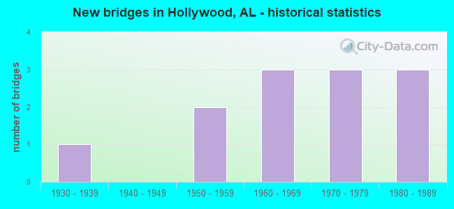
- New bridges - historical statistics
- 11930-1939
- 21950-1959
- 31960-1969
- 31970-1979
- 31980-1989


- Bridge Condition - Deck
- 28.6%Good
- 57.1%Satisfactory
- 14.3%Fair

- Bridge Condition - Superstructure
- 14.3%Very good
- 57.1%Good
- 14.3%Satisfactory
- 14.3%Fair

- Bridge Condition - Substructure
- 85.7%Good
- 14.3%Fair

- Bridge Condition - Channel
- 25.0%Good
- 75.0%Satisfactory

- Bridge Condition - Culverts
- 25.0%Good
- 50.0%Satisfactory
- 25.0%Fair
Find on map >> Show street view
Structure Number: BLN0BR001, Location: Bellefonte (Lat: 34.729722, Lng: -85.915833), Route carried "on" structure: ServiceOther road , Year Built: 1974, Status: Open, Structure Length: 0.64m (2.10ft), Average Daily Traffic: 250 (year 2021), Truck Traffic: 1%, Average Future Daily Traffic: 500 (year 2041), Design Load: H 20, Features Intersected: TOWN CREEK, Facility Carried by Structure: BELLEFONTE ROAD
Minimum Vertical Clearance: 30+ m (98+ ft), Kilometerpoint: 0.000, Lanes on structure: 2, Owner: Tennessee Valley Authority, Approaching Roadway Width: 12.8m (42.0ft), Material/Design: Concrete, Design/Construction: Culvert, Number Of Spans In Main Unit: 2, Length of Maximum Span: 3.0m (9.8ft)
Condition: Channel: Good, Culverts: Satisfactory, Operating Rating: 37.3 metric tons, Method Used To Determine Operating Rating: Load and Resistance Factor (LRFR), Inventory Rating: 28.8 metric tons, Method Used To Determine Inventory Rating: Load and Resistance Factor (LRFR), Structural Evaluation: Equal to present minimum criteria, Waterway Adequacy: Better than present minimum criteria, Approach Roadway Alignment: Better than present minimum criteria, Designated Inspection Frequency: Every 24 months, Underwater Inspection Frequency: Every 60 months, Inspection Date: March 2021, Underwater Inspection Date: May 2021, Wearing Surface/Protective System: Wearing Surface: Bituminous
Find on map >> Show street view
Structure Number: 2002, Location: 1.1 MI NW US 72 (Lat: 34.725000, Lng: -85.973689), Route carried "on" structure: County highway 33, Year Built: 1939, Status: Open, Structure Length: 0.67m (2.20ft), Average Daily Traffic: 840 (year 1989), Truck Traffic: 30%, Average Future Daily Traffic: 960 (year 2039), Design Load: H 10, Features Intersected: BRANCH
Minimum Vertical Clearance: 30+ m (98+ ft), Kilometerpoint: 0.010, Lanes on structure: 2, Owner: County Highway Agency, Approaching Roadway Width: 11.0m (36.1ft), Material/Design: Masonry, Design/Construction: Culvert, Number Of Spans In Main Unit: 2, Length of Maximum Span: 3.0m (9.8ft)
Condition: Channel: Satisfactory, Culverts: Satisfactory, Operating Rating: 32.7 metric tons, Method Used To Determine Operating Rating: Field evaluation and documented engineering judgment, Inventory Rating: 23.6 metric tons, Method Used To Determine Inventory Rating: Field evaluation and documented engineering judgment, Structural Evaluation: Equal to present minimum criteria, Waterway Adequacy: Better than present minimum criteria, Approach Roadway Alignment: Better than present minimum criteria, Length Of Structure Improvement: 1.30m (4.27ft), Designated Inspection Frequency: Every 24 months, Inspection Date: November 2021, Bridge Improvement Cost: $383,000, Roadway Improvement Cost: $38,000, Total Project Cost: $421,000 ( Estimate for 2022)
Find on map >> Show street view
Structure Number: 5906, Location: 0.7 MI S JCT CR 39 (Lat: 34.791494, Lng: -85.977844), Route carried "on" structure: County highway 42, Year Built: 1957, Status: Posted for load, Structure Length: 1.46m (4.79ft), Average Daily Traffic: 250 (year 1989), Truck Traffic: 3%, Average Future Daily Traffic: 292 (year 2039), Design Load: H 10, Features Intersected: MUD CREEK
Minimum Vertical Clearance: 30+ m (98+ ft), Kilometerpoint: 0.010, Lanes on structure: 2, Owner: County Highway Agency, Approaching Roadway Width: 7.3m (24.0ft), Material/Design: Wood or Timber, Design/Construction: Stringer/Multi-beam, Number Of Spans In Main Unit: 3, Length of Maximum Span: 4.9m (16.1ft), Curb-To-Curb Width: 6.6m (21.7ft), Out-to-Out Width: 7.6m (24.9ft)
Condition: Deck: Fair, Superstructure: Fair, Substructure: Fair, Channel: Satisfactory, Operating Rating: 26.2 metric tons, Method Used To Determine Operating Rating: Allowable Stress (AS), Inventory Rating: 18.1 metric tons, Method Used To Determine Inventory Rating: Allowable Stress (AS), Structural Evaluation: Somewhat better than minimum adequacy, Deck Geometry: Meets minimum limits, Waterway Adequacy: Somewhat better than minimum adequacy, Approach Roadway Alignment: Equal to present desirable criteria, Bridge Posting: Required (Relationship of Operating Rating to Maximum Legal Load: 30.0 - 39.9% below), Length Of Structure Improvement: 2.14m (7.02ft), Designated Inspection Frequency: Every 24 months, Other Special Inspection Frequency: Every 12 months, Inspection Date: October 2021, Other Special Inspection Date: October 2021, Bridge Improvement Cost: $352,000, Roadway Improvement Cost: $35,000, Total Project Cost: $387,000 ( Estimate for 2022), Deck Structure Type: Concrete Cast-file-Place, Wearing Surface/Protective System: Wearing Surface: Other
Find on map >> Show street view
Structure Number: 6608, Location: 4.0 MI S JCT US 72 (Lat: 34.683233, Lng: -85.978456), Route carried "on" structure: County highway 33, Year Built: 1959, Status: Open, Structure Length: 1.92m (6.30ft), Average Daily Traffic: 790 (year 1989), Truck Traffic: 15%, Average Future Daily Traffic: 940 (year 2039), Design Load: H 10, Features Intersected: DRY CREEK
Minimum Vertical Clearance: 30+ m (98+ ft), Kilometerpoint: 0.010, Lanes on structure: 2, Owner: County Highway Agency, Approaching Roadway Width: 7.3m (24.0ft), Material/Design: Concrete, Design/Construction: Culvert, Number Of Spans In Main Unit: 5, Length of Maximum Span: 4.0m (13.1ft), Curb-To-Curb Width: 8.0m (26.2ft), Out-to-Out Width: 9.1m (29.9ft)
Condition: Channel: Satisfactory, Culverts: Fair, Operating Rating: 41.8 metric tons, Method Used To Determine Operating Rating: Load Factor (LF), Inventory Rating: 25.0 metric tons, Method Used To Determine Inventory Rating: Load Factor (LF), Structural Evaluation: Somewhat better than minimum adequacy, Deck Geometry: Somewhat better than minimum adequacy, Waterway Adequacy: Equal to present minimum criteria, Approach Roadway Alignment: Better than present minimum criteria, Length Of Structure Improvement: 2.65m (8.69ft), Designated Inspection Frequency: Every 24 months, Inspection Date: November 2021, Bridge Improvement Cost: $429,000, Roadway Improvement Cost: $43,000, Total Project Cost: $472,000 ( Estimate for 2022)
Find on map >> Show street view
Structure Number: 7977, Location: 0.7 M S JCT US 72 (Lat: 34.713275, Lng: -85.947772), Route carried "on" structure: County highway 33, Year Built: 1963, Year Reconstructed: 1994, Status: Open, Structure Length: 1.10m (3.61ft), Average Daily Traffic: 805 (year 1989), Truck Traffic: 10%, Average Future Daily Traffic: 933 (year 2039), Design Load: HS 20, Features Intersected: TOWN CREEK
Minimum Vertical Clearance: 30+ m (98+ ft), Kilometerpoint: 0.010, Lanes on structure: 2, Owner: County Highway Agency, Approaching Roadway Width: 10.4m (34.1ft), Material/Design: Concrete, Design/Construction: Culvert, Number Of Spans In Main Unit: 3, Length of Maximum Span: 3.7m (12.1ft), Curb-To-Curb Width: 11.0m (36.1ft), Out-to-Out Width: 11.7m (38.4ft)
Condition: Channel: Good, Culverts: Good, Operating Rating: 81.6 metric tons, Method Used To Determine Operating Rating: Load Factor (LF), Inventory Rating: 49.0 metric tons, Method Used To Determine Inventory Rating: Load Factor (LF), Structural Evaluation: Better than present minimum criteria, Deck Geometry: Better than present minimum criteria, Waterway Adequacy: Equal to present desirable criteria, Approach Roadway Alignment: Better than present minimum criteria, Length Of Structure Improvement: 1.77m (5.81ft), Designated Inspection Frequency: Every 24 months, Inspection Date: November 2021, Bridge Improvement Cost: $389,000, Roadway Improvement Cost: $39,000, Total Project Cost: $428,000 ( Estimate for 2022)
Find on map >> Show street view
Structure Number: 9369, Location: 1.0 MI S JCT CR 42 (Lat: 34.787900, Lng: -85.977164), Route carried "on" structure: County highway 42, Year Built: 1967, Status: Posted for load, Structure Length: 4.94m (16.21ft), Average Daily Traffic: 250 (year 1989), Truck Traffic: 3%, Average Future Daily Traffic: 303 (year 2039), Design Load: H 10, Features Intersected: MUD CREEK
Minimum Vertical Clearance: 30+ m (98+ ft), Kilometerpoint: 0.010, Lanes on structure: 2, Owner: County Highway Agency, Approaching Roadway Width: 7.3m (24.0ft), Material/Design: Steel, Design/Construction: Stringer/Multi-beam, Number Of Spans In Main Unit: 3, Length of Maximum Span: 16.5m (54.1ft), Curb-To-Curb Width: 6.7m (22.0ft), Out-to-Out Width: 7.8m (25.6ft)
Condition: Deck: Satisfactory, Superstructure: Satisfactory, Substructure: Good, Channel: Satisfactory, Operating Rating: 19.1 metric tons, Method Used To Determine Operating Rating: Allowable Stress (AS), Inventory Rating: 10.9 metric tons, Method Used To Determine Inventory Rating: Allowable Stress (AS), Structural Evaluation: Meets minimum limits, Deck Geometry: Meets minimum limits, Waterway Adequacy: Equal to present minimum criteria, Approach Roadway Alignment: Somewhat better than minimum adequacy, Bridge Posting: Required (Relationship of Operating Rating to Maximum Legal Load: > 39.9% below), Length Of Structure Improvement: 5.96m (19.55ft), Designated Inspection Frequency: Every 24 months, Other Special Inspection Frequency: Every 12 months, Inspection Date: October 2021, Other Special Inspection Date: October 2021, Bridge Improvement Cost: $1,021,000, Roadway Improvement Cost: $102,000, Total Project Cost: $1,123,000 ( Estimate for 2022), Deck Structure Type: Concrete Cast-file-Place
Find on map >> Show street view
Structure Number: 996, Location: E CITY LIMIT SCOTTSBORO (Lat: 34.698728, Lng: -85.983589), Route carried "on" structure: US 72, Year Built: 1969, Status: Open, Structure Length: 7.25m (23.79ft), Average Daily Traffic: 6,762 (year 2019), Truck Traffic: 12%, Average Future Daily Traffic: 9,467 (year 2039), Design Load: HS 20, Features Intersected: DRY CREEK
Minimum Vertical Clearance: 30+ m (98+ ft), Kilometerpoint: 227.769, Lanes on structure: 2, Owner: State Highway Agency, Approaching Roadway Width: 7.3m (24.0ft), Skew: 10 degrees, Material/Design: Concrete, Design/Construction: Tee Beam, Number Of Spans In Main Unit: 7, Length of Maximum Span: 10.4m (34.1ft), Curb or Sidewalk Widths: Left: 0.2m (0.7ft), Right: 0.2m (0.7ft), Curb-To-Curb Width: 13.4m (44.0ft), Out-to-Out Width: 14.5m (47.6ft)
Condition: Deck: Satisfactory, Superstructure: Good, Substructure: Good, Channel: Satisfactory, Operating Rating: 44.5 metric tons, Method Used To Determine Operating Rating: Load Factor (LF), Inventory Rating: 26.7 metric tons, Method Used To Determine Inventory Rating: Load Factor (LF), Structural Evaluation: Equal to present minimum criteria, Deck Geometry: Superior to present desirable criteria, Waterway Adequacy: Equal to present minimum criteria, Approach Roadway Alignment: Equal to present minimum criteria, Length Of Structure Improvement: 8.28m (27.17ft), Designated Inspection Frequency: Every 24 months, Inspection Date: October 2020, Bridge Improvement Cost: $2,668,000, Roadway Improvement Cost: $267,000, Total Project Cost: $2,935,000 ( Estimate for 2022), Deck Structure Type: Concrete Cast-file-Place
Find on map >> Show street view
Structure Number: 11786, Location: 2.5 MI E JCT SR279 * US72 (Lat: 34.728853, Lng: -85.942506), Route carried "on" structure: US 72, Year Built: 1977, Status: Open, Structure Length: 4.21m (13.81ft), Average Daily Traffic: 7,238 (year 2020), Truck Traffic: 13%, Average Future Daily Traffic: 10,133 (year 2040), Design Load: HS 20, Features Intersected: ABANDONED RR SPUR
Minimum Vertical Clearance: 30+ m (98+ ft), Kilometerpoint: 232.909, Lanes on structure: 2, Owner: State Highway Agency, Approaching Roadway Width: 7.3m (24.0ft), Skew: 11 degrees, Material/Design: Steel continuous, Design/Construction: Stringer/Multi-beam, Number Of Spans In Main Unit: 3, Length of Maximum Span: 15.2m (49.9ft), Curb or Sidewalk Widths: Left: 0.4m (1.3ft), Right: 0.4m (1.3ft), Curb-To-Curb Width: 12.0m (39.4ft), Out-to-Out Width: 12.8m (42.0ft)
Condition: Deck: Satisfactory, Superstructure: Good, Substructure: Good, Operating Rating: 62.8 metric tons, Method Used To Determine Operating Rating: Load Factor (LF), Inventory Rating: 37.6 metric tons, Method Used To Determine Inventory Rating: Load Factor (LF), Structural Evaluation: Better than present minimum criteria, Deck Geometry: Better than present minimum criteria, Underclear: Equal to present minimum criteria, Approach Roadway Alignment: Equal to present desirable criteria, Length Of Structure Improvement: 5.18m (16.99ft), Designated Inspection Frequency: Every 24 months, Inspection Date: January 2022, Bridge Improvement Cost: $1,492,000, Roadway Improvement Cost: $149,000, Total Project Cost: $1,641,000 ( Estimate for 2022), Deck Structure Type: Concrete Cast-file-Place
Find on map >> Show street view
Structure Number: 11787, Location: 2.5 MI E JCT SR279 * US72 (Lat: 34.728619, Lng: -85.942389), Route carried "on" structure: US 72, Year Built: 1977, Status: Open, Structure Length: 4.21m (13.81ft), Average Daily Traffic: 7,238 (year 2020), Truck Traffic: 13%, Average Future Daily Traffic: 10,133 (year 2040), Design Load: HS 20, Features Intersected: ABANDONED RR SPUR
Minimum Vertical Clearance: 30+ m (98+ ft), Kilometerpoint: 232.909, Lanes on structure: 2, Owner: State Highway Agency, Approaching Roadway Width: 7.3m (24.0ft), Skew: 11 degrees, Material/Design: Steel continuous, Design/Construction: Stringer/Multi-beam, Number Of Spans In Main Unit: 3, Length of Maximum Span: 15.2m (49.9ft), Curb or Sidewalk Widths: Left: 0.4m (1.3ft), Right: 0.4m (1.3ft), Curb-To-Curb Width: 12.0m (39.4ft), Out-to-Out Width: 12.8m (42.0ft)
Condition: Deck: Satisfactory, Superstructure: Good, Substructure: Good, Operating Rating: 62.8 metric tons, Method Used To Determine Operating Rating: Load Factor (LF), Inventory Rating: 37.6 metric tons, Method Used To Determine Inventory Rating: Load Factor (LF), Structural Evaluation: Better than present minimum criteria, Deck Geometry: Better than present minimum criteria, Underclear: Equal to present minimum criteria, Approach Roadway Alignment: Equal to present desirable criteria, Length Of Structure Improvement: 5.18m (16.99ft), Designated Inspection Frequency: Every 24 months, Inspection Date: January 2022, Bridge Improvement Cost: $1,492,000, Roadway Improvement Cost: $149,000, Total Project Cost: $1,641,000 ( Estimate for 2022), Deck Structure Type: Concrete Cast-file-Place
Find on map >> Show street view
Structure Number: 12346, Location: E CITY LIMITS SCOTTSBORO (Lat: 34.698881, Lng: -85.983886), Route carried "on" structure: US 72, Year Built: 1980, Status: Open, Structure Length: 7.25m (23.79ft), Average Daily Traffic: 6,762 (year 2019), Truck Traffic: 13%, Average Future Daily Traffic: 9,467 (year 2039), Design Load: HS 20, Features Intersected: DRY CREEK
Minimum Vertical Clearance: 30+ m (98+ ft), Kilometerpoint: 227.769, Lanes on structure: 2, Owner: State Highway Agency, Approaching Roadway Width: 12.2m (40.0ft), Skew: 10 degrees, Material/Design: Prestressed concrete, Design/Construction: Stringer/Multi-beam, Number Of Spans In Main Unit: 7, Length of Maximum Span: 10.4m (34.1ft), Curb or Sidewalk Widths: Left: 0.4m (1.3ft), Right: 0.4m (1.3ft), Curb-To-Curb Width: 12.2m (40.0ft), Out-to-Out Width: 13.0m (42.7ft)
Condition: Deck: Good, Superstructure: Very good, Substructure: Good, Channel: Satisfactory, Operating Rating: 63.8 metric tons, Method Used To Determine Operating Rating: Load Factor (LF), Inventory Rating: 38.2 metric tons, Method Used To Determine Inventory Rating: Load Factor (LF), Structural Evaluation: Better than present minimum criteria, Deck Geometry: Better than present minimum criteria, Waterway Adequacy: Equal to present minimum criteria, Approach Roadway Alignment: Equal to present desirable criteria, Length Of Structure Improvement: 8.28m (27.17ft), Designated Inspection Frequency: Every 24 months, Inspection Date: October 2020, Bridge Improvement Cost: $2,384,000, Roadway Improvement Cost: $238,000, Total Project Cost: $2,622,000 ( Estimate for 2022), Deck Structure Type: Concrete Cast-file-Place
Find on map >> Show street view
Structure Number: 14027, Location: JCT US 72 * SR 279 (Lat: 34.703944, Lng: -85.979542), Route carried "on" structure: State highway 279, Year Built: 1986, Status: Open, Structure Length: 11.67m (38.29ft), Average Daily Traffic: 1,662 (year 2019), Truck Traffic: 4%, Average Future Daily Traffic: 2,327 (year 2039), Design Load: HS 20, Features Intersected: US 72; SR 2
Minimum Vertical Clearance: 30+ m (98+ ft), Kilometerpoint: 14.829, Lanes on structure: 1, Lanes under structure: 4, Owner: State Highway Agency, Approaching Roadway Width: 8.8m (28.9ft), Skew: 4 degrees, Material/Design: Steel continuous, Design/Construction: Stringer/Multi-beam, Number Of Spans In Main Unit: 2, Number Of Approach Spans: 2, Length of Maximum Span: 76.2m (250.0ft), Curb-To-Curb Width: 8.8m (28.9ft), Out-to-Out Width: 9.7m (31.8ft)
Condition: Deck: Good, Superstructure: Good, Substructure: Good, Operating Rating: 59.4 metric tons, Method Used To Determine Operating Rating: Load Factor (LF), Inventory Rating: 35.6 metric tons, Method Used To Determine Inventory Rating: Load Factor (LF), Structural Evaluation: Better than present minimum criteria, Deck Geometry: Somewhat better than minimum adequacy, Underclear: Better than present minimum criteria, Approach Roadway Alignment: Somewhat better than minimum adequacy, Length Of Structure Improvement: 12.54m (41.14ft), Designated Inspection Frequency: Every 24 months, Inspection Date: March 2021, Bridge Improvement Cost: $2,665,000, Roadway Improvement Cost: $267,000, Total Project Cost: $2,932,000 ( Estimate for 2022), Deck Structure Type: Concrete Cast-file-Place
Find on map >> Show street view
Structure Number: 14027, Location: JCT US 72 * SR 279 (Lat: 34.703944, Lng: -85.979542), Route carried "under" structure: US 72, Year Built: 1986, Structure Length: 0. m, Average Daily Traffic: 13,523 (year 2019), Truck Traffic: 13%, Features Intersected: US 72; SR 2, Facility Carried by Structure: SR 279
Minimum Vertical Clearance: 5.24m (17.19ft), Kilometerpoint: 228.688, Lanes on structure: 1, Lanes under structure: 4, Material/Design: Steel continuous, Design/Construction: Stringer/Multi-beam, Length of Maximum Span: 76.2m (250.0ft)