Bridge Statistics for Homeworth, Ohio (OH)
Condition, Traffic, Stress, Structural Evaluation, Project Costs
- National Bridge Inventory (NBI) Statistics
- 11Number of bridges
- 56ft / 17.3mTotal length
- 10,527Total average daily traffic
- 868Total average daily truck traffic
- 14,612Total future (year 2035) average daily traffic
- National Bridge Inventory (NBI) Registered Bridges for Homeworth
- No street view available for this location
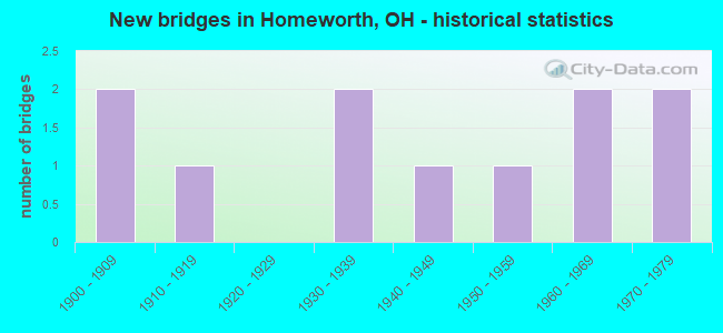
- New bridges - historical statistics
- 21900-1909
- 11910-1919
- 21930-1939
- 11940-1949
- 11950-1959
- 21960-1969
- 21970-1979

- Reconstructed bridges - Historical Statistics
- 11980-1989
- 31990-1999
- 12000-2009
- 12010-2019


- Bridge Condition - Deck
- 10.0%Excellent
- 20.0%Very good
- 20.0%Good
- 30.0%Satisfactory
- 10.0%Fair
- 10.0%Poor

- Bridge Condition - Superstructure
- 10.0%Excellent
- 20.0%Very good
- 20.0%Good
- 10.0%Satisfactory
- 30.0%Fair
- 10.0%Poor

- Bridge Condition - Substructure
- 50.0%Very good
- 10.0%Good
- 20.0%Satisfactory
- 20.0%Fair

- Bridge Condition - Channel
- 50.0%Very good
- 12.5%Good
- 12.5%Satisfactory
- 12.5%Fair
- 12.5%Poor
Find on map >> Show street view
Structure Number: 1504657, Location: 8.07 MI W OF SR 9 (Lat: 40.796631, Lng: -81.070050), Route carried "on" structure: State highway 172, Year Built: 1972, Status: Open, Structure Length: 2.06m (6.76ft), Average Daily Traffic: 3,323 (year 2015), Truck Traffic: 12%, Average Future Daily Traffic: 4,612 (year 2035), Design Load: HS 20+Mod, Features Intersected: M BR SANDY BEAVER CR
Minimum Vertical Clearance: 30+ m (98+ ft), Kilometerpoint: 1.561, Lanes on structure: 2, Owner: State Highway Agency, Approaching Roadway Width: 11.0m (36.1ft), Skew: 1 degrees, Material/Design: Concrete continuous, Design/Construction: Slab, Number Of Spans In Main Unit: 3, Length of Maximum Span: 7.6m (24.9ft), Curb-To-Curb Width: 10.4m (34.1ft), Out-to-Out Width: 10.4m (34.1ft)
Condition: Deck: Fair, Superstructure: Fair, Substructure: Satisfactory, Channel: Very good, Operating Rating: 48.0 metric tons, Method Used To Determine Operating Rating: Load Factor (LF) rating reported by rating factor (RF) method using MS18 loading, Inventory Rating: 28.8 metric tons, Method Used To Determine Inventory Rating: Load Factor (LF) rating reported by rating factor (RF) method using MS18 loading, Structural Evaluation: Somewhat better than minimum adequacy, Deck Geometry: Somewhat better than minimum adequacy, Waterway Adequacy: Equal to present desirable criteria, Approach Roadway Alignment: Equal to present desirable criteria, Designated Inspection Frequency: Every 12 months, Inspection Date: June 2021, Deck Structure Type: Concrete Cast-file-Place, Wearing Surface/Protective System: Wearing Surface: Bituminous, Membrane: Epoxy
Find on map >> Show street view
Structure Number: 1531115, Location: 0.0 MI N C400 (Lat: 40.835731, Lng: -81.068461), Route carried "on" structure: County highway C0401, Year Built: 1968, Year Reconstructed: 2016, Status: Open, Structure Length: 0.76m (2.49ft), Average Daily Traffic: 1,065 (year 2015), Truck Traffic: 8%, Average Future Daily Traffic: 1,478 (year 2035), Design Load: HS 20, Features Intersected: NO NAME STREAM, Facility Carried by Structure: HOMEWORTH RD 401
Minimum Vertical Clearance: 30+ m (98+ ft), Kilometerpoint: 0.467, Lanes on structure: 2, Owner: County Highway Agency, Approaching Roadway Width: 8.8m (28.9ft), Material/Design: Steel, Design/Construction: Stringer/Multi-beam, Number Of Spans In Main Unit: 1, Length of Maximum Span: 7.6m (24.9ft), Curb-To-Curb Width: 9.1m (29.9ft), Out-to-Out Width: 9.1m (29.9ft)
Condition: Deck: Very good, Superstructure: Excellent, Substructure: Very good, Channel: Very good, Operating Rating: 77.8 metric tons, Method Used To Determine Operating Rating: Load Factor (LF) rating reported by rating factor (RF) method using MS18 loading, Inventory Rating: 48.6 metric tons, Method Used To Determine Inventory Rating: Load Factor (LF) rating reported by rating factor (RF) method using MS18 loading, Structural Evaluation: Equal to present desirable criteria, Deck Geometry: High priority of corrective action, Waterway Adequacy: Equal to present desirable criteria, Approach Roadway Alignment: Equal to present desirable criteria, Designated Inspection Frequency: Every 24 months, Inspection Date: June 2020, Deck Structure Type: Corrugated Steel, Wearing Surface/Protective System: Wearing Surface: Bituminous
Find on map >> Show street view
Structure Number: 1531727, Location: 0.1 MI E C401 (Lat: 40.835450, Lng: -81.066619), Route carried "on" structure: County highway C0400, Year Built: 1917, Status: Open, Structure Length: 0.98m (3.22ft), Average Daily Traffic: 3,114 (year 2015), Truck Traffic: 6%, Average Future Daily Traffic: 4,322 (year 2035), Design Load: HS 20, Features Intersected: NO NAME STREAM, Facility Carried by Structure: GEORGETOWN RD 400
Minimum Vertical Clearance: 30+ m (98+ ft), Kilometerpoint: 3.331, Lanes on structure: 2, Owner: County Highway Agency, Approaching Roadway Width: 9.1m (29.9ft), Material/Design: Concrete, Design/Construction: Tee Beam, Number Of Spans In Main Unit: 1, Length of Maximum Span: 9.4m (30.8ft), Curb-To-Curb Width: 7.9m (25.9ft), Out-to-Out Width: 7.9m (25.9ft)
Condition: Deck: Satisfactory, Superstructure: Fair, Substructure: Satisfactory, Channel: Poor, Operating Rating: 38.9 metric tons, Method Used To Determine Operating Rating: Load Factor (LF) rating reported by rating factor (RF) method using MS18 loading, Inventory Rating: 22.7 metric tons, Method Used To Determine Inventory Rating: Load Factor (LF) rating reported by rating factor (RF) method using MS18 loading, Structural Evaluation: Somewhat better than minimum adequacy, Deck Geometry: High priority of corrective action, Waterway Adequacy: Equal to present minimum criteria, Approach Roadway Alignment: Better than present minimum criteria, Designated Inspection Frequency: Every 12 months, Inspection Date: June 2021, Deck Structure Type: Concrete Cast-file-Place, Wearing Surface/Protective System: Wearing Surface: Bituminous
Find on map >> Show street view
Structure Number: 1535323, Location: 0.35 MI E C401 (Lat: 40.857711, Lng: -81.068650), Route carried "on" structure: County highway T0802, Year Built: 1940, Year Reconstructed: 2004, Status: Open, Structure Length: 3.17m (10.40ft), Average Daily Traffic: 298 (year 2015), Truck Traffic: 7%, Average Future Daily Traffic: 414 (year 2035), Design Load: HS 25 or greater, Features Intersected: PENNSYLVANIA RR, Facility Carried by Structure: CENTER RD 802
Minimum Vertical Clearance: 30+ m (98+ ft), Kilometerpoint: 3.042, Lanes on structure: 2, Owner: County Highway Agency, Approaching Roadway Width: 8.5m (27.9ft), Material/Design: Prestressed concrete, Design/Construction: Box Beam or Girders - Multiple, Number Of Spans In Main Unit: 3, Length of Maximum Span: 14.9m (48.9ft), Curb-To-Curb Width: 8.5m (27.9ft), Out-to-Out Width: 8.5m (27.9ft)
Condition: Deck: Very good, Superstructure: Very good, Substructure: Very good, Operating Rating: 97.2 metric tons, Method Used To Determine Operating Rating: Load Factor (LF) rating reported by rating factor (RF) method using MS18 loading, Inventory Rating: 81.0 metric tons, Method Used To Determine Inventory Rating: Load Factor (LF) rating reported by rating factor (RF) method using MS18 loading, Structural Evaluation: Equal to present desirable criteria, Deck Geometry: Equal to present minimum criteria, Underclear: Meets minimum limits, Approach Roadway Alignment: Equal to present desirable criteria, Designated Inspection Frequency: Every 24 months, Inspection Date: June 2021, Deck Structure Type: Concrete Cast-file-Place, Wearing Surface/Protective System: Wearing Surface: Bituminous
Find on map >> Show street view
Structure Number: 1536532, Location: 0.3 MI E C401 (Lat: 40.872381, Lng: -81.068561), Route carried "on" structure: County highway T0801, Year Built: 1900, Year Reconstructed: 2003, Status: Open, Structure Length: 3.14m (10.30ft), Average Daily Traffic: 566 (year 2015), Truck Traffic: 8%, Average Future Daily Traffic: 786 (year 2035), Design Load: HS 25 or greater, Features Intersected: PENN RR, Facility Carried by Structure: BUCK RD 801
Minimum Vertical Clearance: 30+ m (98+ ft), Kilometerpoint: 2.511, Lanes on structure: 2, Owner: County Highway Agency, Approaching Roadway Width: 8.5m (27.9ft), Material/Design: Prestressed concrete, Design/Construction: Box Beam or Girders - Multiple, Number Of Spans In Main Unit: 3, Length of Maximum Span: 14.9m (48.9ft), Curb-To-Curb Width: 8.5m (27.9ft), Out-to-Out Width: 9.4m (30.8ft)
Condition: Deck: Good, Superstructure: Good, Substructure: Very good, Operating Rating: 51.8 metric tons, Method Used To Determine Operating Rating: Load Factor (LF) rating reported by rating factor (RF) method using MS18 loading, Inventory Rating: 29.2 metric tons, Method Used To Determine Inventory Rating: Load Factor (LF) rating reported by rating factor (RF) method using MS18 loading, Structural Evaluation: Better than present minimum criteria, Deck Geometry: Somewhat better than minimum adequacy, Underclear: Meets minimum limits, Approach Roadway Alignment: Equal to present desirable criteria, Designated Inspection Frequency: Every 24 months, Inspection Date: June 2021, Deck Structure Type: Concrete Cast-file-Place, Wearing Surface/Protective System: Wearing Surface: Bituminous, Membrane: Preformed Fabric, Deck Protection: Epoxy Coated Reinforcing
Find on map >> Show street view
Structure Number: 1536605, Location: 0.2 MI E C401 (Lat: 40.843139, Lng: -81.067931), Route carried "on" structure: County highway T0804, Year Built: 1930, Year Reconstructed: 2003, Status: Open, Structure Length: 3.14m (10.30ft), Average Daily Traffic: 401 (year 2015), Truck Traffic: 7%, Average Future Daily Traffic: 557 (year 2035), Design Load: HS 25 or greater, Features Intersected: PENN RR, Facility Carried by Structure: BOWMAN RD 804
Minimum Vertical Clearance: 30+ m (98+ ft), Kilometerpoint: 3.138, Lanes on structure: 2, Owner: County Highway Agency, Approaching Roadway Width: 7.9m (25.9ft), Material/Design: Prestressed concrete, Design/Construction: Box Beam or Girders - Multiple, Number Of Spans In Main Unit: 3, Length of Maximum Span: 14.9m (48.9ft), Curb-To-Curb Width: 8.5m (27.9ft), Out-to-Out Width: 9.4m (30.8ft)
Condition: Deck: Good, Superstructure: Good, Substructure: Very good, Operating Rating: 97.2 metric tons, Method Used To Determine Operating Rating: Load Factor (LF) rating reported by rating factor (RF) method using MS18 loading, Inventory Rating: 84.2 metric tons, Method Used To Determine Inventory Rating: Load Factor (LF) rating reported by rating factor (RF) method using MS18 loading, Structural Evaluation: Better than present minimum criteria, Deck Geometry: Somewhat better than minimum adequacy, Underclear: Meets minimum limits, Approach Roadway Alignment: Equal to present desirable criteria, Designated Inspection Frequency: Every 24 months, Inspection Date: June 2021, Deck Structure Type: Concrete Cast-file-Place, Wearing Surface/Protective System: Wearing Surface: Bituminous, Membrane: Preformed Fabric, Deck Protection: Epoxy Coated Reinforcing
Find on map >> Show street view
Structure Number: 1536613, Location: 0.2 MI W C403 (Lat: 40.843111, Lng: -81.034231), Route carried "on" structure: County highway T0804, Year Built: 1900, Year Reconstructed: 2011, Status: Open, Structure Length: 0.82m (2.69ft), Average Daily Traffic: 401 (year 2015), Truck Traffic: 7%, Average Future Daily Traffic: 557 (year 2035), Design Load: HS 20, Features Intersected: NO NAME, Facility Carried by Structure: BOWMAN RD 804
Minimum Vertical Clearance: 30+ m (98+ ft), Kilometerpoint: 3.251, Lanes on structure: 2, Owner: County Highway Agency, Approaching Roadway Width: 6.7m (22.0ft), Material/Design: Steel, Design/Construction: Stringer/Multi-beam, Number Of Spans In Main Unit: 1, Length of Maximum Span: 7.9m (25.9ft), Curb-To-Curb Width: 5.6m (18.4ft), Out-to-Out Width: 5.6m (18.4ft)
Condition: Deck: Excellent, Superstructure: Very good, Substructure: Very good, Channel: Very good, Operating Rating: 68.0 metric tons, Method Used To Determine Operating Rating: Load Factor (LF) rating reported by rating factor (RF) method using MS18 loading, Inventory Rating: 38.9 metric tons, Method Used To Determine Inventory Rating: Load Factor (LF) rating reported by rating factor (RF) method using MS18 loading, Structural Evaluation: Equal to present desirable criteria, Deck Geometry: High priority of replacement, Waterway Adequacy: Equal to present minimum criteria, Approach Roadway Alignment: Equal to present desirable criteria, Designated Inspection Frequency: Every 24 months, Inspection Date: June 2021, Deck Structure Type: Open Grating
Find on map >> Show street view
Structure Number: 1538373, Location: 0.0 MI N C400 (Lat: 40.835531, Lng: -81.066850), Route carried "on" structure: County highway T1308, Year Built: 1939, Status: Open, Structure Length: 0.73m (2.40ft), Average Daily Traffic: 124 (year 2015), Truck Traffic: 7%, Average Future Daily Traffic: 172 (year 2035), Features Intersected: NO NAME (Middle Sand Cr), Facility Carried by Structure: MIDDLE ST TR1303
Minimum Vertical Clearance: 30+ m (98+ ft), Kilometerpoint: 0.660, Lanes on structure: 2, Owner: County Highway Agency, Approaching Roadway Width: 9.8m (32.2ft), Material/Design: Concrete, Design/Construction: Slab, Number Of Spans In Main Unit: 1, Length of Maximum Span: 7.0m (23.0ft), Curb or Sidewalk Widths: Left: 0.0m, Right: 1.3m (4.3ft), Curb-To-Curb Width: 7.0m (23.0ft), Out-to-Out Width: 9.0m (29.5ft)
Condition: Deck: Poor, Superstructure: Poor, Substructure: Fair, Channel: Very good, Operating Rating: 55.1 metric tons, Method Used To Determine Operating Rating: Load Factor (LF) rating reported by rating factor (RF) method using MS18 loading, Inventory Rating: 32.4 metric tons, Method Used To Determine Inventory Rating: Load Factor (LF) rating reported by rating factor (RF) method using MS18 loading, Structural Evaluation: Meets minimum limits, Deck Geometry: Meets minimum limits, Waterway Adequacy: Equal to present desirable criteria, Approach Roadway Alignment: Equal to present desirable criteria, Designated Inspection Frequency: Every 12 months, Inspection Date: June 2021, Deck Structure Type: Concrete Cast-file-Place, Wearing Surface/Protective System: Wearing Surface: Bituminous
Find on map >> Show street view
Structure Number: 1538578, Location: 0.3 MI N T806 (Lat: 40.833411, Lng: -80.993869), Route carried "on" structure: County highway T0714, Year Built: 1968, Status: Open, Structure Length: 0.76m (2.49ft), Average Daily Traffic: 324 (year 2015), Truck Traffic: 7%, Average Future Daily Traffic: 450 (year 2035), Design Load: HL 93, Features Intersected: NO NAME, Facility Carried by Structure: WESTVILLE-LAKE 404
Minimum Vertical Clearance: 30+ m (98+ ft), Kilometerpoint: 1.738, Lanes on structure: 2, Owner: County Highway Agency, Approaching Roadway Width: 6.1m (20.0ft), Material/Design: Steel, Design/Construction: Culvert, Number Of Spans In Main Unit: 2, Length of Maximum Span: 3.4m (11.2ft)
Condition: Channel: Satisfactory, Culverts: Very good, Operating Rating: 42.1 metric tons, Method Used To Determine Operating Rating: Load and Resistance Factor Rating (LRFR) rating reported by rating factor(RF) method using HL-93 loadings, Inventory Rating: 32.4 metric tons, Method Used To Determine Inventory Rating: Load and Resistance Factor Rating (LRFR) rating reported by rating factor(RF) method using HL-93 loadings, Structural Evaluation: Equal to present desirable criteria, Waterway Adequacy: Equal to present minimum criteria, Approach Roadway Alignment: Equal to present desirable criteria, Designated Inspection Frequency: Every 24 months, Inspection Date: June 2021
Find on map >> Show street view
Structure Number: 763442, Location: 0.4 MI. N. OF CR112 (Lat: 40.821631, Lng: -81.115461), Route carried "on" structure: County highway T0107, Year Built: 1950, Year Reconstructed: 1989, Status: Open, Structure Length: 0.76m (2.49ft), Average Daily Traffic: 168 (year 2015), Truck Traffic: 7%, Average Future Daily Traffic: 233 (year 2035), Design Load: H 15, Features Intersected: HUGLE RUN, Facility Carried by Structure: WA3516 ANDERSON
Minimum Vertical Clearance: 30+ m (98+ ft), Kilometerpoint: 3.991, Lanes on structure: 2, Owner: County Highway Agency, Approaching Roadway Width: 9.1m (29.9ft), Skew: 3 degrees, Material/Design: Steel, Design/Construction: Stringer/Multi-beam, Number Of Spans In Main Unit: 1, Length of Maximum Span: 7.3m (24.0ft), Curb-To-Curb Width: 7.6m (24.9ft), Out-to-Out Width: 7.6m (24.9ft)
Condition: Deck: Satisfactory, Superstructure: Fair, Substructure: Fair, Channel: Fair, Operating Rating: 81.0 metric tons, Method Used To Determine Operating Rating: Load Factor (LF) rating reported by rating factor (RF) method using MS18 loading, Inventory Rating: 48.6 metric tons, Method Used To Determine Inventory Rating: Load Factor (LF) rating reported by rating factor (RF) method using MS18 loading, Structural Evaluation: Somewhat better than minimum adequacy, Deck Geometry: Somewhat better than minimum adequacy, Waterway Adequacy: Equal to present minimum criteria, Approach Roadway Alignment: Better than present minimum criteria, Designated Inspection Frequency: Every 12 months, Inspection Date: September 2021, Deck Structure Type: Corrugated Steel, Wearing Surface/Protective System: Wearing Surface: Bituminous
Find on map >> Show street view
Structure Number: 7634439, Location: 0.1 MI. E. OF TR107 (Lat: 40.814050, Lng: -81.114031), Route carried "on" structure: County highway C0112, Year Built: 1978, Status: Open, Structure Length: 1.01m (3.31ft), Average Daily Traffic: 743 (year 2015), Truck Traffic: 5%, Average Future Daily Traffic: 1,031 (year 2035), Design Load: H 15, Features Intersected: HUGLE RUN, Facility Carried by Structure: WA3517 GEORGETOWN
Minimum Vertical Clearance: 30+ m (98+ ft), Kilometerpoint: 23.770, Lanes on structure: 2, Owner: County Highway Agency, Approaching Roadway Width: 10.7m (35.1ft), Material/Design: Prestressed concrete, Design/Construction: Box Beam or Girders - Multiple, Number Of Spans In Main Unit: 1, Length of Maximum Span: 9.1m (29.9ft), Curb-To-Curb Width: 9.8m (32.2ft), Out-to-Out Width: 9.8m (32.2ft)
Condition: Deck: Satisfactory, Superstructure: Satisfactory, Substructure: Good, Channel: Good, Operating Rating: 64.8 metric tons, Method Used To Determine Operating Rating: Load Factor (LF) rating reported by rating factor (RF) method using MS18 loading, Inventory Rating: 38.9 metric tons, Method Used To Determine Inventory Rating: Load Factor (LF) rating reported by rating factor (RF) method using MS18 loading, Structural Evaluation: Equal to present minimum criteria, Deck Geometry: Equal to present minimum criteria, Waterway Adequacy: Equal to present minimum criteria, Approach Roadway Alignment: Better than present minimum criteria, Designated Inspection Frequency: Every 12 months, Inspection Date: September 2021, Deck Structure Type: Concrete Cast-file-Place, Wearing Surface/Protective System: Wearing Surface: Bituminous