Bridge Statistics for Hondo, Texas (TX)
Condition, Traffic, Stress, Structural Evaluation, Project Costs
- National Bridge Inventory (NBI) Statistics
- 33Number of bridges
- 479ft / 146mTotal length
- $1,738,000Total costs
- 198,442Total average daily traffic
- 18,859Total average daily truck traffic
- National Bridge Inventory (NBI) Registered Bridges for Hondo
- No street view available for this location
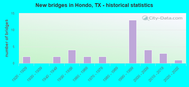
- New bridges - historical statistics
- 21920-1929
- 21940-1949
- 41950-1959
- 21960-1969
- 21970-1979
- 131990-1999
- 42000-2009
- 32010-2019
- 12020-2022
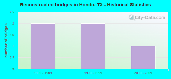
- Reconstructed bridges - Historical Statistics
- 21980-1989
- 21990-1999
- 12000-2009
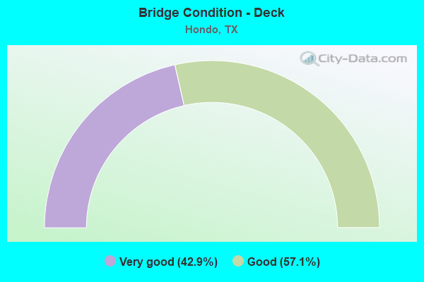
- Bridge Condition - Deck
- 42.9%Very good
- 57.1%Good
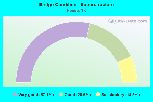
- Bridge Condition - Superstructure
- 57.1%Very good
- 28.6%Good
- 14.3%Satisfactory
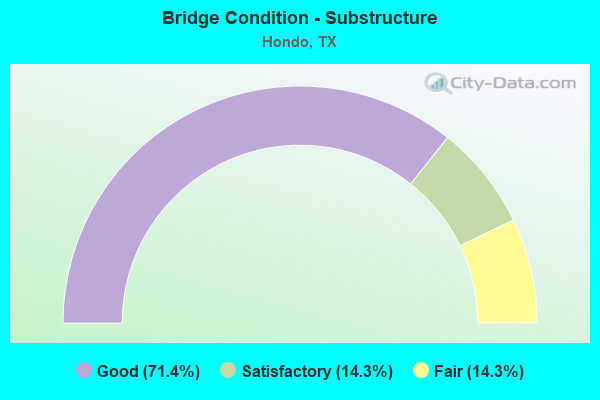
- Bridge Condition - Substructure
- 71.4%Good
- 14.3%Satisfactory
- 14.3%Fair
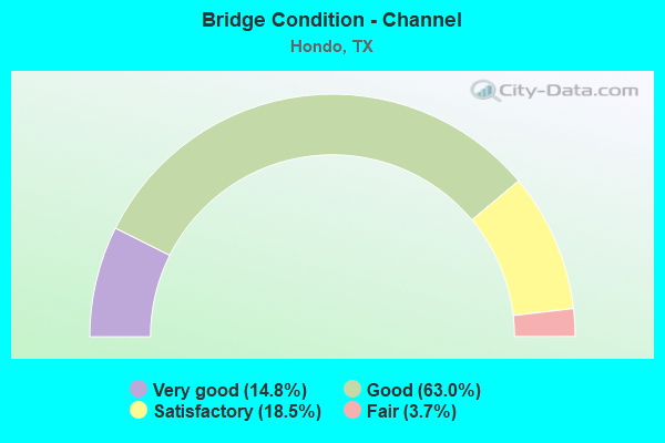
- Bridge Condition - Channel
- 14.8%Very good
- 63.0%Good
- 18.5%Satisfactory
- 3.7%Fair
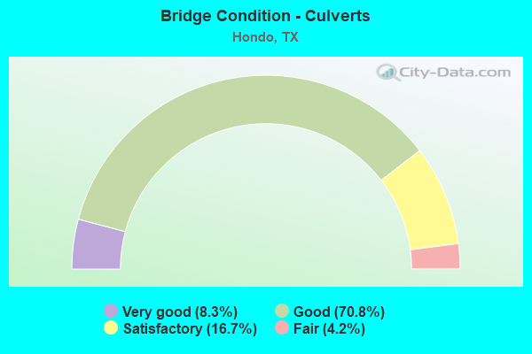
- Bridge Condition - Culverts
- 8.3%Very good
- 70.8%Good
- 16.7%Satisfactory
- 4.2%Fair
Find on map >> Show street view
Structure Number: 1516300024041, Location: 3.1 MI W OF FM 1250 (Lat: 29.336433, Lng: -99.222783), Route carried "on" structure: US 90, Year Built: 1951, Year Reconstructed: 1997, Status: Open, Structure Length: 1.74m (5.71ft), Average Daily Traffic: 8,716 (year 2020), Truck Traffic: 21%, Average Future Daily Traffic: 5,600 (year 2033), Features Intersected: W BRANCH LIVE OAK CREEK
Minimum Vertical Clearance: 30+ m (98+ ft), Kilometerpoint: 20.324, Lanes on structure: 3, Owner: State Highway Agency, Approaching Roadway Width: 13.7m (44.9ft), Material/Design: Concrete, Design/Construction: Culvert, Number Of Spans In Main Unit: 6, Length of Maximum Span: 2.7m (8.9ft), Curb-To-Curb Width: 14.4m (47.2ft), Out-to-Out Width: 15.1m (49.5ft)
Condition: Channel: Good, Culverts: Satisfactory, Operating Rating: 39.9 metric tons, Method Used To Determine Operating Rating: Load Factor (LF), Inventory Rating: 23.6 metric tons, Method Used To Determine Inventory Rating: Load Factor (LF), Structural Evaluation: Somewhat better than minimum adequacy, Deck Geometry: Somewhat better than minimum adequacy, Waterway Adequacy: Equal to present minimum criteria, Approach Roadway Alignment: Equal to present desirable criteria, Designated Inspection Frequency: Every 24 months, Inspection Date: August 2020, Deck Structure Type: Concrete Cast-file-Place, Wearing Surface/Protective System: Wearing Surface: Bituminous
Find on map >> Show street view
Structure Number: 151630002404179, Location: 3.10 MI W OF FM 1250 (Lat: 29.336069, Lng: -99.222803), Route carried "on" structure: US 90, Year Built: 1997, Status: Open, Structure Length: 1.74m (5.71ft), Average Daily Traffic: 4,381 (year 2020), Truck Traffic: 21%, Average Future Daily Traffic: 5,600 (year 2033), Design Load: HS 20, Features Intersected: WEST LIVE OAK CREEK
Minimum Vertical Clearance: 30+ m (98+ ft), Kilometerpoint: 20.324, Lanes on structure: 2, Owner: State Highway Agency, Approaching Roadway Width: 11.6m (38.1ft), Material/Design: Concrete, Design/Construction: Culvert, Number Of Spans In Main Unit: 6, Length of Maximum Span: 2.7m (8.9ft), Curb-To-Curb Width: 13.9m (45.6ft), Out-to-Out Width: 14.6m (47.9ft)
Condition: Channel: Good, Culverts: Good, Operating Rating: 39.9 metric tons, Method Used To Determine Operating Rating: Load Factor (LF), Inventory Rating: 23.6 metric tons, Method Used To Determine Inventory Rating: Load Factor (LF), Structural Evaluation: Equal to present minimum criteria, Deck Geometry: Superior to present desirable criteria, Waterway Adequacy: Equal to present minimum criteria, Approach Roadway Alignment: Equal to present desirable criteria, Designated Inspection Frequency: Every 48 months, Inspection Date: August 2018, Deck Structure Type: Concrete Cast-file-Place, Wearing Surface/Protective System: Wearing Surface: Bituminous
Find on map >> Show street view
Structure Number: 151630002405021, Location: 14.66 MI E OF UVALDE C/L (Lat: 29.337194, Lng: -99.172533), Route carried "on" structure: US 90, Year Built: 2006, Status: Open, Structure Length: 1.10m (3.61ft), Average Daily Traffic: 10,219 (year 2020), Truck Traffic: 11%, Average Future Daily Traffic: 12,830 (year 2033), Design Load: HS 20, Features Intersected: LITTLE LIVE OAK CRK BR.
Minimum Vertical Clearance: 30+ m (98+ ft), Kilometerpoint: 4.165, Lanes on structure: 6, Owner: State Highway Agency, Approaching Roadway Width: 27.4m (89.9ft), Material/Design: Concrete, Design/Construction: Culvert, Number Of Spans In Main Unit: 4, Length of Maximum Span: 2.1m (6.9ft)
Condition: Channel: Good, Culverts: Good, Operating Rating: 44.4 metric tons, Method Used To Determine Operating Rating: Assigned rating based on Load Factor Design (LFD) reported in metric tons, Inventory Rating: 32.7 metric tons, Method Used To Determine Inventory Rating: Assigned rating based on Load Factor Design (LFD) reported in metric tons, Structural Evaluation: Better than present minimum criteria, Waterway Adequacy: Equal to present minimum criteria, Approach Roadway Alignment: Equal to present desirable criteria, Designated Inspection Frequency: Every 48 months, Inspection Date: August 2018
Find on map >> Show street view
Structure Number: 151630002405025, Location: 15.78 MI E OF UVALDE C/L (Lat: 29.345978, Lng: -99.157842), Route carried "on" structure: US 90, Year Built: 1922, Year Reconstructed: 2009, Status: Open, Structure Length: 2.93m (9.61ft), Average Daily Traffic: 9,337 (year 2020), Truck Traffic: 11%, Average Future Daily Traffic: 12,700 (year 2033), Features Intersected: LITTLE LIVE OAK CREEK
Minimum Vertical Clearance: 30+ m (98+ ft), Kilometerpoint: 5.971, Lanes on structure: 5, Owner: State Highway Agency, Approaching Roadway Width: 20.7m (67.9ft), Material/Design: Concrete, Design/Construction: Culvert, Number Of Spans In Main Unit: 9, Length of Maximum Span: 3.0m (9.8ft), Curb or Sidewalk Widths: Left: 0.0m, Right: 2.2m (7.2ft), Curb-To-Curb Width: 21.0m (68.9ft), Out-to-Out Width: 24.4m (80.1ft)
Condition: Channel: Good, Culverts: Satisfactory, Operating Rating: 39.9 metric tons, Method Used To Determine Operating Rating: Load Factor (LF), Inventory Rating: 23.6 metric tons, Method Used To Determine Inventory Rating: Load Factor (LF), Structural Evaluation: Somewhat better than minimum adequacy, Deck Geometry: Somewhat better than minimum adequacy, Waterway Adequacy: Equal to present minimum criteria, Approach Roadway Alignment: Equal to present desirable criteria, Length Of Structure Improvement: 2.93m (9.61ft), Designated Inspection Frequency: Every 24 months, Inspection Date: August 2020, Bridge Improvement Cost: $9,000, Roadway Improvement Cost: $2,000, Total Project Cost: $11,000, Deck Structure Type: Concrete Cast-file-Place, Wearing Surface/Protective System: Wearing Surface: Bituminous
Find on map >> Show street view
Structure Number: 151630002405026, Location: 17.40 MI E OF UVALDE C/L (Lat: 29.348094, Lng: -99.131119), Route carried "on" structure: US 90, Year Built: 1922, Year Reconstructed: 1994, Status: Open, Structure Length: 3.44m (11.29ft), Average Daily Traffic: 19,140 (year 2020), Truck Traffic: 8%, Average Future Daily Traffic: 24,930 (year 2033), Design Load: H 15, Features Intersected: ELM SLOUGH
Minimum Vertical Clearance: 30+ m (98+ ft), Kilometerpoint: 8.578, Lanes on structure: 5, Owner: State Highway Agency, Approaching Roadway Width: 23.8m (78.1ft), Material/Design: Concrete, Design/Construction: Culvert, Number Of Spans In Main Unit: 11, Length of Maximum Span: 3.0m (9.8ft), Curb or Sidewalk Widths: Left: 1.3m (4.3ft), Right: 0.0m, Curb-To-Curb Width: 25.7m (84.3ft), Out-to-Out Width: 27.7m (90.9ft)
Condition: Channel: Good, Culverts: Good, Operating Rating: 39.9 metric tons, Method Used To Determine Operating Rating: Load Factor (LF), Inventory Rating: 23.6 metric tons, Method Used To Determine Inventory Rating: Load Factor (LF), Structural Evaluation: Somewhat better than minimum adequacy, Deck Geometry: Superior to present desirable criteria, Waterway Adequacy: Equal to present minimum criteria, Approach Roadway Alignment: Equal to present desirable criteria, Designated Inspection Frequency: Every 24 months, Inspection Date: August 2020, Deck Structure Type: Concrete Cast-file-Place, Wearing Surface/Protective System: Wearing Surface: Bituminous
Find on map >> Show street view
Structure Number: 151630002405041, Location: US 90 AT SH 173 (Lat: 29.348856, Lng: -99.116922), Route carried "on" structure: State highway 173, Year Built: 1994, Status: Open, Structure Length: 13.87m (45.51ft), Average Daily Traffic: 3,280 (year 2014), Truck Traffic: 12%, Average Future Daily Traffic: 3,500 (year 2034), Design Load: HS 20, Features Intersected: US 90 SP RAILROAD
Minimum Vertical Clearance: 30+ m (98+ ft), Kilometerpoint: 31.997, Lanes on structure: 3, Lanes under structure: 7, Owner: State Highway Agency, Approaching Roadway Width: 13.4m (44.0ft), Material/Design: Prestressed concrete, Design/Construction: Stringer/Multi-beam, Number Of Spans In Main Unit: 2, Number Of Approach Spans: 4, Length of Maximum Span: 33.5m (109.9ft), Curb-To-Curb Width: 13.4m (44.0ft), Out-to-Out Width: 15.9m (52.2ft)
Condition: Deck: Very good, Superstructure: Very good, Substructure: Good, Operating Rating: 54.4 metric tons, Method Used To Determine Operating Rating: Assigned rating based on Load Factor Design (LFD) reported in metric tons, Inventory Rating: 32.7 metric tons, Method Used To Determine Inventory Rating: Assigned rating based on Load Factor Design (LFD) reported in metric tons, Structural Evaluation: Better than present minimum criteria, Deck Geometry: Somewhat better than minimum adequacy, Underclear: Equal to present minimum criteria, Approach Roadway Alignment: Equal to present desirable criteria, Designated Inspection Frequency: Every 24 months, Inspection Date: August 2020, Deck Structure Type: Concrete Cast-file-Place
Find on map >> Show street view
Structure Number: 151630002405042, Location: US 90 AT SH 173 (Lat: 29.349028, Lng: -99.117450), Route carried "on" structure: Ramp US 90, Year Built: 1994, Status: Open, Structure Length: 14.30m (46.92ft), Average Daily Traffic: 17,900 (year 2011), Truck Traffic: 7%, Average Future Daily Traffic: 25,060 (year 2031), Design Load: HS 20, Features Intersected: R.O.W. NORTH OF US 90
Minimum Vertical Clearance: 30+ m (98+ ft), Kilometerpoint: 9.769, Lanes on structure: 1, Owner: State Highway Agency, Approaching Roadway Width: 7.6m (24.9ft), Material/Design: Prestressed concrete, Design/Construction: Stringer/Multi-beam, Number Of Spans In Main Unit: 7, Length of Maximum Span: 22.9m (75.1ft), Curb-To-Curb Width: 7.7m (25.3ft), Out-to-Out Width: 8.5m (27.9ft)
Condition: Deck: Good, Superstructure: Very good, Substructure: Good, Operating Rating: 54.4 metric tons, Method Used To Determine Operating Rating: Assigned rating based on Load Factor Design (LFD) reported in metric tons, Inventory Rating: 32.7 metric tons, Method Used To Determine Inventory Rating: Assigned rating based on Load Factor Design (LFD) reported in metric tons, Structural Evaluation: Better than present minimum criteria, Deck Geometry: Better than present minimum criteria, Approach Roadway Alignment: Equal to present desirable criteria, Designated Inspection Frequency: Every 24 months, Inspection Date: August 2020, Deck Structure Type: Concrete Cast-file-Place
Find on map >> Show street view
Structure Number: 151630002405043, Location: US 90 AT SH 173 (Lat: 29.349094, Lng: -99.116475), Route carried "on" structure: Ramp US 90, Year Built: 1994, Status: Open, Structure Length: 16.00m (52.49ft), Average Daily Traffic: 13,312 (year 2020), Truck Traffic: 7%, Average Future Daily Traffic: 25,060 (year 2031), Design Load: HS 20, Features Intersected: R.O.W. NORTH OF US 90
Minimum Vertical Clearance: 30+ m (98+ ft), Kilometerpoint: 9.960, Lanes on structure: 1, Owner: State Highway Agency, Approaching Roadway Width: 7.6m (24.9ft), Material/Design: Prestressed concrete, Design/Construction: Stringer/Multi-beam, Number Of Spans In Main Unit: 7, Length of Maximum Span: 22.9m (75.1ft), Curb-To-Curb Width: 7.7m (25.3ft), Out-to-Out Width: 8.5m (27.9ft)
Condition: Deck: Good, Superstructure: Very good, Substructure: Good, Operating Rating: 54.4 metric tons, Method Used To Determine Operating Rating: Assigned rating based on Load Factor Design (LFD) reported in metric tons, Inventory Rating: 32.7 metric tons, Method Used To Determine Inventory Rating: Assigned rating based on Load Factor Design (LFD) reported in metric tons, Structural Evaluation: Better than present minimum criteria, Deck Geometry: Better than present minimum criteria, Approach Roadway Alignment: Equal to present desirable criteria, Designated Inspection Frequency: Every 24 months, Inspection Date: August 2020, Deck Structure Type: Concrete Cast-file-Place
Find on map >> Show street view
Structure Number: 151630002405044, Location: US 90 AT SH 173 (Lat: 29.348847, Lng: -99.117036), Route carried "on" structure: State highway 173, Year Built: 1994, Status: Open, Structure Length: 13.87m (45.51ft), Average Daily Traffic: 3,280 (year 2014), Truck Traffic: 12%, Average Future Daily Traffic: 3,500 (year 2034), Design Load: HS 20, Features Intersected: US 90 SP RAILROAD
Minimum Vertical Clearance: 30+ m (98+ ft), Kilometerpoint: 31.997, Lanes on structure: 3, Lanes under structure: 7, Owner: State Highway Agency, Approaching Roadway Width: 13.4m (44.0ft), Material/Design: Prestressed concrete, Design/Construction: Stringer/Multi-beam, Number Of Spans In Main Unit: 2, Number Of Approach Spans: 4, Length of Maximum Span: 33.5m (109.9ft), Curb-To-Curb Width: 13.3m (43.6ft), Out-to-Out Width: 15.9m (52.2ft)
Condition: Deck: Very good, Superstructure: Very good, Substructure: Good, Operating Rating: 54.4 metric tons, Method Used To Determine Operating Rating: Assigned rating based on Load Factor Design (LFD) reported in metric tons, Inventory Rating: 32.7 metric tons, Method Used To Determine Inventory Rating: Assigned rating based on Load Factor Design (LFD) reported in metric tons, Structural Evaluation: Better than present minimum criteria, Deck Geometry: Somewhat better than minimum adequacy, Underclear: Equal to present minimum criteria, Approach Roadway Alignment: Equal to present desirable criteria, Designated Inspection Frequency: Every 24 months, Inspection Date: August 2020, Deck Structure Type: Concrete Cast-file-Place
Find on map >> Show street view
Structure Number: 151630002405095, Location: 19.09 MI E OF UVALDE C/L (Lat: 29.349558, Lng: -99.103278), Route carried "on" structure: US 90, Year Built: 1949, Year Reconstructed: 1987, Status: Open, Structure Length: 1.98m (6.50ft), Average Daily Traffic: 13,312 (year 2020), Truck Traffic: 12%, Average Future Daily Traffic: 17,620 (year 2033), Design Load: H 15, Features Intersected: DRAW
Minimum Vertical Clearance: 30+ m (98+ ft), Kilometerpoint: 11.294, Lanes on structure: 5, Owner: State Highway Agency, Approaching Roadway Width: 23.2m (76.1ft), Skew: 9 degrees, Material/Design: Concrete, Design/Construction: Culvert, Number Of Spans In Main Unit: 6, Length of Maximum Span: 3.0m (9.8ft), Curb-To-Curb Width: 25.9m (85.0ft), Out-to-Out Width: 48.3m (158.5ft)
Condition: Channel: Good, Culverts: Good, Operating Rating: 39.9 metric tons, Method Used To Determine Operating Rating: Load Factor (LF), Inventory Rating: 23.6 metric tons, Method Used To Determine Inventory Rating: Load Factor (LF), Structural Evaluation: Somewhat better than minimum adequacy, Deck Geometry: Superior to present desirable criteria, Waterway Adequacy: Equal to present minimum criteria, Approach Roadway Alignment: Equal to present desirable criteria, Length Of Structure Improvement: 1.98m (6.50ft), Designated Inspection Frequency: Every 24 months, Inspection Date: August 2020, Bridge Improvement Cost: $6,000, Roadway Improvement Cost: $2,000, Total Project Cost: $8,000, Deck Structure Type: Concrete Cast-file-Place, Wearing Surface/Protective System: Wearing Surface: Bituminous
Find on map >> Show street view
Structure Number: 151630002405101, Location: 13.28 MI FROM UVALDE C/L (Lat: 29.336669, Lng: -99.195031), Route carried "on" structure: US 90, Year Built: 1951, Status: Open, Structure Length: 3.93m (12.89ft), Average Daily Traffic: 10,219 (year 2020), Truck Traffic: 11%, Average Future Daily Traffic: 6,410 (year 2033), Features Intersected: EAST LIVE OAK CREEK
Minimum Vertical Clearance: 30+ m (98+ ft), Kilometerpoint: 1.952, Lanes on structure: 2, Owner: State Highway Agency, Approaching Roadway Width: 12.2m (40.0ft), Material/Design: Concrete, Design/Construction: Culvert, Number Of Spans In Main Unit: 12, Length of Maximum Span: 3.0m (9.8ft), Curb-To-Curb Width: 12.0m (39.4ft), Out-to-Out Width: 12.7m (41.7ft)
Condition: Channel: Good, Culverts: Satisfactory, Operating Rating: 39.9 metric tons, Method Used To Determine Operating Rating: Load Factor (LF), Inventory Rating: 23.6 metric tons, Method Used To Determine Inventory Rating: Load Factor (LF), Structural Evaluation: Somewhat better than minimum adequacy, Deck Geometry: Better than present minimum criteria, Waterway Adequacy: Equal to present minimum criteria, Approach Roadway Alignment: Equal to present desirable criteria, Designated Inspection Frequency: Every 24 months, Inspection Date: August 2020, Deck Structure Type: Concrete Cast-file-Place, Wearing Surface/Protective System: Wearing Surface: Bituminous
Find on map >> Show street view
Structure Number: 151630002405178, Location: 13.28 MI FROM UVALDE C/L (Lat: 29.336294, Lng: -99.195458), Route carried "on" structure: US 90, Year Built: 1997, Status: Open, Structure Length: 3.90m (12.80ft), Average Daily Traffic: 5,110 (year 2020), Truck Traffic: 11%, Average Future Daily Traffic: 6,410 (year 2033), Design Load: HS 20, Features Intersected: EAST LIVE OAK CREEK
Minimum Vertical Clearance: 30+ m (98+ ft), Kilometerpoint: 1.952, Lanes on structure: 2, Owner: State Highway Agency, Approaching Roadway Width: 14.0m (45.9ft), Material/Design: Concrete, Design/Construction: Culvert, Number Of Spans In Main Unit: 12, Length of Maximum Span: 3.0m (9.8ft), Curb-To-Curb Width: 13.9m (45.6ft), Out-to-Out Width: 14.6m (47.9ft)
Condition: Channel: Good, Culverts: Satisfactory, Operating Rating: 39.9 metric tons, Method Used To Determine Operating Rating: Load Factor (LF), Inventory Rating: 23.6 metric tons, Method Used To Determine Inventory Rating: Load Factor (LF), Structural Evaluation: Somewhat better than minimum adequacy, Deck Geometry: Superior to present desirable criteria, Waterway Adequacy: Equal to present minimum criteria, Approach Roadway Alignment: Equal to present desirable criteria, Designated Inspection Frequency: Every 48 months, Inspection Date: August 2018, Deck Structure Type: Concrete Cast-file-Place, Wearing Surface/Protective System: Wearing Surface: Bituminous
Find on map >> Show street view
Structure Number: 151630042108023, Location: 1.90 MI N OF US 90 (Lat: 29.376864, Lng: -99.116744), Route carried "on" structure: State highway 173, Year Built: 1957, Status: Open, Structure Length: 15.73m (51.61ft), Average Daily Traffic: 3,600 (year 2020), Truck Traffic: 10%, Average Future Daily Traffic: 3,900 (year 2033), Design Load: HS 20, Features Intersected: HONDO CREEK
Minimum Vertical Clearance: 30+ m (98+ ft), Kilometerpoint: 29.964, Lanes on structure: 2, Owner: State Highway Agency, Approaching Roadway Width: 8.5m (27.9ft), Material/Design: Concrete, Design/Construction: Stringer/Multi-beam, Number Of Spans In Main Unit: 17, Length of Maximum Span: 9.1m (29.9ft), Curb-To-Curb Width: 8.4m (27.6ft), Out-to-Out Width: 9.4m (30.8ft)
Condition: Deck: Good, Superstructure: Satisfactory, Substructure: Satisfactory, Channel: Satisfactory, Operating Rating: 68.0 metric tons, Method Used To Determine Operating Rating: Load Factor (LF), Inventory Rating: 40.8 metric tons, Method Used To Determine Inventory Rating: Load Factor (LF), Structural Evaluation: Equal to present minimum criteria, Deck Geometry: High priority of corrective action, Waterway Adequacy: Equal to present minimum criteria, Approach Roadway Alignment: Equal to present desirable criteria, Length Of Structure Improvement: 15.73m (51.61ft), Designated Inspection Frequency: Every 24 months, Inspection Date: August 2020, Bridge Improvement Cost: $966,000, Roadway Improvement Cost: $97,000, Total Project Cost: $1,449,000, Deck Structure Type: Concrete Cast-file-Place, Wearing Surface/Protective System: Wearing Surface: Bituminous
Find on map >> Show street view
Structure Number: 151630042108024, Location: 20.57 MI FROM BANDERA C L (Lat: 29.358769, Lng: -99.116636), Route carried "on" structure: State highway 173, Year Built: 1957, Status: Open, Structure Length: 1.01m (3.31ft), Average Daily Traffic: 5,848 (year 2020), Truck Traffic: 8%, Average Future Daily Traffic: 6,670 (year 2033), Features Intersected: DRY CREEK
Minimum Vertical Clearance: 30+ m (98+ ft), Kilometerpoint: 32.040, Lanes on structure: 2, Owner: State Highway Agency, Approaching Roadway Width: 9.1m (29.9ft), Material/Design: Concrete, Design/Construction: Culvert, Number Of Spans In Main Unit: 5, Length of Maximum Span: 1.8m (5.9ft), Curb-To-Curb Width: 9.1m (29.9ft), Out-to-Out Width: 13.8m (45.3ft)
Condition: Channel: Good, Culverts: Good, Operating Rating: 39.9 metric tons, Method Used To Determine Operating Rating: Load Factor (LF), Inventory Rating: 23.6 metric tons, Method Used To Determine Inventory Rating: Load Factor (LF), Structural Evaluation: Somewhat better than minimum adequacy, Deck Geometry: High priority of corrective action, Waterway Adequacy: Equal to present minimum criteria, Approach Roadway Alignment: Equal to present desirable criteria, Designated Inspection Frequency: Every 24 months, Inspection Date: August 2020, Deck Structure Type: Concrete Cast-file-Place, Wearing Surface/Protective System: Wearing Surface: Bituminous
Find on map >> Show street view
Structure Number: 15163004210804, Location: 17.38 MI FROM BANDERA C.L (Lat: 29.406306, Lng: -99.116864), Route carried "on" structure: State highway 173, Year Built: 1972, Status: Open, Structure Length: 9.75m (31.99ft), Average Daily Traffic: 2,740 (year 2020), Truck Traffic: 12%, Average Future Daily Traffic: 2,690 (year 2033), Design Load: HS 20, Features Intersected: VERDE CREEK
Minimum Vertical Clearance: 30+ m (98+ ft), Kilometerpoint: 26.905, Lanes on structure: 2, Owner: State Highway Agency, Approaching Roadway Width: 10.4m (34.1ft), Material/Design: Prestressed concrete, Design/Construction: Stringer/Multi-beam, Number Of Spans In Main Unit: 4, Length of Maximum Span: 24.4m (80.1ft), Curb-To-Curb Width: 10.4m (34.1ft), Out-to-Out Width: 11.1m (36.4ft)
Condition: Deck: Very good, Superstructure: Good, Substructure: Good, Channel: Satisfactory, Operating Rating: 54.4 metric tons, Method Used To Determine Operating Rating: Assigned rating based on Load Factor Design (LFD) reported in metric tons, Inventory Rating: 32.7 metric tons, Method Used To Determine Inventory Rating: Assigned rating based on Load Factor Design (LFD) reported in metric tons, Structural Evaluation: Better than present minimum criteria, Deck Geometry: Somewhat better than minimum adequacy, Waterway Adequacy: Equal to present minimum criteria, Approach Roadway Alignment: Equal to present desirable criteria, Designated Inspection Frequency: Every 24 months, Inspection Date: August 2020, Deck Structure Type: Concrete Cast-file-Place, Wearing Surface/Protective System: Wearing Surface: Bituminous
Find on map >> Show street view
Structure Number: 15163008480101, Location: 2.7 Mi. S. of US 90 (Lat: 29.307783, Lng: -99.133253), Route carried "on" structure: State highway 462, Year Built: 2017, Status: Open, Structure Length: 1.10m (3.61ft), Average Daily Traffic: 1,700 (year 2017), Truck Traffic: 1%, Average Future Daily Traffic: 2,400 (year 2039), Design Load: HL 93, Features Intersected: Little Live Oak Creek, Facility Carried by Structure: FM 532
Minimum Vertical Clearance: 30+ m (98+ ft), Kilometerpoint: 4.361, Lanes on structure: 2, Owner: State Highway Agency, Approaching Roadway Width: 6.1m (20.0ft), Material/Design: Concrete, Design/Construction: Culvert, Number Of Spans In Main Unit: 5, Length of Maximum Span: 1.8m (5.9ft), Curb-To-Curb Width: 7.2m (23.6ft), Out-to-Out Width: 7.9m (25.9ft)
Condition: Channel: Satisfactory, Culverts: Good, Operating Rating: 54.4 metric tons, Method Used To Determine Operating Rating: Assigned ratings based on Load and Resistance Factor Design (LRFD) reported in metric tons, Inventory Rating: 32.7 metric tons, Method Used To Determine Inventory Rating: Assigned ratings based on Load and Resistance Factor Design (LRFD) reported in metric tons, Structural Evaluation: Better than present minimum criteria, Deck Geometry: High priority of corrective action, Waterway Adequacy: Equal to present minimum criteria, Approach Roadway Alignment: Equal to present desirable criteria, Designated Inspection Frequency: Every 24 months, Inspection Date: August 2020, Wearing Surface/Protective System: Wearing Surface: Bituminous
Find on map >> Show street view
Structure Number: 151630084801219, Location: 1.9 MI S OF US 90 (Lat: 29.320481, Lng: -99.133419), Route carried "on" structure: State highway 462, Year Built: 2010, Status: Open, Structure Length: 2.04m (6.69ft), Average Daily Traffic: 1,908 (year 2020), Truck Traffic: 10%, Average Future Daily Traffic: 1,870 (year 2032), Design Load: HS 20, Features Intersected: LITTLE LIVE OAK CREEK
Minimum Vertical Clearance: 30+ m (98+ ft), Kilometerpoint: 3.058, Lanes on structure: 2, Owner: State Highway Agency, Approaching Roadway Width: 9.1m (29.9ft), Skew: 3 degrees, Material/Design: Concrete, Design/Construction: Culvert, Number Of Spans In Main Unit: 6, Length of Maximum Span: 2.4m (7.9ft), Curb-To-Curb Width: 12.2m (40.0ft), Out-to-Out Width: 17.5m (57.4ft)
Condition: Channel: Good, Culverts: Good, Operating Rating: 44.4 metric tons, Method Used To Determine Operating Rating: No rating analysis performed, Inventory Rating: 32.7 metric tons, Method Used To Determine Inventory Rating: No rating analysis performed, Structural Evaluation: Better than present minimum criteria, Deck Geometry: Better than present minimum criteria, Waterway Adequacy: Equal to present minimum criteria, Approach Roadway Alignment: Equal to present desirable criteria, Designated Inspection Frequency: Every 48 months, Inspection Date: August 2018, Deck Structure Type: Concrete Cast-file-Place, Wearing Surface/Protective System: Wearing Surface: Bituminous
Find on map >> Show street view
Structure Number: 151630084801221, Location: 2.7 MI S OF US 90 (Lat: 29.307897, Lng: -99.133386), Route carried "on" structure: State highway 462, Year Built: 2010, Status: Open, Structure Length: 1.07m (3.51ft), Average Daily Traffic: 1,908 (year 2020), Truck Traffic: 10%, Average Future Daily Traffic: 2,500 (year 2032), Design Load: HS 20, Features Intersected: LITTLE LIVE OAK CREEK
Minimum Vertical Clearance: 30+ m (98+ ft), Kilometerpoint: 4.345, Lanes on structure: 2, Owner: State Highway Agency, Approaching Roadway Width: 9.1m (29.9ft), Skew: 4 degrees, Material/Design: Concrete, Design/Construction: Culvert, Number Of Spans In Main Unit: 3, Length of Maximum Span: 2.1m (6.9ft), Curb-To-Curb Width: 12.2m (40.0ft), Out-to-Out Width: 17.1m (56.1ft)
Condition: Channel: Very good, Culverts: Very good, Operating Rating: 44.4 metric tons, Method Used To Determine Operating Rating: No rating analysis performed, Inventory Rating: 32.7 metric tons, Method Used To Determine Inventory Rating: No rating analysis performed, Structural Evaluation: Equal to present desirable criteria, Deck Geometry: Better than present minimum criteria, Waterway Adequacy: Equal to present minimum criteria, Approach Roadway Alignment: Equal to present desirable criteria, Designated Inspection Frequency: Every 48 months, Inspection Date: August 2018, Deck Structure Type: Concrete Cast-file-Place, Wearing Surface/Protective System: Wearing Surface: Bituminous
Find on map >> Show street view
Structure Number: 151630084804026, Location: 23.11 MI FROM BANDERA C L (Lat: 29.356700, Lng: -99.142006), Route carried "on" structure: State highway 462, Year Built: 1962, Status: Open, Structure Length: 1.19m (3.90ft), Average Daily Traffic: 2,685 (year 2020), Truck Traffic: 8%, Average Future Daily Traffic: 2,530 (year 2033), Design Load: HS 20, Features Intersected: DRAW
Minimum Vertical Clearance: 30+ m (98+ ft), Kilometerpoint: 37.194, Lanes on structure: 2, Owner: State Highway Agency, Approaching Roadway Width: 12.5m (41.0ft), Material/Design: Concrete, Design/Construction: Culvert, Number Of Spans In Main Unit: 7, Length of Maximum Span: 1.5m (4.9ft), Curb or Sidewalk Widths: Left: 0.9m (3.0ft), Right: 0.9m (3.0ft), Curb-To-Curb Width: 13.4m (44.0ft), Out-to-Out Width: 15.5m (50.9ft)
Condition: Channel: Satisfactory, Culverts: Good, Operating Rating: 39.9 metric tons, Method Used To Determine Operating Rating: Load Factor (LF), Inventory Rating: 23.6 metric tons, Method Used To Determine Inventory Rating: Load Factor (LF), Structural Evaluation: Equal to present minimum criteria, Deck Geometry: Better than present minimum criteria, Waterway Adequacy: Somewhat better than minimum adequacy, Approach Roadway Alignment: Equal to present desirable criteria, Designated Inspection Frequency: Every 24 months, Inspection Date: August 2020, Deck Structure Type: Concrete Cast-file-Place, Wearing Surface/Protective System: Wearing Surface: Bituminous
Find on map >> Show street view
Structure Number: 151630084804223, Location: 26.4 MI FROM BANDERA C L (Lat: 29.381361, Lng: -99.170981), Route carried "on" structure: State highway 462, Year Built: 2020, Status: Open, Structure Length: 1.87m (6.14ft), Average Daily Traffic: 2,394 (year 2019), Truck Traffic: 8%, Average Future Daily Traffic: 1,000 (year 2032), Design Load: HL 93, Features Intersected: Elm Slough
Minimum Vertical Clearance: 30+ m (98+ ft), Kilometerpoint: 42.504, Lanes on structure: 2, Owner: State Highway Agency, Approaching Roadway Width: 9.4m (30.8ft), Material/Design: Concrete, Design/Construction: Culvert, Number Of Spans In Main Unit: 7, Length of Maximum Span: 2.1m (6.9ft), Curb-To-Curb Width: 10.8m (35.4ft), Out-to-Out Width: 11.6m (38.1ft)
Condition: Channel: Very good, Culverts: Very good, Operating Rating: 54.4 metric tons, Method Used To Determine Operating Rating: Assigned ratings based on Load and Resistance Factor Design (LRFD) reported in metric tons, Inventory Rating: 32.7 metric tons, Method Used To Determine Inventory Rating: Assigned ratings based on Load and Resistance Factor Design (LRFD) reported in metric tons, Structural Evaluation: Equal to present desirable criteria, Deck Geometry: Somewhat better than minimum adequacy, Waterway Adequacy: Equal to present minimum criteria, Approach Roadway Alignment: Equal to present desirable criteria, Designated Inspection Frequency: Every 24 months, Inspection Date: May 2021, Deck Structure Type: Concrete Cast-file-Place, Wearing Surface/Protective System: Wearing Surface: Bituminous
Find on map >> Show street view
Structure Number: 151630084804227, Location: 25.11 MI FROM BANDERA C L (Lat: 29.374000, Lng: -99.156589), Route carried "on" structure: State highway 462, Year Built: 1992, Status: Open, Structure Length: 1.87m (6.14ft), Average Daily Traffic: 2,394 (year 2019), Truck Traffic: 8%, Average Future Daily Traffic: 1,000 (year 2032), Design Load: HS 20, Features Intersected: Elm Slough
Minimum Vertical Clearance: 30+ m (98+ ft), Kilometerpoint: 40.412, Lanes on structure: 2, Owner: State Highway Agency, Approaching Roadway Width: 8.8m (28.9ft), Skew: 3 degrees, Material/Design: Concrete, Design/Construction: Culvert, Number Of Spans In Main Unit: 7, Length of Maximum Span: 2.5m (8.2ft), Curb-To-Curb Width: 9.0m (29.5ft), Out-to-Out Width: 9.8m (32.2ft)
Condition: Channel: Good, Culverts: Good, Operating Rating: 39.9 metric tons, Method Used To Determine Operating Rating: Load Factor (LF), Inventory Rating: 23.6 metric tons, Method Used To Determine Inventory Rating: Load Factor (LF), Structural Evaluation: Equal to present minimum criteria, Deck Geometry: Meets minimum limits, Waterway Adequacy: Equal to present minimum criteria, Approach Roadway Alignment: Equal to present desirable criteria, Designated Inspection Frequency: Every 24 months, Inspection Date: June 2021, Deck Structure Type: Concrete Cast-file-Place, Wearing Surface/Protective System: Wearing Surface: Bituminous
Find on map >> Show street view
Structure Number: 151630084804228, Location: 25.0 MI FROM BANDERA C L (Lat: 29.374039, Lng: -99.154111), Route carried "on" structure: State highway 462, Year Built: 1992, Status: Open, Structure Length: 1.91m (6.27ft), Average Daily Traffic: 2,394 (year 2019), Truck Traffic: 8%, Average Future Daily Traffic: 1,000 (year 2032), Design Load: HS 20, Features Intersected: Elm Slough
Minimum Vertical Clearance: 30+ m (98+ ft), Kilometerpoint: 40.234, Lanes on structure: 2, Owner: State Highway Agency, Approaching Roadway Width: 8.8m (28.9ft), Skew: 1 degrees, Material/Design: Concrete, Design/Construction: Culvert, Number Of Spans In Main Unit: 8, Length of Maximum Span: 2.2m (7.2ft), Curb-To-Curb Width: 9.0m (29.5ft), Out-to-Out Width: 9.8m (32.2ft)
Condition: Channel: Very good, Culverts: Good, Operating Rating: 39.9 metric tons, Method Used To Determine Operating Rating: Load Factor (LF), Inventory Rating: 23.6 metric tons, Method Used To Determine Inventory Rating: Load Factor (LF), Structural Evaluation: Equal to present minimum criteria, Deck Geometry: Meets minimum limits, Waterway Adequacy: Equal to present minimum criteria, Approach Roadway Alignment: Equal to present desirable criteria, Designated Inspection Frequency: Every 24 months, Inspection Date: June 2021, Deck Structure Type: Concrete Cast-file-Place, Wearing Surface/Protective System: Wearing Surface: Bituminous
Find on map >> Show street view
Structure Number: 151630084804229, Location: 23.51 MI FROM BANDERA C L (Lat: 29.362489, Lng: -99.142000), Route carried "on" structure: State highway 462, Year Built: 1992, Status: Open, Structure Length: 1.96m (6.43ft), Average Daily Traffic: 2,394 (year 2019), Truck Traffic: 8%, Average Future Daily Traffic: 1,000 (year 2032), Design Load: HS 20, Features Intersected: Elm Slough
Minimum Vertical Clearance: 30+ m (98+ ft), Kilometerpoint: 37.837, Lanes on structure: 2, Owner: State Highway Agency, Approaching Roadway Width: 8.8m (28.9ft), Skew: 4 degrees, Material/Design: Concrete, Design/Construction: Culvert, Number Of Spans In Main Unit: 6, Length of Maximum Span: 3.0m (9.8ft), Curb-To-Curb Width: 9.0m (29.5ft), Out-to-Out Width: 9.8m (32.2ft)
Condition: Channel: Good, Culverts: Good, Operating Rating: 39.9 metric tons, Method Used To Determine Operating Rating: Load Factor (LF), Inventory Rating: 23.6 metric tons, Method Used To Determine Inventory Rating: Load Factor (LF), Structural Evaluation: Equal to present minimum criteria, Deck Geometry: Meets minimum limits, Waterway Adequacy: Equal to present minimum criteria, Approach Roadway Alignment: Equal to present desirable criteria, Designated Inspection Frequency: Every 24 months, Inspection Date: June 2021, Deck Structure Type: Concrete Cast-file-Place, Wearing Surface/Protective System: Wearing Surface: Bituminous
Find on map >> Show street view
Structure Number: 151630264901002, Location: 1.53 MI E of SH 173 (Lat: 29.374333, Lng: -99.092733), Route carried "on" structure: State highway 2676, Year Built: 1970, Status: Open, Structure Length: 15.85m (52.00ft), Average Daily Traffic: 2,097 (year 2020), Truck Traffic: 12%, Average Future Daily Traffic: 2,130 (year 2033), Design Load: H 15, Features Intersected: HONDO CREEK
Minimum Vertical Clearance: 30+ m (98+ ft), Kilometerpoint: 4.083, Lanes on structure: 2, Owner: State Highway Agency, Approaching Roadway Width: 8.5m (27.9ft), Material/Design: Concrete, Design/Construction: Stringer/Multi-beam, Number Of Spans In Main Unit: 13, Length of Maximum Span: 12.2m (40.0ft), Curb-To-Curb Width: 7.8m (25.6ft), Out-to-Out Width: 8.6m (28.2ft)
Condition: Deck: Good, Superstructure: Good, Substructure: Fair, Channel: Fair, Operating Rating: 59.9 metric tons, Method Used To Determine Operating Rating: Load Factor (LF), Inventory Rating: 35.4 metric tons, Method Used To Determine Inventory Rating: Load Factor (LF), Structural Evaluation: Somewhat better than minimum adequacy, Deck Geometry: High priority of replacement, Waterway Adequacy: Equal to present minimum criteria, Approach Roadway Alignment: Equal to present desirable criteria, Designated Inspection Frequency: Every 24 months, Inspection Date: August 2020, Deck Structure Type: Concrete Cast-file-Place, Wearing Surface/Protective System: Wearing Surface: Bituminous
Find on map >> Show street view
Structure Number: 151630264901012, Location: 2.3 MI NE OF SH 173 (Lat: 29.380436, Lng: -99.080064), Route carried "on" structure: State highway 2676, Year Built: 2001, Status: Open, Structure Length: 1.83m (6.00ft), Average Daily Traffic: 2,097 (year 2020), Average Future Daily Traffic: 1,370 (year 2030), Design Load: HS 20, Features Intersected: NO NAME CREEK
Minimum Vertical Clearance: 30+ m (98+ ft), Kilometerpoint: 3.701, Lanes on structure: 2, Owner: State Highway Agency, Approaching Roadway Width: 8.5m (27.9ft), Material/Design: Concrete, Design/Construction: Culvert, Number Of Spans In Main Unit: 8, Length of Maximum Span: 2.1m (6.9ft), Curb-To-Curb Width: 10.8m (35.4ft), Out-to-Out Width: 10.8m (35.4ft)
Condition: Channel: Good, Culverts: Good, Operating Rating: 44.4 metric tons, Method Used To Determine Operating Rating: No rating analysis performed, Inventory Rating: 32.7 metric tons, Method Used To Determine Inventory Rating: No rating analysis performed, Structural Evaluation: Better than present minimum criteria, Deck Geometry: Somewhat better than minimum adequacy, Waterway Adequacy: Equal to present minimum criteria, Approach Roadway Alignment: Equal to present desirable criteria, Designated Inspection Frequency: Every 48 months, Inspection Date: August 2018, Deck Structure Type: Concrete Cast-file-Place, Wearing Surface/Protective System: Wearing Surface: Bituminous
Find on map >> Show street view
Structure Number: 151630312701001, Location: 1.42 MI FROM US 90 (Lat: 29.336781, Lng: -99.148586), Route carried "on" structure: State highway 1250, Year Built: 1969, Status: Open, Structure Length: 1.31m (4.30ft), Average Daily Traffic: 2,219 (year 2020), Truck Traffic: 8%, Average Future Daily Traffic: 3,060 (year 2033), Features Intersected: LITTLE LIVE OAK CREEK
Minimum Vertical Clearance: 30+ m (98+ ft), Kilometerpoint: 2.285, Lanes on structure: 2, Owner: State Highway Agency, Approaching Roadway Width: 7.3m (24.0ft), Material/Design: Concrete, Design/Construction: Culvert, Number Of Spans In Main Unit: 5, Length of Maximum Span: 2.4m (7.9ft), Curb-To-Curb Width: 11.0m (36.1ft), Out-to-Out Width: 11.4m (37.4ft)
Condition: Channel: Good, Culverts: Good, Operating Rating: 39.9 metric tons, Method Used To Determine Operating Rating: Load Factor (LF), Inventory Rating: 23.6 metric tons, Method Used To Determine Inventory Rating: Load Factor (LF), Structural Evaluation: Equal to present minimum criteria, Deck Geometry: Somewhat better than minimum adequacy, Waterway Adequacy: Equal to present minimum criteria, Approach Roadway Alignment: Equal to present desirable criteria, Designated Inspection Frequency: Every 24 months, Inspection Date: August 2020, Deck Structure Type: Concrete Cast-file-Place, Wearing Surface/Protective System: Wearing Surface: Bituminous
Find on map >> Show street view
Structure Number: 151630AA0300006, Location: 0.05 MI S OF FM 462 (Lat: 29.372758, Lng: -99.159619), Route carried "on" structure: County highway , Year Built: 1990, Status: Open, Structure Length: 1.62m (5.31ft), Average Daily Traffic: 869 (year 2020), Average Future Daily Traffic: 3,000 (year 2035), Design Load: HS 20, Features Intersected: DRAW, Facility Carried by Structure: CASTRO AVE
Minimum Vertical Clearance: 30+ m (98+ ft), Kilometerpoint: 0.080, Lanes on structure: 2, Owner: County Highway Agency, Approaching Roadway Width: 9.8m (32.2ft), Material/Design: Concrete, Design/Construction: Culvert, Number Of Spans In Main Unit: 7, Length of Maximum Span: 2.1m (6.9ft), Curb-To-Curb Width: 9.6m (31.5ft), Out-to-Out Width: 10.4m (34.1ft)
Condition: Channel: Good, Culverts: Good, Operating Rating: 39.9 metric tons, Method Used To Determine Operating Rating: Load Factor (LF), Inventory Rating: 23.6 metric tons, Method Used To Determine Inventory Rating: Load Factor (LF), Structural Evaluation: Equal to present minimum criteria, Deck Geometry: Equal to present minimum criteria, Waterway Adequacy: Equal to present minimum criteria, Approach Roadway Alignment: Equal to present desirable criteria, Designated Inspection Frequency: Every 24 months, Inspection Date: May 2021, Deck Structure Type: Concrete Cast-file-Place, Wearing Surface/Protective System: Wearing Surface: Bituminous
Find on map >> Show street view
Structure Number: 151630AA0300007, Location: 0.02 MI N OF US 90 (Lat: 29.346197, Lng: -99.159578), Route carried "on" structure: County highway , Year Built: 1940, Status: Open, Structure Length: 0.70m (2.30ft), Average Daily Traffic: 1,828 (year 2020), Average Future Daily Traffic: 3,000 (year 2035), Features Intersected: DRAW, Facility Carried by Structure: CASTRO AVE
Minimum Vertical Clearance: 30+ m (98+ ft), Kilometerpoint: 1.609, Lanes on structure: 2, Owner: County Highway Agency, Approaching Roadway Width: 9.1m (29.9ft), Material/Design: Concrete, Design/Construction: Culvert, Number Of Spans In Main Unit: 4, Length of Maximum Span: 1.5m (4.9ft), Curb-To-Curb Width: 18.9m (62.0ft), Out-to-Out Width: 19.9m (65.3ft)
Condition: Channel: Satisfactory, Culverts: Fair, Operating Rating: 32.7 metric tons, Method Used To Determine Operating Rating: Field evaluation and documented engineering judgment, Inventory Rating: 24.5 metric tons, Method Used To Determine Inventory Rating: Field evaluation and documented engineering judgment, Structural Evaluation: Somewhat better than minimum adequacy, Deck Geometry: Superior to present desirable criteria, Waterway Adequacy: Equal to present minimum criteria, Approach Roadway Alignment: Equal to present desirable criteria, Designated Inspection Frequency: Every 24 months, Inspection Date: May 2021, Deck Structure Type: Concrete Cast-file-Place, Wearing Surface/Protective System: Wearing Surface: Bituminous
Find on map >> Show street view
Structure Number: 151630D00155001, Location: 0.8 MI W OF SH 173 (Lat: 29.348603, Lng: -99.131489), Route carried "on" structure: City street , Year Built: 1995, Year Reconstructed: 2002, Status: Open, Structure Length: 3.41m (11.19ft), Average Daily Traffic: 1,871 (year 2020), Average Future Daily Traffic: 3,400 (year 2035), Design Load: HS 20, Features Intersected: ELM SLOUGH, Facility Carried by Structure: 18TH ST
Minimum Vertical Clearance: 30+ m (98+ ft), Kilometerpoint: 1.287, Lanes on structure: 2, Owner: City or Municipal Highway Agency, Approaching Roadway Width: 7.3m (24.0ft), Material/Design: Concrete, Design/Construction: Culvert, Number Of Spans In Main Unit: 13, Length of Maximum Span: 2.4m (7.9ft), Curb or Sidewalk Widths: Left: 1.3m (4.3ft), Right: 0.0m, Curb-To-Curb Width: 7.2m (23.6ft), Out-to-Out Width: 9.4m (30.8ft)
Condition: Channel: Good, Culverts: Good, Operating Rating: 39.9 metric tons, Method Used To Determine Operating Rating: Load Factor (LF), Inventory Rating: 23.6 metric tons, Method Used To Determine Inventory Rating: Load Factor (LF), Structural Evaluation: Equal to present minimum criteria, Deck Geometry: High priority of corrective action, Waterway Adequacy: Better than present minimum criteria, Approach Roadway Alignment: Equal to present desirable criteria, Designated Inspection Frequency: Every 24 months, Inspection Date: May 2021, Bridge Improvement Cost: $175,000, Roadway Improvement Cost: $17,000, Total Project Cost: $262,000, Deck Structure Type: Concrete Cast-file-Place, Wearing Surface/Protective System: Wearing Surface: Bituminous
Find on map >> Show street view
Structure Number: 151630D00270001, Location: 0.15 MI N OF FM 1250 (Lat: 29.339117, Lng: -99.150306), Route carried "on" structure: City street , Year Built: 2006, Status: Open, Structure Length: 1.83m (6.00ft), Average Daily Traffic: 1,845 (year 2020), Truck Traffic: 10%, Average Future Daily Traffic: 3,900 (year 2035), Design Load: HS 20, Features Intersected: LITTLE LIVE OAK CREEK, Facility Carried by Structure: AVENUE U
Minimum Vertical Clearance: 30+ m (98+ ft), Kilometerpoint: 0.805, Lanes on structure: 3, Owner: City or Municipal Highway Agency, Approaching Roadway Width: 11.0m (36.1ft), Skew: 4 degrees, Material/Design: Concrete, Design/Construction: Culvert, Number Of Spans In Main Unit: 5, Length of Maximum Span: 2.1m (6.9ft), Curb-To-Curb Width: 11.0m (36.1ft), Out-to-Out Width: 19.3m (63.3ft)
Condition: Channel: Good, Culverts: Good, Operating Rating: 54.4 metric tons, Method Used To Determine Operating Rating: Assigned rating based on Load Factor Design (LFD) reported in metric tons, Inventory Rating: 32.7 metric tons, Method Used To Determine Inventory Rating: Assigned rating based on Load Factor Design (LFD) reported in metric tons, Structural Evaluation: Better than present minimum criteria, Deck Geometry: High priority of replacement, Waterway Adequacy: Better than present minimum criteria, Approach Roadway Alignment: Equal to present desirable criteria, Length Of Structure Improvement: 1.83m (6.00ft), Designated Inspection Frequency: Every 24 months, Inspection Date: May 2021, Bridge Improvement Cost: $4,000, Roadway Improvement Cost: $1,000, Total Project Cost: $5,000, Deck Structure Type: Concrete Cast-file-Place, Wearing Surface/Protective System: Wearing Surface: Bituminous
Find on map >> Show street view
Structure Number: 151630D00270002, Location: 0.05 MI N OF FM 1250 (Lat: 29.337764, Lng: -99.150336), Route carried "on" structure: City street , Year Built: 2006, Status: Open, Structure Length: 0.79m (2.59ft), Average Daily Traffic: 1,845 (year 2020), Truck Traffic: 10%, Average Future Daily Traffic: 3,900 (year 2035), Design Load: HS 20, Features Intersected: LITTLE LIVE OAK BRANCH, Facility Carried by Structure: AVENUE U
Minimum Vertical Clearance: 30+ m (98+ ft), Kilometerpoint: 0.966, Lanes on structure: 3, Owner: City or Municipal Highway Agency, Approaching Roadway Width: 11.0m (36.1ft), Material/Design: Concrete, Design/Construction: Culvert, Number Of Spans In Main Unit: 4, Length of Maximum Span: 1.5m (4.9ft), Curb-To-Curb Width: 11.1m (36.4ft), Out-to-Out Width: 15.6m (51.2ft)
Condition: Channel: Very good, Culverts: Good, Operating Rating: 54.4 metric tons, Method Used To Determine Operating Rating: Assigned rating based on Load Factor Design (LFD) reported in metric tons, Inventory Rating: 32.7 metric tons, Method Used To Determine Inventory Rating: Assigned rating based on Load Factor Design (LFD) reported in metric tons, Structural Evaluation: Better than present minimum criteria, Deck Geometry: High priority of replacement, Waterway Adequacy: Better than present minimum criteria, Approach Roadway Alignment: Equal to present desirable criteria, Length Of Structure Improvement: 0.70m (2.30ft), Designated Inspection Frequency: Every 24 months, Inspection Date: May 2021, Bridge Improvement Cost: $2,000, Roadway Improvement Cost: $1,000, Total Project Cost: $3,000, Deck Structure Type: Concrete Cast-file-Place, Wearing Surface/Protective System: Wearing Surface: Bituminous
Find on map >> Show street view
Structure Number: 151630002405041, Location: US 90 AT SH 173 (Lat: 29.348856, Lng: -99.116922), Route carried "under" structure: US 90, Year Built: 1994, Structure Length: 0. m, Average Daily Traffic: 17,800 (year 2013), Truck Traffic: 8%, Features Intersected: US 90 SP RAILROAD, Facility Carried by Structure: SH 173 NB
Minimum Vertical Clearance: 8.23m (27.00ft), Kilometerpoint: 10.004, Lanes on structure: 3, Lanes under structure: 7, Material/Design: Prestressed concrete, Design/Construction: Stringer/Multi-beam, Length of Maximum Span: 33.5m (109.9ft)
Find on map >> Show street view
Structure Number: 151630002405044, Location: US 90 AT SH 173 (Lat: 29.348847, Lng: -99.117036), Route carried "under" structure: US 90, Year Built: 1994, Structure Length: 0. m, Average Daily Traffic: 17,800 (year 2013), Truck Traffic: 8%, Features Intersected: US 90 SP RAILROAD, Facility Carried by Structure: SH 173 SB
Minimum Vertical Clearance: 8.08m (26.51ft), Kilometerpoint: 10.007, Lanes on structure: 3, Lanes under structure: 7, Material/Design: Prestressed concrete, Design/Construction: Stringer/Multi-beam, Length of Maximum Span: 33.5m (109.9ft)