Bridge Statistics for Hopedale, Illinois (IL)
Condition, Traffic, Stress, Structural Evaluation, Project Costs
- National Bridge Inventory (NBI) Statistics
- 30Number of bridges
- 443ft / 135mTotal length
- $1,325,000Total costs
- 79,595Total average daily traffic
- 16,152Total average daily truck traffic
- National Bridge Inventory (NBI) Registered Bridges for Hopedale
- No street view available for this location
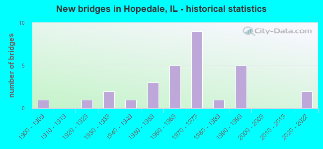
- New bridges - historical statistics
- 11900-1909
- 11920-1929
- 21930-1939
- 11940-1949
- 31950-1959
- 51960-1969
- 91970-1979
- 11980-1989
- 51990-1999
- 22020-2022

- Reconstructed bridges - Historical Statistics
- 11960-1969
- 01970-1979
- 01980-1989
- 11990-1999


- Bridge Condition - Deck
- 5.0%Excellent
- 35.0%Good
- 10.0%Satisfactory
- 20.0%Fair
- 25.0%Poor
- 5.0%Serious

- Bridge Condition - Superstructure
- 5.0%Excellent
- 30.0%Good
- 10.0%Satisfactory
- 25.0%Fair
- 15.0%Poor
- 10.0%Serious
- 5.0%Critical

- Bridge Condition - Substructure
- 5.0%Excellent
- 10.0%Very good
- 15.0%Good
- 25.0%Satisfactory
- 45.0%Fair

- Bridge Condition - Channel
- 31.8%Good
- 50.0%Satisfactory
- 13.6%Fair
- 4.5%Poor

- Bridge Condition - Culverts
- 16.7%Excellent
- 83.3%Satisfactory
Find on map >> Show street view
Structure Number: 900087, Location: 1mi N HOPEDALE JCT (Lat: 40.440383, Lng: -89.468458), Route carried "on" structure: County highway , Year Built: 1932, Year Reconstructed: 1971, Status: Open, Structure Length: 20.45m (67.09ft), Average Daily Traffic: 125 (year 2018), Truck Traffic: 3%, Average Future Daily Traffic: 81 (year 2032), Design Load: HS 25 or greater, Features Intersected: MACKINAW RIVER, Facility Carried by Structure: OLD ILL 121
Minimum Vertical Clearance: 4.50m (14.76ft), Kilometerpoint: 5.166, Lanes on structure: 2, Owner: State Highway Agency, Approaching Roadway Width: 7.3m (24.0ft), Material/Design: Steel, Design/Construction: Truss - Thru, Number Of Spans In Main Unit: 1, Number Of Approach Spans: 9, Length of Maximum Span: 53.3m (174.9ft), Curb-To-Curb Width: 7.3m (24.0ft), Out-to-Out Width: 7.3m (24.0ft)
Condition: Deck: Serious, Superstructure: Serious, Substructure: Fair, Channel: Good, Operating Rating: 45.0 metric tons, Method Used To Determine Operating Rating: Load Factor (LF) rating reported by rating factor (RF) method using MS18 loading, Inventory Rating: 24.3 metric tons, Method Used To Determine Inventory Rating: Load Factor (LF) rating reported by rating factor (RF) method using MS18 loading, Structural Evaluation: High priority of corrective action, Deck Geometry: Somewhat better than minimum adequacy, Waterway Adequacy: Equal to present minimum criteria, Approach Roadway Alignment: Equal to present minimum criteria, Length Of Structure Improvement: 18.32m (60.10ft), Designated Inspection Frequency: Every 12 months, Critical Feature Inspection Frequency: Every 12 months, Underwater Inspection Frequency: Every 12 months, Other Special Inspection Frequency: Every 6 months, Inspection Date: June 2021, Critical Feature Inspection Date: April 2021, Underwater Inspection Date: July 2021, Other Special Inspection Date: June 2021, Bridge Improvement Cost: $883,000, Roadway Improvement Cost: $88,000, Total Project Cost: $1,325,000, Deck Structure Type: Concrete Cast-file-Place
Find on map >> Show street view
Structure Number: 900092, Location: 1mi N JCT I-155 /122 (Lat: 40.439194, Lng: -89.466650), Route carried "on" structure: Interstate 155, Year Built: 1970, Status: Open, Structure Length: 16.76m (54.99ft), Average Daily Traffic: 6,400 (year 2021), Truck Traffic: 21%, Average Future Daily Traffic: 6,773 (year 2032), Design Load: HS 20, Features Intersected: MACKINAW RIVER
Minimum Vertical Clearance: 30+ m (98+ ft), Kilometerpoint: 31.237, Lanes on structure: 2, Base Highway Network: Yes, Owner: State Highway Agency, Approaching Roadway Width: 12.8m (42.0ft), Skew: 2 degrees, Material/Design: Steel continuous, Design/Construction: Stringer/Multi-beam, Number Of Spans In Main Unit: 6, Length of Maximum Span: 42.7m (140.1ft), Curb-To-Curb Width: 13.0m (42.7ft), Out-to-Out Width: 14.0m (45.9ft)
Condition: Deck: Poor, Superstructure: Poor, Substructure: Fair, Channel: Fair, Operating Rating: 63.2 metric tons, Method Used To Determine Operating Rating: Load Factor (LF) rating reported by rating factor (RF) method using MS18 loading, Inventory Rating: 33.0 metric tons, Method Used To Determine Inventory Rating: Load Factor (LF) rating reported by rating factor (RF) method using MS18 loading, Structural Evaluation: Meets minimum limits, Deck Geometry: Superior to present desirable criteria, Waterway Adequacy: Equal to present desirable criteria, Approach Roadway Alignment: Equal to present desirable criteria, Designated Inspection Frequency: Every 12 months, Underwater Inspection Frequency: Every 12 months, Inspection Date: March 2021, Underwater Inspection Date: July 2021, Deck Structure Type: Concrete Cast-file-Place, Wearing Surface/Protective System: Wearing Surface: Other, Deck Protection: Cathodic Protection
Find on map >> Show street view
Structure Number: 900093, Location: .5 MI S 155&122 INT (Lat: 40.420219, Lng: -89.456708), Route carried "on" structure: Interstate 155, Year Built: 1971, Status: Open, Structure Length: 5.43m (17.81ft), Average Daily Traffic: 5,550 (year 2021), Truck Traffic: 22%, Average Future Daily Traffic: 5,913 (year 2032), Design Load: HS 20, Features Intersected: INDIAN CREEK
Minimum Vertical Clearance: 30+ m (98+ ft), Kilometerpoint: 28.935, Lanes on structure: 2, Base Highway Network: Yes, Owner: State Highway Agency, Approaching Roadway Width: 13.4m (44.0ft), Material/Design: Prestressed concrete continuous, Design/Construction: Stringer/Multi-beam, Number Of Spans In Main Unit: 3, Length of Maximum Span: 17.7m (58.1ft), Curb-To-Curb Width: 12.3m (40.4ft), Out-to-Out Width: 13.4m (44.0ft)
Condition: Deck: Poor, Superstructure: Fair, Substructure: Fair, Channel: Fair, Operating Rating: 76.1 metric tons, Method Used To Determine Operating Rating: Load Factor (LF) rating reported by rating factor (RF) method using MS18 loading, Inventory Rating: 47.0 metric tons, Method Used To Determine Inventory Rating: Load Factor (LF) rating reported by rating factor (RF) method using MS18 loading, Structural Evaluation: Somewhat better than minimum adequacy, Deck Geometry: Better than present minimum criteria, Waterway Adequacy: Superior to present desirable criteria, Approach Roadway Alignment: Equal to present desirable criteria, Designated Inspection Frequency: Every 24 months, Other Special Inspection Frequency: Every 12 months, Inspection Date: May 2021, Other Special Inspection Date: May 2021, Deck Structure Type: Concrete Cast-file-Place, Wearing Surface/Protective System: Wearing Surface: Other, Deck Protection: Cathodic Protection
Find on map >> Show street view
Structure Number: 900094, Location: .5 MI S 121&122 INT (Lat: 40.420075, Lng: -89.456706), Route carried "on" structure: Interstate 155, Year Built: 1971, Status: Open, Structure Length: 5.43m (17.81ft), Average Daily Traffic: 5,550 (year 2021), Truck Traffic: 22%, Average Future Daily Traffic: 5,913 (year 2032), Design Load: HS 20, Features Intersected: INDIAN CR
Minimum Vertical Clearance: 30+ m (98+ ft), Kilometerpoint: 28.919, Lanes on structure: 2, Base Highway Network: Yes, Owner: State Highway Agency, Approaching Roadway Width: 13.4m (44.0ft), Material/Design: Prestressed concrete continuous, Design/Construction: Stringer/Multi-beam, Number Of Spans In Main Unit: 3, Length of Maximum Span: 17.7m (58.1ft), Curb-To-Curb Width: 12.3m (40.4ft), Out-to-Out Width: 13.4m (44.0ft)
Condition: Deck: Poor, Superstructure: Critical, Substructure: Fair, Channel: Satisfactory, Operating Rating: 53.8 metric tons, Method Used To Determine Operating Rating: Load Factor (LF) rating reported by rating factor (RF) method using MS18 loading, Inventory Rating: 32.1 metric tons, Method Used To Determine Inventory Rating: Load Factor (LF) rating reported by rating factor (RF) method using MS18 loading, Structural Evaluation: High priority of replacement, Deck Geometry: Better than present minimum criteria, Waterway Adequacy: Superior to present desirable criteria, Approach Roadway Alignment: Equal to present desirable criteria, Designated Inspection Frequency: Every 12 months, Other Special Inspection Frequency: Every 6 months, Inspection Date: May 2021, Other Special Inspection Date: July 2021, Deck Structure Type: Concrete Cast-file-Place, Wearing Surface/Protective System: Wearing Surface: Other, Deck Protection: Cathodic Protection
Find on map >> Show street view
Structure Number: 900095, Location: 2 MI W OF HOPEDALE (Lat: 40.427578, Lng: -89.457725), Route carried "on" structure: County highway , Year Built: 1971, Status: Open, Structure Length: 8.72m (28.61ft), Average Daily Traffic: 1,750 (year 2018), Truck Traffic: 16%, Average Future Daily Traffic: 1,451 (year 2032), Design Load: HS 20, Features Intersected: I-155, Facility Carried by Structure: ILL 122
Minimum Vertical Clearance: 30+ m (98+ ft), Kilometerpoint: 7.177, Lanes on structure: 2, Lanes under structure: 4, Base Highway Network: Yes, Owner: State Highway Agency, Approaching Roadway Width: 14.6m (47.9ft), Skew: 33 degrees, Material/Design: Steel continuous, Design/Construction: Stringer/Multi-beam, Number Of Spans In Main Unit: 2, Number Of Approach Spans: 2, Length of Maximum Span: 32.0m (105.0ft), Curb-To-Curb Width: 19.7m (64.6ft), Out-to-Out Width: 20.7m (67.9ft)
Condition: Deck: Poor, Superstructure: Poor, Substructure: Fair, Operating Rating: 66.7 metric tons, Method Used To Determine Operating Rating: Load Factor (LF) rating reported by rating factor (RF) method using MS18 loading, Inventory Rating: 40.2 metric tons, Method Used To Determine Inventory Rating: Load Factor (LF) rating reported by rating factor (RF) method using MS18 loading, Structural Evaluation: Meets minimum limits, Deck Geometry: Superior to present desirable criteria, Underclear: Equal to present minimum criteria, Approach Roadway Alignment: Equal to present minimum criteria, Designated Inspection Frequency: Every 12 months, Inspection Date: April 2021, Deck Structure Type: Concrete Cast-file-Place, Wearing Surface/Protective System: Wearing Surface: Bituminous
Find on map >> Show street view
Structure Number: 9001, Location: 1mi N JCT I-155 /122 (Lat: 40.439075, Lng: -89.466547), Route carried "on" structure: Interstate 155, Year Built: 1970, Status: Open, Structure Length: 16.76m (54.99ft), Average Daily Traffic: 6,400 (year 2021), Truck Traffic: 21%, Average Future Daily Traffic: 6,773 (year 2032), Design Load: HS 20, Features Intersected: MACKINAW RIVER
Minimum Vertical Clearance: 30+ m (98+ ft), Kilometerpoint: 31.220, Lanes on structure: 2, Base Highway Network: Yes, Owner: State Highway Agency, Approaching Roadway Width: 12.8m (42.0ft), Skew: 2 degrees, Material/Design: Steel continuous, Design/Construction: Stringer/Multi-beam, Number Of Spans In Main Unit: 6, Length of Maximum Span: 42.7m (140.1ft), Curb-To-Curb Width: 11.7m (38.4ft), Out-to-Out Width: 12.8m (42.0ft)
Condition: Deck: Poor, Superstructure: Serious, Substructure: Fair, Channel: Poor, Operating Rating: 65.4 metric tons, Method Used To Determine Operating Rating: Load Factor (LF) rating reported by rating factor (RF) method using MS18 loading, Inventory Rating: 34.3 metric tons, Method Used To Determine Inventory Rating: Load Factor (LF) rating reported by rating factor (RF) method using MS18 loading, Structural Evaluation: High priority of corrective action, Deck Geometry: Equal to present minimum criteria, Waterway Adequacy: Equal to present desirable criteria, Approach Roadway Alignment: Equal to present desirable criteria, Designated Inspection Frequency: Every 12 months, Underwater Inspection Frequency: Every 12 months, Other Special Inspection Frequency: Every 6 months, Inspection Date: March 2021, Underwater Inspection Date: July 2021, Other Special Inspection Date: October 2021, Deck Structure Type: Concrete Cast-file-Place, Wearing Surface/Protective System: Wearing Surface: Other, Deck Protection: Cathodic Protection
Find on map >> Show street view
Structure Number: 900101, Location: 1M S OF HOPEDALE (Lat: 40.409781, Lng: -89.456914), Route carried "on" structure: County highway , Year Built: 1972, Status: Open, Structure Length: 5.76m (18.90ft), Average Daily Traffic: 650 (year 2018), Truck Traffic: 9%, Average Future Daily Traffic: 645 (year 2032), Design Load: HS 15, Features Intersected: I-155, Facility Carried by Structure: TOBOGGAN AVE-FAS 4
Minimum Vertical Clearance: 30+ m (98+ ft), Kilometerpoint: 22.015, Lanes on structure: 2, Lanes under structure: 4, Owner: State Highway Agency, Approaching Roadway Width: 11.6m (38.1ft), Material/Design: Steel continuous, Design/Construction: Stringer/Multi-beam, Number Of Spans In Main Unit: 2, Number Of Approach Spans: 2, Length of Maximum Span: 29.6m (97.1ft), Curb-To-Curb Width: 8.7m (28.5ft), Out-to-Out Width: 9.8m (32.2ft)
Condition: Deck: Fair, Superstructure: Fair, Substructure: Satisfactory, Operating Rating: 76.5 metric tons, Method Used To Determine Operating Rating: Load Factor (LF) rating reported by rating factor (RF) method using MS18 loading, Inventory Rating: 37.3 metric tons, Method Used To Determine Inventory Rating: Load Factor (LF) rating reported by rating factor (RF) method using MS18 loading, Structural Evaluation: Somewhat better than minimum adequacy, Deck Geometry: Somewhat better than minimum adequacy, Underclear: Somewhat better than minimum adequacy, Approach Roadway Alignment: Equal to present minimum criteria, Designated Inspection Frequency: Every 24 months, Inspection Date: December 2020, Deck Structure Type: Concrete Cast-file-Place, Wearing Surface/Protective System: Wearing Surface: Bituminous, Membrane: Built-up
Find on map >> Show street view
Structure Number: 900137, Location: 4.9 MI S OF ILL 9 (Lat: 40.454169, Lng: -89.470181), Route carried "on" structure: County highway , Year Built: 1990, Status: Open, Structure Length: 6.83m (22.41ft), Average Daily Traffic: 100 (year 2018), Truck Traffic: 3%, Average Future Daily Traffic: 81 (year 2032), Design Load: HS 20, Features Intersected: I-155, Facility Carried by Structure: FEATHER RD - FAS 4
Minimum Vertical Clearance: 30+ m (98+ ft), Kilometerpoint: 3.315, Lanes on structure: 2, Lanes under structure: 4, Owner: State Highway Agency, Approaching Roadway Width: 9.1m (29.9ft), Material/Design: Steel continuous, Design/Construction: Stringer/Multi-beam, Number Of Spans In Main Unit: 2, Number Of Approach Spans: 2, Length of Maximum Span: 29.4m (96.5ft), Curb-To-Curb Width: 9.1m (29.9ft), Out-to-Out Width: 10.1m (33.1ft)
Condition: Deck: Satisfactory, Superstructure: Fair, Substructure: Good, Operating Rating: 45.4 metric tons, Method Used To Determine Operating Rating: Load Factor (LF) rating reported by rating factor (RF) method using MS18 loading, Inventory Rating: 27.2 metric tons, Method Used To Determine Inventory Rating: Load Factor (LF) rating reported by rating factor (RF) method using MS18 loading, Structural Evaluation: Somewhat better than minimum adequacy, Deck Geometry: Better than present minimum criteria, Underclear: Somewhat better than minimum adequacy, Approach Roadway Alignment: Equal to present minimum criteria, Designated Inspection Frequency: Every 24 months, Inspection Date: June 2020, Deck Structure Type: Concrete Cast-file-Place, Wearing Surface/Protective System: Deck Protection: Epoxy Coated Reinforcing
Find on map >> Show street view
Structure Number: 900138, Location: S. INTERCHGE IL 122 (Lat: 40.380950, Lng: -89.455692), Route carried "on" structure: State highway 122, Year Built: 1992, Status: Open, Structure Length: 6.54m (21.46ft), Average Daily Traffic: 1,450 (year 2021), Truck Traffic: 12%, Average Future Daily Traffic: 1,559 (year 2032), Design Load: HS 20, Features Intersected: I-155
Minimum Vertical Clearance: 30+ m (98+ ft), Kilometerpoint: 16.077, Lanes on structure: 2, Lanes under structure: 4, Base Highway Network: Yes, Owner: State Highway Agency, Approaching Roadway Width: 18.9m (62.0ft), Skew: 20 degrees, Material/Design: Steel continuous, Design/Construction: Stringer/Multi-beam, Number Of Spans In Main Unit: 2, Number Of Approach Spans: 2, Length of Maximum Span: 27.7m (90.9ft), Curb-To-Curb Width: 19.1m (62.7ft), Out-to-Out Width: 19.8m (65.0ft)
Condition: Deck: Fair, Superstructure: Fair, Substructure: Fair, Operating Rating: 78.4 metric tons, Method Used To Determine Operating Rating: Load Factor (LF) rating reported by rating factor (RF) method using MS18 loading, Inventory Rating: 47.0 metric tons, Method Used To Determine Inventory Rating: Load Factor (LF) rating reported by rating factor (RF) method using MS18 loading, Structural Evaluation: Somewhat better than minimum adequacy, Deck Geometry: Superior to present desirable criteria, Underclear: Somewhat better than minimum adequacy, Approach Roadway Alignment: Equal to present minimum criteria, Designated Inspection Frequency: Every 24 months, Inspection Date: Febuary 2021, Deck Structure Type: Concrete Cast-file-Place, Wearing Surface/Protective System: Deck Protection: Epoxy Coated Reinforcing
Find on map >> Show street view
Structure Number: 90301, Location: N.CTR-3-T23NR3W (Lat: 40.482517, Lng: -89.428994), Route carried "on" structure: County highway , Year Built: 1962, Year Reconstructed: 1996, Status: Open, Structure Length: 14.48m (47.51ft), Average Daily Traffic: 1,350 (year 2018), Truck Traffic: 11%, Average Future Daily Traffic: 1,183 (year 2032), Design Load: HS 20, Features Intersected: MACKINAW RIVER, Facility Carried by Structure: FAS 1481-CH 7
Minimum Vertical Clearance: 30+ m (98+ ft), Kilometerpoint: 9.447, Lanes on structure: 2, Owner: County Highway Agency, Approaching Roadway Width: 8.5m (27.9ft), Material/Design: Steel, Design/Construction: Stringer/Multi-beam, Number Of Spans In Main Unit: 5, Length of Maximum Span: 34.7m (113.8ft), Curb-To-Curb Width: 8.5m (27.9ft), Out-to-Out Width: 8.5m (27.9ft)
Condition: Deck: Satisfactory, Superstructure: Good, Substructure: Fair, Channel: Satisfactory, Operating Rating: 62.2 metric tons, Method Used To Determine Operating Rating: Load Factor (LF) rating reported by rating factor (RF) method using MS18 loading, Inventory Rating: 37.3 metric tons, Method Used To Determine Inventory Rating: Load Factor (LF) rating reported by rating factor (RF) method using MS18 loading, Structural Evaluation: Somewhat better than minimum adequacy, Deck Geometry: Somewhat better than minimum adequacy, Waterway Adequacy: Superior to present desirable criteria, Approach Roadway Alignment: Equal to present desirable criteria, Designated Inspection Frequency: Every 24 months, Inspection Date: January 2021, Deck Structure Type: Concrete Cast-file-Place, Wearing Surface/Protective System: Deck Protection: Epoxy Coated Reinforcing
Find on map >> Show street view
Structure Number: 903024, Location: NE-15-T23NR5W (Lat: 40.451586, Lng: -89.418522), Route carried "on" structure: County highway , Year Built: 1961, Status: Open, Structure Length: 4.45m (14.60ft), Average Daily Traffic: 650 (year 2018), Truck Traffic: 2%, Average Future Daily Traffic: 591 (year 2032), Design Load: HS 15, Features Intersected: LITTLE MACKINAW RV, Facility Carried by Structure: FAS 469-CH 9
Minimum Vertical Clearance: 30+ m (98+ ft), Kilometerpoint: 3.074, Lanes on structure: 2, Owner: County Highway Agency, Approaching Roadway Width: 10.1m (33.1ft), Material/Design: Steel, Design/Construction: Stringer/Multi-beam, Number Of Spans In Main Unit: 3, Length of Maximum Span: 17.4m (57.1ft), Curb-To-Curb Width: 7.9m (25.9ft), Out-to-Out Width: 9.3m (30.5ft)
Condition: Deck: Fair, Superstructure: Poor, Substructure: Good, Channel: Satisfactory, Operating Rating: 39.5 metric tons, Method Used To Determine Operating Rating: Load Factor (LF) rating reported by rating factor (RF) method using MS18 loading, Inventory Rating: 23.7 metric tons, Method Used To Determine Inventory Rating: Load Factor (LF) rating reported by rating factor (RF) method using MS18 loading, Structural Evaluation: Meets minimum limits, Deck Geometry: Somewhat better than minimum adequacy, Waterway Adequacy: Superior to present desirable criteria, Approach Roadway Alignment: Equal to present desirable criteria, Designated Inspection Frequency: Every 24 months, Inspection Date: January 2022, Deck Structure Type: Concrete Cast-file-Place, Wearing Surface/Protective System: Wearing Surface: Bituminous, Membrane: Built-up
Find on map >> Show street view
Structure Number: 903123, Location: E.CTR-24-T23NR4W (Lat: 40.431019, Lng: -89.493969), Route carried "on" structure: County highway , Year Built: 1900, Status: Open, Structure Length: 0.79m (2.59ft), Average Daily Traffic: 125 (year 2018), Truck Traffic: 6%, Average Future Daily Traffic: 161 (year 2032), Features Intersected: STREAM, Facility Carried by Structure: TULLAMORE RD-TR 21
Minimum Vertical Clearance: 30+ m (98+ ft), Kilometerpoint: 4.490, Lanes on structure: 2, Owner: Town or Township Highway Agency, Approaching Roadway Width: 7.3m (24.0ft), Material/Design: Steel, Design/Construction: Stringer/Multi-beam, Number Of Spans In Main Unit: 1, Length of Maximum Span: 7.6m (24.9ft), Curb-To-Curb Width: 6.9m (22.6ft), Out-to-Out Width: 7.2m (23.6ft)
Condition: Deck: Good, Superstructure: Satisfactory, Substructure: Satisfactory, Channel: Satisfactory, Operating Rating: 38.2 metric tons, Method Used To Determine Operating Rating: Allowable Stress (AS) rating reported by rating factor (RF) method using MS18 loading, Inventory Rating: 25.9 metric tons, Method Used To Determine Inventory Rating: Allowable Stress (AS) rating reported by rating factor (RF) method using MS18 loading, Structural Evaluation: Equal to present minimum criteria, Deck Geometry: Meets minimum limits, Waterway Adequacy: Superior to present desirable criteria, Approach Roadway Alignment: Equal to present desirable criteria, Designated Inspection Frequency: Every 24 months, Inspection Date: January 2022, Deck Structure Type: Concrete Cast-file-Place, Wearing Surface/Protective System: Wearing Surface: Bituminous
Find on map >> Show street view
Structure Number: 903124, Location: CTR-19-T23NR3W (Lat: 40.429856, Lng: -89.480992), Route carried "on" structure: County highway , Year Built: 1952, Status: Posted for load, Structure Length: 1.25m (4.10ft), Average Daily Traffic: 175 (year 2018), Truck Traffic: 5%, Average Future Daily Traffic: 188 (year 2032), Features Intersected: INDIAN CREEK, Facility Carried by Structure: TULLAMORE RD-TR 21
Minimum Vertical Clearance: 30+ m (98+ ft), Kilometerpoint: 5.665, Lanes on structure: 2, Owner: Town or Township Highway Agency, Approaching Roadway Width: 7.3m (24.0ft), Material/Design: Steel, Design/Construction: Stringer/Multi-beam, Number Of Spans In Main Unit: 1, Length of Maximum Span: 11.9m (39.0ft), Curb-To-Curb Width: 6.7m (22.0ft), Out-to-Out Width: 7.2m (23.6ft)
Condition: Deck: Good, Superstructure: Satisfactory, Substructure: Satisfactory, Channel: Satisfactory, Operating Rating: 28.8 metric tons, Method Used To Determine Operating Rating: Allowable Stress (AS) rating reported by rating factor (RF) method using MS18 loading, Inventory Rating: 18.1 metric tons, Method Used To Determine Inventory Rating: Allowable Stress (AS) rating reported by rating factor (RF) method using MS18 loading, Structural Evaluation: Somewhat better than minimum adequacy, Deck Geometry: Meets minimum limits, Waterway Adequacy: Better than present minimum criteria, Approach Roadway Alignment: Equal to present minimum criteria, Bridge Posting: Required (Relationship of Operating Rating to Maximum Legal Load: 20.0 - 29.9% below), Designated Inspection Frequency: Every 24 months, Inspection Date: January 2022, Deck Structure Type: Concrete Cast-file-Place
Find on map >> Show street view
Structure Number: 90313, Location: NW-14-T23NR3W (Lat: 40.451811, Lng: -89.416183), Route carried "on" structure: County highway , Year Built: 1934, Status: Open, Structure Length: 2.56m (8.40ft), Average Daily Traffic: 50 (year 2018), Average Future Daily Traffic: 54 (year 2032), Features Intersected: LITTLE MACKINAW RIVE, Facility Carried by Structure: VALLEY RD - TR 240
Minimum Vertical Clearance: 30+ m (98+ ft), Kilometerpoint: 1.175, Lanes on structure: 2, Owner: Town or Township Highway Agency, Approaching Roadway Width: 4.9m (16.1ft), Material/Design: Steel, Design/Construction: Truss - Thru, Number Of Spans In Main Unit: 1, Length of Maximum Span: 24.4m (80.1ft), Curb-To-Curb Width: 6.1m (20.0ft), Out-to-Out Width: 6.4m (21.0ft)
Condition: Deck: Fair, Superstructure: Fair, Substructure: Good, Channel: Satisfactory, Operating Rating: 55.4 metric tons, Method Used To Determine Operating Rating: Allowable Stress (AS) rating reported by rating factor (RF) method using MS18 loading, Inventory Rating: 39.2 metric tons, Method Used To Determine Inventory Rating: Allowable Stress (AS) rating reported by rating factor (RF) method using MS18 loading, Structural Evaluation: Somewhat better than minimum adequacy, Deck Geometry: Somewhat better than minimum adequacy, Waterway Adequacy: Equal to present minimum criteria, Approach Roadway Alignment: Equal to present minimum criteria, Designated Inspection Frequency: Every 24 months, Critical Feature Inspection Frequency: Every 24 months, Inspection Date: January 2021, Critical Feature Inspection Date: July 2021, Deck Structure Type: Concrete Cast-file-Place
Find on map >> Show street view
Structure Number: 903158, Location: SE-4-T23NR3W (Lat: 40.467786, Lng: -89.445231), Route carried "on" structure: County highway , Year Built: 1970, Status: Open, Structure Length: 1.77m (5.81ft), Average Daily Traffic: 50 (year 2018), Average Future Daily Traffic: 54 (year 2032), Design Load: H 15, Features Intersected: PRAIRIE CREEK, Facility Carried by Structure: MT. RD. - TR 171
Minimum Vertical Clearance: 30+ m (98+ ft), Kilometerpoint: 2.607, Lanes on structure: 2, Owner: Town or Township Highway Agency, Approaching Roadway Width: 5.6m (18.4ft), Material/Design: Steel, Design/Construction: Stringer/Multi-beam, Number Of Spans In Main Unit: 1, Length of Maximum Span: 17.7m (58.1ft), Curb-To-Curb Width: 7.9m (25.9ft), Out-to-Out Width: 8.7m (28.5ft)
Condition: Deck: Good, Superstructure: Good, Substructure: Fair, Channel: Satisfactory, Operating Rating: 38.2 metric tons, Method Used To Determine Operating Rating: Allowable Stress (AS) rating reported by rating factor (RF) method using MS18 loading, Inventory Rating: 24.0 metric tons, Method Used To Determine Inventory Rating: Allowable Stress (AS) rating reported by rating factor (RF) method using MS18 loading, Structural Evaluation: Somewhat better than minimum adequacy, Deck Geometry: Equal to present minimum criteria, Waterway Adequacy: Equal to present desirable criteria, Approach Roadway Alignment: Equal to present minimum criteria, Designated Inspection Frequency: Every 24 months, Inspection Date: January 2021, Deck Structure Type: Concrete Cast-file-Place
Find on map >> Show street view
Structure Number: 903162, Location: S.CTR-7-T23NR2W (Lat: 40.459058, Lng: -89.370694), Route carried "on" structure: County highway , Year Built: 1968, Status: Posted for load, Structure Length: 2.83m (9.28ft), Average Daily Traffic: 50 (year 2018), Average Future Daily Traffic: 54 (year 2032), Design Load: H 15, Features Intersected: LITTLE MACKINAW R., Facility Carried by Structure: RAILSBACK RD-TR 27
Minimum Vertical Clearance: 30+ m (98+ ft), Kilometerpoint: 0.354, Lanes on structure: 2, Owner: Town or Township Highway Agency, Approaching Roadway Width: 7.9m (25.9ft), Material/Design: Steel continuous, Design/Construction: Stringer/Multi-beam, Number Of Spans In Main Unit: 2, Length of Maximum Span: 13.7m (44.9ft), Curb-To-Curb Width: 7.3m (24.0ft), Out-to-Out Width: 8.5m (27.9ft)
Condition: Deck: Good, Superstructure: Good, Substructure: Satisfactory, Channel: Satisfactory, Operating Rating: 28.8 metric tons, Method Used To Determine Operating Rating: Load Factor (LF) rating reported by rating factor (RF) method using MS18 loading, Inventory Rating: 17.5 metric tons, Method Used To Determine Inventory Rating: Load Factor (LF) rating reported by rating factor (RF) method using MS18 loading, Structural Evaluation: Somewhat better than minimum adequacy, Deck Geometry: Equal to present minimum criteria, Waterway Adequacy: Better than present minimum criteria, Approach Roadway Alignment: Equal to present desirable criteria, Designated Inspection Frequency: Every 24 months, Inspection Date: January 2022, Deck Structure Type: Concrete Cast-file-Place
Find on map >> Show street view
Structure Number: 903176, Location: SW-16-T23NR3W (Lat: 40.442233, Lng: -89.451975), Route carried "on" structure: County highway , Year Built: 1969, Status: Open, Structure Length: 2.65m (8.69ft), Average Daily Traffic: 75 (year 2018), Average Future Daily Traffic: 81 (year 2032), Design Load: H 15, Features Intersected: LITTLE MACKINAW R., Facility Carried by Structure: WILDLIFE DR - TR 2
Minimum Vertical Clearance: 30+ m (98+ ft), Kilometerpoint: 1.931, Lanes on structure: 2, Owner: Town or Township Highway Agency, Approaching Roadway Width: 7.9m (25.9ft), Material/Design: Steel continuous, Design/Construction: Stringer/Multi-beam, Number Of Spans In Main Unit: 2, Length of Maximum Span: 12.8m (42.0ft), Curb-To-Curb Width: 7.9m (25.9ft), Out-to-Out Width: 8.6m (28.2ft)
Condition: Deck: Good, Superstructure: Good, Substructure: Satisfactory, Channel: Fair, Operating Rating: 36.9 metric tons, Method Used To Determine Operating Rating: Allowable Stress (AS) rating reported by rating factor (RF) method using MS18 loading, Inventory Rating: 25.3 metric tons, Method Used To Determine Inventory Rating: Allowable Stress (AS) rating reported by rating factor (RF) method using MS18 loading, Structural Evaluation: Equal to present minimum criteria, Deck Geometry: Equal to present minimum criteria, Waterway Adequacy: Equal to present minimum criteria, Approach Roadway Alignment: Equal to present desirable criteria, Designated Inspection Frequency: Every 24 months, Inspection Date: January 2022, Deck Structure Type: Concrete Cast-file-Place
Find on map >> Show street view
Structure Number: 903204, Location: E. CTR-12-T23NR3W (Lat: 40.461936, Lng: -89.382861), Route carried "on" structure: County highway , Year Built: 1987, Status: Open, Structure Length: 2.16m (7.09ft), Average Daily Traffic: 75 (year 2018), Average Future Daily Traffic: 81 (year 2032), Design Load: HS 20, Features Intersected: SARGENT SLOUGH, Facility Carried by Structure: TR 187
Minimum Vertical Clearance: 30+ m (98+ ft), Kilometerpoint: 6.131, Lanes on structure: 2, Owner: Town or Township Highway Agency, Approaching Roadway Width: 7.3m (24.0ft), Skew: 3 degrees, Material/Design: Prestressed concrete, Design/Construction: Box Beam or Girders - Multiple, Number Of Spans In Main Unit: 1, Length of Maximum Span: 20.7m (67.9ft), Curb-To-Curb Width: 8.6m (28.2ft), Out-to-Out Width: 8.6m (28.2ft)
Condition: Deck: Good, Superstructure: Good, Substructure: Very good, Channel: Good, Operating Rating: 44.4 metric tons, Method Used To Determine Operating Rating: Assigned rating based on Load Factor Design (LFD) reported by rating factor (RF) using MS18 loading, Inventory Rating: 32.4 metric tons, Method Used To Determine Inventory Rating: Assigned rating based on Load Factor Design (LFD) reported by rating factor (RF) using MS18 loading, Structural Evaluation: Better than present minimum criteria, Deck Geometry: Better than present minimum criteria, Waterway Adequacy: Better than present minimum criteria, Approach Roadway Alignment: Equal to present minimum criteria, Designated Inspection Frequency: Every 48 months, Inspection Date: January 2020, Deck Structure Type: Concrete Precast Panels
Find on map >> Show street view
Structure Number: 903221, Location: NE-33-T23NR3W (Lat: 40.404728, Lng: -89.438844), Route carried "on" structure: County highway , Year Built: 1996, Status: Open, Structure Length: 2.44m (8.01ft), Average Daily Traffic: 25 (year 2018), Average Future Daily Traffic: 27 (year 2032), Design Load: HS 20, Features Intersected: STREAM, Facility Carried by Structure: TR 255
Minimum Vertical Clearance: 30+ m (98+ ft), Kilometerpoint: 0.789, Lanes on structure: 2, Owner: Town or Township Highway Agency, Approaching Roadway Width: 6.1m (20.0ft), Material/Design: Prestressed concrete, Design/Construction: Box Beam or Girders - Multiple, Number Of Spans In Main Unit: 1, Length of Maximum Span: 24.0m (78.7ft), Curb-To-Curb Width: 7.3m (24.0ft), Out-to-Out Width: 7.3m (24.0ft)
Condition: Deck: Good, Superstructure: Good, Substructure: Very good, Channel: Good, Operating Rating: 44.1 metric tons, Method Used To Determine Operating Rating: Assigned rating based on Load Factor Design (LFD) reported by rating factor (RF) using MS18 loading, Inventory Rating: 32.4 metric tons, Method Used To Determine Inventory Rating: Assigned rating based on Load Factor Design (LFD) reported by rating factor (RF) using MS18 loading, Structural Evaluation: Better than present minimum criteria, Deck Geometry: Equal to present minimum criteria, Waterway Adequacy: Equal to present desirable criteria, Approach Roadway Alignment: Equal to present desirable criteria, Designated Inspection Frequency: Every 48 months, Inspection Date: January 2020, Deck Structure Type: Concrete Precast Panels
Find on map >> Show street view
Structure Number: 903253, Location: 0.5 MI S JCT IL 122 (Lat: 40.420611, Lng: -89.455217), Route carried "on" structure: County highway , Year Built: 2021, Status: Open, Structure Length: 2.37m (7.78ft), Average Daily Traffic: 275 (year 2018), Truck Traffic: 12%, Average Future Daily Traffic: 275 (year 2028), Design Load: HS 25 or greater, Features Intersected: INDIAN CR, Facility Carried by Structure: SBI 122 (Prairie R
Minimum Vertical Clearance: 30+ m (98+ ft), Kilometerpoint: 0.595, Lanes on structure: 2, Owner: Town or Township Highway Agency, Approaching Roadway Width: 6.1m (20.0ft), Skew: 1 degrees, Material/Design: Prestressed concrete, Design/Construction: Box Beam or Girders - Multiple, Number Of Spans In Main Unit: 1, Length of Maximum Span: 0.0m, Curb-To-Curb Width: 8.5m (27.9ft), Out-to-Out Width: 8.5m (27.9ft)
Condition: Deck: Excellent, Superstructure: Excellent, Substructure: Excellent, Channel: Good, Operating Rating: 54.4 metric tons, Method Used To Determine Operating Rating: Load and Resistance Factor Rating (LRFR) rating reported by rating factor(RF) method using HL-93 loadings, Inventory Rating: 42.4 metric tons, Method Used To Determine Inventory Rating: Load and Resistance Factor Rating (LRFR) rating reported by rating factor(RF) method using HL-93 loadings, Structural Evaluation: Superior to present desirable criteria, Deck Geometry: Equal to present minimum criteria, Waterway Adequacy: Better than present minimum criteria, Approach Roadway Alignment: Better than present minimum criteria, Designated Inspection Frequency: Every 24 months, Inspection Date: September 2021, Deck Structure Type: Concrete Precast Panels
Find on map >> Show street view
Structure Number: 90503, Location: SE-12-T22NR3W (Lat: 40.373711, Lng: -89.378781), Route carried "on" structure: County highway , Year Built: 1955, Status: Open, Structure Length: 0.79m (2.59ft), Average Daily Traffic: 75 (year 2018), Average Future Daily Traffic: 81 (year 2032), Features Intersected: STREAM, Facility Carried by Structure: TR 260
Minimum Vertical Clearance: 30+ m (98+ ft), Kilometerpoint: 5.745, Lanes on structure: 2, Owner: Town or Township Highway Agency, Approaching Roadway Width: 4.7m (15.4ft), Material/Design: Concrete, Design/Construction: Culvert, Number Of Spans In Main Unit: 2, Length of Maximum Span: 3.7m (12.1ft)
Condition: Channel: Good, Culverts: Satisfactory, Operating Rating: 38.6 metric tons, Method Used To Determine Operating Rating: Allowable Stress (AS) rating reported by rating factor (RF) method using MS18 loading, Inventory Rating: 23.0 metric tons, Method Used To Determine Inventory Rating: Allowable Stress (AS) rating reported by rating factor (RF) method using MS18 loading, Structural Evaluation: Equal to present minimum criteria, Waterway Adequacy: Superior to present desirable criteria, Approach Roadway Alignment: Equal to present desirable criteria, Designated Inspection Frequency: Every 24 months, Inspection Date: January 2021, Wearing Surface/Protective System: Wearing Surface: Bituminous
Find on map >> Show street view
Structure Number: 905032, Location: SW-1-T22NR3W (Lat: 40.387936, Lng: -89.398261), Route carried "on" structure: County highway , Year Built: 1968, Status: Open, Structure Length: 0.91m (2.99ft), Average Daily Traffic: 500 (year 2018), Truck Traffic: 5%, Average Future Daily Traffic: 591 (year 2032), Features Intersected: STREAM, Facility Carried by Structure: FAS 469-CH 9
Minimum Vertical Clearance: 30+ m (98+ ft), Kilometerpoint: 11.346, Lanes on structure: 2, Owner: County Highway Agency, Approaching Roadway Width: 8.7m (28.5ft), Skew: 2 degrees, Material/Design: Concrete, Design/Construction: Culvert, Number Of Spans In Main Unit: 3, Length of Maximum Span: 3.0m (9.8ft)
Condition: Channel: Satisfactory, Culverts: Satisfactory, Operating Rating: 20.4 metric tons, Method Used To Determine Operating Rating: Load Factor (LF) rating reported by rating factor (RF) method using MS18 loading, Inventory Rating: 12.3 metric tons, Method Used To Determine Inventory Rating: Load Factor (LF) rating reported by rating factor (RF) method using MS18 loading, Structural Evaluation: Meets minimum limits, Waterway Adequacy: Superior to present desirable criteria, Approach Roadway Alignment: Equal to present desirable criteria, Designated Inspection Frequency: Every 24 months, Inspection Date: January 2021
Find on map >> Show street view
Structure Number: 905043, Location: NE COR-4-T22NR3W (Lat: 40.395614, Lng: -89.437553), Route carried "on" structure: County highway , Year Built: 1948, Status: Open, Structure Length: 0.67m (2.20ft), Average Daily Traffic: 10 (year 2018), Average Future Daily Traffic: 11 (year 2032), Features Intersected: STREAM, Facility Carried by Structure: TR 253A
Minimum Vertical Clearance: 30+ m (98+ ft), Kilometerpoint: 1.513, Lanes on structure: 2, Owner: Town or Township Highway Agency, Approaching Roadway Width: 6.7m (22.0ft), Material/Design: Concrete, Design/Construction: Culvert, Number Of Spans In Main Unit: 2, Length of Maximum Span: 3.0m (9.8ft)
Condition: Channel: Satisfactory, Culverts: Satisfactory, Operating Rating: 40.5 metric tons, Method Used To Determine Operating Rating: Field evaluation and documented engineering judgment, Inventory Rating: 24.3 metric tons, Method Used To Determine Inventory Rating: Field evaluation and documented engineering judgment, Structural Evaluation: Equal to present minimum criteria, Waterway Adequacy: Better than present minimum criteria, Approach Roadway Alignment: Equal to present desirable criteria, Designated Inspection Frequency: Every 24 months, Inspection Date: January 2022, Wearing Surface/Protective System: Wearing Surface: Gravel
Find on map >> Show street view
Structure Number: 905045, Location: SE-1-T22NR3W (Lat: 40.382181, Lng: -89.387214), Route carried "on" structure: County highway , Year Built: 1950, Status: Open, Structure Length: 0.79m (2.59ft), Average Daily Traffic: 75 (year 2018), Average Future Daily Traffic: 81 (year 2032), Features Intersected: STREAM, Facility Carried by Structure: TR 257
Minimum Vertical Clearance: 30+ m (98+ ft), Kilometerpoint: 5.745, Lanes on structure: 2, Owner: Town or Township Highway Agency, Approaching Roadway Width: 6.1m (20.0ft), Skew: 3 degrees, Material/Design: Concrete, Design/Construction: Culvert, Number Of Spans In Main Unit: 2, Length of Maximum Span: 3.7m (12.1ft)
Condition: Channel: Good, Culverts: Satisfactory, Operating Rating: 40.5 metric tons, Method Used To Determine Operating Rating: Field evaluation and documented engineering judgment, Inventory Rating: 24.3 metric tons, Method Used To Determine Inventory Rating: Field evaluation and documented engineering judgment, Structural Evaluation: Equal to present minimum criteria, Waterway Adequacy: Better than present minimum criteria, Approach Roadway Alignment: Equal to present desirable criteria, Designated Inspection Frequency: Every 24 months, Inspection Date: January 2021
Find on map >> Show street view
Structure Number: 905056, Location: W.CTR-11-T22NR3W (Lat: 40.374414, Lng: -89.416814), Route carried "on" structure: County highway , Year Built: 1929, Status: Open, Structure Length: 0.70m (2.30ft), Average Daily Traffic: 10 (year 2018), Average Future Daily Traffic: 11 (year 2032), Features Intersected: DRAINAGE DITCH, Facility Carried by Structure: TR 244
Minimum Vertical Clearance: 30+ m (98+ ft), Kilometerpoint: 2.398, Lanes on structure: 2, Owner: Town or Township Highway Agency, Approaching Roadway Width: 7.9m (25.9ft), Skew: 2 degrees, Material/Design: Concrete, Design/Construction: Culvert, Number Of Spans In Main Unit: 2, Length of Maximum Span: 3.0m (9.8ft)
Condition: Channel: Satisfactory, Culverts: Satisfactory, Operating Rating: 40.5 metric tons, Method Used To Determine Operating Rating: Field evaluation and documented engineering judgment, Inventory Rating: 24.3 metric tons, Method Used To Determine Inventory Rating: Field evaluation and documented engineering judgment, Structural Evaluation: Equal to present minimum criteria, Waterway Adequacy: Equal to present desirable criteria, Approach Roadway Alignment: Equal to present desirable criteria, Designated Inspection Frequency: Every 24 months, Inspection Date: January 2021
Find on map >> Show street view
Structure Number: 905067, Location: SW-2-T22NR3W (Lat: 40.381928, Lng: -89.410125), Route carried "on" structure: County highway , Year Built: 2020, Status: Open, Structure Length: 0.92m (3.02ft), Average Daily Traffic: 250 (year 2018), Truck Traffic: 4%, Average Future Daily Traffic: 300 (year 2038), Design Load: HS 25 or greater, Features Intersected: TRIB W FORK SUGAR CR, Facility Carried by Structure: TR 257
Minimum Vertical Clearance: 30+ m (98+ ft), Kilometerpoint: 3.814, Lanes on structure: 2, Owner: Town or Township Highway Agency, Approaching Roadway Width: 5.9m (19.4ft), Skew: 3 degrees, Material/Design: Concrete, Design/Construction: Culvert, Number Of Spans In Main Unit: 2, Length of Maximum Span: 5.8m (19.0ft)
Condition: Channel: Good, Culverts: Excellent, Operating Rating: 49.9 metric tons, Method Used To Determine Operating Rating: Load and Resistance Factor Rating (LRFR) rating reported by rating factor(RF) method using HL-93 loadings, Inventory Rating: 38.6 metric tons, Method Used To Determine Inventory Rating: Load and Resistance Factor Rating (LRFR) rating reported by rating factor(RF) method using HL-93 loadings, Structural Evaluation: Superior to present desirable criteria, Waterway Adequacy: Equal to present desirable criteria, Approach Roadway Alignment: Equal to present desirable criteria, Designated Inspection Frequency: Every 24 months, Inspection Date: July 2020, Wearing Surface/Protective System: Wearing Surface: Bituminous, Membrane: Built-up
Find on map >> Show street view
Structure Number: 900095, Location: 2 MI W OF HOPEDALE (Lat: 40.427439, Lng: -89.457181), Route carried "under" structure: Interstate 155, Year Built: 1971, Structure Length: 0. m, Average Daily Traffic: 12,800 (year 2021), Truck Traffic: 21%, Features Intersected: I-155, Facility Carried by Structure: ILL 122
Minimum Vertical Clearance: 5.18m (16.99ft), Kilometerpoint: 29.740, Lanes on structure: 2, Lanes under structure: 4, Material/Design: Steel continuous, Design/Construction: Stringer/Multi-beam, Length of Maximum Span: 32.0m (105.0ft)
Find on map >> Show street view
Structure Number: 900101, Location: 1M S OF HOPEDALE (Lat: 40.409786, Lng: -89.456342), Route carried "under" structure: Interstate 155, Year Built: 1972, Structure Length: 0. m, Average Daily Traffic: 11,100 (year 2021), Truck Traffic: 22%, Features Intersected: I-155, Facility Carried by Structure: TOBOGGAN AVE-FAS 4
Minimum Vertical Clearance: 5.21m (17.09ft), Kilometerpoint: 27.760, Lanes on structure: 2, Lanes under structure: 4, Material/Design: Steel continuous, Design/Construction: Stringer/Multi-beam, Length of Maximum Span: 29.6m (97.1ft)
Find on map >> Show street view
Structure Number: 900137, Location: 4.9 MI S OF ILL 9 (Lat: 40.454031, Lng: -89.470900), Route carried "under" structure: Interstate 155, Year Built: 1990, Structure Length: 0. m, Average Daily Traffic: 12,800 (year 2021), Truck Traffic: 21%, Features Intersected: I-155, Facility Carried by Structure: FEATHER RD - FAS 4
Minimum Vertical Clearance: 4.95m (16.24ft), Kilometerpoint: 32.975, Lanes on structure: 2, Lanes under structure: 4, Material/Design: Steel continuous, Design/Construction: Stringer/Multi-beam, Length of Maximum Span: 29.4m (96.5ft)
Find on map >> Show street view
Structure Number: 900138, Location: S. INTERCHGE IL 122 (Lat: 40.380961, Lng: -89.455419), Route carried "under" structure: Interstate 155, Year Built: 1992, Structure Length: 0. m, Average Daily Traffic: 11,100 (year 2021), Truck Traffic: 22%, Features Intersected: I-155, Facility Carried by Structure: ILL 122
Minimum Vertical Clearance: 4.95m (16.24ft), Kilometerpoint: 24.558, Lanes on structure: 2, Lanes under structure: 4, Material/Design: Steel continuous, Design/Construction: Stringer/Multi-beam, Length of Maximum Span: 27.7m (90.9ft)