Bridge Statistics for Hornick, Iowa (IA)
Condition, Traffic, Stress, Structural Evaluation, Project Costs
- National Bridge Inventory (NBI) Statistics
- 21Number of bridges
- 253ft / 76.6mTotal length
- 13,360Total average daily traffic
- 2,174Total average daily truck traffic
- 13,360Total future (year 2036) average daily traffic
- National Bridge Inventory (NBI) Registered Bridges for Hornick
- No street view available for this location
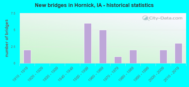
- New bridges - historical statistics
- 21910-1919
- 61950-1959
- 51960-1969
- 11970-1979
- 21980-1989
- 22000-2009
- 32010-2019

- Reconstructed bridges - Historical Statistics
- 11960-1969
- 01970-1979
- 31980-1989

- Bridge Condition - Deck
- 11.1%Excellent
- 5.6%Very good
- 16.7%Good
- 27.8%Satisfactory
- 22.2%Fair
- 5.6%Poor
- 11.1%Failed

- Bridge Condition - Superstructure
- 11.1%Excellent
- 16.7%Very good
- 5.6%Good
- 27.8%Satisfactory
- 27.8%Fair
- 11.1%Failed

- Bridge Condition - Substructure
- 5.6%Excellent
- 16.7%Very good
- 5.6%Good
- 27.8%Satisfactory
- 11.1%Fair
- 11.1%Poor
- 11.1%Serious
- 11.1%Failed

- Bridge Condition - Channel
- 23.8%Very good
- 38.1%Good
- 23.8%Satisfactory
- 14.3%Fair
Find on map >> Show street view
Structure Number: 53241, Location: 2.2 mi. W of SR K64 (Lat: 42.228156, Lng: -96.140817), Route carried "on" structure: State highway 141, Year Built: 2010, Status: Open, Structure Length: 3.79m (12.43ft), Average Daily Traffic: 1,920 (year 2020), Truck Traffic: 13%, Average Future Daily Traffic: 1,920 (year 2041), Design Load: HS 20, Features Intersected: DRAINAGE DITCH
Minimum Vertical Clearance: 30+ m (98+ ft), Kilometerpoint: 8.695, Lanes on structure: 2, Base Highway Network: Yes, Owner: State Highway Agency, Approaching Roadway Width: 13.4m (44.0ft), Skew: 3 degrees, Material/Design: Steel continuous, Design/Construction: Stringer/Multi-beam, Number Of Spans In Main Unit: 3, Length of Maximum Span: 14.3m (46.9ft), Curb-To-Curb Width: 9.1m (29.9ft), Out-to-Out Width: 9.8m (32.2ft)
Condition: Deck: Very good, Superstructure: Very good, Substructure: Good, Channel: Good, Operating Rating: 65.6 metric tons, Method Used To Determine Operating Rating: Load Factor (LF), Inventory Rating: 39.4 metric tons, Method Used To Determine Inventory Rating: Load Factor (LF), Structural Evaluation: Better than present minimum criteria, Deck Geometry: Somewhat better than minimum adequacy, Waterway Adequacy: Equal to present minimum criteria, Approach Roadway Alignment: Better than present minimum criteria, Designated Inspection Frequency: Every 24 months, Inspection Date: October 2021, Deck Structure Type: Concrete Cast-file-Place, Wearing Surface/Protective System: Wearing Surface: Monolithic Concrete, Deck Protection: Epoxy Coated Reinforcing
Find on map >> Show street view
Structure Number: 53251, Location: 6.4 MI. E. OF I-29 (Lat: 42.227397, Lng: -96.115675), Route carried "on" structure: State highway 141, Year Built: 2018, Status: Open, Structure Length: 4.20m (13.78ft), Average Daily Traffic: 1,920 (year 2020), Truck Traffic: 13%, Average Future Daily Traffic: 1,920 (year 2040), Design Load: HL 93, Features Intersected: GARRETSON DITCH
Minimum Vertical Clearance: 30+ m (98+ ft), Kilometerpoint: 10.773, Lanes on structure: 2, Base Highway Network: Yes, Owner: State Highway Agency, Approaching Roadway Width: 13.4m (44.0ft), Skew: 1 degrees, Material/Design: Concrete continuous, Design/Construction: Slab, Number Of Spans In Main Unit: 3, Length of Maximum Span: 18.2m (59.7ft), Curb-To-Curb Width: 13.4m (44.0ft), Out-to-Out Width: 14.4m (47.2ft)
Condition: Deck: Good, Superstructure: Good, Substructure: Very good, Channel: Very good, Operating Rating: 42.1 metric tons, Method Used To Determine Operating Rating: Assigned ratings based on Load and Resistance Factor Design (LRFD) reported by rating factor (RF) using HL93 loadings, Inventory Rating: 32.4 metric tons, Method Used To Determine Inventory Rating: Assigned ratings based on Load and Resistance Factor Design (LRFD) reported by rating factor (RF) using HL93 loadings, Structural Evaluation: Better than present minimum criteria, Deck Geometry: Equal to present desirable criteria, Waterway Adequacy: Superior to present desirable criteria, Approach Roadway Alignment: Equal to present desirable criteria, Designated Inspection Frequency: Every 24 months, Inspection Date: November 2020, Deck Structure Type: Concrete Cast-file-Place, Wearing Surface/Protective System: Wearing Surface: Monolithic Concrete, Deck Protection: Epoxy Coated Reinforcing
Find on map >> Show street view
Structure Number: 5326, Location: 0.3 mi. W of S.R. K64 (Lat: 42.227161, Lng: -96.103756), Route carried "on" structure: State highway 141, Year Built: 1952, Status: Open, Structure Length: 1.34m (4.40ft), Average Daily Traffic: 1,920 (year 2020), Truck Traffic: 13%, Average Future Daily Traffic: 1,920 (year 2040), Design Load: H 20, Features Intersected: FORK LITTLE SIOUX RIVER
Minimum Vertical Clearance: 30+ m (98+ ft), Kilometerpoint: 11.756, Lanes on structure: 2, Base Highway Network: Yes, Owner: State Highway Agency, Approaching Roadway Width: 13.4m (44.0ft), Material/Design: Concrete continuous, Design/Construction: Slab, Number Of Spans In Main Unit: 2, Length of Maximum Span: 6.7m (22.0ft), Curb-To-Curb Width: 9.1m (29.9ft), Out-to-Out Width: 10.6m (34.8ft)
Condition: Deck: Fair, Superstructure: Fair, Substructure: Satisfactory, Channel: Very good, Operating Rating: 47.3 metric tons, Method Used To Determine Operating Rating: Load Factor (LF), Inventory Rating: 28.4 metric tons, Method Used To Determine Inventory Rating: Load Factor (LF), Structural Evaluation: Somewhat better than minimum adequacy, Deck Geometry: Somewhat better than minimum adequacy, Waterway Adequacy: Equal to present desirable criteria, Approach Roadway Alignment: Equal to present desirable criteria, Designated Inspection Frequency: Every 24 months, Inspection Date: July 2020, Deck Structure Type: Concrete Cast-file-Place, Wearing Surface/Protective System: Wearing Surface: Low Slump Concrete
Find on map >> Show street view
Structure Number: 5328, Location: 1.2 mi. E of Jct. SR K64 (Lat: 42.226900, Lng: -96.074414), Route carried "on" structure: State highway 141, Year Built: 1959, Year Reconstructed: 1992, Status: Open, Structure Length: 0.76m (2.49ft), Average Daily Traffic: 1,340 (year 2020), Truck Traffic: 19%, Average Future Daily Traffic: 1,340 (year 2040), Design Load: HS 20, Features Intersected: DRAINAGE DITCH
Minimum Vertical Clearance: 30+ m (98+ ft), Kilometerpoint: 14.185, Lanes on structure: 2, Base Highway Network: Yes, Owner: State Highway Agency, Approaching Roadway Width: 13.4m (44.0ft), Material/Design: Concrete continuous, Design/Construction: Culvert, Number Of Spans In Main Unit: 2, Length of Maximum Span: 3.7m (12.1ft)
Condition: Channel: Very good, Culverts: Good, Operating Rating: 44.1 metric tons, Method Used To Determine Operating Rating: Field evaluation and documented engineering judgment, Inventory Rating: 32.7 metric tons, Method Used To Determine Inventory Rating: Field evaluation and documented engineering judgment, Structural Evaluation: Better than present minimum criteria, Waterway Adequacy: Better than present minimum criteria, Approach Roadway Alignment: Equal to present desirable criteria, Designated Inspection Frequency: Every 24 months, Inspection Date: October 2020
Find on map >> Show street view
Structure Number: 5329, Location: 1.5 mi. W of Jct. SR K67 (Lat: 42.226772, Lng: -96.063856), Route carried "on" structure: State highway 141, Year Built: 1959, Year Reconstructed: 1992, Status: Open, Structure Length: 0.76m (2.49ft), Average Daily Traffic: 1,340 (year 2020), Truck Traffic: 19%, Average Future Daily Traffic: 1,340 (year 2040), Design Load: H 20, Features Intersected: DRAINAGE DITCH
Minimum Vertical Clearance: 30+ m (98+ ft), Kilometerpoint: 15.055, Lanes on structure: 2, Base Highway Network: Yes, Owner: State Highway Agency, Approaching Roadway Width: 13.4m (44.0ft), Material/Design: Concrete continuous, Design/Construction: Culvert, Number Of Spans In Main Unit: 2, Length of Maximum Span: 3.7m (12.1ft)
Condition: Channel: Very good, Culverts: Good, Operating Rating: 24.5 metric tons, Method Used To Determine Operating Rating: Field evaluation and documented engineering judgment, Inventory Rating: 18.1 metric tons, Method Used To Determine Inventory Rating: Field evaluation and documented engineering judgment, Structural Evaluation: Somewhat better than minimum adequacy, Waterway Adequacy: Better than present minimum criteria, Approach Roadway Alignment: Equal to present desirable criteria, Designated Inspection Frequency: Every 24 months, Inspection Date: November 2020
Find on map >> Show street view
Structure Number: 533, Location: 2.0 mi. E of SR K64 (Lat: 42.226694, Lng: -96.058253), Route carried "on" structure: State highway 141, Year Built: 1959, Status: Open, Structure Length: 6.61m (21.69ft), Average Daily Traffic: 1,340 (year 2020), Truck Traffic: 19%, Average Future Daily Traffic: 1,340 (year 2040), Design Load: H 20, Features Intersected: WOLFE CREEK DITCH
Minimum Vertical Clearance: 30+ m (98+ ft), Kilometerpoint: 15.517, Lanes on structure: 2, Base Highway Network: Yes, Owner: State Highway Agency, Approaching Roadway Width: 13.4m (44.0ft), Skew: 2 degrees, Material/Design: Prestressed concrete, Design/Construction: Stringer/Multi-beam, Number Of Spans In Main Unit: 3, Length of Maximum Span: 21.6m (70.9ft), Curb-To-Curb Width: 10.3m (33.8ft), Out-to-Out Width: 11.0m (36.1ft)
Condition: Deck: Fair, Superstructure: Fair, Substructure: Satisfactory, Channel: Satisfactory, Operating Rating: 67.6 metric tons, Method Used To Determine Operating Rating: Load Factor (LF), Inventory Rating: 23.5 metric tons, Method Used To Determine Inventory Rating: Load Factor (LF), Structural Evaluation: Somewhat better than minimum adequacy, Deck Geometry: Somewhat better than minimum adequacy, Waterway Adequacy: Equal to present desirable criteria, Approach Roadway Alignment: Equal to present minimum criteria, Designated Inspection Frequency: Every 24 months, Inspection Date: October 2020, Deck Structure Type: Concrete Cast-file-Place, Wearing Surface/Protective System: Wearing Surface: Low Slump Concrete
Find on map >> Show street view
Structure Number: 5331, Location: 3.2 mi. E of jct. SR K64 (Lat: 42.228464, Lng: -96.035778), Route carried "on" structure: State highway 141, Year Built: 1959, Year Reconstructed: 1992, Status: Open, Structure Length: 0.88m (2.89ft), Average Daily Traffic: 1,340 (year 2020), Truck Traffic: 19%, Average Future Daily Traffic: 1,340 (year 2040), Design Load: H 20, Features Intersected: DRAINAGE DITCH
Minimum Vertical Clearance: 30+ m (98+ ft), Kilometerpoint: 17.399, Lanes on structure: 2, Base Highway Network: Yes, Owner: State Highway Agency, Approaching Roadway Width: 12.2m (40.0ft), Skew: 3 degrees, Material/Design: Concrete continuous, Design/Construction: Culvert, Number Of Spans In Main Unit: 2, Length of Maximum Span: 3.7m (12.1ft)
Condition: Channel: Good, Culverts: Good, Operating Rating: 69.0 metric tons, Method Used To Determine Operating Rating: Load and Resistance Factor Rating (LRFR) rating reported by rating factor(RF) method using HL-93 loadings, Inventory Rating: 53.1 metric tons, Method Used To Determine Inventory Rating: Load and Resistance Factor Rating (LRFR) rating reported by rating factor(RF) method using HL-93 loadings, Structural Evaluation: Better than present minimum criteria, Waterway Adequacy: Equal to present minimum criteria, Approach Roadway Alignment: Equal to present desirable criteria, Designated Inspection Frequency: Every 24 months, Inspection Date: October 2020
Find on map >> Show street view
Structure Number: 53551, Location: 086450918 (Lat: 42.270722, Lng: -96.079069), Route carried "on" structure: County highway , Year Built: 2002, Status: Open, Structure Length: 6.55m (21.49ft), Average Daily Traffic: 810 (year 2019), Truck Traffic: 21%, Average Future Daily Traffic: 810 (year 2040), Design Load: HS 20, Features Intersected: FORK OF LITTLE SIOUX, Facility Carried by Structure: OLD HWY 141
Minimum Vertical Clearance: 30+ m (98+ ft), Kilometerpoint: 13.781, Lanes on structure: 2, Owner: County Highway Agency, Approaching Roadway Width: 12.2m (40.0ft), Skew: 3 degrees, Material/Design: Prestressed concrete, Design/Construction: Stringer/Multi-beam, Number Of Spans In Main Unit: 3, Length of Maximum Span: 34.1m (111.9ft), Curb-To-Curb Width: 10.8m (35.4ft), Out-to-Out Width: 11.4m (37.4ft)
Condition: Deck: Good, Superstructure: Very good, Substructure: Very good, Channel: Good, Inventory Rating: 45.4 metric tons, Method Used To Determine Inventory Rating: Load Factor (LF), Structural Evaluation: Equal to present desirable criteria, Deck Geometry: Equal to present minimum criteria, Waterway Adequacy: Equal to present desirable criteria, Approach Roadway Alignment: Better than present minimum criteria, Length Of Structure Improvement: 21.50m (70.54ft), Designated Inspection Frequency: Every 24 months, Inspection Date: June 2020, Bridge Improvement Cost: $15,000, Roadway Improvement Cost: $2,000, Deck Structure Type: Concrete Cast-file-Place, Wearing Surface/Protective System: Wearing Surface: Monolithic Concrete
Find on map >> Show street view
Structure Number: 53561, Location: 086451407 (Lat: 42.264497, Lng: -96.053297), Route carried "on" structure: County highway , Year Built: 2002, Status: Open, Structure Length: 5.49m (18.01ft), Average Daily Traffic: 570 (year 2019), Truck Traffic: 18%, Average Future Daily Traffic: 570 (year 2038), Design Load: HS 20, Features Intersected: WOLF CREEK, Facility Carried by Structure: OLD HWY 141
Minimum Vertical Clearance: 30+ m (98+ ft), Kilometerpoint: 11.525, Lanes on structure: 2, Owner: County Highway Agency, Approaching Roadway Width: 12.2m (40.0ft), Skew: 3 degrees, Material/Design: Prestressed concrete, Design/Construction: Stringer/Multi-beam, Number Of Spans In Main Unit: 3, Length of Maximum Span: 20.4m (66.9ft), Curb-To-Curb Width: 10.8m (35.4ft), Out-to-Out Width: 11.4m (37.4ft)
Condition: Deck: Good, Superstructure: Very good, Substructure: Very good, Channel: Good, Operating Rating: 58.8 metric tons, Method Used To Determine Operating Rating: Load Factor (LF), Inventory Rating: 35.2 metric tons, Method Used To Determine Inventory Rating: Load Factor (LF), Structural Evaluation: Equal to present desirable criteria, Deck Geometry: Equal to present minimum criteria, Waterway Adequacy: Equal to present desirable criteria, Approach Roadway Alignment: Better than present minimum criteria, Length Of Structure Improvement: 18.00m (59.06ft), Designated Inspection Frequency: Every 48 months, Inspection Date: June 2018, Bridge Improvement Cost: $15,000, Roadway Improvement Cost: $2,000, Deck Structure Type: Concrete Cast-file-Place, Wearing Surface/Protective System: Wearing Surface: Monolithic Concrete
Find on map >> Show street view
Structure Number: 25148, Location: 085450401 (Lat: 42.212650, Lng: -96.078306), Route carried "on" structure: County highway , Year Built: 1912, Status: Closed, Structure Length: 3.66m (12.01ft), Average Daily Traffic: 35 (year 2019), Average Future Daily Traffic: 35 (year 2036), Features Intersected: WEST FORK DD, Facility Carried by Structure: LOCAL RD
Minimum Vertical Clearance: 30+ m (98+ ft), Kilometerpoint: 20.736, Lanes on structure: 1, Owner: County Highway Agency, Approaching Roadway Width: 7.3m (24.0ft), Material/Design: Steel, Design/Construction: Truss - Thru, Number Of Spans In Main Unit: 1, Number Of Approach Spans: 2, Length of Maximum Span: 24.4m (80.1ft), Curb-To-Curb Width: 4.8m (15.7ft), Out-to-Out Width: 4.9m (16.1ft)
Condition: Deck: Failed, Superstructure: Failed, Substructure: Failed, Channel: Good, Deck Geometry: Equal to present desirable criteria, Waterway Adequacy: Meets minimum limits, Approach Roadway Alignment: High priority of corrective action, Bridge Posting: Required (Relationship of Operating Rating to Maximum Legal Load: > 39.9% below), Length Of Structure Improvement: 15.00m (49.21ft), Designated Inspection Frequency: Every 24 months, Inspection Date: June 2016, Bridge Improvement Cost: $360,000, Roadway Improvement Cost: $36,000, Deck Structure Type: Wood or Timber, Wearing Surface/Protective System: Wearing Surface: Wood or Timber
Find on map >> Show street view
Structure Number: 25149, Location: 085450404 (Lat: 42.198892, Lng: -96.096914), Route carried "on" structure: County highway , Year Built: 1962, Status: Open, Structure Length: 6.68m (21.92ft), Average Daily Traffic: 580 (year 2019), Truck Traffic: 24%, Average Future Daily Traffic: 580 (year 2040), Design Load: H 15, Features Intersected: FAMERS GARRETSON DITCH, Facility Carried by Structure: FM
Minimum Vertical Clearance: 30+ m (98+ ft), Kilometerpoint: 12.823, Lanes on structure: 2, Owner: County Highway Agency, Approaching Roadway Width: 10.4m (34.1ft), Skew: 2 degrees, Material/Design: Prestressed concrete, Design/Construction: Stringer/Multi-beam, Number Of Spans In Main Unit: 3, Length of Maximum Span: 24.7m (81.0ft), Curb-To-Curb Width: 7.3m (24.0ft), Out-to-Out Width: 7.9m (25.9ft)
Condition: Deck: Poor, Superstructure: Fair, Substructure: Poor, Channel: Good, Operating Rating: 42.0 metric tons, Method Used To Determine Operating Rating: Allowable Stress (AS), Inventory Rating: 16.8 metric tons, Method Used To Determine Inventory Rating: Allowable Stress (AS), Structural Evaluation: Meets minimum limits, Deck Geometry: Meets minimum limits, Waterway Adequacy: Better than present minimum criteria, Approach Roadway Alignment: Equal to present desirable criteria, Length Of Structure Improvement: 25.00m (82.02ft), Designated Inspection Frequency: Every 24 months, Inspection Date: May 2020, Bridge Improvement Cost: $750,000, Roadway Improvement Cost: $75,000, Deck Structure Type: Concrete Cast-file-Place, Wearing Surface/Protective System: Wearing Surface: Monolithic Concrete
Find on map >> Show street view
Structure Number: 2515, Location: 085450501 (Lat: 42.212933, Lng: -96.106383), Route carried "on" structure: County highway , Year Built: 1913, Year Reconstructed: 1965, Status: Closed, Structure Length: 5.15m (16.90ft), Average Daily Traffic: 10 (year 2019), Average Future Daily Traffic: 10 (year 2036), Features Intersected: FARMERS GARRETSON DD, Facility Carried by Structure: 100TH ST
Minimum Vertical Clearance: 30+ m (98+ ft), Kilometerpoint: 18.419, Lanes on structure: 2, Owner: County Highway Agency, Approaching Roadway Width: 7.6m (24.9ft), Material/Design: Steel, Design/Construction: Truss - Thru, Number Of Spans In Main Unit: 1, Number Of Approach Spans: 2, Length of Maximum Span: 30.5m (100.1ft), Curb-To-Curb Width: 4.9m (16.1ft), Out-to-Out Width: 5.0m (16.4ft)
Condition: Deck: Failed, Superstructure: Failed, Substructure: Failed, Channel: Good, Deck Geometry: High priority of corrective action, Waterway Adequacy: Equal to present minimum criteria, Approach Roadway Alignment: Meets minimum limits, Bridge Posting: Required (Relationship of Operating Rating to Maximum Legal Load: > 39.9% below), Length Of Structure Improvement: 20.00m (65.62ft), Designated Inspection Frequency: Every 24 months, Inspection Date: June 2016, Bridge Improvement Cost: $480,000, Roadway Improvement Cost: $48,000, Deck Structure Type: Wood or Timber, Wearing Surface/Protective System: Wearing Surface: Wood or Timber
Find on map >> Show street view
Structure Number: 25152, Location: 085450903 (Lat: 42.198508, Lng: -96.078714), Route carried "on" structure: County highway , Year Built: 1961, Status: Open, Structure Length: 5.15m (16.90ft), Average Daily Traffic: 45 (year 2016), Average Future Daily Traffic: 45 (year 2040), Design Load: H 15, Features Intersected: WEST FORK DD, Facility Carried by Structure: LOCAL
Minimum Vertical Clearance: 30+ m (98+ ft), Kilometerpoint: 20.598, Lanes on structure: 2, Owner: County Highway Agency, Approaching Roadway Width: 6.7m (22.0ft), Material/Design: Prestressed concrete, Design/Construction: Stringer/Multi-beam, Number Of Spans In Main Unit: 3, Length of Maximum Span: 17.1m (56.1ft), Curb or Sidewalk Widths: Left: 0.3m (1.0ft), Right: 0.3m (1.0ft), Curb-To-Curb Width: 6.1m (20.0ft), Out-to-Out Width: 6.7m (22.0ft)
Condition: Deck: Satisfactory, Superstructure: Satisfactory, Substructure: Poor, Channel: Satisfactory, Operating Rating: 37.9 metric tons, Method Used To Determine Operating Rating: Allowable Stress (AS), Inventory Rating: 17.1 metric tons, Method Used To Determine Inventory Rating: Allowable Stress (AS), Structural Evaluation: Meets minimum limits, Deck Geometry: Somewhat better than minimum adequacy, Waterway Adequacy: Equal to present minimum criteria, Approach Roadway Alignment: Somewhat better than minimum adequacy, Length Of Structure Improvement: 25.00m (82.02ft), Designated Inspection Frequency: Every 24 months, Inspection Date: May 2020, Bridge Improvement Cost: $600,000, Roadway Improvement Cost: $60,000, Deck Structure Type: Concrete Cast-file-Place, Wearing Surface/Protective System: Wearing Surface: Monolithic Concrete
Find on map >> Show street view
Structure Number: 25153, Location: 085451201 (Lat: 42.197925, Lng: -96.039622), Route carried "on" structure: County highway , Year Built: 1962, Status: Open, Structure Length: 5.15m (16.90ft), Average Daily Traffic: 20 (year 2016), Average Future Daily Traffic: 20 (year 2040), Design Load: H 15, Features Intersected: HAITZ DD, Facility Carried by Structure: LOCAL
Minimum Vertical Clearance: 30+ m (98+ ft), Kilometerpoint: 23.826, Lanes on structure: 2, Owner: County Highway Agency, Approaching Roadway Width: 7.9m (25.9ft), Material/Design: Prestressed concrete, Design/Construction: Stringer/Multi-beam, Number Of Spans In Main Unit: 3, Length of Maximum Span: 17.1m (56.1ft), Curb or Sidewalk Widths: Left: 0.3m (1.0ft), Right: 0.3m (1.0ft), Curb-To-Curb Width: 6.1m (20.0ft), Out-to-Out Width: 6.7m (22.0ft)
Condition: Deck: Satisfactory, Superstructure: Satisfactory, Substructure: Satisfactory, Channel: Good, Operating Rating: 53.9 metric tons, Method Used To Determine Operating Rating: Allowable Stress (AS), Inventory Rating: 27.1 metric tons, Method Used To Determine Inventory Rating: Allowable Stress (AS), Structural Evaluation: Equal to present minimum criteria, Deck Geometry: Somewhat better than minimum adequacy, Waterway Adequacy: Equal to present minimum criteria, Approach Roadway Alignment: Somewhat better than minimum adequacy, Length Of Structure Improvement: 20.00m (65.62ft), Designated Inspection Frequency: Every 24 months, Inspection Date: May 2020, Bridge Improvement Cost: $650,000, Roadway Improvement Cost: $5,000, Deck Structure Type: Concrete Cast-file-Place, Wearing Surface/Protective System: Wearing Surface: Monolithic Concrete
Find on map >> Show street view
Structure Number: 3365, Location: 075080902 (Lat: 41.319381, Lng: -91.792947), Route carried "on" structure: County highway , Year Built: 1969, Status: Open, Structure Length: 1.40m (4.59ft), Average Daily Traffic: 25 (year 2018), Average Future Daily Traffic: 25 (year 2041), Design Load: H 20, Features Intersected: CLEMONS CREEK, Facility Carried by Structure: LOCAL ROAD
Minimum Vertical Clearance: 30+ m (98+ ft), Kilometerpoint: 14.618, Lanes on structure: 2, Owner: County Highway Agency, Approaching Roadway Width: 7.3m (24.0ft), Material/Design: Prestressed concrete, Design/Construction: Stringer/Multi-beam, Number Of Spans In Main Unit: 1, Length of Maximum Span: 13.1m (43.0ft), Curb or Sidewalk Widths: Left: 0.3m (1.0ft), Right: 0.3m (1.0ft), Curb-To-Curb Width: 8.6m (28.2ft), Out-to-Out Width: 9.2m (30.2ft)
Condition: Deck: Satisfactory, Superstructure: Satisfactory, Substructure: Fair, Channel: Satisfactory, Operating Rating: 51.1 metric tons, Method Used To Determine Operating Rating: Allowable Stress (AS), Inventory Rating: 33.0 metric tons, Method Used To Determine Inventory Rating: Allowable Stress (AS), Structural Evaluation: Somewhat better than minimum adequacy, Deck Geometry: Better than present minimum criteria, Waterway Adequacy: Equal to present minimum criteria, Approach Roadway Alignment: Better than present minimum criteria, Length Of Structure Improvement: 4.60m (15.09ft), Designated Inspection Frequency: Every 24 months, Inspection Date: March 2021, Bridge Improvement Cost: $15,000, Roadway Improvement Cost: $2,000, Deck Structure Type: Concrete Cast-file-Place, Wearing Surface/Protective System: Wearing Surface: Monolithic Concrete
Find on map >> Show street view
Structure Number: 33794, Location: 077091104 (Lat: 41.491139, Lng: -91.863142), Route carried "on" structure: County highway , Year Built: 1965, Year Reconstructed: 2021, Status: Open, Structure Length: 0.79m (2.59ft), Average Daily Traffic: 25 (year 2018), Average Future Daily Traffic: 25 (year 2041), Design Load: HL 93, Features Intersected: SMALL STREAM, Facility Carried by Structure: LOCAL
Minimum Vertical Clearance: 30+ m (98+ ft), Kilometerpoint: 32.293, Lanes on structure: 2, Owner: County Highway Agency, Approaching Roadway Width: 6.7m (22.0ft), Material/Design: Steel, Design/Construction: Stringer/Multi-beam, Number Of Spans In Main Unit: 1, Length of Maximum Span: 7.6m (24.9ft), Curb-To-Curb Width: 7.4m (24.3ft), Out-to-Out Width: 7.6m (24.9ft)
Condition: Deck: Excellent, Superstructure: Excellent, Substructure: Fair, Channel: Fair, Operating Rating: 42.1 metric tons, Method Used To Determine Operating Rating: Assigned ratings based on Load and Resistance Factor Design (LRFD) reported by rating factor (RF) using HL93 loadings, Inventory Rating: 32.4 metric tons, Method Used To Determine Inventory Rating: Assigned ratings based on Load and Resistance Factor Design (LRFD) reported by rating factor (RF) using HL93 loadings, Structural Evaluation: Somewhat better than minimum adequacy, Deck Geometry: Equal to present minimum criteria, Waterway Adequacy: Somewhat better than minimum adequacy, Approach Roadway Alignment: Better than present minimum criteria, Length Of Structure Improvement: 5.00m (16.40ft), Designated Inspection Frequency: Every 12 months, Inspection Date: March 2021, Bridge Improvement Cost: $142,000, Roadway Improvement Cost: $14,000, Deck Structure Type: Corrugated Steel, Wearing Surface/Protective System: Wearing Surface: Gravel
Find on map >> Show street view
Structure Number: 35096, Location: 086450701 (Lat: 42.284944, Lng: -96.121761), Route carried "on" structure: County highway , Year Built: 1970, Status: Posted for load, Structure Length: 3.14m (10.30ft), Average Daily Traffic: 20 (year 2019), Average Future Daily Traffic: 20 (year 2041), Features Intersected: GARRETSON DRAINAGE DITCH, Facility Carried by Structure: LOCAL
Minimum Vertical Clearance: 30+ m (98+ ft), Kilometerpoint: 16.814, Lanes on structure: 2, Owner: County Highway Agency, Approaching Roadway Width: 8.2m (26.9ft), Material/Design: Steel, Design/Construction: Stringer/Multi-beam, Number Of Spans In Main Unit: 3, Length of Maximum Span: 15.5m (50.9ft), Curb-To-Curb Width: 5.9m (19.4ft), Out-to-Out Width: 6.0m (19.7ft)
Condition: Deck: Fair, Superstructure: Fair, Substructure: Serious, Channel: Satisfactory, Operating Rating: 6.3 metric tons, Method Used To Determine Operating Rating: Allowable Stress (AS), Structural Evaluation: High priority of replacement, Deck Geometry: Meets minimum limits, Waterway Adequacy: Better than present minimum criteria, Approach Roadway Alignment: Equal to present minimum criteria, Bridge Posting: Required (Relationship of Operating Rating to Maximum Legal Load: > 39.9% below), Length Of Structure Improvement: 15.00m (49.21ft), Designated Inspection Frequency: Every 12 months, Inspection Date: May 2021, Bridge Improvement Cost: $404,000, Roadway Improvement Cost: $40,000, Deck Structure Type: Wood or Timber, Wearing Surface/Protective System: Wearing Surface: Gravel
Find on map >> Show street view
Structure Number: 351021, Location: 086451901 (Lat: 42.255994, Lng: -96.121994), Route carried "on" structure: County highway , Year Built: 1984, Status: Open, Structure Length: 3.87m (12.70ft), Average Daily Traffic: 30 (year 2019), Average Future Daily Traffic: 30 (year 2040), Design Load: H 15, Features Intersected: GARRETSON DRAINAGE DITCH, Facility Carried by Structure: LOCAL
Minimum Vertical Clearance: 30+ m (98+ ft), Kilometerpoint: 15.125, Lanes on structure: 2, Owner: County Highway Agency, Approaching Roadway Width: 10.7m (35.1ft), Material/Design: Concrete continuous, Design/Construction: Slab, Number Of Spans In Main Unit: 3, Length of Maximum Span: 14.9m (48.9ft), Curb-To-Curb Width: 7.3m (24.0ft), Out-to-Out Width: 8.0m (26.2ft)
Condition: Deck: Satisfactory, Superstructure: Satisfactory, Substructure: Satisfactory, Channel: Satisfactory, Operating Rating: 37.2 metric tons, Method Used To Determine Operating Rating: Load Factor (LF), Inventory Rating: 22.3 metric tons, Method Used To Determine Inventory Rating: Load Factor (LF), Structural Evaluation: Equal to present minimum criteria, Deck Geometry: Equal to present minimum criteria, Waterway Adequacy: Better than present minimum criteria, Approach Roadway Alignment: Equal to present minimum criteria, Length Of Structure Improvement: 12.70m (41.67ft), Designated Inspection Frequency: Every 24 months, Inspection Date: June 2020, Bridge Improvement Cost: $15,000, Roadway Improvement Cost: $2,000, Deck Structure Type: Concrete Cast-file-Place, Wearing Surface/Protective System: Wearing Surface: Monolithic Concrete
Find on map >> Show street view
Structure Number: 35103, Location: 086452503 (Lat: 42.230739, Lng: -96.032539), Route carried "on" structure: County highway , Year Built: 1952, Status: Posted for load, Structure Length: 3.93m (12.89ft), Average Daily Traffic: 45 (year 2019), Average Future Daily Traffic: 45 (year 2041), Design Load: H 15, Features Intersected: STREAM, Facility Carried by Structure: LOCAL
Minimum Vertical Clearance: 30+ m (98+ ft), Kilometerpoint: 3.700, Lanes on structure: 2, Owner: County Highway Agency, Approaching Roadway Width: 9.1m (29.9ft), Skew: 4 degrees, Material/Design: Steel, Design/Construction: Stringer/Multi-beam, Number Of Spans In Main Unit: 3, Length of Maximum Span: 12.8m (42.0ft), Curb-To-Curb Width: 6.1m (20.0ft), Out-to-Out Width: 6.7m (22.0ft)
Condition: Deck: Fair, Superstructure: Satisfactory, Substructure: Serious, Channel: Fair, Operating Rating: 12.2 metric tons, Method Used To Determine Operating Rating: Allowable Stress (AS), Inventory Rating: 5.1 metric tons, Method Used To Determine Inventory Rating: Allowable Stress (AS), Structural Evaluation: High priority of replacement, Deck Geometry: Somewhat better than minimum adequacy, Waterway Adequacy: Better than present minimum criteria, Approach Roadway Alignment: Equal to present minimum criteria, Bridge Posting: Required (Relationship of Operating Rating to Maximum Legal Load: > 39.9% below), Length Of Structure Improvement: 16.40m (53.81ft), Designated Inspection Frequency: Every 12 months, Inspection Date: May 2021, Bridge Improvement Cost: $442,000, Roadway Improvement Cost: $44,000, Deck Structure Type: Concrete Cast-file-Place, Wearing Surface/Protective System: Wearing Surface: Monolithic Concrete
Find on map >> Show street view
Structure Number: 351071, Location: 086452701 (Lat: 42.241281, Lng: -96.059272), Route carried "on" structure: County highway , Year Built: 2019, Status: Open, Structure Length: 3.75m (12.30ft), Average Daily Traffic: 5 (year 2019), Average Future Daily Traffic: 5 (year 2041), Design Load: HL 93, Features Intersected: WOLF CREEK, Facility Carried by Structure: 320TH ST
Minimum Vertical Clearance: 30+ m (98+ ft), Kilometerpoint: 19.307, Lanes on structure: 2, Owner: County Highway Agency, Approaching Roadway Width: 8.5m (27.9ft), Material/Design: Concrete continuous, Design/Construction: Slab, Number Of Spans In Main Unit: 3, Length of Maximum Span: 14.3m (46.9ft), Curb-To-Curb Width: 7.5m (24.6ft), Out-to-Out Width: 8.3m (27.2ft)
Condition: Deck: Excellent, Superstructure: Excellent, Substructure: Excellent, Channel: Very good, Operating Rating: 42.1 metric tons, Method Used To Determine Operating Rating: Assigned ratings based on Load and Resistance Factor Design (LRFD) reported by rating factor (RF) using HL93 loadings, Inventory Rating: 32.4 metric tons, Method Used To Determine Inventory Rating: Assigned ratings based on Load and Resistance Factor Design (LRFD) reported by rating factor (RF) using HL93 loadings, Structural Evaluation: Equal to present desirable criteria, Deck Geometry: Equal to present minimum criteria, Waterway Adequacy: Better than present minimum criteria, Approach Roadway Alignment: Somewhat better than minimum adequacy, Designated Inspection Frequency: Every 24 months, Inspection Date: May 2021, Deck Structure Type: Concrete Cast-file-Place, Wearing Surface/Protective System: Wearing Surface: Monolithic Concrete, Deck Protection: Epoxy Coated Reinforcing
Find on map >> Show street view
Structure Number: 351151, Location: 086462401 (Lat: 42.256856, Lng: -96.144994), Route carried "on" structure: County highway , Year Built: 1980, Status: Posted for load, Structure Length: 3.54m (11.61ft), Average Daily Traffic: 20 (year 2019), Average Future Daily Traffic: 20 (year 2040), Features Intersected: FARMERS DITCH, Facility Carried by Structure: LOCAL
Minimum Vertical Clearance: 30+ m (98+ ft), Kilometerpoint: 13.224, Lanes on structure: 2, Owner: County Highway Agency, Approaching Roadway Width: 7.6m (24.9ft), Material/Design: Steel, Design/Construction: Stringer/Multi-beam, Number Of Spans In Main Unit: 1, Number Of Approach Spans: 4, Length of Maximum Span: 12.5m (41.0ft), Curb-To-Curb Width: 7.3m (24.0ft), Out-to-Out Width: 7.3m (24.0ft)
Condition: Deck: Satisfactory, Superstructure: Fair, Substructure: Satisfactory, Channel: Fair, Operating Rating: 34.6 metric tons, Method Used To Determine Operating Rating: Allowable Stress (AS), Inventory Rating: 23.4 metric tons, Method Used To Determine Inventory Rating: Allowable Stress (AS), Structural Evaluation: Somewhat better than minimum adequacy, Deck Geometry: Equal to present minimum criteria, Waterway Adequacy: Better than present minimum criteria, Approach Roadway Alignment: Somewhat better than minimum adequacy, Bridge Posting: Required (Relationship of Operating Rating to Maximum Legal Load: 0.1 - 9.9% below), Length Of Structure Improvement: 15.00m (49.21ft), Designated Inspection Frequency: Every 24 months, Inspection Date: June 2020, Bridge Improvement Cost: $404,000, Roadway Improvement Cost: $40,000, Deck Structure Type: Wood or Timber, Wearing Surface/Protective System: Wearing Surface: Gravel