Bridge Statistics for Idaho Springs, Colorado (CO)
Condition, Traffic, Stress, Structural Evaluation, Project Costs
- National Bridge Inventory (NBI) Statistics
- 28Number of bridges
- 344ft / 105mTotal length
- $1,772,000Total costs
- 585,553Total average daily traffic
- 43,301Total average daily truck traffic
- National Bridge Inventory (NBI) Registered Bridges for Idaho Springs
- No street view available for this location
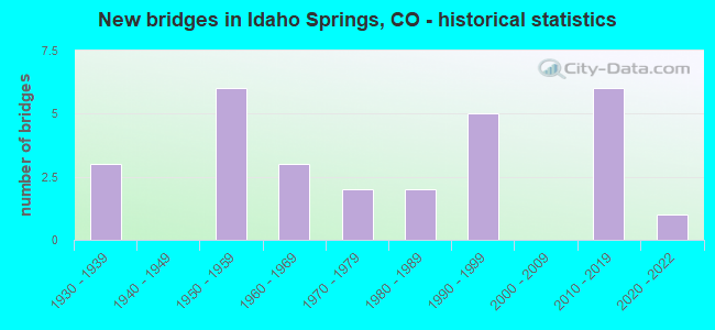
- New bridges - historical statistics
- 31930-1939
- 61950-1959
- 31960-1969
- 21970-1979
- 21980-1989
- 51990-1999
- 62010-2019
- 12020-2022

- Reconstructed bridges - Historical Statistics
- 11970-1979
- 41980-1989


- Bridge Condition - Deck
- 4.5%Very good
- 36.4%Good
- 50.0%Satisfactory
- 4.5%Fair
- 4.5%Poor

- Bridge Condition - Superstructure
- 13.6%Very good
- 50.0%Good
- 31.8%Satisfactory
- 4.5%Fair

- Bridge Condition - Substructure
- 9.1%Very good
- 50.0%Good
- 27.3%Satisfactory
- 13.6%Fair

- Bridge Condition - Channel
- 89.5%Very good
- 5.3%Good
- 5.3%Fair

- Bridge Condition - Culverts
- 66.7%Good
- 33.3%Satisfactory
Find on map >> Show street view
Structure Number: CLR312-1.1, Location: 2.3 MI W of IDAHO SPRINGS (Lat: 39.751847, Lng: -105.554139), Route carried "on" structure: City street , Year Built: 2020, Status: Open, Structure Length: 1.95m (6.40ft), Average Daily Traffic: 72 (year 2020), Average Future Daily Traffic: 90 (year 2040), Design Load: HL 93, Features Intersected: CLEAR CREEK, Facility Carried by Structure: FALL RIVER ROAD
Minimum Vertical Clearance: 30+ m (98+ ft), Kilometerpoint: 4.197, Lanes on structure: 2, Owner: County Highway Agency, Approaching Roadway Width: 7.9m (25.9ft), Material/Design: Prestressed concrete, Design/Construction: Box Beam or Girders - Multiple, Number Of Spans In Main Unit: 1, Length of Maximum Span: 17.7m (58.1ft), Curb or Sidewalk Widths: Left: 3.0m (9.8ft), Right: 0.0m, Curb-To-Curb Width: 7.9m (25.9ft), Out-to-Out Width: 23.0m (75.5ft)
Condition: Deck: Very good, Superstructure: Good, Substructure: Very good, Channel: Very good, Operating Rating: 61.2 metric tons, Method Used To Determine Operating Rating: Load and Resistance Factor Rating (LRFR) rating reported by rating factor(RF) method using HL-93 loadings, Inventory Rating: 47.3 metric tons, Method Used To Determine Inventory Rating: Load and Resistance Factor Rating (LRFR) rating reported by rating factor(RF) method using HL-93 loadings, Structural Evaluation: Better than present minimum criteria, Deck Geometry: Equal to present minimum criteria, Waterway Adequacy: Equal to present desirable criteria, Approach Roadway Alignment: Equal to present minimum criteria, Designated Inspection Frequency: Every 24 months, Inspection Date: April 2021, Deck Structure Type: Concrete Cast-file-Place, Wearing Surface/Protective System: Wearing Surface: Bituminous, Membrane: Built-up, Deck Protection: Epoxy Coated Reinforcing
Find on map >> Show street view
Structure Number: CLR314-W0.7, Location: 1.5 MI E OF IDAHO SPRINGS (Lat: 39.742886, Lng: -105.473700), Route carried "on" structure: County highway , Year Built: 1936, Status: Open, Structure Length: 4.11m (13.48ft), Average Daily Traffic: 111 (year 2020), Average Future Daily Traffic: 139 (year 2040), Design Load: H 15, Features Intersected: CLEAR CREEK, Facility Carried by Structure: COUNTY ROAD 314
Minimum Vertical Clearance: 30+ m (98+ ft), Kilometerpoint: 2.005, Lanes on structure: 2, Owner: County Highway Agency, Approaching Roadway Width: 7.3m (24.0ft), Skew: 9 degrees, Material/Design: Steel, Design/Construction: Stringer/Multi-beam, Number Of Spans In Main Unit: 2, Length of Maximum Span: 19.9m (65.3ft), Curb-To-Curb Width: 10.8m (35.4ft), Out-to-Out Width: 11.9m (39.0ft)
Condition: Deck: Satisfactory, Superstructure: Good, Substructure: Satisfactory, Channel: Very good, Operating Rating: 34.1 metric tons, Method Used To Determine Operating Rating: Load Factor (LF), Inventory Rating: 20.5 metric tons, Method Used To Determine Inventory Rating: Load Factor (LF), Structural Evaluation: Somewhat better than minimum adequacy, Deck Geometry: Better than present minimum criteria, Waterway Adequacy: Equal to present desirable criteria, Approach Roadway Alignment: Better than present minimum criteria, Designated Inspection Frequency: Every 24 months, Inspection Date: April 2021, Deck Structure Type: Concrete Cast-file-Place, Wearing Surface/Protective System: Wearing Surface: Bituminous
Find on map >> Show street view
Structure Number: E-14-AY, Location: 2 MI W OF JCT SH 103 (Lat: 39.752683, Lng: -105.554139), Route carried "on" structure: Interstate 70A, Year Built: 1965, Year Reconstructed: 1987, Status: Open, Structure Length: 6.83m (22.41ft), Average Daily Traffic: 18,000 (year 2020), Truck Traffic: 8%, Average Future Daily Traffic: 21,240 (year 2040), Design Load: HS 20, Features Intersected: FALL RIVER ROAD, Facility Carried by Structure: I 70 ML WBND
Minimum Vertical Clearance: 30+ m (98+ ft), Kilometerpoint: 384.054, Lanes on structure: 2, Lanes under structure: 2, Base Highway Network: Yes, Owner: State Highway Agency, Approaching Roadway Width: 11.6m (38.1ft), Skew: 16 degrees, Material/Design: Concrete, Design/Construction: Tee Beam, Number Of Spans In Main Unit: 5, Length of Maximum Span: 18.5m (60.7ft), Curb-To-Curb Width: 11.6m (38.1ft), Out-to-Out Width: 12.6m (41.3ft)
Condition: Deck: Satisfactory, Superstructure: Satisfactory, Substructure: Satisfactory, Operating Rating: 52.1 metric tons, Method Used To Determine Operating Rating: Load Factor (LF), Inventory Rating: 31.1 metric tons, Method Used To Determine Inventory Rating: Load Factor (LF), Structural Evaluation: Equal to present minimum criteria, Deck Geometry: Equal to present minimum criteria, Underclear: High priority of corrective action, Approach Roadway Alignment: Equal to present desirable criteria, Length Of Structure Improvement: 6.83m (22.41ft), Designated Inspection Frequency: Every 24 months, Inspection Date: August 2021, Bridge Improvement Cost: $1,000, Total Project Cost: $2,000, Deck Structure Type: Other, Wearing Surface/Protective System: Wearing Surface: Bituminous, Membrane: Preformed Fabric
Find on map >> Show street view
Structure Number: E-14-AZ, Location: 5.9 MI E OF JCT US 40 (Lat: 39.752375, Lng: -105.554081), Route carried "on" structure: Interstate 70A, Year Built: 1965, Year Reconstructed: 1987, Status: Open, Structure Length: 5.64m (18.50ft), Average Daily Traffic: 18,000 (year 2020), Truck Traffic: 8%, Average Future Daily Traffic: 21,240 (year 2040), Design Load: HS 20, Features Intersected: FALL RIVER ROAD, Facility Carried by Structure: I 70 ML EBND
Minimum Vertical Clearance: 30+ m (98+ ft), Kilometerpoint: 384.083, Lanes on structure: 3, Lanes under structure: 2, Base Highway Network: Yes, Owner: State Highway Agency, Approaching Roadway Width: 11.6m (38.1ft), Skew: 16 degrees, Material/Design: Concrete, Design/Construction: Tee Beam, Number Of Spans In Main Unit: 4, Length of Maximum Span: 17.1m (56.1ft), Curb-To-Curb Width: 11.6m (38.1ft), Out-to-Out Width: 12.6m (41.3ft)
Condition: Deck: Satisfactory, Superstructure: Good, Substructure: Good, Operating Rating: 55.1 metric tons, Method Used To Determine Operating Rating: Load Factor (LF), Inventory Rating: 32.9 metric tons, Method Used To Determine Inventory Rating: Load Factor (LF), Structural Evaluation: Better than present minimum criteria, Deck Geometry: High priority of replacement, Underclear: High priority of corrective action, Approach Roadway Alignment: Equal to present desirable criteria, Designated Inspection Frequency: Every 24 months, Inspection Date: August 2021, Deck Structure Type: Concrete Cast-file-Place, Wearing Surface/Protective System: Wearing Surface: Bituminous, Membrane: Preformed Fabric
Find on map >> Show street view
Structure Number: F-14-AZ, Location: W inter. of Idaho Springs (Lat: 39.743603, Lng: -105.535736), Route carried "on" structure: ServiceInterstate 70A, Year Built: 2010, Status: Open, Structure Length: 3.65m (11.98ft), Average Daily Traffic: 36,000 (year 2020), Truck Traffic: 8%, Average Future Daily Traffic: 42,480 (year 2040), Design Load: HL 93, Features Intersected: CLEAR CREEK SR, Facility Carried by Structure: I 70 FRONTAGE RD
Minimum Vertical Clearance: 30+ m (98+ ft), Kilometerpoint: 6.135, Lanes on structure: 2, Base Highway Network: Yes, Owner: State Highway Agency, Approaching Roadway Width: 9.1m (29.9ft), Skew: 4 degrees, Material/Design: Prestressed concrete, Design/Construction: Box Beam or Girders - Multiple, Number Of Spans In Main Unit: 1, Length of Maximum Span: 34.1m (111.9ft), Curb-To-Curb Width: 12.3m (40.4ft), Out-to-Out Width: 13.2m (43.3ft)
Condition: Deck: Good, Superstructure: Good, Substructure: Good, Channel: Very good, Operating Rating: 96.9 metric tons, Method Used To Determine Operating Rating: Load and Resistance Factor Rating (LRFR) rating reported by rating factor(RF) method using HL-93 loadings, Inventory Rating: 94.0 metric tons, Method Used To Determine Inventory Rating: Load and Resistance Factor Rating (LRFR) rating reported by rating factor(RF) method using HL-93 loadings, Structural Evaluation: Better than present minimum criteria, Deck Geometry: Somewhat better than minimum adequacy, Waterway Adequacy: Equal to present desirable criteria, Approach Roadway Alignment: Equal to present desirable criteria, Length Of Structure Improvement: 3.84m (12.60ft), Designated Inspection Frequency: Every 24 months, Inspection Date: August 2021, Bridge Improvement Cost: $559,000, Roadway Improvement Cost: $56,000, Total Project Cost: $839,000, Deck Structure Type: Concrete Cast-file-Place, Wearing Surface/Protective System: Wearing Surface: Bituminous, Membrane: Built-up, Deck Protection: Epoxy Coated Reinforcing
Find on map >> Show street view
Structure Number: F-14-G, Location: IN IDAHO SPRINGS (Lat: 39.740039, Lng: -105.521194), Route carried "on" structure: State highway 103A, Year Built: 1958, Status: Open, Structure Length: 3.32m (10.89ft), Average Daily Traffic: 2,300 (year 2020), Truck Traffic: 2%, Average Future Daily Traffic: 3,013 (year 2040), Design Load: HS 20, Features Intersected: CLEAR CREEK, Facility Carried by Structure: SH 103 ML
Minimum Vertical Clearance: 30+ m (98+ ft), Kilometerpoint: 0.224, Lanes on structure: 2, Owner: State Highway Agency, Approaching Roadway Width: 7.6m (24.9ft), Skew: 2 degrees, Material/Design: Concrete, Design/Construction: Tee Beam, Number Of Spans In Main Unit: 3, Length of Maximum Span: 10.7m (35.1ft), Curb or Sidewalk Widths: Left: 0.0m, Right: 1.8m (5.9ft), Curb-To-Curb Width: 8.8m (28.9ft), Out-to-Out Width: 11.6m (38.1ft)
Condition: Deck: Fair, Superstructure: Satisfactory, Substructure: Fair, Channel: Very good, Operating Rating: 56.6 metric tons, Method Used To Determine Operating Rating: Load Factor (LF), Inventory Rating: 33.9 metric tons, Method Used To Determine Inventory Rating: Load Factor (LF), Structural Evaluation: Somewhat better than minimum adequacy, Deck Geometry: Meets minimum limits, Waterway Adequacy: Equal to present desirable criteria, Approach Roadway Alignment: Equal to present desirable criteria, Designated Inspection Frequency: Every 24 months, Inspection Date: August 2021, Deck Structure Type: Concrete Cast-file-Place, Wearing Surface/Protective System: Wearing Surface: Bituminous, Membrane: Built-up
Find on map >> Show street view
Structure Number: F-14-H, Location: 7.4 MI E OF JCT US 40 (Lat: 39.744011, Lng: -105.534264), Route carried "on" structure: Interstate 70A, Year Built: 1958, Status: Open, Structure Length: 4.97m (16.31ft), Average Daily Traffic: 36,000 (year 2020), Truck Traffic: 8%, Average Future Daily Traffic: 42,480 (year 2040), Design Load: HS 20, Features Intersected: I 70 BUSS RT, Facility Carried by Structure: I 70 ML
Minimum Vertical Clearance: 30+ m (98+ ft), Kilometerpoint: 386.043, Lanes on structure: 4, Lanes under structure: 2, Base Highway Network: Yes, Owner: State Highway Agency, Approaching Roadway Width: 23.2m (76.1ft), Skew: 33 degrees, Material/Design: Concrete, Design/Construction: Tee Beam, Number Of Spans In Main Unit: 3, Length of Maximum Span: 16.2m (53.1ft), Curb-To-Curb Width: 23.2m (76.1ft), Out-to-Out Width: 26.4m (86.6ft)
Condition: Deck: Satisfactory, Superstructure: Satisfactory, Substructure: Fair, Operating Rating: 61.2 metric tons, Method Used To Determine Operating Rating: Load Factor (LF), Inventory Rating: 36.7 metric tons, Method Used To Determine Inventory Rating: Load Factor (LF), Structural Evaluation: Somewhat better than minimum adequacy, Deck Geometry: Superior to present desirable criteria, Underclear: Meets minimum limits, Approach Roadway Alignment: Equal to present desirable criteria, Designated Inspection Frequency: Every 24 months, Inspection Date: August 2021, Deck Structure Type: Other, Wearing Surface/Protective System: Wearing Surface: Bituminous, Membrane: Preformed Fabric
Find on map >> Show street view
Structure Number: F-14-N, Location: IN IDAHO SPRINGS (Lat: 39.741306, Lng: -105.514417), Route carried "on" structure: Interstate 70A, Year Built: 1971, Year Reconstructed: 1987, Status: Open, Structure Length: 6.45m (21.16ft), Average Daily Traffic: 39,000 (year 2020), Truck Traffic: 8%, Average Future Daily Traffic: 47,970 (year 2040), Design Load: HS 20+Mod, Features Intersected: CLEAR CREEK, Facility Carried by Structure: I 70 ML
Minimum Vertical Clearance: 30+ m (98+ ft), Kilometerpoint: 387.802, Lanes on structure: 5, Base Highway Network: Yes, Owner: State Highway Agency, Approaching Roadway Width: 23.2m (76.1ft), Skew: 25 degrees, Material/Design: Concrete continuous, Design/Construction: Tee Beam, Number Of Spans In Main Unit: 3, Length of Maximum Span: 26.2m (86.0ft), Curb-To-Curb Width: 23.2m (76.1ft), Out-to-Out Width: 24.5m (80.4ft)
Condition: Deck: Satisfactory, Superstructure: Satisfactory, Substructure: Satisfactory, Channel: Very good, Operating Rating: 30.8 metric tons, Method Used To Determine Operating Rating: Load Factor (LF), Inventory Rating: 18.1 metric tons, Method Used To Determine Inventory Rating: Load Factor (LF), Structural Evaluation: Meets minimum limits, Deck Geometry: Somewhat better than minimum adequacy, Waterway Adequacy: Equal to present desirable criteria, Approach Roadway Alignment: Equal to present desirable criteria, Designated Inspection Frequency: Every 24 months, Inspection Date: August 2021, Deck Structure Type: Concrete Cast-file-Place, Wearing Surface/Protective System: Wearing Surface: Bituminous, Membrane: Preformed Fabric
Find on map >> Show street view
Structure Number: F-14-P, Location: 0.5 MI S OF JCT I 70 ML (Lat: 39.735250, Lng: -105.527097), Route carried "on" structure: State highway 103A, Year Built: 1958, Status: Open, Structure Length: 0.74m (2.43ft), Average Daily Traffic: 2,300 (year 2020), Truck Traffic: 2%, Average Future Daily Traffic: 3,013 (year 2040), Design Load: HS 20, Features Intersected: CHICAGO CREEK, Facility Carried by Structure: SH 103 ML
Minimum Vertical Clearance: 30+ m (98+ ft), Kilometerpoint: 0.958, Lanes on structure: 2, Owner: State Highway Agency, Approaching Roadway Width: 8.2m (26.9ft), Skew: 3 degrees, Material/Design: Concrete, Design/Construction: Culvert, Number Of Spans In Main Unit: 2, Length of Maximum Span: 3.5m (11.5ft), Out-to-Out Width: 18.0m (59.1ft)
Condition: Channel: Very good, Culverts: Good, Operating Rating: 36.3 metric tons, Method Used To Determine Operating Rating: Field evaluation and documented engineering judgment, Inventory Rating: 32.7 metric tons, Method Used To Determine Inventory Rating: Field evaluation and documented engineering judgment, Structural Evaluation: Better than present minimum criteria, Waterway Adequacy: Equal to present minimum criteria, Approach Roadway Alignment: Equal to present desirable criteria, Designated Inspection Frequency: Every 24 months, Inspection Date: August 2021
Find on map >> Show street view
Structure Number: F-14-Q, Location: 1 MI SO OF JCT I 70 ML (Lat: 39.732244, Lng: -105.534664), Route carried "on" structure: State highway 103A, Year Built: 1958, Status: Open, Structure Length: 0.98m (3.22ft), Average Daily Traffic: 2,300 (year 2020), Truck Traffic: 2%, Average Future Daily Traffic: 3,013 (year 2040), Design Load: H 20, Features Intersected: CHICAGO CREEK, Facility Carried by Structure: SH 103 ML
Minimum Vertical Clearance: 30+ m (98+ ft), Kilometerpoint: 1.695, Lanes on structure: 2, Owner: State Highway Agency, Approaching Roadway Width: 7.6m (24.9ft), Skew: 5 degrees, Material/Design: Concrete, Design/Construction: Culvert, Number Of Spans In Main Unit: 2, Length of Maximum Span: 5.0m (16.4ft), Out-to-Out Width: 15.5m (50.9ft)
Condition: Channel: Very good, Culverts: Good, Operating Rating: 36.3 metric tons, Method Used To Determine Operating Rating: Field evaluation and documented engineering judgment, Inventory Rating: 32.7 metric tons, Method Used To Determine Inventory Rating: Field evaluation and documented engineering judgment, Structural Evaluation: Better than present minimum criteria, Waterway Adequacy: Better than present minimum criteria, Approach Roadway Alignment: Equal to present desirable criteria, Designated Inspection Frequency: Every 24 months, Inspection Date: August 2021
Find on map >> Show street view
Structure Number: F-14-V, Location: IN IDAHO SPRINGS (Lat: 39.742667, Lng: -105.511500), Route carried "on" structure: Business State highway , Year Built: 1931, Status: Open, Structure Length: 0.63m (2.07ft), Average Daily Traffic: 4,159 (year 2020), Truck Traffic: 5%, Average Future Daily Traffic: 5,198 (year 2040), Design Load: H 15, Features Intersected: SODA CREEK, Facility Carried by Structure: COLORADO BLVD
Minimum Vertical Clearance: 30+ m (98+ ft), Kilometerpoint: 1.918, Lanes on structure: 2, Owner: City or Municipal Highway Agency, Approaching Roadway Width: 10.1m (33.1ft), Material/Design: Concrete, Design/Construction: Culvert, Number Of Spans In Main Unit: 2, Length of Maximum Span: 3.0m (9.8ft), Curb or Sidewalk Widths: Left: 3.0m (9.8ft), Right: 3.0m (9.8ft), Out-to-Out Width: 18.9m (62.0ft)
Condition: Channel: Fair, Culverts: Satisfactory, Operating Rating: 36.3 metric tons, Method Used To Determine Operating Rating: Field evaluation and documented engineering judgment, Inventory Rating: 32.7 metric tons, Method Used To Determine Inventory Rating: Field evaluation and documented engineering judgment, Structural Evaluation: Equal to present minimum criteria, Waterway Adequacy: Meets minimum limits, Approach Roadway Alignment: Equal to present desirable criteria, Designated Inspection Frequency: Every 24 months, Inspection Date: April 2021
Find on map >> Show street view
Structure Number: F-14-X, Location: IN IDAHO SPRINGS (Lat: 39.741417, Lng: -105.512333), Route carried "on" structure: Interstate 70A, Year Built: 1958, Year Reconstructed: 1987, Status: Open, Structure Length: 3.77m (12.37ft), Average Daily Traffic: 39,000 (year 2020), Truck Traffic: 8%, Average Future Daily Traffic: 47,970 (year 2040), Design Load: HS 20, Features Intersected: SODA CREEK ROAD, Facility Carried by Structure: I 70 ML
Minimum Vertical Clearance: 30+ m (98+ ft), Kilometerpoint: 387.977, Lanes on structure: 4, Lanes under structure: 2, Base Highway Network: Yes, Owner: State Highway Agency, Approaching Roadway Width: 23.2m (76.1ft), Skew: 30 degrees, Material/Design: Concrete, Design/Construction: Tee Beam, Number Of Spans In Main Unit: 3, Length of Maximum Span: 13.7m (44.9ft), Curb-To-Curb Width: 23.2m (76.1ft), Out-to-Out Width: 24.5m (80.4ft)
Condition: Deck: Satisfactory, Superstructure: Satisfactory, Substructure: Satisfactory, Operating Rating: 56.2 metric tons, Method Used To Determine Operating Rating: Load Factor (LF), Inventory Rating: 33.7 metric tons, Method Used To Determine Inventory Rating: Load Factor (LF), Structural Evaluation: Equal to present minimum criteria, Deck Geometry: Superior to present desirable criteria, Underclear: High priority of corrective action, Approach Roadway Alignment: Equal to present desirable criteria, Designated Inspection Frequency: Every 24 months, Inspection Date: August 2021, Deck Structure Type: Other, Wearing Surface/Protective System: Wearing Surface: Bituminous, Membrane: Preformed Fabric
Find on map >> Show street view
Structure Number: F-14-Z, Location: 1.5 MI E OF JCT SH 103 (Lat: 39.742106, Lng: -105.494736), Route carried "on" structure: Business State highway 70K, Year Built: 2016, Status: Open, Structure Length: 5.29m (17.36ft), Average Daily Traffic: 6,900 (year 2018), Truck Traffic: 3%, Average Future Daily Traffic: 8,418 (year 2038), Design Load: HL 93, Features Intersected: I 70 ML, Facility Carried by Structure: I 70(BUSINESS RT)
Minimum Vertical Clearance: 30+ m (98+ ft), Kilometerpoint: 0.146, Lanes on structure: 2, Lanes under structure: 6, Base Highway Network: Yes, Owner: State Highway Agency, Approaching Roadway Width: 9.4m (30.8ft), Skew: 4 degrees, Material/Design: Prestressed concrete, Design/Construction: Stringer/Multi-beam, Number Of Spans In Main Unit: 1, Length of Maximum Span: 51.3m (168.3ft), Curb or Sidewalk Widths: Left: 0.0m, Right: 2.0m (6.6ft), Curb-To-Curb Width: 9.4m (30.8ft), Out-to-Out Width: 12.9m (42.3ft)
Condition: Deck: Good, Superstructure: Very good, Substructure: Good, Operating Rating: 45.4 metric tons, Method Used To Determine Operating Rating: Load and Resistance Factor Rating (LRFR) rating reported by rating factor(RF) method using HL-93 loadings, Inventory Rating: 35.6 metric tons, Method Used To Determine Inventory Rating: Load and Resistance Factor Rating (LRFR) rating reported by rating factor(RF) method using HL-93 loadings, Structural Evaluation: Better than present minimum criteria, Deck Geometry: High priority of corrective action, Underclear: High priority of corrective action, Approach Roadway Alignment: Equal to present desirable criteria, Designated Inspection Frequency: Every 24 months, Inspection Date: August 2021, Deck Structure Type: Concrete Cast-file-Place, Wearing Surface/Protective System: Wearing Surface: Bituminous, Membrane: Built-up, Deck Protection: Epoxy Coated Reinforcing
Find on map >> Show street view
Structure Number: F-15-BH, Location: 2.7 MI E of JCT SH 103 (Lat: 39.746528, Lng: -105.465397), Route carried "on" structure: Interstate 70A, Year Built: 1961, Year Reconstructed: 1981, Status: Open, Structure Length: 5.43m (17.81ft), Average Daily Traffic: 23,500 (year 2020), Truck Traffic: 6%, Average Future Daily Traffic: 29,375 (year 2040), Design Load: HS 20+Mod, Features Intersected: CLEAR CREEK, Facility Carried by Structure: I 70 ML WBND
Minimum Vertical Clearance: 30+ m (98+ ft), Kilometerpoint: 392.236, Lanes on structure: 2, Base Highway Network: Yes, Owner: State Highway Agency, Approaching Roadway Width: 12.4m (40.7ft), Skew: 9 degrees, Material/Design: Steel, Design/Construction: Stringer/Multi-beam, Number Of Spans In Main Unit: 3, Length of Maximum Span: 18.0m (59.1ft), Curb-To-Curb Width: 12.4m (40.7ft), Out-to-Out Width: 13.4m (44.0ft)
Condition: Deck: Satisfactory, Superstructure: Satisfactory, Substructure: Fair, Channel: Very good, Operating Rating: 63.0 metric tons, Method Used To Determine Operating Rating: Load Factor (LF), Inventory Rating: 37.7 metric tons, Method Used To Determine Inventory Rating: Load Factor (LF), Structural Evaluation: Somewhat better than minimum adequacy, Deck Geometry: Better than present minimum criteria, Waterway Adequacy: Equal to present desirable criteria, Approach Roadway Alignment: Equal to present minimum criteria, Designated Inspection Frequency: Every 24 months, Inspection Date: December 2021, Deck Structure Type: Concrete Cast-file-Place, Wearing Surface/Protective System: Wearing Surface: Bituminous
Find on map >> Show street view
Structure Number: F-15-BR, Location: 2.7 MI E OF JCT SH 103 (Lat: 39.745928, Lng: -105.465911), Route carried "on" structure: Interstate 70A, Year Built: 2014, Status: Open, Structure Length: 9.31m (30.54ft), Average Daily Traffic: 23,500 (year 2020), Truck Traffic: 6%, Average Future Daily Traffic: 29,375 (year 2040), Design Load: HL 93, Features Intersected: CLEAR CREEK, Facility Carried by Structure: I 70 ML EBND
Minimum Vertical Clearance: 30+ m (98+ ft), Kilometerpoint: 392.157, Lanes on structure: 3, Base Highway Network: Yes, Owner: State Highway Agency, Approaching Roadway Width: 15.2m (49.9ft), Skew: 6 degrees, Material/Design: Prestressed concrete continuous, Design/Construction: Stringer/Multi-beam, Number Of Spans In Main Unit: 3, Length of Maximum Span: 48.5m (159.1ft), Curb-To-Curb Width: 15.2m (49.9ft), Out-to-Out Width: 16.2m (53.1ft)
Condition: Deck: Good, Superstructure: Very good, Substructure: Good, Channel: Very good, Operating Rating: 48.6 metric tons, Method Used To Determine Operating Rating: Load and Resistance Factor Rating (LRFR) rating reported by rating factor(RF) method using HL-93 loadings, Inventory Rating: 35.6 metric tons, Method Used To Determine Inventory Rating: Load and Resistance Factor Rating (LRFR) rating reported by rating factor(RF) method using HL-93 loadings, Structural Evaluation: Better than present minimum criteria, Deck Geometry: Meets minimum limits, Waterway Adequacy: Equal to present desirable criteria, Approach Roadway Alignment: Better than present minimum criteria, Designated Inspection Frequency: Every 24 months, Inspection Date: December 2021, Deck Structure Type: Concrete Cast-file-Place, Wearing Surface/Protective System: Wearing Surface: Bituminous, Membrane: Built-up, Deck Protection: Epoxy Coated Reinforcing
Find on map >> Show street view
Structure Number: F-15-BV, Location: 2.0 MI E OF JCT SH 130 (Lat: 39.744222, Lng: -105.485503), Route carried "on" structure: Interstate 70A, Year Built: 1989, Status: Open, Structure Length: 5.87m (19.26ft), Average Daily Traffic: 47,000 (year 2020), Truck Traffic: 6%, Average Future Daily Traffic: 58,750 (year 2040), Design Load: HS 20+Mod, Features Intersected: CLEAR CREEK, Facility Carried by Structure: I 70 ML
Minimum Vertical Clearance: 30+ m (98+ ft), Kilometerpoint: 390.425, Lanes on structure: 4, Base Highway Network: Yes, Owner: State Highway Agency, Approaching Roadway Width: 23.2m (76.1ft), Skew: 1 degrees, Material/Design: Steel continuous, Design/Construction: Stringer/Multi-beam, Number Of Spans In Main Unit: 3, Length of Maximum Span: 24.4m (80.1ft), Curb-To-Curb Width: 34.1m (111.9ft), Out-to-Out Width: 35.8m (117.5ft)
Condition: Deck: Satisfactory, Superstructure: Good, Substructure: Good, Channel: Very good, Operating Rating: 41.1 metric tons, Method Used To Determine Operating Rating: Load Factor (LF), Inventory Rating: 24.6 metric tons, Method Used To Determine Inventory Rating: Load Factor (LF), Structural Evaluation: Equal to present minimum criteria, Deck Geometry: Superior to present desirable criteria, Waterway Adequacy: Equal to present desirable criteria, Approach Roadway Alignment: Equal to present desirable criteria, Designated Inspection Frequency: Every 24 months, Inspection Date: August 2021, Deck Structure Type: Concrete Cast-file-Place, Wearing Surface/Protective System: Wearing Surface: Bituminous, Membrane: Preformed Fabric, Deck Protection: Epoxy Coated Reinforcing
Find on map >> Show street view
Structure Number: F-15-BX, Location: 3.4 MI E OF JCT SH 103 (Lat: 39.746050, Lng: -105.459972), Route carried "on" structure: Interstate 70A, Year Built: 1999, Status: Open, Structure Length: 9.18m (30.12ft), Average Daily Traffic: 47,000 (year 2020), Truck Traffic: 7%, Average Future Daily Traffic: 58,280 (year 2040), Design Load: HS 20, Features Intersected: CLEAR CREEK, Facility Carried by Structure: I 70 ML
Minimum Vertical Clearance: 30+ m (98+ ft), Kilometerpoint: 392.715, Lanes on structure: 5, Base Highway Network: Yes, Owner: State Highway Agency, Approaching Roadway Width: 34.1m (111.9ft), Skew: 35 degrees, Material/Design: Prestressed concrete continuous, Design/Construction: Stringer/Multi-beam, Number Of Spans In Main Unit: 3, Length of Maximum Span: 30.2m (99.1ft), Curb-To-Curb Width: 34.1m (111.9ft), Out-to-Out Width: 35.7m (117.1ft)
Condition: Deck: Satisfactory, Superstructure: Good, Substructure: Good, Channel: Very good, Operating Rating: 75.9 metric tons, Method Used To Determine Operating Rating: Load Factor (LF), Inventory Rating: 45.3 metric tons, Method Used To Determine Inventory Rating: Load Factor (LF), Structural Evaluation: Better than present minimum criteria, Deck Geometry: Superior to present desirable criteria, Waterway Adequacy: Equal to present desirable criteria, Approach Roadway Alignment: Better than present minimum criteria, Designated Inspection Frequency: Every 24 months, Inspection Date: December 2021, Deck Structure Type: Concrete Cast-file-Place, Wearing Surface/Protective System: Wearing Surface: Monolithic Concrete, Deck Protection: Epoxy Coated Reinforcing
Find on map >> Show street view
Structure Number: F-15-BZ, Location: 3.4 MI E. OF JCT SH 103 (Lat: 39.745811, Lng: -105.459694), Route carried "on" structure: Ramp Interstate 70A, Year Built: 1999, Status: Open, Structure Length: 6.86m (22.51ft), Average Daily Traffic: 23,500 (year 2020), Truck Traffic: 7%, Average Future Daily Traffic: 29,140 (year 2040), Design Load: HS 20, Features Intersected: CLEAR CREEK R, Facility Carried by Structure: RAMP TO I 70 EBND
Minimum Vertical Clearance: 30+ m (98+ ft), Kilometerpoint: 0.111, Lanes on structure: 1, Base Highway Network: Yes, Owner: State Highway Agency, Approaching Roadway Width: 8.5m (27.9ft), Skew: 5 degrees, Material/Design: Prestressed concrete continuous, Design/Construction: Stringer/Multi-beam, Number Of Spans In Main Unit: 3, Length of Maximum Span: 29.6m (97.1ft), Curb-To-Curb Width: 8.5m (27.9ft), Out-to-Out Width: 9.4m (30.8ft)
Condition: Deck: Good, Superstructure: Good, Substructure: Good, Channel: Very good, Operating Rating: 93.6 metric tons, Method Used To Determine Operating Rating: Load Factor (LF), Inventory Rating: 28.8 metric tons, Method Used To Determine Inventory Rating: Load Factor (LF), Structural Evaluation: Better than present minimum criteria, Deck Geometry: Superior to present desirable criteria, Waterway Adequacy: Equal to present desirable criteria, Approach Roadway Alignment: Equal to present desirable criteria, Designated Inspection Frequency: Every 24 months, Inspection Date: December 2021, Deck Structure Type: Concrete Cast-file-Place, Wearing Surface/Protective System: Wearing Surface: Monolithic Concrete, Deck Protection: Epoxy Coated Reinforcing
Find on map >> Show street view
Structure Number: F-15-CQ, Location: 3.4 MI E OF JCT SH 103 (Lat: 39.746583, Lng: -105.460447), Route carried "on" structure: Ramp Interstate 70A, Year Built: 1995, Status: Open, Structure Length: 4.98m (16.34ft), Average Daily Traffic: 23,500 (year 2020), Truck Traffic: 7%, Average Future Daily Traffic: 29,140 (year 2040), Design Load: HS 20, Features Intersected: CLEAR CREEK R, Facility Carried by Structure: RAMP TO I 70 WBND
Minimum Vertical Clearance: 30+ m (98+ ft), Kilometerpoint: 0.431, Lanes on structure: 1, Base Highway Network: Yes, Owner: State Highway Agency, Approaching Roadway Width: 7.3m (24.0ft), Skew: 5 degrees, Material/Design: Steel, Design/Construction: Stringer/Multi-beam, Number Of Spans In Main Unit: 1, Length of Maximum Span: 48.8m (160.1ft), Curb-To-Curb Width: 8.8m (28.9ft), Out-to-Out Width: 9.8m (32.2ft)
Condition: Deck: Good, Superstructure: Very good, Substructure: Good, Channel: Very good, Operating Rating: 63.5 metric tons, Method Used To Determine Operating Rating: Load Factor (LF), Inventory Rating: 38.1 metric tons, Method Used To Determine Inventory Rating: Load Factor (LF), Structural Evaluation: Better than present minimum criteria, Deck Geometry: Superior to present desirable criteria, Waterway Adequacy: Better than present minimum criteria, Approach Roadway Alignment: Equal to present minimum criteria, Designated Inspection Frequency: Every 24 months, Inspection Date: December 2021, Deck Structure Type: Concrete Cast-file-Place, Wearing Surface/Protective System: Wearing Surface: Bituminous, Membrane: Preformed Fabric, Deck Protection: Epoxy Coated Reinforcing
Find on map >> Show street view
Structure Number: F-15-CR, Location: 3.4 MI E OF JCT 103 (Lat: 39.746289, Lng: -105.461011), Route carried "on" structure: Interstate 70A, Year Built: 1999, Status: Open, Structure Length: 2.32m (7.61ft), Average Daily Traffic: 47,000 (year 2020), Truck Traffic: 6%, Average Future Daily Traffic: 58,750 (year 2040), Design Load: HS 20, Features Intersected: COUNTY ROAD 314, Facility Carried by Structure: I 70 ML
Minimum Vertical Clearance: 30+ m (98+ ft), Kilometerpoint: 392.620, Lanes on structure: 5, Lanes under structure: 4, Base Highway Network: Yes, Owner: State Highway Agency, Approaching Roadway Width: 34.1m (111.9ft), Skew: 30 degrees, Material/Design: Prestressed concrete, Design/Construction: Stringer/Multi-beam, Number Of Spans In Main Unit: 1, Length of Maximum Span: 22.6m (74.1ft), Curb-To-Curb Width: 34.1m (111.9ft), Out-to-Out Width: 35.7m (117.1ft)
Condition: Deck: Good, Superstructure: Good, Substructure: Good, Operating Rating: 80.4 metric tons, Method Used To Determine Operating Rating: Load Factor (LF), Inventory Rating: 35.2 metric tons, Method Used To Determine Inventory Rating: Load Factor (LF), Structural Evaluation: Better than present minimum criteria, Deck Geometry: Superior to present desirable criteria, Underclear: Meets minimum limits, Approach Roadway Alignment: Equal to present desirable criteria, Designated Inspection Frequency: Every 24 months, Inspection Date: December 2021, Deck Structure Type: Concrete Cast-file-Place, Wearing Surface/Protective System: Wearing Surface: Monolithic Concrete, Deck Protection: Epoxy Coated Reinforcing
Find on map >> Show street view
Structure Number: F-15-D, Location: 4.7 MI E OF JCT SH 103 (Lat: 39.746808, Lng: -105.460439), Route carried "on" structure: ServiceInterstate 70A, Year Built: 1936, Status: Open, Structure Length: 3.57m (11.71ft), Average Daily Traffic: 47,000 (year 2020), Truck Traffic: 7%, Average Future Daily Traffic: 58,280 (year 2040), Design Load: H 15, Features Intersected: CLEAR CREEK SR, Facility Carried by Structure: I 70 FRONTAGE RD
Minimum Vertical Clearance: 30+ m (98+ ft), Kilometerpoint: 0.027, Lanes on structure: 2, Base Highway Network: Yes, Owner: State Highway Agency, Approaching Roadway Width: 7.6m (24.9ft), Skew: 3 degrees, Material/Design: Steel, Design/Construction: Stringer/Multi-beam, Number Of Spans In Main Unit: 3, Length of Maximum Span: 15.2m (49.9ft), Curb-To-Curb Width: 9.1m (29.9ft), Out-to-Out Width: 10.2m (33.5ft)
Condition: Deck: Poor, Superstructure: Fair, Substructure: Satisfactory, Channel: Very good, Operating Rating: 21.4 metric tons, Method Used To Determine Operating Rating: Load Factor (LF), Inventory Rating: 12.8 metric tons, Method Used To Determine Inventory Rating: Load Factor (LF), Structural Evaluation: High priority of corrective action, Deck Geometry: High priority of corrective action, Waterway Adequacy: Equal to present desirable criteria, Approach Roadway Alignment: Equal to present minimum criteria, Length Of Structure Improvement: 3.86m (12.66ft), Designated Inspection Frequency: Every 24 months, Inspection Date: December 2021, Bridge Improvement Cost: $621,000, Roadway Improvement Cost: $62,000, Total Project Cost: $931,000, Deck Structure Type: Concrete Cast-file-Place, Wearing Surface/Protective System: Wearing Surface: Bituminous
Find on map >> Show street view
Structure Number: IDAHO SPGS. 01, Location: MINER ST OVER CLEAR CREEK (Lat: 39.742119, Lng: -105.513647), Route carried "on" structure: City street , Year Built: 1990, Status: Open, Structure Length: 2.29m (7.51ft), Average Daily Traffic: 951 (year 2020), Truck Traffic: 4%, Average Future Daily Traffic: 1,189 (year 2040), Features Intersected: CLEAR CREEK, Facility Carried by Structure: MINER STREET
Minimum Vertical Clearance: 30+ m (98+ ft), Kilometerpoint: 1.069, Lanes on structure: 2, Owner: City or Municipal Highway Agency, Approaching Roadway Width: 7.6m (24.9ft), Skew: 1 degrees, Material/Design: Steel, Design/Construction: Stringer/Multi-beam, Number Of Spans In Main Unit: 1, Length of Maximum Span: 21.6m (70.9ft), Curb or Sidewalk Widths: Left: 1.1m (3.6ft), Right: 1.1m (3.6ft), Curb-To-Curb Width: 7.6m (24.9ft), Out-to-Out Width: 8.4m (27.6ft)
Condition: Deck: Good, Superstructure: Good, Substructure: Good, Channel: Very good, Operating Rating: 69.0 metric tons, Method Used To Determine Operating Rating: Load Factor (LF), Inventory Rating: 41.5 metric tons, Method Used To Determine Inventory Rating: Load Factor (LF), Structural Evaluation: Better than present minimum criteria, Deck Geometry: Meets minimum limits, Waterway Adequacy: Equal to present desirable criteria, Approach Roadway Alignment: Equal to present desirable criteria, Designated Inspection Frequency: Every 24 months, Inspection Date: April 2021, Deck Structure Type: Concrete Cast-file-Place, Wearing Surface/Protective System: Wearing Surface: Epoxy Overlay, Deck Protection: Epoxy Coated Reinforcing
Find on map >> Show street view
Structure Number: IDAHO SPGS. 02, Location: JUST N OF COLORADO BLVD (Lat: 39.742750, Lng: -105.509056), Route carried "on" structure: City street , Year Built: 1989, Status: Open, Structure Length: 2.13m (6.99ft), Average Daily Traffic: 566 (year 2020), Truck Traffic: 9%, Average Future Daily Traffic: 707 (year 2040), Design Load: HS 20, Features Intersected: CLEAR CREEK, Facility Carried by Structure: 23RD AVENUE
Minimum Vertical Clearance: 30+ m (98+ ft), Kilometerpoint: 0.085, Lanes on structure: 2, Owner: City or Municipal Highway Agency, Approaching Roadway Width: 7.3m (24.0ft), Material/Design: Steel, Design/Construction: Stringer/Multi-beam, Number Of Spans In Main Unit: 1, Length of Maximum Span: 20.4m (66.9ft), Curb or Sidewalk Widths: Left: 1.2m (3.9ft), Right: 1.2m (3.9ft), Curb-To-Curb Width: 7.3m (24.0ft), Out-to-Out Width: 10.8m (35.4ft)
Condition: Deck: Satisfactory, Superstructure: Good, Substructure: Good, Channel: Very good, Operating Rating: 79.9 metric tons, Method Used To Determine Operating Rating: Load Factor (LF), Inventory Rating: 47.9 metric tons, Method Used To Determine Inventory Rating: Load Factor (LF), Structural Evaluation: Better than present minimum criteria, Deck Geometry: Meets minimum limits, Waterway Adequacy: Equal to present desirable criteria, Approach Roadway Alignment: Equal to present desirable criteria, Designated Inspection Frequency: Every 24 months, Inspection Date: April 2021, Deck Structure Type: Concrete Cast-file-Place, Wearing Surface/Protective System: Wearing Surface: Monolithic Concrete, Deck Protection: Epoxy Coated Reinforcing
Find on map >> Show street view
Structure Number: IDAHO SPGS. 03, Location: JUST N OF COLORADO BLVD (Lat: 39.742264, Lng: -105.498053), Route carried "on" structure: City street , Year Built: 1973, Status: Open, Structure Length: 1.83m (6.00ft), Average Daily Traffic: 502 (year 2020), Truck Traffic: 4%, Average Future Daily Traffic: 628 (year 2040), Features Intersected: CLEAR CREEK, Facility Carried by Structure: GILSON AVENUE
Minimum Vertical Clearance: 30+ m (98+ ft), Kilometerpoint: 0.063, Lanes on structure: 2, Owner: City or Municipal Highway Agency, Approaching Roadway Width: 6.7m (22.0ft), Material/Design: Prestressed concrete, Design/Construction: Tee Beam, Number Of Spans In Main Unit: 1, Length of Maximum Span: 16.9m (55.4ft), Curb or Sidewalk Widths: Left: 0.8m (2.6ft), Right: 0.0m, Curb-To-Curb Width: 6.6m (21.7ft), Out-to-Out Width: 7.8m (25.6ft)
Condition: Deck: Satisfactory, Superstructure: Satisfactory, Substructure: Satisfactory, Channel: Good, Operating Rating: 36.3 metric tons, Method Used To Determine Operating Rating: Field evaluation and documented engineering judgment, Inventory Rating: 32.7 metric tons, Method Used To Determine Inventory Rating: Field evaluation and documented engineering judgment, Structural Evaluation: Equal to present minimum criteria, Deck Geometry: High priority of corrective action, Waterway Adequacy: Equal to present desirable criteria, Approach Roadway Alignment: Equal to present desirable criteria, Designated Inspection Frequency: Every 24 months, Inspection Date: April 2021, Deck Structure Type: Concrete Cast-file-Place, Wearing Surface/Protective System: Wearing Surface: Epoxy Overlay
Find on map >> Show street view
Structure Number: IDAHO SPGS. 04, Location: IN IDAHO SPRINGS (Lat: 39.742472, Lng: -105.513528), Route carried "on" structure: Business City street , Year Built: 2018, Status: Open, Structure Length: 2.91m (9.55ft), Average Daily Traffic: 3,792 (year 2020), Truck Traffic: 4%, Average Future Daily Traffic: 4,740 (year 2040), Design Load: HS 20+Mod, Features Intersected: CLEAR CREEK, Facility Carried by Structure: COLORADO BLVD
Minimum Vertical Clearance: 30+ m (98+ ft), Kilometerpoint: 1.738, Lanes on structure: 2, Owner: City or Municipal Highway Agency, Approaching Roadway Width: 7.9m (25.9ft), Skew: 9 degrees, Material/Design: Prestressed concrete, Design/Construction: Box Beam or Girders - Single/Spread, Number Of Spans In Main Unit: 1, Length of Maximum Span: 27.3m (89.6ft), Curb or Sidewalk Widths: Left: 3.9m (12.8ft), Right: 2.7m (8.9ft), Curb-To-Curb Width: 7.9m (25.9ft), Out-to-Out Width: 14.5m (47.6ft)
Condition: Deck: Good, Superstructure: Good, Substructure: Very good, Channel: Very good, Operating Rating: 61.9 metric tons, Method Used To Determine Operating Rating: Load and Resistance Factor Rating (LRFR) rating reported by rating factor(RF) method using HL-93 loadings, Inventory Rating: 36.6 metric tons, Method Used To Determine Inventory Rating: Load and Resistance Factor Rating (LRFR) rating reported by rating factor(RF) method using HL-93 loadings, Structural Evaluation: Better than present minimum criteria, Deck Geometry: High priority of corrective action, Waterway Adequacy: Equal to present desirable criteria, Approach Roadway Alignment: Equal to present desirable criteria, Designated Inspection Frequency: Every 24 months, Inspection Date: April 2021, Deck Structure Type: Concrete Cast-file-Place, Wearing Surface/Protective System: Wearing Surface: Bituminous, Deck Protection: Epoxy Coated Reinforcing
Find on map >> Show street view
Structure Number: F-14-AA, Location: IN IDAHO SPRINGS (Lat: 39.740672, Lng: -105.520231), Route carried "under" structure: Interstate 70A, Year Built: 2015, Structure Length: 0. m, Average Daily Traffic: 50,000 (year 2015), Truck Traffic: 10%, Features Intersected: I 70 ML, Facility Carried by Structure: SH 103 ML
Minimum Vertical Clearance: 16.93m (55.54ft), Kilometerpoint: 385.600, Lanes on structure: 3, Lanes under structure: 5, Length of Maximum Span: 29.3m (96.1ft)
Find on map >> Show street view
Structure Number: F-14-H, Location: 7.4 MI E OF JCT US 40 (Lat: 39.744011, Lng: -105.534264), Route carried "under" structure: Business State highway 70K, Year Built: 1958, Structure Length: 0. m, Average Daily Traffic: 1,600 (year 2011), Truck Traffic: 5%, Features Intersected: I 70 BUSS RT, Facility Carried by Structure: I 70 ML
Minimum Vertical Clearance: 4.83m (15.85ft), Kilometerpoint: 0.245, Lanes on structure: 4, Lanes under structure: 2, Material/Design: Concrete, Design/Construction: Tee Beam, Length of Maximum Span: 16.2m (53.1ft)
Find on map >> Show street view
Structure Number: F-14-Z, Location: 1.5 MI E OF JCT SH 103 (Lat: 39.742106, Lng: -105.494736), Route carried "under" structure: Interstate 70A, Year Built: 2016, Structure Length: 0. m, Average Daily Traffic: 42,000 (year 2011), Truck Traffic: 10%, Features Intersected: I 70 ML, Facility Carried by Structure: I 70(BUSINESS RT)
Minimum Vertical Clearance: 5.21m (17.09ft), Kilometerpoint: 387.970, Lanes on structure: 2, Lanes under structure: 4, Material/Design: Prestressed concrete, Design/Construction: Stringer/Multi-beam, Length of Maximum Span: 51.3m (168.3ft)