Bridge Statistics for Indian Springs, Georgia (GA)
Condition, Traffic, Stress, Structural Evaluation, Project Costs
- National Bridge Inventory (NBI) Statistics
- 11Number of bridges
- 151ft / 45.8mTotal length
- $12,372,000Total costs
- 373,630Total average daily traffic
- 3,735Total average daily truck traffic
- National Bridge Inventory (NBI) Registered Bridges for Indian Springs
- No street view available for this location
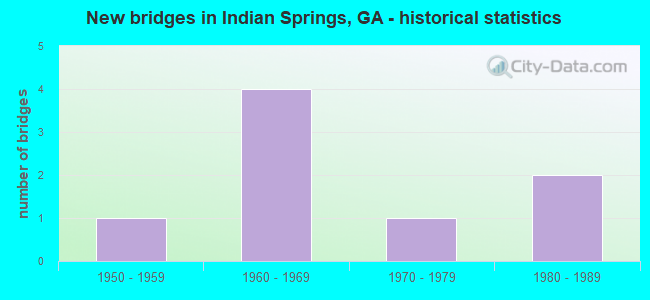
- New bridges - historical statistics
- 11950-1959
- 41960-1969
- 11970-1979
- 21980-1989


- Bridge Condition - Deck
- 87.5%Good
- 12.5%Fair

- Bridge Condition - Superstructure
- 75.0%Good
- 12.5%Satisfactory
- 12.5%Fair

- Bridge Condition - Substructure
- 50.0%Good
- 37.5%Satisfactory
- 12.5%Fair

- Bridge Condition - Channel
- 40.0%Very good
- 20.0%Good
- 40.0%Satisfactory
Find on map >> Show street view
Structure Number: 470014, Location: 3.7 M E OF FT OGLETHORPE (Lat: 34.964339, Lng: -85.176169), Route carried "on" structure: US 41, Year Built: 1955, Status: Open, Structure Length: 8.05m (26.41ft), Average Daily Traffic: 5,750 (year 2011), Truck Traffic: 1%, Average Future Daily Traffic: 8,625 (year 2031), Design Load: H 15, Features Intersected: PEAVINE CREEK
Minimum Vertical Clearance: 30+ m (98+ ft), Kilometerpoint: 19.312, Lanes on structure: 2, Owner: State Highway Agency, Approaching Roadway Width: 8.2m (26.9ft), Material/Design: Steel, Design/Construction: Stringer/Multi-beam, Number Of Spans In Main Unit: 8, Length of Maximum Span: 10.1m (33.1ft), Curb or Sidewalk Widths: Left: 0.7m (2.3ft), Right: 0.7m (2.3ft), Curb-To-Curb Width: 8.4m (27.6ft), Out-to-Out Width: 10.2m (33.5ft)
Condition: Deck: Fair, Superstructure: Fair, Substructure: Fair, Channel: Good, Operating Rating: 38.1 metric tons, Method Used To Determine Operating Rating: Load Factor (LF), Inventory Rating: 22.6 metric tons, Method Used To Determine Inventory Rating: Load Factor (LF), Structural Evaluation: Somewhat better than minimum adequacy, Deck Geometry: High priority of corrective action, Waterway Adequacy: Superior to present desirable criteria, Approach Roadway Alignment: Equal to present desirable criteria, Length Of Structure Improvement: 14.48m (47.51ft), Designated Inspection Frequency: Every 24 months, Inspection Date: January 2022, Bridge Improvement Cost: $1,032,000, Roadway Improvement Cost: $103,000, Total Project Cost: $1,547,000, Deck Structure Type: Concrete Cast-file-Place, Wearing Surface/Protective System: Wearing Surface: Bituminous
Find on map >> Show street view
Structure Number: 470035, Location: 3.9 MI W OF RINGGOLD (Lat: 34.941319, Lng: -85.167039), Route carried "on" structure: Interstate 75, Year Built: 1961, Year Reconstructed: 1988, Status: Open, Structure Length: 4.79m (15.72ft), Average Daily Traffic: 87,100 (year 2011), Truck Traffic: 1%, Average Future Daily Traffic: 130,650 (year 2031), Design Load: HS 20+Mod, Features Intersected: THREE NOTCH ROAD
Minimum Vertical Clearance: 30+ m (98+ ft), Kilometerpoint: 564.880, Lanes on structure: 3, Lanes under structure: 2, Base Highway Network: Yes, Owner: State Highway Agency, Approaching Roadway Width: 17.1m (56.1ft), Skew: 10 degrees, Material/Design: Steel continuous, Design/Construction: Stringer/Multi-beam, Number Of Spans In Main Unit: 3, Length of Maximum Span: 17.4m (57.1ft), Curb-To-Curb Width: 18.3m (60.0ft), Out-to-Out Width: 19.3m (63.3ft)
Condition: Deck: Good, Superstructure: Good, Substructure: Satisfactory, Operating Rating: 54.4 metric tons, Method Used To Determine Operating Rating: Load Factor (LF), Inventory Rating: 32.6 metric tons, Method Used To Determine Inventory Rating: Load Factor (LF), Structural Evaluation: Equal to present minimum criteria, Deck Geometry: High priority of corrective action, Underclear: Equal to present minimum criteria, Approach Roadway Alignment: Equal to present desirable criteria, Designated Inspection Frequency: Every 24 months, Inspection Date: November 2021, Bridge Improvement Cost: $781,000, Roadway Improvement Cost: $78,000, Total Project Cost: $1,171,000, Deck Structure Type: Concrete Cast-file-Place, Wearing Surface/Protective System: Wearing Surface: Epoxy Overlay
Find on map >> Show street view
Structure Number: 470036, Location: 3.9 MI W OF RINGGOLD (Lat: 34.940697, Lng: -85.167469), Route carried "on" structure: Interstate 75, Year Built: 1961, Year Reconstructed: 1988, Status: Open, Structure Length: 5.12m (16.80ft), Average Daily Traffic: 87,100 (year 2011), Truck Traffic: 1%, Average Future Daily Traffic: 130,650 (year 2031), Design Load: HS 20+Mod, Features Intersected: THREE NOTCH ROAD
Minimum Vertical Clearance: 30+ m (98+ ft), Kilometerpoint: 564.880, Lanes on structure: 3, Lanes under structure: 2, Base Highway Network: Yes, Owner: State Highway Agency, Approaching Roadway Width: 18.0m (59.1ft), Skew: 10 degrees, Material/Design: Steel continuous, Design/Construction: Stringer/Multi-beam, Number Of Spans In Main Unit: 3, Length of Maximum Span: 20.1m (65.9ft), Curb-To-Curb Width: 18.3m (60.0ft), Out-to-Out Width: 19.3m (63.3ft)
Condition: Deck: Good, Superstructure: Good, Substructure: Good, Operating Rating: 35.3 metric tons, Method Used To Determine Operating Rating: Load Factor (LF), Inventory Rating: 20.8 metric tons, Method Used To Determine Inventory Rating: Load Factor (LF), Structural Evaluation: Somewhat better than minimum adequacy, Deck Geometry: Better than present minimum criteria, Underclear: Equal to present minimum criteria, Approach Roadway Alignment: Equal to present desirable criteria, Designated Inspection Frequency: Every 24 months, Inspection Date: November 2021, Bridge Improvement Cost: $835,000, Roadway Improvement Cost: $84,000, Total Project Cost: $1,253,000, Deck Structure Type: Concrete Cast-file-Place, Wearing Surface/Protective System: Wearing Surface: Epoxy Overlay
Find on map >> Show street view
Structure Number: 470037, Location: 4.5 MI E OF FT OGLETHORPE (Lat: 34.955064, Lng: -85.179269), Route carried "on" structure: Interstate 75, Year Built: 1961, Year Reconstructed: 1988, Status: Open, Structure Length: 5.97m (19.59ft), Average Daily Traffic: 87,100 (year 2011), Truck Traffic: 1%, Average Future Daily Traffic: 130,650 (year 2031), Design Load: HS 20+Mod, Features Intersected: PEAVINE CREEK
Minimum Vertical Clearance: 30+ m (98+ ft), Kilometerpoint: 568.099, Lanes on structure: 6, Base Highway Network: Yes, Owner: State Highway Agency, Approaching Roadway Width: 31.7m (104.0ft), Skew: 31 degrees, Material/Design: Concrete continuous, Design/Construction: Tee Beam, Number Of Spans In Main Unit: 4, Length of Maximum Span: 16.8m (55.1ft), Curb-To-Curb Width: 40.6m (133.2ft), Out-to-Out Width: 42.4m (139.1ft)
Condition: Deck: Good, Superstructure: Good, Substructure: Good, Channel: Very good, Operating Rating: 48.0 metric tons, Method Used To Determine Operating Rating: Load Factor (LF), Inventory Rating: 29.0 metric tons, Method Used To Determine Inventory Rating: Load Factor (LF), Structural Evaluation: Better than present minimum criteria, Deck Geometry: Superior to present desirable criteria, Waterway Adequacy: Superior to present desirable criteria, Approach Roadway Alignment: Equal to present desirable criteria, Designated Inspection Frequency: Every 24 months, Inspection Date: December 2021, Bridge Improvement Cost: $1,601,000, Roadway Improvement Cost: $160,000, Total Project Cost: $2,402,000, Deck Structure Type: Concrete Cast-file-Place, Wearing Surface/Protective System: Wearing Surface: Epoxy Overlay
Find on map >> Show street view
Structure Number: 470039, Location: 4.2 MI E OF FT OGLETHORPE (Lat: 34.962519, Lng: -85.184378), Route carried "on" structure: Interstate 75, Year Built: 1961, Year Reconstructed: 1988, Status: Open, Structure Length: 8.60m (28.22ft), Average Daily Traffic: 87,100 (year 2011), Truck Traffic: 1%, Average Future Daily Traffic: 130,650 (year 2031), Design Load: HS 20+Mod, Features Intersected: M-1136
Minimum Vertical Clearance: 30+ m (98+ ft), Kilometerpoint: 568.099, Lanes on structure: 6, Lanes under structure: 2, Base Highway Network: Yes, Owner: State Highway Agency, Approaching Roadway Width: 32.9m (107.9ft), Skew: 35 degrees, Material/Design: Steel, Design/Construction: Stringer/Multi-beam, Number Of Spans In Main Unit: 6, Length of Maximum Span: 21.0m (68.9ft), Curb-To-Curb Width: 40.6m (133.2ft), Out-to-Out Width: 42.5m (139.4ft)
Condition: Deck: Good, Superstructure: Good, Substructure: Good, Operating Rating: 32.6 metric tons, Method Used To Determine Operating Rating: Load Factor (LF), Inventory Rating: 19.0 metric tons, Method Used To Determine Inventory Rating: Load Factor (LF), Structural Evaluation: Meets minimum limits, Deck Geometry: Superior to present desirable criteria, Underclear: Meets minimum limits, Approach Roadway Alignment: Equal to present desirable criteria, Designated Inspection Frequency: Every 24 months, Inspection Date: December 2021, Bridge Improvement Cost: $2,304,000, Roadway Improvement Cost: $230,000, Total Project Cost: $3,456,000, Deck Structure Type: Concrete Cast-file-Place, Wearing Surface/Protective System: Wearing Surface: Epoxy Overlay
Find on map >> Show street view
Structure Number: 475002, Location: 5.1 MI NW OF RINGGOLD (Lat: 34.974008, Lng: -85.167828), Route carried "on" structure: County highway 24, Year Built: 1982, Status: Open, Structure Length: 1.58m (5.18ft), Average Daily Traffic: 3,000 (year 2011), Truck Traffic: 1%, Average Future Daily Traffic: 4,500 (year 2031), Features Intersected: PEAVINE CREEK, Facility Carried by Structure: WOOTEN ROAD
Minimum Vertical Clearance: 30+ m (98+ ft), Kilometerpoint: 1.609, Lanes on structure: 2, Owner: County Highway Agency, Approaching Roadway Width: 6.4m (21.0ft), Skew: 1 degrees, Material/Design: Steel, Design/Construction: Stringer/Multi-beam, Number Of Spans In Main Unit: 2, Length of Maximum Span: 7.9m (25.9ft), Curb-To-Curb Width: 7.5m (24.6ft), Out-to-Out Width: 8.5m (27.9ft)
Condition: Deck: Good, Superstructure: Satisfactory, Substructure: Good, Channel: Satisfactory, Operating Rating: 45.3 metric tons, Method Used To Determine Operating Rating: Load Factor (LF), Inventory Rating: 27.2 metric tons, Method Used To Determine Inventory Rating: Load Factor (LF), Structural Evaluation: Equal to present minimum criteria, Deck Geometry: High priority of replacement, Waterway Adequacy: Equal to present desirable criteria, Approach Roadway Alignment: Equal to present desirable criteria, Length Of Structure Improvement: 8.02m (26.31ft), Designated Inspection Frequency: Every 24 months, Inspection Date: January 2022, Bridge Improvement Cost: $203,000, Roadway Improvement Cost: $20,000, Total Project Cost: $305,000, Deck Structure Type: Concrete Cast-file-Place, Wearing Surface/Protective System: Wearing Surface: Bituminous
Find on map >> Show street view
Structure Number: 475022, Location: 3.8 MI N OF RINGGOLD (Lat: 34.971358, Lng: -85.109878), Route carried "on" structure: County highway 692, Year Built: 1974, Status: Posted for load, Structure Length: 1.89m (6.20ft), Average Daily Traffic: 1,000 (year 2011), Truck Traffic: 1%, Average Future Daily Traffic: 1,500 (year 2031), Features Intersected: HURRICANE CREEK, Facility Carried by Structure: SWANSON ROAD
Minimum Vertical Clearance: 30+ m (98+ ft), Kilometerpoint: 3.219, Lanes on structure: 2, Owner: County Highway Agency, Approaching Roadway Width: 6.1m (20.0ft), Skew: 3 degrees, Material/Design: Steel, Design/Construction: Stringer/Multi-beam, Number Of Spans In Main Unit: 3, Length of Maximum Span: 7.9m (25.9ft), Curb or Sidewalk Widths: Left: 0.3m (1.0ft), Right: 0.3m (1.0ft), Curb-To-Curb Width: 7.5m (24.6ft), Out-to-Out Width: 8.7m (28.5ft)
Condition: Deck: Good, Superstructure: Good, Substructure: Satisfactory, Channel: Satisfactory, Operating Rating: 35.3 metric tons, Method Used To Determine Operating Rating: Load Factor (LF), Inventory Rating: 20.8 metric tons, Method Used To Determine Inventory Rating: Load Factor (LF), Structural Evaluation: Somewhat better than minimum adequacy, Deck Geometry: Meets minimum limits, Waterway Adequacy: Meets minimum limits, Approach Roadway Alignment: Equal to present minimum criteria, Bridge Posting: Required (Relationship of Operating Rating to Maximum Legal Load: 0.1 - 9.9% below), Length Of Structure Improvement: 42.12m (138.19ft), Designated Inspection Frequency: Every 24 months, Inspection Date: January 2022, Bridge Improvement Cost: $242,000, Roadway Improvement Cost: $24,000, Total Project Cost: $363,000, Deck Structure Type: Concrete Cast-file-Place
Find on map >> Show street view
Structure Number: 475028, Location: IN GRAYSVILLE (Lat: 34.977289, Lng: -85.144869), Route carried "on" structure: City street 1137, Year Built: 1981, Status: Open, Structure Length: 9.75m (31.99ft), Average Daily Traffic: 4,510 (year 2011), Truck Traffic: 1%, Average Future Daily Traffic: 6,765 (year 2031), Design Load: HS 20+Mod, Features Intersected: SOUTH CHICKAMAUGA CREEK, Facility Carried by Structure: GRAYSVILLE ROAD
Minimum Vertical Clearance: 30+ m (98+ ft), Kilometerpoint: 11.265, Lanes on structure: 2, Owner: County Highway Agency, Approaching Roadway Width: 6.7m (22.0ft), Material/Design: Prestressed concrete, Design/Construction: Box Beam or Girders - Multiple, Number Of Spans In Main Unit: 8, Length of Maximum Span: 12.2m (40.0ft), Curb-To-Curb Width: 13.7m (44.9ft), Out-to-Out Width: 14.8m (48.6ft)
Condition: Deck: Good, Superstructure: Good, Substructure: Satisfactory, Channel: Very good, Operating Rating: 49.8 metric tons, Method Used To Determine Operating Rating: Load Factor (LF), Inventory Rating: 29.9 metric tons, Method Used To Determine Inventory Rating: Load Factor (LF), Structural Evaluation: Equal to present minimum criteria, Deck Geometry: Superior to present desirable criteria, Waterway Adequacy: Superior to present desirable criteria, Approach Roadway Alignment: Equal to present desirable criteria, Designated Inspection Frequency: Every 24 months, Underwater Inspection Frequency: Every 60 months, Inspection Date: January 2022, Underwater Inspection Date: July 2019, Bridge Improvement Cost: $1,250,000, Roadway Improvement Cost: $125,000, Total Project Cost: $1,875,000, Deck Structure Type: Concrete Precast Panels, Wearing Surface/Protective System: Wearing Surface: Bituminous
Find on map >> Show street view
Structure Number: 470035, Location: 3.9 MI W OF RINGGOLD (Lat: 34.941319, Lng: -85.167039), Route carried "under" structure: City street 1137, Structure Length: 0. m, Average Daily Traffic: 4,300 (year 1999), Truck Traffic: 1%, Features Intersected: I-75 NBL, Facility Carried by Structure: I-75 (NBL)
Minimum Vertical Clearance: 9.29m (30.48ft), Kilometerpoint: 4.828, Lanes on structure: 3, Length of Maximum Span: 0.0m
Find on map >> Show street view
Structure Number: 470036, Location: 3.9 MI W OF RINGGOLD (Lat: 34.940697, Lng: -85.167469), Route carried "under" structure: City street 1137, Structure Length: 0. m, Average Daily Traffic: 4,300 (year 1999), Truck Traffic: 1%, Features Intersected: I-75 SBL, Facility Carried by Structure: I-75 (SBL)
Minimum Vertical Clearance: 9.52m (31.23ft), Kilometerpoint: 4.828, Lanes on structure: 3, Length of Maximum Span: 0.0m
Find on map >> Show street view
Structure Number: 470039, Location: 4.2 MI E OF FT OGLETHORPE (Lat: 34.962519, Lng: -85.184378), Route carried "under" structure: City street 1136, Structure Length: 0. m, Average Daily Traffic: 2,370 (year 1999), Truck Traffic: 1%, Features Intersected: I-75, Facility Carried by Structure: I-75
Minimum Vertical Clearance: 4.44m (14.57ft), Kilometerpoint: 3.219, Lanes on structure: 6, Length of Maximum Span: 0.0m