Bridge Statistics for Ingalls, Indiana (IN)
Condition, Traffic, Stress, Structural Evaluation, Project Costs
- National Bridge Inventory (NBI) Statistics
- 21Number of bridges
- 164ft / 49.8mTotal length
- 189,920Total average daily traffic
- 25,766Total average daily truck traffic
- National Bridge Inventory (NBI) Registered Bridges for Ingalls
- No street view available for this location
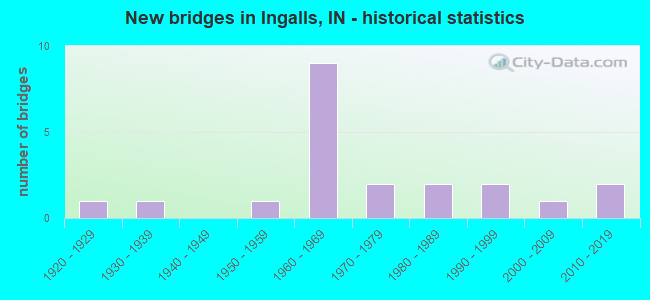
- New bridges - historical statistics
- 11920-1929
- 11930-1939
- 11950-1959
- 91960-1969
- 21970-1979
- 21980-1989
- 21990-1999
- 12000-2009
- 22010-2019

- Reconstructed bridges - Historical Statistics
- 21980-1989
- 01990-1999
- 02000-2009
- 52010-2019
- 12020-2022


- Bridge Condition - Deck
- 20.0%Very good
- 40.0%Good
- 33.3%Satisfactory
- 6.7%Fair

- Bridge Condition - Superstructure
- 20.0%Very good
- 40.0%Good
- 40.0%Satisfactory

- Bridge Condition - Substructure
- 20.0%Very good
- 60.0%Good
- 6.7%Satisfactory
- 13.3%Fair

- Bridge Condition - Channel
- 35.7%Good
- 50.0%Satisfactory
- 14.3%Fair
Find on map >> Show street view
Structure Number: 3337, Location: 00.20 N I-69 (Lat: 39.997331, Lng: -85.843150), Route carried "on" structure: State highway 13, Year Built: 1994, Status: Open, Structure Length: 0.67m (2.20ft), Average Daily Traffic: 3,258 (year 2004), Truck Traffic: 10%, Average Future Daily Traffic: 5,500 (year 2030), Design Load: HS 20, Features Intersected: DRAINAGE DITCH
Minimum Vertical Clearance: 30+ m (98+ ft), Kilometerpoint: 5.906, Lanes on structure: 3, Owner: State Highway Agency, Approaching Roadway Width: 6.7m (22.0ft), Material/Design: Concrete, Design/Construction: Culvert, Number Of Spans In Main Unit: 2, Length of Maximum Span: 3.0m (9.8ft)
Condition: Channel: Good, Culverts: Satisfactory, Operating Rating: 54.5 metric tons, Method Used To Determine Operating Rating: Field evaluation and documented engineering judgment, Inventory Rating: 32.7 metric tons, Method Used To Determine Inventory Rating: Field evaluation and documented engineering judgment, Structural Evaluation: Equal to present minimum criteria, Waterway Adequacy: Better than present minimum criteria, Approach Roadway Alignment: Equal to present desirable criteria, Designated Inspection Frequency: Every 24 months, Inspection Date: December 2020
Find on map >> Show street view
Structure Number: 2413, Location: 02.19 E SR 13 (Lat: 39.952869, Lng: -85.810381), Route carried "on" structure: US 36, Year Built: 1925, Year Reconstructed: 2020, Status: Open, Structure Length: 3.72m (12.20ft), Average Daily Traffic: 10,052 (year 2020), Truck Traffic: 13%, Average Future Daily Traffic: 12,266 (year 2040), Design Load: H 20, Features Intersected: LICK CREEK
Minimum Vertical Clearance: 30+ m (98+ ft), Kilometerpoint: 1.770, Lanes on structure: 2, Owner: State Highway Agency, Approaching Roadway Width: 12.2m (40.0ft), Material/Design: Concrete, Design/Construction: Culvert, Number Of Spans In Main Unit: 1, Length of Maximum Span: 24.4m (80.1ft), Curb-To-Curb Width: 12.5m (41.0ft), Out-to-Out Width: 13.4m (44.0ft)
Condition: Channel: Satisfactory, Culverts: Satisfactory, Operating Rating: 93.7 metric tons, Method Used To Determine Operating Rating: Field evaluation and documented engineering judgment, Inventory Rating: 56.2 metric tons, Method Used To Determine Inventory Rating: Field evaluation and documented engineering judgment, Structural Evaluation: Equal to present minimum criteria, Deck Geometry: Somewhat better than minimum adequacy, Waterway Adequacy: Superior to present desirable criteria, Approach Roadway Alignment: Equal to present desirable criteria, Designated Inspection Frequency: Every 24 months, Inspection Date: May 2021
Find on map >> Show street view
Structure Number: 3903, Location: 00.28 S SR 13 (Lat: 39.993300, Lng: -85.848419), Route carried "on" structure: Interstate 69, Year Built: 1966, Year Reconstructed: 2017, Status: Open, Structure Length: 2.21m (7.25ft), Average Daily Traffic: 28,070 (year 2015), Truck Traffic: 10%, Average Future Daily Traffic: 33,095 (year 2035), Design Load: HS 20+Mod, Features Intersected: THORPE CREEK
Minimum Vertical Clearance: 30+ m (98+ ft), Kilometerpoint: 344.609, Lanes on structure: 3, Base Highway Network: Yes (, Subroute: 1), Owner: State Highway Agency, Approaching Roadway Width: 15.9m (52.2ft), Material/Design: Concrete continuous, Design/Construction: Slab, Number Of Spans In Main Unit: 3, Length of Maximum Span: 8.4m (27.6ft), Curb-To-Curb Width: 20.9m (68.6ft), Out-to-Out Width: 21.8m (71.5ft)
Condition: Deck: Satisfactory, Superstructure: Satisfactory, Substructure: Good, Channel: Satisfactory, Operating Rating: 39.9 metric tons, Method Used To Determine Operating Rating: Load and Resistance Factor Rating (LRFR) rating reported by rating factor(RF) method using HL-93 loadings, Inventory Rating: 30.8 metric tons, Method Used To Determine Inventory Rating: Load and Resistance Factor Rating (LRFR) rating reported by rating factor(RF) method using HL-93 loadings, Structural Evaluation: Equal to present minimum criteria, Deck Geometry: Superior to present desirable criteria, Waterway Adequacy: Superior to present desirable criteria, Approach Roadway Alignment: Equal to present desirable criteria, Designated Inspection Frequency: Every 24 months, Inspection Date: September 2021, Deck Structure Type: Concrete Cast-file-Place, Wearing Surface/Protective System: Wearing Surface: Latex Concrete
Find on map >> Show street view
Structure Number: 3904, Location: 00.28 S SR 13 (Lat: 39.993569, Lng: -85.848489), Route carried "on" structure: Interstate 69, Year Built: 1966, Year Reconstructed: 2017, Status: Open, Structure Length: 2.21m (7.25ft), Average Daily Traffic: 28,070 (year 2015), Truck Traffic: 10%, Average Future Daily Traffic: 33,095 (year 2035), Design Load: HS 20+Mod, Features Intersected: THORPE CREEK
Minimum Vertical Clearance: 30+ m (98+ ft), Kilometerpoint: 344.609, Lanes on structure: 3, Base Highway Network: Yes (, Subroute: 1), Owner: State Highway Agency, Approaching Roadway Width: 15.9m (52.2ft), Material/Design: Concrete continuous, Design/Construction: Slab, Number Of Spans In Main Unit: 3, Length of Maximum Span: 8.4m (27.6ft), Curb-To-Curb Width: 20.9m (68.6ft), Out-to-Out Width: 21.8m (71.5ft)
Condition: Deck: Satisfactory, Superstructure: Satisfactory, Substructure: Good, Channel: Fair, Operating Rating: 42.4 metric tons, Method Used To Determine Operating Rating: Load and Resistance Factor Rating (LRFR) rating reported by rating factor(RF) method using HL-93 loadings, Inventory Rating: 32.7 metric tons, Method Used To Determine Inventory Rating: Load and Resistance Factor Rating (LRFR) rating reported by rating factor(RF) method using HL-93 loadings, Structural Evaluation: Equal to present minimum criteria, Deck Geometry: Superior to present desirable criteria, Waterway Adequacy: Superior to present desirable criteria, Approach Roadway Alignment: Equal to present desirable criteria, Designated Inspection Frequency: Every 24 months, Inspection Date: September 2021, Deck Structure Type: Concrete Cast-file-Place, Wearing Surface/Protective System: Wearing Surface: Latex Concrete
Find on map >> Show street view
Structure Number: 3905, Location: 04.25 S SR 38 (Lat: 39.993650, Lng: -85.843111), Route carried "on" structure: Interstate 69, Year Built: 1966, Year Reconstructed: 2017, Status: Open, Structure Length: 4.54m (14.90ft), Average Daily Traffic: 28,070 (year 2015), Truck Traffic: 10%, Average Future Daily Traffic: 33,095 (year 2035), Design Load: HS 20, Features Intersected: SR 13
Minimum Vertical Clearance: 30+ m (98+ ft), Kilometerpoint: 345.059, Lanes on structure: 3, Lanes under structure: 4, Base Highway Network: Yes (, Subroute: 1), Owner: State Highway Agency, Approaching Roadway Width: 15.9m (52.2ft), Material/Design: Steel continuous, Design/Construction: Stringer/Multi-beam, Number Of Spans In Main Unit: 2, Length of Maximum Span: 22.3m (73.2ft), Curb-To-Curb Width: 17.6m (57.7ft), Out-to-Out Width: 18.5m (60.7ft)
Condition: Deck: Good, Superstructure: Satisfactory, Substructure: Good, Operating Rating: 33.7 metric tons, Method Used To Determine Operating Rating: Load and Resistance Factor Rating (LRFR) rating reported by rating factor(RF) method using HL-93 loadings, Inventory Rating: 23.7 metric tons, Method Used To Determine Inventory Rating: Load and Resistance Factor Rating (LRFR) rating reported by rating factor(RF) method using HL-93 loadings, Structural Evaluation: Somewhat better than minimum adequacy, Deck Geometry: Better than present minimum criteria, Underclear: Somewhat better than minimum adequacy, Approach Roadway Alignment: Equal to present desirable criteria, Designated Inspection Frequency: Every 24 months, Inspection Date: September 2021, Deck Structure Type: Concrete Cast-file-Place, Wearing Surface/Protective System: Wearing Surface: Latex Concrete, Deck Protection: Epoxy Coated Reinforcing
Find on map >> Show street view
Structure Number: 3906, Location: 04.25 S SR 38 (Lat: 39.993881, Lng: -85.843161), Route carried "on" structure: Interstate 69, Year Built: 1966, Year Reconstructed: 2017, Status: Open, Structure Length: 4.54m (14.90ft), Average Daily Traffic: 28,070 (year 2015), Truck Traffic: 10%, Average Future Daily Traffic: 33,095 (year 2035), Design Load: HS 20, Features Intersected: SR 13
Minimum Vertical Clearance: 30+ m (98+ ft), Kilometerpoint: 345.059, Lanes on structure: 3, Lanes under structure: 4, Base Highway Network: Yes (, Subroute: 1), Owner: State Highway Agency, Approaching Roadway Width: 15.9m (52.2ft), Material/Design: Steel continuous, Design/Construction: Stringer/Multi-beam, Number Of Spans In Main Unit: 2, Length of Maximum Span: 22.3m (73.2ft), Curb-To-Curb Width: 17.6m (57.7ft), Out-to-Out Width: 18.5m (60.7ft)
Condition: Deck: Good, Superstructure: Good, Substructure: Good, Operating Rating: 32.4 metric tons, Method Used To Determine Operating Rating: Load and Resistance Factor Rating (LRFR) rating reported by rating factor(RF) method using HL-93 loadings, Inventory Rating: 23.0 metric tons, Method Used To Determine Inventory Rating: Load and Resistance Factor Rating (LRFR) rating reported by rating factor(RF) method using HL-93 loadings, Structural Evaluation: Somewhat better than minimum adequacy, Deck Geometry: Better than present minimum criteria, Underclear: Somewhat better than minimum adequacy, Approach Roadway Alignment: Equal to present desirable criteria, Designated Inspection Frequency: Every 24 months, Inspection Date: September 2021, Deck Structure Type: Concrete Cast-file-Place, Wearing Surface/Protective System: Wearing Surface: Latex Concrete, Deck Protection: Epoxy Coated Reinforcing
Find on map >> Show street view
Structure Number: 3907, Location: 01.74 S SR 38 (Lat: 39.991731, Lng: -85.796161), Route carried "on" structure: Alternate County highway , Year Built: 1966, Year Reconstructed: 2017, Status: Open, Structure Length: 6.20m (20.34ft), Average Daily Traffic: 240 (year 2015), Truck Traffic: 10%, Average Future Daily Traffic: 351 (year 2030), Design Load: HS 20, Features Intersected: I-69 NB/SB, Facility Carried by Structure: CR 650W
Minimum Vertical Clearance: 30+ m (98+ ft), Kilometerpoint: 0.000, Lanes on structure: 2, Lanes under structure: 4, Owner: State Highway Agency, Approaching Roadway Width: 6.1m (20.0ft), Material/Design: Steel continuous, Design/Construction: Stringer/Multi-beam, Number Of Spans In Main Unit: 2, Length of Maximum Span: 30.5m (100.1ft), Curb-To-Curb Width: 7.6m (24.9ft), Out-to-Out Width: 9.0m (29.5ft)
Condition: Deck: Fair, Superstructure: Good, Substructure: Good, Operating Rating: 46.7 metric tons, Method Used To Determine Operating Rating: Load and Resistance Factor Rating (LRFR) rating reported by rating factor(RF) method using HL-93 loadings, Inventory Rating: 36.0 metric tons, Method Used To Determine Inventory Rating: Load and Resistance Factor Rating (LRFR) rating reported by rating factor(RF) method using HL-93 loadings, Structural Evaluation: Better than present minimum criteria, Deck Geometry: Somewhat better than minimum adequacy, Underclear: High priority of corrective action, Approach Roadway Alignment: Equal to present desirable criteria, Designated Inspection Frequency: Every 24 months, Inspection Date: September 2021, Deck Structure Type: Concrete Cast-file-Place, Wearing Surface/Protective System: Wearing Surface: Latex Concrete
Find on map >> Show street view
Structure Number: 3000695, Location: 00.02 N OF E 1000 N (Lat: 39.930100, Lng: -85.782006), Route carried "on" structure: County highway , Year Built: 1989, Status: Open, Structure Length: 0.76m (2.49ft), Average Daily Traffic: 210 (year 2018), Truck Traffic: 3%, Average Future Daily Traffic: 400 (year 2038), Features Intersected: MINGLE DITCH, Facility Carried by Structure: ALFORD RD
Minimum Vertical Clearance: 30+ m (98+ ft), Kilometerpoint: 0.000, Lanes on structure: 2, Owner: County Highway Agency, Approaching Roadway Width: 5.8m (19.0ft), Skew: 3 degrees, Material/Design: Prestressed concrete, Design/Construction: Box Beam or Girders - Multiple, Number Of Spans In Main Unit: 1, Length of Maximum Span: 6.4m (21.0ft), Curb-To-Curb Width: 7.4m (24.3ft), Out-to-Out Width: 7.4m (24.3ft)
Condition: Deck: Very good, Superstructure: Very good, Substructure: Very good, Channel: Good, Operating Rating: 51.4 metric tons, Method Used To Determine Operating Rating: Load and Resistance Factor (LRFR), Inventory Rating: 38.2 metric tons, Method Used To Determine Inventory Rating: Load and Resistance Factor (LRFR), Structural Evaluation: Equal to present desirable criteria, Deck Geometry: Somewhat better than minimum adequacy, Waterway Adequacy: Better than present minimum criteria, Approach Roadway Alignment: High priority of corrective action, Designated Inspection Frequency: Every 24 months, Inspection Date: June 2020, Deck Structure Type: Concrete Precast Panels, Wearing Surface/Protective System: Wearing Surface: Bituminous, Membrane: Preformed Fabric
Find on map >> Show street view
Structure Number: 300073, Location: 00.25 W OF SR 9 (Lat: 39.930031, Lng: -85.786353), Route carried "on" structure: County highway 1000, Year Built: 2011, Status: Open, Structure Length: 0.79m (2.59ft), Average Daily Traffic: 1,090 (year 2018), Truck Traffic: 3%, Average Future Daily Traffic: 2,050 (year 2038), Design Load: HS 20, Features Intersected: MCFADDEN DITCH
Minimum Vertical Clearance: 30+ m (98+ ft), Kilometerpoint: 0.000, Lanes on structure: 2, Owner: County Highway Agency, Approaching Roadway Width: 5.8m (19.0ft), Material/Design: Wood or Timber, Design/Construction: Slab, Number Of Spans In Main Unit: 1, Length of Maximum Span: 7.6m (24.9ft), Curb or Sidewalk Widths: Left: 0.2m (0.7ft), Right: 0.2m (0.7ft), Curb-To-Curb Width: 8.6m (28.2ft), Out-to-Out Width: 9.1m (29.9ft)
Condition: Deck: Very good, Superstructure: Very good, Substructure: Very good, Channel: Satisfactory, Operating Rating: 75.7 metric tons, Method Used To Determine Operating Rating: Load and Resistance Factor (LRFR), Inventory Rating: 56.2 metric tons, Method Used To Determine Inventory Rating: Load and Resistance Factor (LRFR), Structural Evaluation: Equal to present desirable criteria, Deck Geometry: Somewhat better than minimum adequacy, Waterway Adequacy: Equal to present minimum criteria, Approach Roadway Alignment: Equal to present minimum criteria, Designated Inspection Frequency: Every 24 months, Inspection Date: June 2020, Deck Structure Type: Wood or Timber, Wearing Surface/Protective System: Wearing Surface: Bituminous
Find on map >> Show street view
Structure Number: 4800039, Location: 00.65 E SR 13 (Lat: 39.970789, Lng: -85.831397), Route carried "on" structure: County highway , Year Built: 2012, Status: Open, Structure Length: 1.13m (3.71ft), Average Daily Traffic: 190 (year 2016), Truck Traffic: 3%, Average Future Daily Traffic: 270 (year 2036), Features Intersected: UNNAMED DITCH, Facility Carried by Structure: WEST FALL CREEK DR
Minimum Vertical Clearance: 30+ m (98+ ft), Kilometerpoint: 0.000, Lanes on structure: 2, Owner: County Highway Agency, Approaching Roadway Width: 5.2m (17.1ft), Material/Design: Steel, Design/Construction: Stringer/Multi-beam, Number Of Spans In Main Unit: 1, Length of Maximum Span: 10.4m (34.1ft), Curb-To-Curb Width: 10.0m (32.8ft), Out-to-Out Width: 10.0m (32.8ft)
Condition: Deck: Very good, Superstructure: Very good, Substructure: Very good, Channel: Good, Inventory Rating: 63.3 metric tons, Method Used To Determine Inventory Rating: Load Factor (LF), Structural Evaluation: Equal to present desirable criteria, Deck Geometry: Better than present minimum criteria, Waterway Adequacy: Better than present minimum criteria, Approach Roadway Alignment: Equal to present desirable criteria, Designated Inspection Frequency: Every 24 months, Inspection Date: September 2020, Deck Structure Type: Concrete Cast-file-Place, Wearing Surface/Protective System: Wearing Surface: Monolithic Concrete
Find on map >> Show street view
Structure Number: 4800104, Location: 00.50 S FALL CREEK Dr (Lat: 39.970831, Lng: -85.796242), Route carried "on" structure: County highway 25, Year Built: 2002, Status: Open, Structure Length: 5.47m (17.95ft), Average Daily Traffic: 376 (year 2016), Truck Traffic: 4%, Average Future Daily Traffic: 533 (year 2036), Design Load: HS 20, Features Intersected: FALL CREEK, Facility Carried by Structure: CR 650W
Minimum Vertical Clearance: 30+ m (98+ ft), Kilometerpoint: 0.000, Lanes on structure: 2, Owner: County Highway Agency, Approaching Roadway Width: 9.8m (32.2ft), Skew: 1 degrees, Material/Design: Prestressed concrete continuous, Design/Construction: Stringer/Multi-beam, Number Of Spans In Main Unit: 3, Length of Maximum Span: 19.2m (63.0ft), Curb-To-Curb Width: 9.6m (31.5ft), Out-to-Out Width: 10.5m (34.4ft)
Condition: Deck: Good, Superstructure: Good, Substructure: Good, Channel: Good, Operating Rating: 51.6 metric tons, Method Used To Determine Operating Rating: Load Factor (LF), Inventory Rating: 31.0 metric tons, Method Used To Determine Inventory Rating: Load Factor (LF), Structural Evaluation: Better than present minimum criteria, Deck Geometry: Equal to present minimum criteria, Waterway Adequacy: Better than present minimum criteria, Approach Roadway Alignment: Equal to present desirable criteria, Designated Inspection Frequency: Every 24 months, Inspection Date: September 2020, Deck Structure Type: Concrete Cast-file-Place, Wearing Surface/Protective System: Wearing Surface: Monolithic Concrete, Deck Protection: Epoxy Coated Reinforcing
Find on map >> Show street view
Structure Number: 4800106, Location: 00.30 N CR 1100 S (Lat: 39.949261, Lng: -85.782050), Route carried "on" structure: County highway 153, Year Built: 1993, Status: Open, Structure Length: 2.38m (7.81ft), Average Daily Traffic: 154 (year 2016), Truck Traffic: 2%, Average Future Daily Traffic: 219 (year 2036), Design Load: HS 20, Features Intersected: LICK CREEK, Facility Carried by Structure: CR 575W
Minimum Vertical Clearance: 30+ m (98+ ft), Kilometerpoint: 0.000, Lanes on structure: 2, Owner: County Highway Agency, Approaching Roadway Width: 7.9m (25.9ft), Material/Design: Wood or Timber, Design/Construction: Slab, Number Of Spans In Main Unit: 3, Length of Maximum Span: 7.9m (25.9ft), Curb or Sidewalk Widths: Left: 0.2m (0.7ft), Right: 0.2m (0.7ft), Curb-To-Curb Width: 8.0m (26.2ft), Out-to-Out Width: 8.4m (27.6ft)
Condition: Deck: Good, Superstructure: Good, Substructure: Good, Channel: Good, Operating Rating: 80.7 metric tons, Method Used To Determine Operating Rating: Field evaluation and documented engineering judgment, Inventory Rating: 48.3 metric tons, Method Used To Determine Inventory Rating: Field evaluation and documented engineering judgment, Structural Evaluation: Better than present minimum criteria, Deck Geometry: Somewhat better than minimum adequacy, Waterway Adequacy: Equal to present desirable criteria, Approach Roadway Alignment: Equal to present desirable criteria, Designated Inspection Frequency: Every 24 months, Inspection Date: October 2020, Deck Structure Type: Wood or Timber, Wearing Surface/Protective System: Wearing Surface: Bituminous
Find on map >> Show street view
Structure Number: 480011, Location: 01.10 S CR 800 S (Lat: 39.971831, Lng: -85.824211), Route carried "on" structure: County highway 122, Year Built: 1982, Status: Open, Structure Length: 0.73m (2.40ft), Average Daily Traffic: 189 (year 2016), Truck Traffic: 3%, Average Future Daily Traffic: 268 (year 2036), Features Intersected: BRANCH OF FALL CREEK, Facility Carried by Structure: CR 800W
Minimum Vertical Clearance: 30+ m (98+ ft), Kilometerpoint: 0.000, Lanes on structure: 2, Owner: County Highway Agency, Approaching Roadway Width: 7.3m (24.0ft), Skew: 2 degrees, Material/Design: Prestressed concrete, Design/Construction: Box Beam or Girders - Multiple, Number Of Spans In Main Unit: 1, Length of Maximum Span: 7.0m (23.0ft), Curb-To-Curb Width: 6.7m (22.0ft), Out-to-Out Width: 6.8m (22.3ft)
Condition: Deck: Satisfactory, Superstructure: Satisfactory, Substructure: Satisfactory, Channel: Satisfactory, Operating Rating: 54.5 metric tons, Method Used To Determine Operating Rating: Field evaluation and documented engineering judgment, Inventory Rating: 32.7 metric tons, Method Used To Determine Inventory Rating: Field evaluation and documented engineering judgment, Structural Evaluation: Equal to present minimum criteria, Deck Geometry: Meets minimum limits, Waterway Adequacy: Equal to present minimum criteria, Approach Roadway Alignment: Equal to present desirable criteria, Designated Inspection Frequency: Every 24 months, Inspection Date: September 2020, Deck Structure Type: Concrete Precast Panels, Wearing Surface/Protective System: Wearing Surface: Bituminous
Find on map >> Show street view
Structure Number: 4800112, Location: 00.70 S FALL CREEK DR (Lat: 39.964369, Lng: -85.815081), Route carried "on" structure: County highway 17, Year Built: 1954, Year Reconstructed: 1994, Status: Open, Structure Length: 3.47m (11.38ft), Average Daily Traffic: 353 (year 2016), Truck Traffic: 3%, Average Future Daily Traffic: 500 (year 2036), Design Load: HS 20, Features Intersected: FALL CREEK, Facility Carried by Structure: CR 750W
Minimum Vertical Clearance: 30+ m (98+ ft), Kilometerpoint: 0.000, Lanes on structure: 2, Owner: County Highway Agency, Approaching Roadway Width: 6.7m (22.0ft), Material/Design: Steel, Design/Construction: Stringer/Multi-beam, Number Of Spans In Main Unit: 3, Length of Maximum Span: 11.3m (37.1ft), Curb-To-Curb Width: 6.6m (21.7ft), Out-to-Out Width: 6.6m (21.7ft)
Condition: Deck: Satisfactory, Superstructure: Good, Substructure: Fair, Channel: Fair, Operating Rating: 63.3 metric tons, Method Used To Determine Operating Rating: Load Factor (LF), Inventory Rating: 37.9 metric tons, Method Used To Determine Inventory Rating: Load Factor (LF), Structural Evaluation: Somewhat better than minimum adequacy, Deck Geometry: Meets minimum limits, Waterway Adequacy: Equal to present minimum criteria, Approach Roadway Alignment: Equal to present minimum criteria, Designated Inspection Frequency: Every 12 months, Inspection Date: September 2021, Deck Structure Type: Concrete Cast-file-Place, Wearing Surface/Protective System: Wearing Surface: Monolithic Concrete
Find on map >> Show street view
Structure Number: 4800114, Location: 00.30 NE CR 650 W (Lat: 39.978639, Lng: -85.790639), Route carried "on" structure: County highway , Year Built: 1973, Status: Open, Structure Length: 3.09m (10.14ft), Average Daily Traffic: 446 (year 2016), Truck Traffic: 3%, Average Future Daily Traffic: 632 (year 2036), Features Intersected: FOSTER BRANCH CREEK, Facility Carried by Structure: FALL CREEK DRIVE
Minimum Vertical Clearance: 30+ m (98+ ft), Kilometerpoint: 0.000, Lanes on structure: 2, Owner: County Highway Agency, Approaching Roadway Width: 6.4m (21.0ft), Skew: 1 degrees, Material/Design: Concrete continuous, Design/Construction: Slab, Number Of Spans In Main Unit: 3, Length of Maximum Span: 12.1m (39.7ft), Curb-To-Curb Width: 7.9m (25.9ft), Out-to-Out Width: 8.7m (28.5ft)
Condition: Deck: Satisfactory, Superstructure: Satisfactory, Substructure: Good, Channel: Satisfactory, Operating Rating: 54.5 metric tons, Method Used To Determine Operating Rating: Field evaluation and documented engineering judgment, Inventory Rating: 32.7 metric tons, Method Used To Determine Inventory Rating: Field evaluation and documented engineering judgment, Structural Evaluation: Equal to present minimum criteria, Deck Geometry: Somewhat better than minimum adequacy, Waterway Adequacy: Equal to present minimum criteria, Approach Roadway Alignment: Equal to present desirable criteria, Designated Inspection Frequency: Every 24 months, Inspection Date: September 2020, Deck Structure Type: Concrete Cast-file-Place, Wearing Surface/Protective System: Wearing Surface: Monolithic Concrete
Find on map >> Show street view
Structure Number: 4800115, Location: 00.30 N CR 1100 S (Lat: 39.949800, Lng: -85.806019), Route carried "on" structure: County highway 143, Year Built: 1972, Status: Open, Structure Length: 5.12m (16.80ft), Average Daily Traffic: 130 (year 2016), Truck Traffic: 3%, Average Future Daily Traffic: 185 (year 2036), Features Intersected: LICK CREEK, Facility Carried by Structure: CR 700W
Minimum Vertical Clearance: 30+ m (98+ ft), Kilometerpoint: 0.000, Lanes on structure: 2, Owner: County Highway Agency, Approaching Roadway Width: 6.7m (22.0ft), Skew: 4 degrees, Material/Design: Prestressed concrete continuous, Design/Construction: Stringer/Multi-beam, Number Of Spans In Main Unit: 3, Length of Maximum Span: 16.8m (55.1ft), Curb-To-Curb Width: 7.9m (25.9ft), Out-to-Out Width: 8.7m (28.5ft)
Condition: Deck: Good, Superstructure: Good, Substructure: Good, Channel: Satisfactory, Operating Rating: 54.5 metric tons, Method Used To Determine Operating Rating: Field evaluation and documented engineering judgment, Inventory Rating: 32.7 metric tons, Method Used To Determine Inventory Rating: Field evaluation and documented engineering judgment, Structural Evaluation: Better than present minimum criteria, Deck Geometry: Somewhat better than minimum adequacy, Waterway Adequacy: Equal to present desirable criteria, Approach Roadway Alignment: Equal to present minimum criteria, Designated Inspection Frequency: Every 24 months, Inspection Date: October 2020, Deck Structure Type: Concrete Cast-file-Place, Wearing Surface/Protective System: Wearing Surface: Monolithic Concrete
Find on map >> Show street view
Structure Number: 4800117, Location: 00.30 N SR67 / US36 (Lat: 39.952981, Lng: -85.815189), Route carried "on" structure: County highway 17, Year Built: 1935, Year Reconstructed: 1994, Status: Open, Structure Length: 2.73m (8.96ft), Average Daily Traffic: 750 (year 2016), Truck Traffic: 3%, Average Future Daily Traffic: 1,062 (year 2036), Features Intersected: LICK CREEK, Facility Carried by Structure: CR 750W
Minimum Vertical Clearance: 30+ m (98+ ft), Kilometerpoint: 0.000, Lanes on structure: 2, Owner: County Highway Agency, Approaching Roadway Width: 6.4m (21.0ft), Material/Design: Concrete, Design/Construction: Arch - Deck, Number Of Spans In Main Unit: 1, Length of Maximum Span: 24.2m (79.4ft), Curb-To-Curb Width: 7.9m (25.9ft), Out-to-Out Width: 8.8m (28.9ft)
Condition: Deck: Good, Superstructure: Satisfactory, Substructure: Fair, Channel: Satisfactory, Operating Rating: 54.5 metric tons, Method Used To Determine Operating Rating: Field evaluation and documented engineering judgment, Inventory Rating: 32.7 metric tons, Method Used To Determine Inventory Rating: Field evaluation and documented engineering judgment, Structural Evaluation: Somewhat better than minimum adequacy, Deck Geometry: Somewhat better than minimum adequacy, Waterway Adequacy: Better than present minimum criteria, Approach Roadway Alignment: Equal to present desirable criteria, Designated Inspection Frequency: Every 24 months, Inspection Date: October 2020, Deck Structure Type: Concrete Cast-file-Place, Wearing Surface/Protective System: Wearing Surface: Monolithic Concrete
Find on map >> Show street view
Structure Number: 3905, Location: 04.25 S SR 38 (Lat: 39.993650, Lng: -85.843111), Route carried "under" structure: State highway 13, Year Built: 1966, Structure Length: 0. m, Average Daily Traffic: 5,382 (year 2014), Truck Traffic: 12%, Features Intersected: SR 13, Facility Carried by Structure: I-69 NB
Minimum Vertical Clearance: 4.37m (14.34ft), Kilometerpoint: 5.568, Lanes on structure: 2, Lanes under structure: 2, Material/Design: Steel continuous, Design/Construction: Stringer/Multi-beam, Length of Maximum Span: 22.3m (73.2ft)
Find on map >> Show street view
Structure Number: 3906, Location: 04.25 S SR-38 (Lat: 39.993881, Lng: -85.843161), Route carried "under" structure: State highway 13, Year Built: 1966, Structure Length: 0. m, Average Daily Traffic: 4,400 (year 2006), Truck Traffic: 12%, Features Intersected: SR 13, Facility Carried by Structure: I-69 SB
Minimum Vertical Clearance: 4.42m (14.50ft), Kilometerpoint: 5.584, Lanes on structure: 2, Lanes under structure: 2, Material/Design: Steel continuous, Design/Construction: Stringer/Multi-beam, Length of Maximum Span: 22.3m (73.2ft)
Find on map >> Show street view
Structure Number: 3907, Location: 02.51 N of SR 13 (Lat: 39.991731, Lng: -85.796161), Route carried "under" structure: Interstate 69, Year Built: 1966, Structure Length: 0. m, Average Daily Traffic: 25,210 (year 2004), Truck Traffic: 23%, Features Intersected: I69 NBL, Facility Carried by Structure: CR 650W
Minimum Vertical Clearance: 4.90m (16.08ft), Kilometerpoint: 349.099, Lanes on structure: 2, Lanes under structure: 4, Material/Design: Steel continuous, Design/Construction: Stringer/Multi-beam, Length of Maximum Span: 30.5m (100.1ft)
Find on map >> Show street view
Structure Number: 3907, Location: 02.51 N of SR 13 (Lat: 39.991731, Lng: -85.796161), Route carried "under" structure: Interstate 69, Year Built: 1966, Structure Length: 0. m, Average Daily Traffic: 25,210 (year 2004), Truck Traffic: 23%, Features Intersected: I69 SBL, Facility Carried by Structure: CR 650W
Minimum Vertical Clearance: 4.93m (16.17ft), Kilometerpoint: 349.099, Lanes on structure: 2, Lanes under structure: 4, Material/Design: Steel continuous, Design/Construction: Stringer/Multi-beam, Length of Maximum Span: 30.5m (100.1ft)