Bridge Statistics for Islip, New York (NY)
Condition, Traffic, Stress, Structural Evaluation, Project Costs
- National Bridge Inventory (NBI) Statistics
- 10Number of bridges
- 89ft / 26.6mTotal length
- $48,825,000Total costs
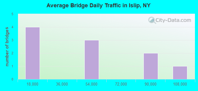
- 459,284Total average daily traffic
- 14,506Total average daily truck traffic
- National Bridge Inventory (NBI) Registered Bridges for Islip
- No street view available for this location
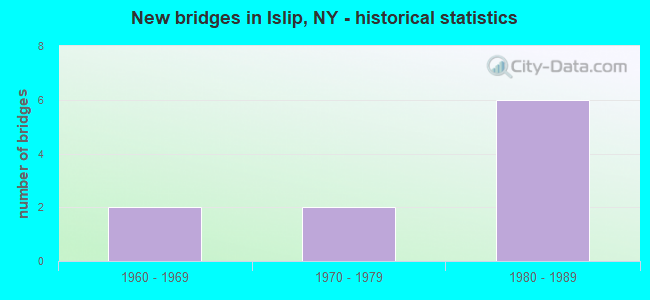
- New bridges - historical statistics
- 21960-1969
- 21970-1979
- 61980-1989
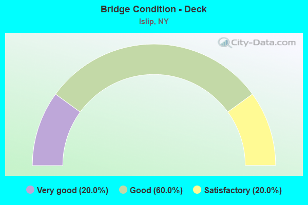
- Bridge Condition - Deck
- 20.0%Very good
- 60.0%Good
- 20.0%Satisfactory
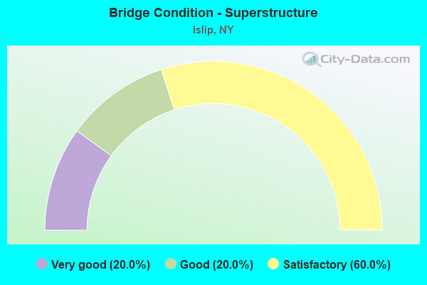
- Bridge Condition - Superstructure
- 20.0%Very good
- 20.0%Good
- 60.0%Satisfactory
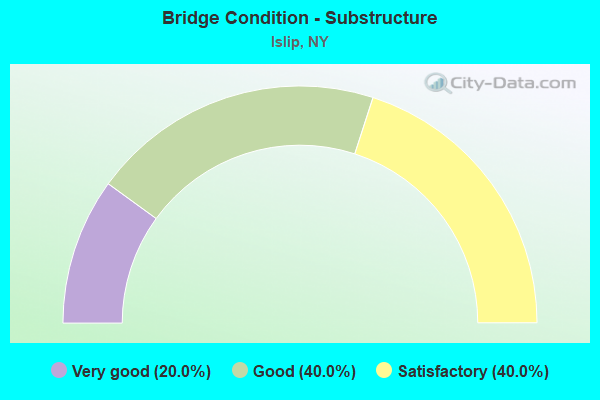
- Bridge Condition - Substructure
- 20.0%Very good
- 40.0%Good
- 40.0%Satisfactory
Find on map >> Show street view
Structure Number: 101925, Location: ISLIP - SH 111 OVER SH 27 (Lat: 40.742236, Lng: -73.207428), Route carried "on" structure: State highway 111, Year Built: 1988, Status: Open, Structure Length: 6.58m (21.59ft), Average Daily Traffic: 14,104 (year 2020), Truck Traffic: 6%, Average Future Daily Traffic: 16,273 (year 2040), Design Load: HS 20, Features Intersected: 27 27 07051124, 27 27
Minimum Vertical Clearance: 30+ m (98+ ft), Kilometerpoint: 1.303, Lanes on structure: 6, Lanes under structure: 10, Base Highway Network: Yes, Owner: State Highway Agency, Approaching Roadway Width: 21.9m (71.9ft), Skew: 20 degrees, Material/Design: Prestressed concrete continuous, Design/Construction: Box Beam or Girders - Multiple, Number Of Spans In Main Unit: 2, Length of Maximum Span: 32.3m (106.0ft), Curb or Sidewalk Widths: Left: 1.5m (4.9ft), Right: 1.5m (4.9ft), Curb-To-Curb Width: 21.9m (71.9ft), Out-to-Out Width: 27.9m (91.5ft)
Condition: Deck: Satisfactory, Superstructure: Satisfactory, Substructure: Good, Operating Rating: 61.9 metric tons, Method Used To Determine Operating Rating: Load and Resistance Factor Rating (LRFR) rating reported by rating factor(RF) method using HL-93 loadings, Inventory Rating: 26.2 metric tons, Method Used To Determine Inventory Rating: Load and Resistance Factor Rating (LRFR) rating reported by rating factor(RF) method using HL-93 loadings, Structural Evaluation: Equal to present minimum criteria, Deck Geometry: High priority of corrective action, Underclear: Somewhat better than minimum adequacy, Approach Roadway Alignment: Equal to present desirable criteria, Length Of Structure Improvement: 6.58m (21.59ft), Designated Inspection Frequency: Every 24 months, Inspection Date: October 2020, Bridge Improvement Cost: $6,379,000, Roadway Improvement Cost: $3,736,000, Total Project Cost: $10,115,000 ( Estimate for 2021), Deck Structure Type: Concrete Cast-file-Place, Wearing Surface/Protective System: Wearing Surface: Integral Concrete, Deck Protection: Epoxy Coated Reinforcing
Find on map >> Show street view
Structure Number: 1037019, Location: JCT RTS 111+HSP (Lat: 40.755486, Lng: -73.209214), Route carried "on" structure: State highway 111, Year Built: 1960, Status: Open, Structure Length: 4.54m (14.90ft), Average Daily Traffic: 14,104 (year 2020), Truck Traffic: 6%, Average Future Daily Traffic: 16,273 (year 2040), Design Load: H 20, Features Intersected: 908M908M07021128, RTE 90
Minimum Vertical Clearance: 30+ m (98+ ft), Kilometerpoint: 2.816, Lanes on structure: 6, Lanes under structure: 8, Base Highway Network: Yes, Owner: State Highway Agency, Approaching Roadway Width: 21.9m (71.9ft), Skew: 21 degrees, Material/Design: Concrete continuous, Design/Construction: Frame, Number Of Spans In Main Unit: 2, Length of Maximum Span: 21.0m (68.9ft), Curb or Sidewalk Widths: Left: 1.5m (4.9ft), Right: 1.5m (4.9ft), Curb-To-Curb Width: 21.9m (71.9ft), Out-to-Out Width: 27.1m (88.9ft)
Condition: Deck: Good, Superstructure: Satisfactory, Substructure: Satisfactory, Operating Rating: 59.8 metric tons, Method Used To Determine Operating Rating: Field evaluation and documented engineering judgment, Inventory Rating: 23.3 metric tons, Method Used To Determine Inventory Rating: Field evaluation and documented engineering judgment, Structural Evaluation: Somewhat better than minimum adequacy, Deck Geometry: High priority of corrective action, Underclear: High priority of corrective action, Approach Roadway Alignment: Equal to present desirable criteria, Length Of Structure Improvement: 4.54m (14.90ft), Designated Inspection Frequency: Every 24 months, Inspection Date: June 2021, Bridge Improvement Cost: $5,633,000, Roadway Improvement Cost: $3,299,000, Total Project Cost: $8,931,000 ( Estimate for 2021), Wearing Surface/Protective System: Wearing Surface: Bituminous, Membrane: Preformed Fabric
Find on map >> Show street view
Structure Number: 105615, Location: 1.6 MI W JCT RTS 27+111 (Lat: 40.737806, Lng: -73.238431), Route carried "on" structure: Other road , Year Built: 1970, Status: Open, Structure Length: 7.62m (25.00ft), Average Daily Traffic: 15,432 (year 2020), Truck Traffic: 3%, Average Future Daily Traffic: 18,746 (year 2040), Design Load: HS 20, Features Intersected: 27 27 07051108 E/B, 27, Facility Carried by Structure: BRENTWOOD ROAD
Minimum Vertical Clearance: 30+ m (98+ ft), Kilometerpoint: 1.239, Lanes on structure: 6, Lanes under structure: 12, Owner: State Highway Agency, Approaching Roadway Width: 23.2m (76.1ft), Material/Design: Steel, Design/Construction: Stringer/Multi-beam, Number Of Spans In Main Unit: 4, Length of Maximum Span: 20.4m (66.9ft), Curb or Sidewalk Widths: Left: 1.6m (5.2ft), Right: 1.6m (5.2ft), Curb-To-Curb Width: 23.2m (76.1ft), Out-to-Out Width: 27.0m (88.6ft)
Condition: Deck: Good, Superstructure: Satisfactory, Substructure: Satisfactory, Operating Rating: 80.7 metric tons, Method Used To Determine Operating Rating: Load Factor (LF), Inventory Rating: 48.1 metric tons, Method Used To Determine Inventory Rating: Load Factor (LF), Structural Evaluation: Equal to present minimum criteria, Deck Geometry: Meets minimum limits, Underclear: High priority of corrective action, Approach Roadway Alignment: Equal to present minimum criteria, Length Of Structure Improvement: 7.62m (25.00ft), Designated Inspection Frequency: Every 24 months, Inspection Date: November 2021, Bridge Improvement Cost: $7,960,000, Roadway Improvement Cost: $4,661,000, Total Project Cost: $12,621,000 ( Estimate for 2021), Deck Structure Type: Concrete Cast-file-Place, Wearing Surface/Protective System: Wearing Surface: Monolithic Concrete
Find on map >> Show street view
Structure Number: 1072679, Location: 1.1 MI W JCT SH 27 & SH 1 (Lat: 40.739203, Lng: -73.228719), Route carried "on" structure: State highway 27, Year Built: 1985, Status: Open, Structure Length: 3.38m (11.09ft), Average Daily Traffic: 88,240 (year 2020), Truck Traffic: 7%, Average Future Daily Traffic: 104,961 (year 2040), Design Load: HS 20, Features Intersected: SAXON AVE
Minimum Vertical Clearance: 30+ m (98+ ft), Kilometerpoint: 18.150, Lanes on structure: 6, Lanes under structure: 5, Base Highway Network: Yes, Owner: State Highway Agency, Approaching Roadway Width: 32.0m (105.0ft), Skew: 20 degrees, Material/Design: Steel, Design/Construction: Stringer/Multi-beam, Number Of Spans In Main Unit: 1, Length of Maximum Span: 32.0m (105.0ft), Curb-To-Curb Width: 32.1m (105.3ft), Out-to-Out Width: 33.9m (111.2ft)
Condition: Deck: Good, Superstructure: Good, Substructure: Good, Operating Rating: 57.0 metric tons, Method Used To Determine Operating Rating: Load and Resistance Factor Rating (LRFR) rating reported by rating factor(RF) method using HL-93 loadings, Inventory Rating: 43.7 metric tons, Method Used To Determine Inventory Rating: Load and Resistance Factor Rating (LRFR) rating reported by rating factor(RF) method using HL-93 loadings, Structural Evaluation: Better than present minimum criteria, Deck Geometry: Superior to present desirable criteria, Underclear: Equal to present minimum criteria, Approach Roadway Alignment: Equal to present desirable criteria, Length Of Structure Improvement: 3.38m (11.09ft), Designated Inspection Frequency: Every 24 months, Inspection Date: July 2020, Bridge Improvement Cost: $4,511,000, Roadway Improvement Cost: $2,641,000, Total Project Cost: $7,152,000 ( Estimate for 2021), Deck Structure Type: Concrete Cast-file-Place, Wearing Surface/Protective System: Wearing Surface: Integral Concrete, Deck Protection: Epoxy Coated Reinforcing
Find on map >> Show street view
Structure Number: 1072689, Location: .4 MI W JCT SH 27 & SH 11 (Lat: 40.741419, Lng: -73.214331), Route carried "on" structure: State highway 27, Year Built: 1985, Status: Open, Structure Length: 4.45m (14.60ft), Average Daily Traffic: 88,240 (year 2020), Truck Traffic: 7%, Average Future Daily Traffic: 104,961 (year 2040), Design Load: HS 20, Features Intersected: COMMACK ROAD
Minimum Vertical Clearance: 30+ m (98+ ft), Kilometerpoint: 19.388, Lanes on structure: 6, Lanes under structure: 4, Base Highway Network: Yes, Owner: State Highway Agency, Approaching Roadway Width: 32.0m (105.0ft), Skew: 24 degrees, Material/Design: Steel, Design/Construction: Stringer/Multi-beam, Number Of Spans In Main Unit: 1, Length of Maximum Span: 42.3m (138.8ft), Curb-To-Curb Width: 32.1m (105.3ft), Out-to-Out Width: 33.9m (111.2ft)
Condition: Deck: Very good, Superstructure: Very good, Substructure: Very good, Operating Rating: 60.6 metric tons, Method Used To Determine Operating Rating: Load and Resistance Factor Rating (LRFR) rating reported by rating factor(RF) method using HL-93 loadings, Inventory Rating: 46.7 metric tons, Method Used To Determine Inventory Rating: Load and Resistance Factor Rating (LRFR) rating reported by rating factor(RF) method using HL-93 loadings, Structural Evaluation: Equal to present desirable criteria, Deck Geometry: Superior to present desirable criteria, Underclear: Equal to present minimum criteria, Approach Roadway Alignment: Equal to present desirable criteria, Length Of Structure Improvement: 4.45m (14.60ft), Designated Inspection Frequency: Every 24 months, Inspection Date: September 2020, Bridge Improvement Cost: $6,311,000, Roadway Improvement Cost: $3,695,000, Total Project Cost: $10,006,000 ( Estimate for 2021), Deck Structure Type: Concrete Cast-file-Place, Wearing Surface/Protective System: Wearing Surface: Integral Concrete, Deck Protection: Epoxy Coated Reinforcing
Find on map >> Show street view
Structure Number: 101925, Location: ISLIP - SH 111 OVER SH 27 (Lat: 40.742236, Lng: -73.207428), Route carried "under" structure: State highway 27, Year Built: 1988, Structure Length: 0. m, Average Daily Traffic: 38,500 (year 1977), Features Intersected: 27 27 07051124, 27 27, Facility Carried by Structure: RTE 111
Minimum Vertical Clearance: 4.75m (15.58ft), Kilometerpoint: 19.903, Lanes on structure: 6, Lanes under structure: 3, Material/Design: Prestressed concrete continuous, Design/Construction: Box Beam or Girders - Multiple, Length of Maximum Span: 32.3m (106.0ft)
Find on map >> Show street view
Structure Number: 1037019, Location: JCT RTS 111+HSP (Lat: 40.755486, Lng: -73.209214), Route carried "under" structure: State highway 908M, Year Built: 1960, Structure Length: 0. m, Average Daily Traffic: 52,164 (year 2002), Features Intersected: 908M908M07021128, RTE 90, Facility Carried by Structure: RTE 111
Minimum Vertical Clearance: 3.84m (12.60ft), Kilometerpoint: 20.113, Lanes on structure: 6, Lanes under structure: 4, Material/Design: Concrete continuous, Design/Construction: Frame, Length of Maximum Span: 21.0m (68.9ft)
Find on map >> Show street view
Structure Number: 105615, Location: 1.6 MI W JCT RTS 27+111 (Lat: 40.737806, Lng: -73.238431), Route carried "under" structure: ServiceState highway 27, Year Built: 1970, Structure Length: 0. m, Average Daily Traffic: 38,500 (year 1977), Features Intersected: 27 27 07051108 E/B, 27, Facility Carried by Structure: BRENTWOOD ROAD
Minimum Vertical Clearance: 4.62m (15.16ft), Kilometerpoint: 17.329, Lanes on structure: 6, Lanes under structure: 3, Material/Design: Steel, Design/Construction: Stringer/Multi-beam, Length of Maximum Span: 20.4m (66.9ft)
Find on map >> Show street view
Structure Number: 1072679, Location: 1.1 MI W JCT SH 27 & SH 1 (Lat: 40.739203, Lng: -73.228719), Route carried "under" structure: City street , Year Built: 1985, Structure Length: 0. m, Average Daily Traffic: 10,000 (year 2021), Features Intersected: SAXON AVE, Facility Carried by Structure: RTE 27
Minimum Vertical Clearance: 4.60m (15.09ft), Kilometerpoint: 0.000, Lanes on structure: 6, Lanes under structure: 5, Material/Design: Steel, Design/Construction: Stringer/Multi-beam, Length of Maximum Span: 32.0m (105.0ft)
Find on map >> Show street view
Structure Number: 1072689, Location: .4 MI W JCT SH 27 & SH 11 (Lat: 40.741419, Lng: -73.214331), Route carried "under" structure: Other road , Year Built: 1985, Structure Length: 0. m, Average Daily Traffic: 100,000 (year 2021), Features Intersected: COMMACK ROAD, Facility Carried by Structure: RTE 27
Minimum Vertical Clearance: 4.54m (14.90ft), Kilometerpoint: 0.000, Lanes on structure: 6, Lanes under structure: 4, Material/Design: Steel, Design/Construction: Stringer/Multi-beam, Length of Maximum Span: 42.3m (138.8ft)