Bridge Statistics for Islip Terrace, New York (NY)
Condition, Traffic, Stress, Structural Evaluation, Project Costs
- National Bridge Inventory (NBI) Statistics
- 12Number of bridges
- 69ft / 21.4mTotal length
- $42,875,000Total costs
- 294,507Total average daily traffic
- 1,641Total average daily truck traffic
- National Bridge Inventory (NBI) Registered Bridges for Islip Terrace
- No street view available for this location
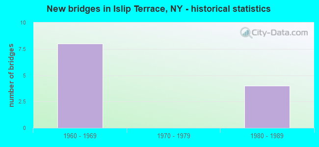
- New bridges - historical statistics
- 81960-1969
- 41980-1989


- Bridge Condition - Deck
- 25.0%Good
- 75.0%Satisfactory

- Bridge Condition - Substructure
- 25.0%Good
- 50.0%Satisfactory
- 25.0%Fair
Find on map >> Show street view
Structure Number: 101926, Location: 0.8 MI E JCT SH 27 & SH 1 (Lat: 40.743186, Lng: -73.193083), Route carried "on" structure: County highway , Year Built: 1988, Status: Open, Structure Length: 6.58m (21.59ft), Average Daily Traffic: 15,375 (year 2018), Truck Traffic: 4%, Average Future Daily Traffic: 18,677 (year 2040), Design Load: HS 20, Features Intersected: 27 27 07051132, 27 27, Facility Carried by Structure: CARLETON AVE
Minimum Vertical Clearance: 30+ m (98+ ft), Kilometerpoint: 1.303, Lanes on structure: 6, Lanes under structure: 10, Owner: State Highway Agency, Approaching Roadway Width: 21.9m (71.9ft), Skew: 20 degrees, Material/Design: Prestressed concrete continuous, Design/Construction: Box Beam or Girders - Multiple, Number Of Spans In Main Unit: 2, Length of Maximum Span: 32.3m (106.0ft), Curb or Sidewalk Widths: Left: 1.5m (4.9ft), Right: 1.5m (4.9ft), Curb-To-Curb Width: 21.9m (71.9ft), Out-to-Out Width: 27.9m (91.5ft)
Condition: Deck: Satisfactory, Superstructure: Satisfactory, Substructure: Good, Operating Rating: 60.3 metric tons, Method Used To Determine Operating Rating: Load and Resistance Factor Rating (LRFR) rating reported by rating factor(RF) method using HL-93 loadings, Inventory Rating: 23.7 metric tons, Method Used To Determine Inventory Rating: Load and Resistance Factor Rating (LRFR) rating reported by rating factor(RF) method using HL-93 loadings, Structural Evaluation: Somewhat better than minimum adequacy, Deck Geometry: High priority of corrective action, Underclear: Somewhat better than minimum adequacy, Approach Roadway Alignment: Equal to present desirable criteria, Length Of Structure Improvement: 6.58m (21.59ft), Designated Inspection Frequency: Every 24 months, Inspection Date: October 2020, Bridge Improvement Cost: $6,323,000, Roadway Improvement Cost: $3,703,000, Total Project Cost: $10,026,000 ( Estimate for 2021), Deck Structure Type: Concrete Cast-file-Place, Wearing Surface/Protective System: Wearing Surface: Integral Concrete, Deck Protection: Epoxy Coated Reinforcing
Find on map >> Show street view
Structure Number: 1059919, Location: 2.5 MI E JCT SH 111 & HSP (Lat: 40.756575, Lng: -73.195475), Route carried "on" structure: County highway , Year Built: 1961, Status: Open, Structure Length: 3.47m (11.38ft), Average Daily Traffic: 19,651 (year 2018), Truck Traffic: 2%, Average Future Daily Traffic: 23,872 (year 2040), Features Intersected: 908M908M07021134 WB, RTE, Facility Carried by Structure: CARLETON AVENUE
Minimum Vertical Clearance: 30+ m (98+ ft), Kilometerpoint: 2.848, Lanes on structure: 4, Lanes under structure: 6, Owner: State Highway Agency, Approaching Roadway Width: 14.6m (47.9ft), Skew: 21 degrees, Material/Design: Concrete continuous, Design/Construction: Frame, Number Of Spans In Main Unit: 2, Length of Maximum Span: 17.4m (57.1ft), Curb or Sidewalk Widths: Left: 1.5m (4.9ft), Right: 1.5m (4.9ft), Curb-To-Curb Width: 14.6m (47.9ft), Out-to-Out Width: 19.8m (65.0ft)
Condition: Deck: Satisfactory, Superstructure: Satisfactory, Substructure: Satisfactory, Operating Rating: 84.7 metric tons, Method Used To Determine Operating Rating: Field evaluation and documented engineering judgment, Inventory Rating: 32.7 metric tons, Method Used To Determine Inventory Rating: Field evaluation and documented engineering judgment, Structural Evaluation: Equal to present minimum criteria, Deck Geometry: High priority of replacement, Underclear: High priority of corrective action, Approach Roadway Alignment: Equal to present desirable criteria, Length Of Structure Improvement: 3.47m (11.38ft), Designated Inspection Frequency: Every 24 months, Inspection Date: May 2021, Bridge Improvement Cost: $3,499,000, Roadway Improvement Cost: $2,049,000, Total Project Cost: $5,549,000 ( Estimate for 2021), Wearing Surface/Protective System: Wearing Surface: Bituminous, Membrane: Preformed Fabric
Find on map >> Show street view
Structure Number: 1059929, Location: 3.2 MI E JCT SH 111 & HSP (Lat: 40.755078, Lng: -73.183786), Route carried "on" structure: City street , Year Built: 1961, Status: Open, Structure Length: 4.69m (15.39ft), Average Daily Traffic: 5,701 (year 2019), Truck Traffic: 4%, Average Future Daily Traffic: 7,053 (year 2040), Design Load: H 20, Features Intersected: 908M908M07021141, E/B, R, Facility Carried by Structure: MANHATTAN BLVD
Minimum Vertical Clearance: 30+ m (98+ ft), Kilometerpoint: 0.949, Lanes on structure: 4, Lanes under structure: 6, Owner: State Highway Agency, Approaching Roadway Width: 14.6m (47.9ft), Skew: 23 degrees, Material/Design: Steel continuous, Design/Construction: Stringer/Multi-beam, Number Of Spans In Main Unit: 2, Length of Maximum Span: 22.9m (75.1ft), Curb or Sidewalk Widths: Left: 1.5m (4.9ft), Right: 1.5m (4.9ft), Curb-To-Curb Width: 14.6m (47.9ft), Out-to-Out Width: 19.6m (64.3ft)
Condition: Deck: Good, Superstructure: Satisfactory, Substructure: Fair, Operating Rating: 53.5 metric tons, Method Used To Determine Operating Rating: Load Factor (LF), Inventory Rating: 31.8 metric tons, Method Used To Determine Inventory Rating: Load Factor (LF), Structural Evaluation: Somewhat better than minimum adequacy, Deck Geometry: High priority of replacement, Underclear: High priority of corrective action, Approach Roadway Alignment: Equal to present desirable criteria, Length Of Structure Improvement: 4.69m (15.39ft), Designated Inspection Frequency: Every 24 months, Inspection Date: July 2021, Bridge Improvement Cost: $4,999,000, Roadway Improvement Cost: $2,927,000, Total Project Cost: $7,926,000 ( Estimate for 2021), Deck Structure Type: Concrete Cast-file-Place, Wearing Surface/Protective System: Wearing Surface: Monolithic Concrete
Find on map >> Show street view
Structure Number: 1059949, Location: JCT SH 27 & SSP (Lat: 40.745900, Lng: -73.178400), Route carried "on" structure: State highway 908M, Year Built: 1960, Status: Open, Structure Length: 6.71m (22.01ft), Average Daily Traffic: 40,595 (year 2020), Truck Traffic: 1%, Average Future Daily Traffic: 48,287 (year 2040), Design Load: H 20, Features Intersected: 27 27 07051140 EB, 27 2
Minimum Vertical Clearance: 30+ m (98+ ft), Kilometerpoint: 23.829, Lanes on structure: 8, Lanes under structure: 12, Base Highway Network: Yes, Owner: State Highway Agency, Approaching Roadway Width: 37.2m (122.0ft), Skew: 20 degrees, Material/Design: Steel, Design/Construction: Stringer/Multi-beam, Number Of Spans In Main Unit: 4, Length of Maximum Span: 16.8m (55.1ft), Curb-To-Curb Width: 37.3m (122.4ft), Out-to-Out Width: 39.4m (129.3ft)
Condition: Deck: Satisfactory, Superstructure: Satisfactory, Substructure: Satisfactory, Operating Rating: 59.9 metric tons, Method Used To Determine Operating Rating: Load Factor (LF), Inventory Rating: 35.4 metric tons, Method Used To Determine Inventory Rating: Load Factor (LF), Structural Evaluation: Equal to present minimum criteria, Deck Geometry: Superior to present desirable criteria, Underclear: High priority of corrective action, Approach Roadway Alignment: Equal to present desirable criteria, Length Of Structure Improvement: 6.70m (21.98ft), Designated Inspection Frequency: Every 24 months, Inspection Date: November 2021, Bridge Improvement Cost: $12,219,000, Roadway Improvement Cost: $7,155,000, Total Project Cost: $19,374,000 ( Estimate for 2021), Deck Structure Type: Concrete Cast-file-Place, Wearing Surface/Protective System: Wearing Surface: Monolithic Concrete
Find on map >> Show street view
Structure Number: 101926, Location: 0.8 MI E JCT SH 27 & SH 1 (Lat: 40.743186, Lng: -73.193083), Route carried "under" structure: State highway 27, Year Built: 1988, Structure Length: 0. m, Average Daily Traffic: 32,900 (year 1978), Features Intersected: 27 27 07051132, 27 27, Facility Carried by Structure: CARLETON AVE
Minimum Vertical Clearance: 4.67m (15.32ft), Kilometerpoint: 21.126, Lanes on structure: 6, Lanes under structure: 3, Material/Design: Prestressed concrete continuous, Design/Construction: Box Beam or Girders - Multiple, Length of Maximum Span: 32.3m (106.0ft)
Find on map >> Show street view
Structure Number: 1059919, Location: 2.5 MI E JCT SH 111 & HSP (Lat: 40.756575, Lng: -73.195475), Route carried "under" structure: State highway 908M, Year Built: 1961, Structure Length: 0. m, Average Daily Traffic: 45,509 (year 2002), Features Intersected: 908M908M07021134 WB, RTE, Facility Carried by Structure: CARLETON AVENUE
Minimum Vertical Clearance: 4.19m (13.75ft), Kilometerpoint: 21.400, Lanes on structure: 4, Lanes under structure: 3, Material/Design: Concrete continuous, Design/Construction: Frame, Length of Maximum Span: 17.4m (57.1ft)
Find on map >> Show street view
Structure Number: 1059929, Location: 3.2 MI E JCT SH 111 & HSP (Lat: 40.755078, Lng: -73.183786), Route carried "under" structure: State highway 908M, Year Built: 1961, Structure Length: 0. m, Average Daily Traffic: 38,888 (year 2002), Features Intersected: 908M908M07021141, E/B, R, Facility Carried by Structure: MANHATTAN BLVD
Minimum Vertical Clearance: 4.04m (13.25ft), Kilometerpoint: 22.462, Lanes on structure: 4, Lanes under structure: 3, Material/Design: Steel continuous, Design/Construction: Stringer/Multi-beam, Length of Maximum Span: 22.9m (75.1ft)
Find on map >> Show street view
Structure Number: 105993, Location: 3.6 MI E JCT SH 111 & HSP (Lat: 40.750269, Lng: -73.180331), Route carried "under" structure: Other road 908M, Year Built: 1969, Structure Length: 0. m, Average Daily Traffic: 38,888 (year 2002), Features Intersected: 908M908M07021145 (EB Roa, Facility Carried by Structure: AT ISLIP TERRACE
Minimum Vertical Clearance: 5.36m (17.59ft), Kilometerpoint: 23.089, Lanes under structure: 3, Material/Design: Steel, Design/Construction: Box Beam or Girders - Single/Spread, Length of Maximum Span: 49.0m (160.8ft)
Find on map >> Show street view
Structure Number: 105993, Location: 3.6 MI E JCT SH 111 & HSP (Lat: 40.750269, Lng: -73.180331), Route carried "under" structure: Other road , Year Built: 1969, Structure Length: 0. m, Features Intersected: 908M908M07021145 (EB Roa, Facility Carried by Structure: AT ISLIP TERRACE
Minimum Vertical Clearance: 5.36m (17.59ft), Kilometerpoint: 23.089, Lanes under structure: 3, Material/Design: Steel, Design/Construction: Box Beam or Girders - Single/Spread, Length of Maximum Span: 49.0m (160.8ft)
Find on map >> Show street view
Structure Number: 1059949, Location: JCT SH 27 & SSP (Lat: 40.745900, Lng: -73.178400), Route carried "under" structure: State highway 27, Year Built: 1960, Structure Length: 0. m, Average Daily Traffic: 25,200 (year 1972), Features Intersected: 27 27 07051140 EB, 27 2, Facility Carried by Structure: RTE 908M
Minimum Vertical Clearance: 4.60m (15.09ft), Kilometerpoint: 22.429, Lanes on structure: 8, Lanes under structure: 3, Material/Design: Steel, Design/Construction: Stringer/Multi-beam, Length of Maximum Span: 16.8m (55.1ft)
Find on map >> Show street view
Structure Number: 107231, Location: .3 MI W JCT SH 27 & HSP (Lat: 40.744331, Lng: -73.183878), Route carried "under" structure: State highway , Year Built: 1983, Structure Length: 0. m, Features Intersected: 27 27 07051136, 27 27, Facility Carried by Structure: WANTAGH AVE PED B
Minimum Vertical Clearance: 5.05m (16.57ft), Kilometerpoint: 21.963, Lanes under structure: 2, Material/Design: Steel, Design/Construction: Stringer/Multi-beam, Length of Maximum Span: 33.5m (109.9ft)
Find on map >> Show street view
Structure Number: 107231, Location: .3 MI W JCT SH 27 & HSP (Lat: 40.744331, Lng: -73.183878), Route carried "under" structure: State highway 27, Year Built: 1983, Structure Length: 0. m, Average Daily Traffic: 31,800 (year 1977), Features Intersected: 27 27 07051136, 27 27, Facility Carried by Structure: WANTAGH AVE PED B
Minimum Vertical Clearance: 5.49m (18.01ft), Kilometerpoint: 21.963, Lanes under structure: 3, Material/Design: Steel, Design/Construction: Stringer/Multi-beam, Length of Maximum Span: 33.5m (109.9ft)