Bridge Statistics for James City, North Carolina (NC)
Condition, Traffic, Stress, Structural Evaluation, Project Costs
- National Bridge Inventory (NBI) Statistics
- 26Number of bridges
- 1,145ft / 349mTotal length
- 405,375Total average daily traffic
- 47,207Total average daily truck traffic
- National Bridge Inventory (NBI) Registered Bridges for James City
- No street view available for this location
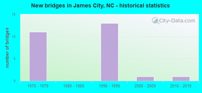
- New bridges - historical statistics
- 111970-1979
- 131990-1999
- 12000-2009
- 12010-2019


- Bridge Condition - Deck
- 63.6%Good
- 36.4%Satisfactory

- Bridge Condition - Substructure
- 9.1%Very good
- 63.6%Good
- 18.2%Satisfactory
- 9.1%Fair

- Bridge Condition - Culverts
- 50.0%Satisfactory
- 50.0%Fair
Find on map >> Show street view
Structure Number: 49006, Location: 0.1MI. N. JCT. SR1004 (Lat: 35.101217, Lng: -77.037108), Route carried "on" structure: Business US 17, Year Built: 2010, Status: Open, Structure Length: 53.70m (176.18ft), Average Daily Traffic: 11,000 (year 2019), Truck Traffic: 12%, Average Future Daily Traffic: 22,000 (year 2040), Design Load: H 10, Features Intersected: TRENT RIVER
Minimum Vertical Clearance: 30.44m (99.87ft), Kilometerpoint: 0.000, Lanes on structure: 2, Base Highway Network: Yes (Inventory Route: 2, Subroute: 70), Owner: State Highway Agency, Approaching Roadway Width: 10.0m (32.8ft), Navigation Control: Yes ( Vertical Clearance: 5.0m (16.4ft), Horizontal Clearance: 30.1m (98.8ft)), Material/Design: Steel, Design/Construction: Movable - Bascule, Number Of Spans In Main Unit: 1, Number Of Approach Spans: 18, Length of Maximum Span: 59.7m (195.9ft), Curb or Sidewalk Widths: Left: 1.6m (5.2ft), Right: 0.0m, Curb-To-Curb Width: 8.5m (27.9ft), Out-to-Out Width: 10.9m (35.8ft)
Condition: Deck: Good, Superstructure: Good, Substructure: Good, Channel: Good, Operating Rating: 89.8 metric tons, Method Used To Determine Operating Rating: Load Factor (LF), Inventory Rating: 56.2 metric tons, Method Used To Determine Inventory Rating: Load Factor (LF), Structural Evaluation: Better than present minimum criteria, Deck Geometry: Meets minimum limits, Waterway Adequacy: Better than present minimum criteria, Approach Roadway Alignment: Equal to present desirable criteria, Designated Inspection Frequency: Every 24 months, Critical Feature Inspection Frequency: Every 24 months, Underwater Inspection Frequency: Every 60 months, Inspection Date: Febuary 2022, Critical Feature Inspection Date: Febuary 2020, Underwater Inspection Date: November 2021, Deck Structure Type: Concrete Cast-file-Place, Wearing Surface/Protective System: Wearing Surface: Other
Find on map >> Show street view
Structure Number: 490085, Location: 2.7 MI.E.JCT.US17 (Lat: 35.094161, Lng: -77.040894), Route carried "on" structure: Bypass US 70, Year Built: 1976, Status: Open, Structure Length: 12.31m (40.39ft), Average Daily Traffic: 26,250 (year 2018), Truck Traffic: 12%, Average Future Daily Traffic: 52,500 (year 2040), Design Load: HS 20+Mod, Features Intersected: SR1004, A&EC RAILROAD
Minimum Vertical Clearance: 5.56m (18.24ft), Kilometerpoint: 127.103, Lanes on structure: 2, Lanes under structure: 2, Base Highway Network: Yes (Inventory Route: 2, Subroute: 70), Owner: State Highway Agency, Approaching Roadway Width: 10.6m (34.8ft), Skew: 19 degrees, Material/Design: Steel, Design/Construction: Stringer/Multi-beam, Number Of Spans In Main Unit: 5, Length of Maximum Span: 37.7m (123.7ft), Curb-To-Curb Width: 12.0m (39.4ft), Out-to-Out Width: 12.8m (42.0ft)
Condition: Deck: Satisfactory, Superstructure: Good, Substructure: Fair, Operating Rating: 82.5 metric tons, Method Used To Determine Operating Rating: Load Factor (LF), Inventory Rating: 48.9 metric tons, Method Used To Determine Inventory Rating: Load Factor (LF), Structural Evaluation: Somewhat better than minimum adequacy, Deck Geometry: Equal to present minimum criteria, Underclear: Meets minimum limits, Approach Roadway Alignment: Equal to present desirable criteria, Designated Inspection Frequency: Every 24 months, Inspection Date: September 2021, Deck Structure Type: Concrete Cast-file-Place, Wearing Surface/Protective System: Wearing Surface: Epoxy Overlay
Find on map >> Show street view
Structure Number: 490086, Location: 2.7 MI. E. JCT.JCT. US17 (Lat: 35.094411, Lng: -77.040694), Route carried "on" structure: Bypass US 70, Year Built: 1976, Status: Open, Structure Length: 10.57m (34.68ft), Average Daily Traffic: 26,250 (year 2018), Truck Traffic: 12%, Average Future Daily Traffic: 52,500 (year 2040), Design Load: HS 20, Features Intersected: SR1004 & ATL&EC RR
Minimum Vertical Clearance: 30+ m (98+ ft), Kilometerpoint: 0.000, Lanes on structure: 3, Lanes under structure: 2, Base Highway Network: Yes (Inventory Route: 2, Subroute: 70), Owner: State Highway Agency, Approaching Roadway Width: 13.4m (44.0ft), Skew: 10 degrees, Material/Design: Steel, Design/Construction: Stringer/Multi-beam, Number Of Spans In Main Unit: 4, Length of Maximum Span: 37.7m (123.7ft), Curb-To-Curb Width: 14.5m (47.6ft), Out-to-Out Width: 15.2m (49.9ft)
Condition: Deck: Satisfactory, Superstructure: Good, Substructure: Good, Operating Rating: 83.4 metric tons, Method Used To Determine Operating Rating: Load Factor (LF), Inventory Rating: 49.8 metric tons, Method Used To Determine Inventory Rating: Load Factor (LF), Structural Evaluation: Better than present minimum criteria, Deck Geometry: Meets minimum limits, Underclear: Meets minimum limits, Approach Roadway Alignment: Equal to present desirable criteria, Designated Inspection Frequency: Every 24 months, Inspection Date: September 2021, Deck Structure Type: Concrete Cast-file-Place, Wearing Surface/Protective System: Wearing Surface: Monolithic Concrete
Find on map >> Show street view
Structure Number: 490087, Location: 1.1MI.E.JCT.SR 1200 (Lat: 35.092803, Lng: -77.038319), Route carried "on" structure: Bypass US 70, Year Built: 1977, Status: Open, Structure Length: 8.10m (26.57ft), Average Daily Traffic: 25,250 (year 2019), Truck Traffic: 12%, Average Future Daily Traffic: 50,500 (year 2040), Design Load: HS 20+Mod, Features Intersected: US17S,US70W BUS
Minimum Vertical Clearance: 30+ m (98+ ft), Kilometerpoint: 0.000, Lanes on structure: 3, Lanes under structure: 4, Base Highway Network: Yes (Inventory Route: 2, Subroute: 70), Owner: State Highway Agency, Approaching Roadway Width: 13.1m (43.0ft), Skew: 4 degrees, Material/Design: Steel, Design/Construction: Stringer/Multi-beam, Number Of Spans In Main Unit: 3, Length of Maximum Span: 44.8m (147.0ft), Curb-To-Curb Width: 14.4m (47.2ft), Out-to-Out Width: 15.2m (49.9ft)
Condition: Deck: Satisfactory, Superstructure: Good, Substructure: Satisfactory, Operating Rating: 80.7 metric tons, Method Used To Determine Operating Rating: Load Factor (LF), Inventory Rating: 48.0 metric tons, Method Used To Determine Inventory Rating: Load Factor (LF), Structural Evaluation: Equal to present minimum criteria, Deck Geometry: Meets minimum limits, Underclear: Meets minimum limits, Approach Roadway Alignment: Equal to present desirable criteria, Designated Inspection Frequency: Every 24 months, Inspection Date: September 2021, Deck Structure Type: Concrete Cast-file-Place, Wearing Surface/Protective System: Wearing Surface: Monolithic Concrete
Find on map >> Show street view
Structure Number: 490088, Location: 1.1MI.E. JCT.SR1200 (Lat: 35.093136, Lng: -77.038306), Route carried "on" structure: Bypass US 70, Year Built: 1977, Status: Open, Structure Length: 8.10m (26.57ft), Average Daily Traffic: 23,500 (year 2018), Truck Traffic: 12%, Average Future Daily Traffic: 47,000 (year 2040), Design Load: HS 20+Mod, Features Intersected: US17, US70 BUS
Minimum Vertical Clearance: 30+ m (98+ ft), Kilometerpoint: 0.000, Lanes on structure: 2, Lanes under structure: 4, Base Highway Network: Yes (Inventory Route: 2, Subroute: 70), Owner: State Highway Agency, Approaching Roadway Width: 12.1m (39.7ft), Skew: 14 degrees, Material/Design: Steel, Design/Construction: Stringer/Multi-beam, Number Of Spans In Main Unit: 3, Length of Maximum Span: 44.8m (147.0ft), Curb-To-Curb Width: 11.9m (39.0ft), Out-to-Out Width: 12.8m (42.0ft)
Condition: Deck: Satisfactory, Superstructure: Good, Substructure: Satisfactory, Operating Rating: 81.6 metric tons, Method Used To Determine Operating Rating: Load Factor (LF), Inventory Rating: 48.9 metric tons, Method Used To Determine Inventory Rating: Load Factor (LF), Structural Evaluation: Equal to present minimum criteria, Deck Geometry: Equal to present minimum criteria, Underclear: High priority of corrective action, Approach Roadway Alignment: Equal to present desirable criteria, Designated Inspection Frequency: Every 24 months, Inspection Date: September 2021, Deck Structure Type: Concrete Cast-file-Place, Wearing Surface/Protective System: Wearing Surface: Epoxy Overlay, Deck Protection: Epoxy Coated Reinforcing
Find on map >> Show street view
Structure Number: 490089, Location: 2.8 MI. E. JCT. US17 (Lat: 35.091619, Lng: -77.037211), Route carried "on" structure: US 70, Year Built: 1975, Status: Open, Structure Length: 0.76m (2.49ft), Average Daily Traffic: 50,500 (year 2019), Truck Traffic: 12%, Average Future Daily Traffic: 101,000 (year 2040), Design Load: HS 20+Mod, Features Intersected: SCOTTS CREEK
Minimum Vertical Clearance: 30+ m (98+ ft), Kilometerpoint: 0.000, Lanes on structure: 8, Base Highway Network: Yes (Inventory Route: 2, Subroute: 70), Owner: State Highway Agency, Approaching Roadway Width: 45.1m (148.0ft), Skew: 20 degrees, Material/Design: Concrete continuous, Design/Construction: Culvert, Number Of Spans In Main Unit: 3, Length of Maximum Span: 2.4m (7.9ft)
Condition: Channel: Good, Culverts: Fair, Operating Rating: 41.7 metric tons, Method Used To Determine Operating Rating: Field evaluation and documented engineering judgment, Inventory Rating: 32.6 metric tons, Method Used To Determine Inventory Rating: Field evaluation and documented engineering judgment, Structural Evaluation: Somewhat better than minimum adequacy, Waterway Adequacy: Better than present minimum criteria, Approach Roadway Alignment: Equal to present desirable criteria, Designated Inspection Frequency: Every 24 months, Underwater Inspection Frequency: Every 60 months, Inspection Date: September 2021, Underwater Inspection Date: September 2021
Find on map >> Show street view
Structure Number: 490221, Location: 0.15 MI.S.JCT.SR1004 (Lat: 35.094514, Lng: -77.037967), Route carried "on" structure: Business US 70, Year Built: 1998, Status: Open, Structure Length: 5.33m (17.49ft), Average Daily Traffic: 5,500 (year 2019), Truck Traffic: 12%, Average Future Daily Traffic: 11,000 (year 2040), Design Load: HS 20+Mod, Features Intersected: US70 RAMP
Minimum Vertical Clearance: 5.85m (19.19ft), Kilometerpoint: 0.000, Lanes on structure: 2, Lanes under structure: 2, Base Highway Network: Yes (Inventory Route: 2, Subroute: 70), Owner: State Highway Agency, Approaching Roadway Width: 11.2m (36.7ft), Skew: 4 degrees, Material/Design: Steel, Design/Construction: Stringer/Multi-beam, Number Of Spans In Main Unit: 1, Length of Maximum Span: 50.5m (165.7ft), Curb-To-Curb Width: 11.3m (37.1ft), Out-to-Out Width: 12.3m (40.4ft)
Condition: Deck: Good, Superstructure: Good, Substructure: Very good, Operating Rating: 89.8 metric tons, Method Used To Determine Operating Rating: Load Factor (LF), Inventory Rating: 58.9 metric tons, Method Used To Determine Inventory Rating: Load Factor (LF), Structural Evaluation: Better than present minimum criteria, Deck Geometry: Somewhat better than minimum adequacy, Underclear: Superior to present desirable criteria, Approach Roadway Alignment: Equal to present desirable criteria, Designated Inspection Frequency: Every 24 months, Inspection Date: September 2021, Deck Structure Type: Concrete Cast-file-Place, Wearing Surface/Protective System: Wearing Surface: Monolithic Concrete, Deck Protection: Epoxy Coated Reinforcing
Find on map >> Show street view
Structure Number: 490232, Location: @ JCT. US70 (Lat: 35.094747, Lng: -77.038431), Route carried "on" structure: Ramp US 17, Year Built: 1999, Status: Open, Structure Length: 60.41m (198.20ft), Average Daily Traffic: 13,125 (year 2018), Truck Traffic: 12%, Average Future Daily Traffic: 26,250 (year 2040), Design Load: HS 20+Mod, Features Intersected: US70E RP, 70W BUS, N&S R
Minimum Vertical Clearance: 30+ m (98+ ft), Kilometerpoint: 0.000, Lanes on structure: 2, Lanes under structure: 11, Owner: State Highway Agency, Approaching Roadway Width: 10.3m (33.8ft), Material/Design: Steel continuous, Design/Construction: Stringer/Multi-beam, Number Of Spans In Main Unit: 14, Length of Maximum Span: 52.1m (170.9ft), Curb-To-Curb Width: 10.1m (33.1ft), Out-to-Out Width: 11.1m (36.4ft)
Condition: Deck: Good, Superstructure: Good, Substructure: Good, Channel: Good, Operating Rating: 71.6 metric tons, Method Used To Determine Operating Rating: Load Factor (LF), Inventory Rating: 41.7 metric tons, Method Used To Determine Inventory Rating: Load Factor (LF), Structural Evaluation: Better than present minimum criteria, Deck Geometry: Equal to present minimum criteria, Underclear: High priority of corrective action, Waterway Adequacy: Better than present minimum criteria, Approach Roadway Alignment: Equal to present desirable criteria, Designated Inspection Frequency: Every 24 months, Underwater Inspection Frequency: Every 60 months, Inspection Date: September 2021, Underwater Inspection Date: June 2020, Deck Structure Type: Concrete Cast-file-Place, Wearing Surface/Protective System: Wearing Surface: Monolithic Concrete, Deck Protection: Epoxy Coated Reinforcing
Find on map >> Show street view
Structure Number: 490233, Location: @ JCT US17 & US70BUS. (Lat: 35.093342, Lng: -77.040275), Route carried "on" structure: Ramp US 17, Year Built: 1999, Status: Open, Structure Length: 7.43m (24.38ft), Average Daily Traffic: 2,750 (year 2019), Truck Traffic: 7%, Average Future Daily Traffic: 5,500 (year 2040), Design Load: HS 20+Mod, Features Intersected: NORFOLK & SOUTHERN R/R
Minimum Vertical Clearance: 30+ m (98+ ft), Kilometerpoint: 0.000, Lanes on structure: 1, Owner: State Highway Agency, Approaching Roadway Width: 8.8m (28.9ft), Material/Design: Steel continuous, Design/Construction: Stringer/Multi-beam, Number Of Spans In Main Unit: 2, Length of Maximum Span: 36.8m (120.7ft), Curb-To-Curb Width: 8.3m (27.2ft), Out-to-Out Width: 9.3m (30.5ft)
Condition: Deck: Good, Superstructure: Good, Substructure: Good, Operating Rating: 66.2 metric tons, Method Used To Determine Operating Rating: Load Factor (LF), Inventory Rating: 40.8 metric tons, Method Used To Determine Inventory Rating: Load Factor (LF), Structural Evaluation: Better than present minimum criteria, Deck Geometry: Superior to present desirable criteria, Underclear: Superior to present desirable criteria, Approach Roadway Alignment: Equal to present desirable criteria, Designated Inspection Frequency: Every 24 months, Inspection Date: September 2021, Deck Structure Type: Concrete Cast-file-Place, Wearing Surface/Protective System: Wearing Surface: Monolithic Concrete, Deck Protection: Epoxy Coated Reinforcing
Find on map >> Show street view
Structure Number: 490234, Location: @ JCT. US70BUS & US17 (Lat: 35.093222, Lng: -77.034919), Route carried "on" structure: Business US 70, Year Built: 1999, Status: Open, Structure Length: 38.74m (127.10ft), Average Daily Traffic: 13,125 (year 2018), Truck Traffic: 12%, Average Future Daily Traffic: 26,250 (year 2040), Design Load: HS 20+Mod, Features Intersected: NEUSE R. & SCOTTS
Minimum Vertical Clearance: 30+ m (98+ ft), Kilometerpoint: 0.000, Lanes on structure: 1, Owner: State Highway Agency, Approaching Roadway Width: 9.4m (30.8ft), Material/Design: Steel continuous, Design/Construction: Stringer/Multi-beam, Number Of Spans In Main Unit: 9, Length of Maximum Span: 42.9m (140.7ft), Curb-To-Curb Width: 9.3m (30.5ft), Out-to-Out Width: 10.3m (33.8ft)
Condition: Deck: Good, Superstructure: Good, Substructure: Good, Channel: Good, Operating Rating: 53.5 metric tons, Method Used To Determine Operating Rating: Load Factor (LF), Inventory Rating: 32.6 metric tons, Method Used To Determine Inventory Rating: Load Factor (LF), Structural Evaluation: Better than present minimum criteria, Deck Geometry: Meets minimum limits, Waterway Adequacy: Better than present minimum criteria, Approach Roadway Alignment: Equal to present desirable criteria, Designated Inspection Frequency: Every 24 months, Inspection Date: September 2021, Deck Structure Type: Concrete Cast-file-Place, Wearing Surface/Protective System: Wearing Surface: Monolithic Concrete, Deck Protection: Epoxy Coated Reinforcing
Find on map >> Show street view
Structure Number: 490235, Location: AT NEUSE RIVER & US17B (Lat: 35.093056, Lng: -77.034728), Route carried "on" structure: Ramp US 17, Year Built: 1999, Status: Open, Structure Length: 54.04m (177.30ft), Average Daily Traffic: 13,125 (year 2018), Truck Traffic: 12%, Average Future Daily Traffic: 26,250 (year 2040), Design Load: HS 20+Mod, Features Intersected: NEUSE RIVER & SCO
Minimum Vertical Clearance: 30+ m (98+ ft), Kilometerpoint: 0.000, Lanes on structure: 2, Owner: State Highway Agency, Approaching Roadway Width: 10.9m (35.8ft), Material/Design: Steel continuous, Design/Construction: Stringer/Multi-beam, Number Of Spans In Main Unit: 13, Length of Maximum Span: 41.4m (135.8ft), Curb-To-Curb Width: 10.7m (35.1ft), Out-to-Out Width: 11.6m (38.1ft)
Condition: Deck: Good, Superstructure: Good, Substructure: Good, Channel: Good, Operating Rating: 40.8 metric tons, Method Used To Determine Operating Rating: Load Factor (LF), Inventory Rating: 24.4 metric tons, Method Used To Determine Inventory Rating: Load Factor (LF), Structural Evaluation: Equal to present minimum criteria, Deck Geometry: Better than present minimum criteria, Waterway Adequacy: Better than present minimum criteria, Approach Roadway Alignment: Equal to present desirable criteria, Designated Inspection Frequency: Every 24 months, Underwater Inspection Frequency: Every 60 months, Inspection Date: September 2021, Underwater Inspection Date: June 2020, Deck Structure Type: Concrete Cast-file-Place, Wearing Surface/Protective System: Wearing Surface: Monolithic Concrete, Deck Protection: Epoxy Coated Reinforcing
Find on map >> Show street view
Structure Number: 490236, Location: AT JCT. US17&US70BUS (Lat: 35.097083, Lng: -77.033444), Route carried "on" structure: Ramp US 70, Year Built: 1999, Status: Open, Structure Length: 89.12m (292.39ft), Average Daily Traffic: 13,250 (year 2018), Truck Traffic: 12%, Average Future Daily Traffic: 26,500 (year 2040), Design Load: HS 20+Mod, Features Intersected: NEUSE RIVER
Minimum Vertical Clearance: 7.87m (25.82ft), Kilometerpoint: 0.000, Lanes on structure: 2, Owner: State Highway Agency, Approaching Roadway Width: 11.8m (38.7ft), Navigation Control: Yes ( Vertical Clearance: 20.1m (65.9ft), Horizontal Clearance: 54.8m (179.8ft)), Material/Design: Steel continuous, Design/Construction: Stringer/Multi-beam, Number Of Spans In Main Unit: 22, Length of Maximum Span: 75.8m (248.7ft), Curb-To-Curb Width: 11.5m (37.7ft), Out-to-Out Width: 12.4m (40.7ft)
Condition: Deck: Good, Superstructure: Good, Substructure: Good, Channel: Good, Operating Rating: 51.7 metric tons, Method Used To Determine Operating Rating: Load Factor (LF), Inventory Rating: 30.8 metric tons, Method Used To Determine Inventory Rating: Load Factor (LF), Structural Evaluation: Better than present minimum criteria, Deck Geometry: Superior to present desirable criteria, Waterway Adequacy: Better than present minimum criteria, Approach Roadway Alignment: Equal to present desirable criteria, Designated Inspection Frequency: Every 24 months, Underwater Inspection Frequency: Every 60 months, Inspection Date: September 2021, Underwater Inspection Date: June 2020, Deck Structure Type: Concrete Cast-file-Place, Wearing Surface/Protective System: Wearing Surface: Monolithic Concrete, Deck Protection: Epoxy Coated Reinforcing
Find on map >> Show street view
Structure Number: 1330264, Location: 500 FT. WEST JCT. US17 (Lat: 34.746147, Lng: -77.459903), Route carried "on" structure: Bypass US 17, Year Built: 2006, Status: Open, Structure Length: 0.82m (2.69ft), Average Daily Traffic: 28,000 (year 2018), Truck Traffic: 12%, Average Future Daily Traffic: 56,000 (year 2040), Design Load: HS 20+Mod, Features Intersected: EDWARDS CREEK
Minimum Vertical Clearance: 30+ m (98+ ft), Kilometerpoint: 0.000, Lanes on structure: 1, Owner: State Highway Agency, Approaching Roadway Width: 8.8m (28.9ft), Skew: 5 degrees, Material/Design: Concrete continuous, Design/Construction: Culvert, Number Of Spans In Main Unit: 2, Length of Maximum Span: 2.4m (7.9ft)
Condition: Channel: Good, Culverts: Satisfactory, Operating Rating: 89.8 metric tons, Method Used To Determine Operating Rating: Load and Resistance Factor (LRFR), Inventory Rating: 89.8 metric tons, Method Used To Determine Inventory Rating: Load and Resistance Factor (LRFR), Structural Evaluation: Equal to present minimum criteria, Waterway Adequacy: Better than present minimum criteria, Approach Roadway Alignment: Equal to present desirable criteria, Designated Inspection Frequency: Every 24 months, Inspection Date: December 2021
Find on map >> Show street view
Structure Number: 490085, Location: 2.7 MI.E.JCT.US17 (Lat: 35.094161, Lng: -77.040894), Route carried "under" structure: State highway 1004, Year Built: 1976, Structure Length: 0. m, Average Daily Traffic: 7,000 (year 2019), Truck Traffic: 7%, Features Intersected: US70E
Minimum Vertical Clearance: 9.06m (29.72ft), Kilometerpoint: 0.000, Lanes on structure: 2, Lanes under structure: 2, Material/Design: Steel, Design/Construction: Stringer/Multi-beam, Length of Maximum Span: 37.7m (123.7ft)
Find on map >> Show street view
Structure Number: 490086, Location: 2.7 MI. E. JCT.JCT. US17 (Lat: 35.094411, Lng: -77.040694), Route carried "under" structure: State highway 1004, Year Built: 1976, Structure Length: 0. m, Average Daily Traffic: 7,000 (year 2019), Truck Traffic: 7%, Features Intersected: US70 WBL
Minimum Vertical Clearance: 8.77m (28.77ft), Kilometerpoint: 0.000, Lanes on structure: 3, Lanes under structure: 2, Material/Design: Steel, Design/Construction: Stringer/Multi-beam, Length of Maximum Span: 37.7m (123.7ft)
Find on map >> Show street view
Structure Number: 490087, Location: 1.1MI.E.JCT.SR 1200 (Lat: 35.092803, Lng: -77.038319), Route carried "under" structure: Ramp US 70, Year Built: 1977, Structure Length: 0. m, Average Daily Traffic: 5,500 (year 2019), Truck Traffic: 7%, Features Intersected: US70 EBL
Minimum Vertical Clearance: 5.29m (17.36ft), Kilometerpoint: 0.000, Lanes on structure: 3, Lanes under structure: 3, Material/Design: Steel, Design/Construction: Stringer/Multi-beam, Length of Maximum Span: 44.8m (147.0ft)
Find on map >> Show street view
Structure Number: 490087, Location: 1.1MI.E.JCT.SR 1200 (Lat: 35.092803, Lng: -77.038319), Route carried "under" structure: Ramp US 17, Year Built: 1977, Structure Length: 0. m, Average Daily Traffic: 12,625 (year 2019), Truck Traffic: 12%, Features Intersected: US70 EBL
Minimum Vertical Clearance: 5.03m (16.50ft), Kilometerpoint: 0.000, Lanes on structure: 3, Lanes under structure: 1, Material/Design: Steel, Design/Construction: Stringer/Multi-beam, Length of Maximum Span: 44.8m (147.0ft)
Find on map >> Show street view
Structure Number: 490088, Location: 1.1MI.E. JCT.SR1200 (Lat: 35.093136, Lng: -77.038306), Route carried "under" structure: Ramp US 17, Year Built: 1977, Structure Length: 0. m, Average Daily Traffic: 12,000 (year 2015), Truck Traffic: 12%, Features Intersected: US70W.BYP
Minimum Vertical Clearance: 6.51m (21.36ft), Kilometerpoint: 0.000, Lanes on structure: 2, Lanes under structure: 1, Material/Design: Steel, Design/Construction: Stringer/Multi-beam, Length of Maximum Span: 44.8m (147.0ft)
Find on map >> Show street view
Structure Number: 490088, Location: 1.1MI.E. JCT.SR1200 (Lat: 35.093136, Lng: -77.038306), Route carried "under" structure: Business US 70, Year Built: 1977, Structure Length: 0. m, Average Daily Traffic: 23,500 (year 2018), Truck Traffic: 12%, Features Intersected: US70W.BYP
Minimum Vertical Clearance: 6.37m (20.90ft), Kilometerpoint: 0.000, Lanes on structure: 2, Lanes under structure: 3, Material/Design: Steel, Design/Construction: Stringer/Multi-beam, Length of Maximum Span: 44.8m (147.0ft)
Find on map >> Show street view
Structure Number: 490221, Location: 0.15 MI.S.JCT.SR1004 (Lat: 35.094514, Lng: -77.037967), Route carried "under" structure: Ramp US 70, Year Built: 1998, Structure Length: 0. m, Average Daily Traffic: 12,625 (year 2019), Truck Traffic: 12%, Features Intersected: US70 BUS. WBL
Minimum Vertical Clearance: 6.27m (20.57ft), Kilometerpoint: 0.000, Lanes on structure: 2, Lanes under structure: 2, Material/Design: Steel, Design/Construction: Stringer/Multi-beam, Length of Maximum Span: 50.5m (165.7ft)
Find on map >> Show street view
Structure Number: 490232, Location: @ JCT. US70 (Lat: 35.094747, Lng: -77.038431), Route carried "under" structure: State highway 1004, Year Built: 1999, Structure Length: 0. m, Average Daily Traffic: 6,400 (year 2018), Truck Traffic: 7%, Features Intersected: US17 SBL RAMP
Minimum Vertical Clearance: 11.14m (36.55ft), Kilometerpoint: 0.000, Lanes on structure: 2, Lanes under structure: 2, Material/Design: Steel continuous, Design/Construction: Stringer/Multi-beam, Length of Maximum Span: 52.1m (170.9ft)
Find on map >> Show street view
Structure Number: 490232, Location: @ JCT. US70 (Lat: 35.094747, Lng: -77.038431), Route carried "under" structure: City street , Year Built: 1999, Structure Length: 0. m, Average Daily Traffic: 100 (year 2015), Truck Traffic: 7%, Features Intersected: US17 SBL RAMP, Facility Carried by Structure: TRENT VILLA DRIVE
Minimum Vertical Clearance: 9.62m (31.56ft), Kilometerpoint: 0.000, Lanes on structure: 2, Lanes under structure: 2, Material/Design: Steel continuous, Design/Construction: Stringer/Multi-beam, Length of Maximum Span: 52.1m (170.9ft)
Find on map >> Show street view
Structure Number: 490232, Location: @ JCT. US70 (Lat: 35.094747, Lng: -77.038431), Route carried "under" structure: Business US 70, Year Built: 1999, Structure Length: 0. m, Average Daily Traffic: 11,750 (year 2018), Truck Traffic: 12%, Features Intersected: US17 SBL RAMP
Minimum Vertical Clearance: 5.89m (19.32ft), Kilometerpoint: 0.000, Lanes on structure: 2, Lanes under structure: 2, Material/Design: Steel continuous, Design/Construction: Stringer/Multi-beam, Length of Maximum Span: 52.1m (170.9ft)
Find on map >> Show street view
Structure Number: 490232, Location: @ JCT. US70 (Lat: 35.094747, Lng: -77.038431), Route carried "under" structure: Ramp US 70, Year Built: 1999, Structure Length: 0. m, Average Daily Traffic: 5,500 (year 2017), Truck Traffic: 12%, Features Intersected: US17 SBL RAMP
Minimum Vertical Clearance: 13.76m (45.14ft), Kilometerpoint: 0.000, Lanes on structure: 2, Lanes under structure: 2, Material/Design: Steel continuous, Design/Construction: Stringer/Multi-beam, Length of Maximum Span: 52.1m (170.9ft)
Find on map >> Show street view
Structure Number: 490232, Location: @ JCT. US70 (Lat: 35.094747, Lng: -77.038431), Route carried "under" structure: Bypass US 70, Year Built: 1999, Structure Length: 0. m, Average Daily Traffic: 23,500 (year 2018), Truck Traffic: 12%, Features Intersected: US17 SBL RAMP
Minimum Vertical Clearance: 7.67m (25.16ft), Kilometerpoint: 0.000, Lanes on structure: 2, Lanes under structure: 1, Material/Design: Steel continuous, Design/Construction: Stringer/Multi-beam, Length of Maximum Span: 52.1m (170.9ft)
Find on map >> Show street view
Structure Number: 490232, Location: @ JCT. US70 (Lat: 35.094747, Lng: -77.038431), Route carried "under" structure: Bypass US 70, Year Built: 1999, Structure Length: 0. m, Average Daily Traffic: 26,250 (year 2018), Truck Traffic: 12%, Features Intersected: US17 SBL RAMP
Minimum Vertical Clearance: 12.67m (41.57ft), Kilometerpoint: 0.000, Lanes on structure: 2, Lanes under structure: 2, Material/Design: Steel continuous, Design/Construction: Stringer/Multi-beam, Length of Maximum Span: 52.1m (170.9ft)