Bridge Statistics for Jamesburg, New Jersey (NJ)
Condition, Traffic, Stress, Structural Evaluation, Project Costs
- National Bridge Inventory (NBI) Statistics
- 14Number of bridges
- 135ft / 41.2mTotal length
- $750,000Total costs
- 396,260Total average daily traffic
- 90,377Total average daily truck traffic
- National Bridge Inventory (NBI) Registered Bridges for Jamesburg
- No street view available for this location
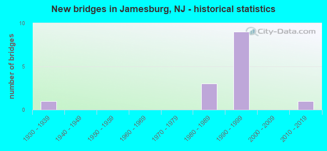
- New bridges - historical statistics
- 11930-1939
- 31980-1989
- 91990-1999
- 12010-2019


- Bridge Condition - Deck
- 75.0%Good
- 12.5%Satisfactory
- 12.5%Fair

- Bridge Condition - Superstructure
- 25.0%Good
- 75.0%Satisfactory

- Bridge Condition - Substructure
- 12.5%Very good
- 50.0%Good
- 25.0%Satisfactory
- 12.5%Fair

- Bridge Condition - Channel
- 28.6%Good
- 71.4%Satisfactory
Find on map >> Show street view
Structure Number: 125B097, Location: 0.5 MI W OF BUCKELEW AVE. (Lat: 40.327081, Lng: -74.419639), Route carried "on" structure: City street , Year Built: 1980, Status: Open, Structure Length: 1.71m (5.61ft), Average Daily Traffic: 1,890 (year 2021), Truck Traffic: 1%, Average Future Daily Traffic: 2,305 (year 2041), Design Load: HS 20, Features Intersected: MANALAPAN BROOK, Facility Carried by Structure: SCHOOLHOUSE ROAD
Minimum Vertical Clearance: 30+ m (98+ ft), Kilometerpoint: 0.000, Lanes on structure: 2, Owner: County Highway Agency, Approaching Roadway Width: 11.0m (36.1ft), Skew: 5 degrees, Material/Design: Prestressed concrete, Design/Construction: Box Beam or Girders - Multiple, Number Of Spans In Main Unit: 1, Length of Maximum Span: 14.9m (48.9ft), Curb or Sidewalk Widths: Left: 1.5m (4.9ft), Right: 1.5m (4.9ft), Curb-To-Curb Width: 12.2m (40.0ft), Out-to-Out Width: 16.0m (52.5ft)
Condition: Deck: Fair, Superstructure: Satisfactory, Substructure: Good, Channel: Satisfactory, Operating Rating: 71.7 metric tons, Method Used To Determine Operating Rating: Load Factor (LF), Inventory Rating: 42.6 metric tons, Method Used To Determine Inventory Rating: Load Factor (LF), Structural Evaluation: Equal to present minimum criteria, Deck Geometry: Better than present minimum criteria, Waterway Adequacy: Better than present minimum criteria, Approach Roadway Alignment: Equal to present desirable criteria, Designated Inspection Frequency: Every 24 months, Inspection Date: March 2021, Deck Structure Type: Concrete Cast-file-Place, Wearing Surface/Protective System: Wearing Surface: Monolithic Concrete, Membrane: Built-up, Deck Protection: Epoxy Coated Reinforcing
Find on map >> Show street view
Structure Number: 125B11, Location: 0.3 MILE EAST OF CR 522 (Lat: 40.345500, Lng: -74.425031), Route carried "on" structure: City street , Year Built: 1995, Status: Open, Structure Length: 0.76m (2.49ft), Average Daily Traffic: 1,420 (year 2021), Truck Traffic: 1%, Average Future Daily Traffic: 1,735 (year 2041), Design Load: HS 20+Mod, Features Intersected: BARCLAY'S BROOK, Facility Carried by Structure: NEW STREET
Minimum Vertical Clearance: 30+ m (98+ ft), Kilometerpoint: 0.000, Lanes on structure: 2, Owner: County Highway Agency, Approaching Roadway Width: 9.4m (30.8ft), Material/Design: Concrete, Design/Construction: Culvert, Number Of Spans In Main Unit: 2, Length of Maximum Span: 3.7m (12.1ft), Curb or Sidewalk Widths: Left: 0.0m, Right: 1.8m (5.9ft), Curb-To-Curb Width: 9.4m (30.8ft), Out-to-Out Width: 12.1m (39.7ft)
Condition: Channel: Satisfactory, Culverts: Satisfactory, Inventory Rating: 70.8 metric tons, Method Used To Determine Inventory Rating: Load Factor (LF), Structural Evaluation: Equal to present minimum criteria, Deck Geometry: Somewhat better than minimum adequacy, Waterway Adequacy: Better than present minimum criteria, Approach Roadway Alignment: Equal to present desirable criteria, Designated Inspection Frequency: Every 24 months, Inspection Date: March 2021, Deck Structure Type: Concrete Cast-file-Place, Wearing Surface/Protective System: Wearing Surface: Monolithic Concrete
Find on map >> Show street view
Structure Number: 125B111, Location: 0.2 MILE NORTH OF CR 522 (Lat: 40.347511, Lng: -74.427419), Route carried "on" structure: City street , Year Built: 1995, Status: Open, Structure Length: 0.88m (2.89ft), Average Daily Traffic: 1,575 (year 2021), Truck Traffic: 1%, Average Future Daily Traffic: 1,925 (year 2041), Design Load: HS 20+Mod, Features Intersected: BARCLAY'S BROOK, Facility Carried by Structure: FORGE STREET
Minimum Vertical Clearance: 30+ m (98+ ft), Kilometerpoint: 0.000, Lanes on structure: 2, Owner: County Highway Agency, Approaching Roadway Width: 8.5m (27.9ft), Skew: 2 degrees, Material/Design: Concrete, Design/Construction: Culvert, Number Of Spans In Main Unit: 2, Length of Maximum Span: 4.0m (13.1ft), Curb or Sidewalk Widths: Left: 0.0m, Right: 1.8m (5.9ft), Curb-To-Curb Width: 8.5m (27.9ft), Out-to-Out Width: 11.2m (36.7ft)
Condition: Channel: Satisfactory, Culverts: Satisfactory, Inventory Rating: 62.6 metric tons, Method Used To Determine Inventory Rating: Load Factor (LF), Structural Evaluation: Equal to present minimum criteria, Deck Geometry: Somewhat better than minimum adequacy, Waterway Adequacy: Better than present minimum criteria, Approach Roadway Alignment: Equal to present desirable criteria, Designated Inspection Frequency: Every 24 months, Inspection Date: March 2021, Deck Structure Type: Concrete Cast-file-Place, Wearing Surface/Protective System: Wearing Surface: Monolithic Concrete, Deck Protection: Epoxy Coated Reinforcing
Find on map >> Show street view
Structure Number: 125B112, Location: 0.2 MI.EAST OF CO.RT.522 (Lat: 40.348369, Lng: -74.429961), Route carried "on" structure: City street , Year Built: 2011, Status: Open, Structure Length: 0.82m (2.69ft), Average Daily Traffic: 883 (year 2021), Truck Traffic: 1%, Average Future Daily Traffic: 1,077 (year 2041), Design Load: HS 25 or greater, Features Intersected: MANALAPAN BROOK, Facility Carried by Structure: LAKE STREET
Minimum Vertical Clearance: 30+ m (98+ ft), Kilometerpoint: 0.000, Lanes on structure: 2, Owner: County Highway Agency, Approaching Roadway Width: 8.8m (28.9ft), Material/Design: Prestressed concrete, Design/Construction: Slab, Number Of Spans In Main Unit: 1, Length of Maximum Span: 7.3m (24.0ft), Curb or Sidewalk Widths: Left: 1.3m (4.3ft), Right: 0.0m, Curb-To-Curb Width: 9.8m (32.2ft), Out-to-Out Width: 11.9m (39.0ft)
Condition: Deck: Good, Superstructure: Good, Substructure: Very good, Channel: Good, Operating Rating: 89.8 metric tons, Method Used To Determine Operating Rating: Load Factor (LF), Inventory Rating: 69.9 metric tons, Method Used To Determine Inventory Rating: Load Factor (LF), Structural Evaluation: Better than present minimum criteria, Deck Geometry: Equal to present minimum criteria, Waterway Adequacy: Better than present minimum criteria, Approach Roadway Alignment: Equal to present desirable criteria, Designated Inspection Frequency: Every 24 months, Inspection Date: June 2021, Deck Structure Type: Concrete Cast-file-Place, Wearing Surface/Protective System: Wearing Surface: Monolithic Concrete, Deck Protection: Epoxy Coated Reinforcing
Find on map >> Show street view
Structure Number: 125B113, Location: 0.1 MI. NE. JCT. CR 522 (Lat: 40.347669, Lng: -74.433389), Route carried "on" structure: County highway 612, Year Built: 1991, Status: Open, Structure Length: 1.13m (3.71ft), Average Daily Traffic: 13,320 (year 2021), Truck Traffic: 4%, Average Future Daily Traffic: 16,250 (year 2041), Design Load: HS 20+Mod, Features Intersected: BARCLAY BROOK
Minimum Vertical Clearance: 30+ m (98+ ft), Kilometerpoint: 3.879, Lanes on structure: 2, Owner: County Highway Agency, Approaching Roadway Width: 12.2m (40.0ft), Skew: 2 degrees, Material/Design: Concrete, Design/Construction: Culvert, Number Of Spans In Main Unit: 2, Length of Maximum Span: 4.9m (16.1ft), Curb or Sidewalk Widths: Left: 1.5m (4.9ft), Right: 1.5m (4.9ft), Curb-To-Curb Width: 12.2m (40.0ft), Out-to-Out Width: 15.9m (52.2ft)
Condition: Channel: Satisfactory, Culverts: Satisfactory, Operating Rating: 81.8 metric tons, Method Used To Determine Operating Rating: Load Factor (LF), Inventory Rating: 49.0 metric tons, Method Used To Determine Inventory Rating: Load Factor (LF), Structural Evaluation: Equal to present minimum criteria, Deck Geometry: Somewhat better than minimum adequacy, Waterway Adequacy: Somewhat better than minimum adequacy, Approach Roadway Alignment: Equal to present desirable criteria, Designated Inspection Frequency: Every 24 months, Inspection Date: March 2021, Deck Structure Type: Concrete Cast-file-Place, Wearing Surface/Protective System: Wearing Surface: Monolithic Concrete, Deck Protection: Epoxy Coated Reinforcing
Find on map >> Show street view
Structure Number: 125B114, Location: FORSGATE & RR AVE JCT (Lat: 40.347489, Lng: -74.434789), Route carried "on" structure: County highway 522, Year Built: 1993, Status: Open, Structure Length: 1.92m (6.30ft), Average Daily Traffic: 8,374 (year 2021), Truck Traffic: 4%, Average Future Daily Traffic: 10,216 (year 2041), Design Load: HS 20+Mod, Features Intersected: MANALAPAN BROOK, Facility Carried by Structure: BUCKELEW AVENUE
Minimum Vertical Clearance: 30+ m (98+ ft), Kilometerpoint: 16.447, Lanes on structure: 4, Owner: County Highway Agency, Approaching Roadway Width: 13.7m (44.9ft), Material/Design: Steel, Design/Construction: Stringer/Multi-beam, Number Of Spans In Main Unit: 1, Length of Maximum Span: 17.7m (58.1ft), Curb or Sidewalk Widths: Left: 1.6m (5.2ft), Right: 2.2m (7.2ft), Curb-To-Curb Width: 13.9m (45.6ft), Out-to-Out Width: 18.4m (60.4ft)
Condition: Deck: Good, Superstructure: Good, Substructure: Good, Channel: Good, Operating Rating: 89.8 metric tons, Method Used To Determine Operating Rating: Load Factor (LF), Inventory Rating: 63.5 metric tons, Method Used To Determine Inventory Rating: Load Factor (LF), Structural Evaluation: Better than present minimum criteria, Deck Geometry: High priority of replacement, Waterway Adequacy: Equal to present desirable criteria, Approach Roadway Alignment: Equal to present desirable criteria, Length Of Structure Improvement: 1.92m (6.30ft), Designated Inspection Frequency: Every 24 months, Inspection Date: June 2021, Bridge Improvement Cost: $126,000, Roadway Improvement Cost: $50,000, Total Project Cost: $220,000 ( Estimate for 2021), Deck Structure Type: Concrete Cast-file-Place, Wearing Surface/Protective System: Wearing Surface: Monolithic Concrete, Deck Protection: Epoxy Coated Reinforcing
Find on map >> Show street view
Structure Number: 125B181, Location: 0.1 MI NORTH OF CO RT 522 (Lat: 40.344531, Lng: -74.421969), Route carried "on" structure: City street , Year Built: 1930, Year Reconstructed: 1960, Status: Open, Structure Length: 0.85m (2.79ft), Average Daily Traffic: 1,470 (year 2021), Truck Traffic: 1%, Average Future Daily Traffic: 1,795 (year 2041), Design Load: HS 20, Features Intersected: BARCLAY'S BROOK, Facility Carried by Structure: STATE STREET
Minimum Vertical Clearance: 30+ m (98+ ft), Kilometerpoint: 0.000, Lanes on structure: 2, Owner: County Highway Agency, Approaching Roadway Width: 9.1m (29.9ft), Skew: 2 degrees, Material/Design: Concrete, Design/Construction: Slab, Number Of Spans In Main Unit: 1, Length of Maximum Span: 7.3m (24.0ft), Curb or Sidewalk Widths: Left: 1.1m (3.6ft), Right: 1.1m (3.6ft), Curb-To-Curb Width: 9.1m (29.9ft), Out-to-Out Width: 11.9m (39.0ft)
Condition: Deck: Satisfactory, Superstructure: Satisfactory, Substructure: Satisfactory, Channel: Satisfactory, Operating Rating: 50.8 metric tons, Method Used To Determine Operating Rating: Field evaluation and documented engineering judgment, Inventory Rating: 30.8 metric tons, Method Used To Determine Inventory Rating: Field evaluation and documented engineering judgment, Structural Evaluation: Equal to present minimum criteria, Deck Geometry: Somewhat better than minimum adequacy, Waterway Adequacy: Equal to present minimum criteria, Approach Roadway Alignment: Equal to present desirable criteria, Designated Inspection Frequency: Every 24 months, Inspection Date: March 2021, Deck Structure Type: Concrete Cast-file-Place, Wearing Surface/Protective System: Wearing Surface: Bituminous
Find on map >> Show street view
Structure Number: M0755, Location: 1.6 MI NORTH OF INT 8A (Lat: 40.373594, Lng: -74.464256), Route carried "on" structure: ServiceInterstate 95, Year Built: 1989, Status: Open, Structure Length: 9.42m (30.91ft), Average Daily Traffic: 241 (year 2019), Truck Traffic: 3%, Average Future Daily Traffic: 294 (year 2039), Design Load: HS 25 or greater, Features Intersected: NJ TPK NSO NSI SNI SNO*, Facility Carried by Structure: NJTPK MI 75 U TURN
Minimum Vertical Clearance: 30+ m (98+ ft), Kilometerpoint: 48.570, Lanes on structure: 2, Lanes under structure: 12, Toll: On toll road, Owner: State Toll Authority, Approaching Roadway Width: 7.9m (25.9ft), Material/Design: Steel continuous, Design/Construction: Stringer/Multi-beam, Number Of Spans In Main Unit: 6, Length of Maximum Span: 20.1m (65.9ft), Curb-To-Curb Width: 8.0m (26.2ft), Out-to-Out Width: 9.1m (29.9ft)
Condition: Deck: Good, Superstructure: Satisfactory, Substructure: Good, Operating Rating: 43.7 metric tons, Method Used To Determine Operating Rating: Load and Resistance Factor Rating (LRFR) rating reported by rating factor(RF) method using HL-93 loadings, Inventory Rating: 33.7 metric tons, Method Used To Determine Inventory Rating: Load and Resistance Factor Rating (LRFR) rating reported by rating factor(RF) method using HL-93 loadings, Structural Evaluation: Equal to present minimum criteria, Deck Geometry: Somewhat better than minimum adequacy, Underclear: High priority of corrective action, Approach Roadway Alignment: Equal to present minimum criteria, Length Of Structure Improvement: 9.42m (30.91ft), Designated Inspection Frequency: Every 24 months, Inspection Date: June 2021, Bridge Improvement Cost: $3,180,000, Roadway Improvement Cost: $106,000, Total Project Cost: $530,000 ( Estimate for 2017), Deck Structure Type: Concrete Cast-file-Place, Wearing Surface/Protective System: Wearing Surface: Latex Concrete, Deck Protection: Epoxy Coated Reinforcing
Find on map >> Show street view
Structure Number: M07552, Location: 1.6 MI NORTH OF INT 8A (Lat: 40.373883, Lng: -74.464106), Route carried "on" structure: County highway 522, Year Built: 1990, Status: Open, Structure Length: 9.72m (31.89ft), Average Daily Traffic: 9,001 (year 2021), Truck Traffic: 5%, Average Future Daily Traffic: 10,983 (year 2041), Design Load: HS 25 or greater, Features Intersected: NJ TPK NSO NSI SNI SNO *
Minimum Vertical Clearance: 30+ m (98+ ft), Kilometerpoint: 10.284, Lanes on structure: 2, Lanes under structure: 12, Owner: State Toll Authority, Approaching Roadway Width: 11.3m (37.1ft), Material/Design: Steel continuous, Design/Construction: Stringer/Multi-beam, Number Of Spans In Main Unit: 6, Length of Maximum Span: 20.1m (65.9ft), Curb or Sidewalk Widths: Left: 1.2m (3.9ft), Right: 0.0m, Curb-To-Curb Width: 9.8m (32.2ft), Out-to-Out Width: 11.9m (39.0ft)
Condition: Deck: Good, Superstructure: Satisfactory, Substructure: Good, Operating Rating: 45.7 metric tons, Method Used To Determine Operating Rating: Load and Resistance Factor Rating (LRFR) rating reported by rating factor(RF) method using HL-93 loadings, Inventory Rating: 35.0 metric tons, Method Used To Determine Inventory Rating: Load and Resistance Factor Rating (LRFR) rating reported by rating factor(RF) method using HL-93 loadings, Structural Evaluation: Equal to present minimum criteria, Deck Geometry: Meets minimum limits, Underclear: Meets minimum limits, Approach Roadway Alignment: Equal to present desirable criteria, Designated Inspection Frequency: Every 24 months, Inspection Date: May 2021, Deck Structure Type: Concrete Cast-file-Place, Wearing Surface/Protective System: Wearing Surface: Latex Concrete, Deck Protection: Epoxy Coated Reinforcing
Find on map >> Show street view
Structure Number: M07558N, Location: 1.6 MI NORTH OF INT 8A (Lat: 40.374294, Lng: -74.463003), Route carried "on" structure: Interstate 95, Year Built: 1990, Status: Open, Structure Length: 3.90m (12.80ft), Average Daily Traffic: 45,116 (year 2021), Truck Traffic: 20%, Average Future Daily Traffic: 55,050 (year 2041), Design Load: HS 25 or greater, Features Intersected: WETLAND, Facility Carried by Structure: NJ TPK SNO ROADWAY
Minimum Vertical Clearance: 30+ m (98+ ft), Kilometerpoint: 48.683, Lanes on structure: 3, Base Highway Network: Yes, Toll: On toll road, Owner: State Toll Authority, Approaching Roadway Width: 13.1m (43.0ft), Material/Design: Steel continuous, Design/Construction: Stringer/Multi-beam, Number Of Spans In Main Unit: 3, Length of Maximum Span: 12.5m (41.0ft), Curb-To-Curb Width: 17.0m (55.8ft), Out-to-Out Width: 17.3m (56.8ft)
Condition: Deck: Good, Superstructure: Satisfactory, Substructure: Fair, Operating Rating: 43.4 metric tons, Method Used To Determine Operating Rating: Load and Resistance Factor Rating (LRFR) rating reported by rating factor(RF) method using HL-93 loadings, Inventory Rating: 33.4 metric tons, Method Used To Determine Inventory Rating: Load and Resistance Factor Rating (LRFR) rating reported by rating factor(RF) method using HL-93 loadings, Structural Evaluation: Somewhat better than minimum adequacy, Deck Geometry: Equal to present minimum criteria, Approach Roadway Alignment: Equal to present desirable criteria, Designated Inspection Frequency: Every 24 months, Inspection Date: May 2021, Deck Structure Type: Concrete Cast-file-Place, Wearing Surface/Protective System: Wearing Surface: Latex Concrete, Deck Protection: Epoxy Coated Reinforcing
Find on map >> Show street view
Structure Number: M07610R, Location: 2.1 MI NORTH OF INT 8A (Lat: 40.381742, Lng: -74.460864), Route carried "on" structure: County highway 610, Year Built: 1990, Status: Open, Structure Length: 10.12m (33.20ft), Average Daily Traffic: 723 (year 2021), Truck Traffic: 4%, Average Future Daily Traffic: 883 (year 2041), Design Load: HS 25 or greater, Features Intersected: NJ TPK MAINLINE, Facility Carried by Structure: DEANS RHODE HALL R
Minimum Vertical Clearance: 30+ m (98+ ft), Kilometerpoint: 9.914, Lanes on structure: 2, Lanes under structure: 12, Owner: State Toll Authority, Approaching Roadway Width: 9.8m (32.2ft), Skew: 1 degrees, Material/Design: Steel continuous, Design/Construction: Stringer/Multi-beam, Number Of Spans In Main Unit: 6, Length of Maximum Span: 20.7m (67.9ft), Curb or Sidewalk Widths: Left: 0.0m, Right: 1.2m (3.9ft), Curb-To-Curb Width: 9.7m (31.8ft), Out-to-Out Width: 11.9m (39.0ft)
Condition: Deck: Good, Superstructure: Satisfactory, Substructure: Satisfactory, Operating Rating: 42.1 metric tons, Method Used To Determine Operating Rating: Load and Resistance Factor Rating (LRFR) rating reported by rating factor(RF) method using HL-93 loadings, Inventory Rating: 32.4 metric tons, Method Used To Determine Inventory Rating: Load and Resistance Factor Rating (LRFR) rating reported by rating factor(RF) method using HL-93 loadings, Structural Evaluation: Equal to present minimum criteria, Deck Geometry: Equal to present minimum criteria, Underclear: Meets minimum limits, Approach Roadway Alignment: Equal to present desirable criteria, Designated Inspection Frequency: Every 24 months, Inspection Date: May 2021, Deck Structure Type: Concrete Cast-file-Place, Wearing Surface/Protective System: Wearing Surface: Latex Concrete, Deck Protection: Epoxy Coated Reinforcing
Find on map >> Show street view
Structure Number: M0755, Location: 1.6 MI NORTH OF INT 8A (Lat: 40.373594, Lng: -74.464256), Route carried "under" structure: Interstate 95, Year Built: 1989, Structure Length: 0. m, Average Daily Traffic: 174,343 (year 2019), Truck Traffic: 28%, Features Intersected: NJ TPK NSO NSI SNI SNO*, Facility Carried by Structure: NJTPK MI 75 U TURN
Minimum Vertical Clearance: 4.65m (15.26ft), Kilometerpoint: 48.570, Lanes on structure: 2, Lanes under structure: 12, Toll: On toll road, Material/Design: Steel continuous, Design/Construction: Stringer/Multi-beam, Length of Maximum Span: 20.1m (65.9ft)
Find on map >> Show street view
Structure Number: M07552, Location: 1.6 MI NORTH OF INT 8A (Lat: 40.373883, Lng: -74.464106), Route carried "under" structure: Interstate 95, Year Built: 1990, Structure Length: 0. m, Average Daily Traffic: 44,232 (year 2021), Truck Traffic: 28%, Features Intersected: NJ TPK NSO NSI SNI SNO *, Facility Carried by Structure: RIDGE ROAD (CR522)
Minimum Vertical Clearance: 5.03m (16.50ft), Kilometerpoint: 48.602, Lanes on structure: 2, Lanes under structure: 12, Toll: On toll road, Material/Design: Steel continuous, Design/Construction: Stringer/Multi-beam, Length of Maximum Span: 20.1m (65.9ft)
Find on map >> Show street view
Structure Number: M07610R, Location: 2.1 MI NORTH OF INT 8A (Lat: 40.381742, Lng: -74.460864), Route carried "under" structure: Interstate 95, Year Built: 1990, Structure Length: 0. m, Average Daily Traffic: 93,672 (year 2021), Truck Traffic: 20%, Features Intersected: NJ TPK MAINLINE, Facility Carried by Structure: DEANS RHODE HALL R
Minimum Vertical Clearance: 5.13m (16.83ft), Kilometerpoint: 49.487, Lanes on structure: 2, Lanes under structure: 12, Toll: On toll road, Material/Design: Steel continuous, Design/Construction: Stringer/Multi-beam, Length of Maximum Span: 20.7m (67.9ft)