Bridge Statistics for Jamestown, New York (NY)
Condition, Traffic, Stress, Structural Evaluation, Project Costs
- National Bridge Inventory (NBI) Statistics
- 23Number of bridges
- 331ft / 101mTotal length
- $87,688,000Total costs
- 106,953Total average daily traffic
- 2,972Total average daily truck traffic
- National Bridge Inventory (NBI) Registered Bridges for Jamestown
- No street view available for this location
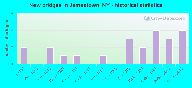
- New bridges - historical statistics
- 2Before 1900
- 21910-1919
- 11920-1929
- 11930-1939
- 11950-1959
- 31970-1979
- 21980-1989
- 41990-1999
- 32000-2009
- 42010-2019
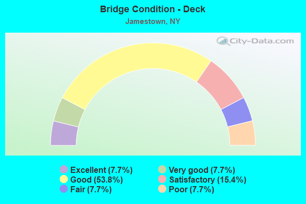
- Bridge Condition - Deck
- 7.7%Excellent
- 7.7%Very good
- 53.8%Good
- 15.4%Satisfactory
- 7.7%Fair
- 7.7%Poor
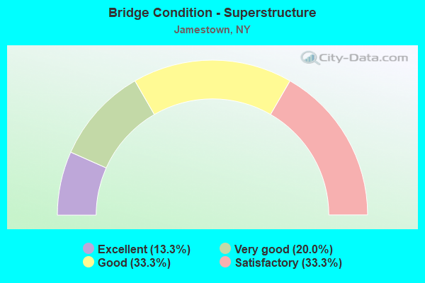
- Bridge Condition - Superstructure
- 13.3%Excellent
- 20.0%Very good
- 33.3%Good
- 33.3%Satisfactory
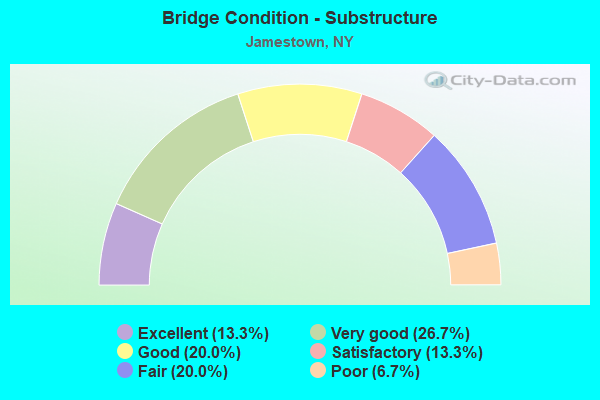
- Bridge Condition - Substructure
- 13.3%Excellent
- 26.7%Very good
- 20.0%Good
- 13.3%Satisfactory
- 20.0%Fair
- 6.7%Poor
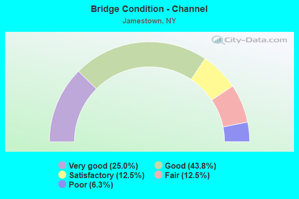
- Bridge Condition - Channel
- 25.0%Very good
- 43.8%Good
- 12.5%Satisfactory
- 12.5%Fair
- 6.3%Poor
Find on map >> Show street view
Structure Number: 102777, Location: 3.9 MI NW JCT US62 & SH62 (Lat: 42.093358, Lng: -79.242589), Route carried "on" structure: State highway 60, Year Built: 2010, Status: Open, Structure Length: 28.83m (94.59ft), Average Daily Traffic: 9,835 (year 2020), Truck Traffic: 4%, Average Future Daily Traffic: 9,881 (year 2040), Design Load: HL 93, Features Intersected: W HARRISON STREET, CHADA
Minimum Vertical Clearance: 30+ m (98+ ft), Kilometerpoint: 6.066, Lanes on structure: 2, Lanes under structure: 3, Base Highway Network: Yes, Owner: State Highway Agency, Approaching Roadway Width: 9.1m (29.9ft), Material/Design: Steel continuous, Design/Construction: Stringer/Multi-beam, Number Of Spans In Main Unit: 6, Length of Maximum Span: 59.5m (195.2ft), Curb or Sidewalk Widths: Left: 3.2m (10.5ft), Right: 0.0m, Curb-To-Curb Width: 9.0m (29.5ft), Out-to-Out Width: 13.2m (43.3ft)
Condition: Deck: Good, Superstructure: Excellent, Substructure: Excellent, Channel: Very good, Operating Rating: 63.5 metric tons, Method Used To Determine Operating Rating: Load and Resistance Factor Rating (LRFR) rating reported by rating factor(RF) method using HL-93 loadings, Inventory Rating: 47.3 metric tons, Method Used To Determine Inventory Rating: Load and Resistance Factor Rating (LRFR) rating reported by rating factor(RF) method using HL-93 loadings, Structural Evaluation: Superior to present desirable criteria, Deck Geometry: Meets minimum limits, Underclear: Equal to present minimum criteria, Waterway Adequacy: Equal to present minimum criteria, Approach Roadway Alignment: Equal to present minimum criteria, Length Of Structure Improvement: 28.83m (94.59ft), Designated Inspection Frequency: Every 24 months, Inspection Date: September 2020, Bridge Improvement Cost: $13,280,000, Roadway Improvement Cost: $7,776,000, Total Project Cost: $21,056,000 ( Estimate for 2021), Deck Structure Type: Concrete Cast-file-Place, Wearing Surface/Protective System: Wearing Surface: Integral Concrete, Deck Protection: Epoxy Coated Reinforcing
Find on map >> Show street view
Structure Number: 201437, Location: .5 MI W JCT SH 394 & SH60 (Lat: 42.097375, Lng: -79.254008), Route carried "on" structure: State highway 394, Year Built: 1990, Status: Open, Structure Length: 13.93m (45.70ft), Average Daily Traffic: 12,805 (year 2020), Truck Traffic: 4%, Average Future Daily Traffic: 12,865 (year 2040), Design Load: HS 20, Features Intersected: LOCAL ACCESS ROAD, CHADA
Minimum Vertical Clearance: 30+ m (98+ ft), Kilometerpoint: 43.974, Lanes on structure: 2, Lanes under structure: 2, Base Highway Network: Yes, Owner: State Highway Agency, Approaching Roadway Width: 11.0m (36.1ft), Material/Design: Steel continuous, Design/Construction: Stringer/Multi-beam, Number Of Spans In Main Unit: 4, Length of Maximum Span: 42.6m (139.8ft), Curb or Sidewalk Widths: Left: 0.0m, Right: 1.7m (5.6ft), Curb-To-Curb Width: 11.0m (36.1ft), Out-to-Out Width: 13.4m (44.0ft)
Condition: Deck: Good, Superstructure: Good, Substructure: Good, Channel: Very good, Operating Rating: 89.8 metric tons, Method Used To Determine Operating Rating: Load Factor (LF), Inventory Rating: 49.9 metric tons, Method Used To Determine Inventory Rating: Load Factor (LF), Structural Evaluation: Better than present minimum criteria, Deck Geometry: Meets minimum limits, Underclear: High priority of corrective action, Waterway Adequacy: Equal to present minimum criteria, Approach Roadway Alignment: Equal to present desirable criteria, Length Of Structure Improvement: 13.92m (45.67ft), Designated Inspection Frequency: Every 24 months, Inspection Date: September 2021, Bridge Improvement Cost: $6,957,000, Roadway Improvement Cost: $4,074,000, Total Project Cost: $11,032,000 ( Estimate for 2021), Deck Structure Type: Concrete Cast-file-Place, Wearing Surface/Protective System: Wearing Surface: Integral Concrete, Deck Protection: Epoxy Coated Reinforcing
Find on map >> Show street view
Structure Number: 225834, Location: CITY OF JAMESTOWN-W.THIRD (Lat: 42.094389, Lng: -79.253231), Route carried "on" structure: County highway 954, Year Built: 1988, Status: Open, Structure Length: 27.92m (91.60ft), Average Daily Traffic: 7,544 (year 2020), Truck Traffic: 2%, Average Future Daily Traffic: 7,966 (year 2040), Design Load: HS 20, Features Intersected: STEELE STREET, CHADAKOIN
Minimum Vertical Clearance: 30+ m (98+ ft), Kilometerpoint: 1.319, Lanes on structure: 2, Lanes under structure: 2, Base Highway Network: Yes, Owner: State Highway Agency, Approaching Roadway Width: 14.0m (45.9ft), Skew: 22 degrees, Material/Design: Steel continuous, Design/Construction: Stringer/Multi-beam, Number Of Spans In Main Unit: 4, Length of Maximum Span: 72.2m (236.9ft), Curb or Sidewalk Widths: Left: 1.5m (4.9ft), Right: 1.5m (4.9ft), Curb-To-Curb Width: 14.0m (45.9ft), Out-to-Out Width: 17.6m (57.7ft)
Condition: Deck: Good, Superstructure: Good, Substructure: Satisfactory, Channel: Good, Operating Rating: 72.6 metric tons, Method Used To Determine Operating Rating: Load Factor (LF), Inventory Rating: 42.6 metric tons, Method Used To Determine Inventory Rating: Load Factor (LF), Structural Evaluation: Equal to present minimum criteria, Deck Geometry: Superior to present desirable criteria, Underclear: Meets minimum limits, Waterway Adequacy: Somewhat better than minimum adequacy, Approach Roadway Alignment: Equal to present desirable criteria, Length Of Structure Improvement: 27.91m (91.57ft), Designated Inspection Frequency: Every 24 months, Inspection Date: June 2021, Bridge Improvement Cost: $17,519,000, Roadway Improvement Cost: $10,259,000, Total Project Cost: $27,778,000 ( Estimate for 2021), Deck Structure Type: Concrete Cast-file-Place, Wearing Surface/Protective System: Wearing Surface: Integral Concrete, Deck Protection: Epoxy Coated Reinforcing
Find on map >> Show street view
Structure Number: 225835, Location: AT JAMESTOWN (Lat: 42.093814, Lng: -79.249164), Route carried "on" structure: City street , Year Built: 2012, Status: Open, Structure Length: 2.53m (8.30ft), Average Daily Traffic: 824 (year 2019), Truck Traffic: 4%, Average Future Daily Traffic: 870 (year 2040), Design Load: HS 25 or greater, Features Intersected: CHADAKOIN RIVER, Facility Carried by Structure: SPRAGUE STREET
Minimum Vertical Clearance: 30+ m (98+ ft), Kilometerpoint: 0.547, Lanes on structure: 2, Owner: County Highway Agency, Approaching Roadway Width: 8.5m (27.9ft), Material/Design: Prestressed concrete, Design/Construction: Box Beam or Girders - Multiple, Number Of Spans In Main Unit: 1, Length of Maximum Span: 24.1m (79.1ft), Curb or Sidewalk Widths: Left: 2.0m (6.6ft), Right: 2.0m (6.6ft), Curb-To-Curb Width: 8.5m (27.9ft), Out-to-Out Width: 13.3m (43.6ft)
Condition: Deck: Good, Superstructure: Very good, Substructure: Good, Channel: Good, Inventory Rating: 68.9 metric tons, Method Used To Determine Inventory Rating: Load Factor (LF), Structural Evaluation: Better than present minimum criteria, Deck Geometry: Somewhat better than minimum adequacy, Waterway Adequacy: Equal to present minimum criteria, Approach Roadway Alignment: Meets minimum limits, Length Of Structure Improvement: 2.52m (8.27ft), Designated Inspection Frequency: Every 24 months, Underwater Inspection Frequency: Every 60 months, Inspection Date: November 2020, Underwater Inspection Date: July 2018, Bridge Improvement Cost: $1,129,000, Roadway Improvement Cost: $661,000, Total Project Cost: $1,791,000 ( Estimate for 2021), Wearing Surface/Protective System: Wearing Surface: Integral Concrete
Find on map >> Show street view
Structure Number: 225836, Location: AT JAMESTOWN (Lat: 42.093989, Lng: -79.240275), Route carried "on" structure: City street , Year Built: 1872, Year Reconstructed: 2018, Status: Open, Structure Length: 2.29m (7.51ft), Average Daily Traffic: 5,115 (year 2019), Truck Traffic: 3%, Average Future Daily Traffic: 5,401 (year 2040), Features Intersected: CHADAKOIN RIVER, Facility Carried by Structure: SOUTH MAIN STREET
Minimum Vertical Clearance: 30+ m (98+ ft), Kilometerpoint: 0.306, Lanes on structure: 2, Owner: County Highway Agency, Approaching Roadway Width: 12.5m (41.0ft), Material/Design: Masonry, Design/Construction: Arch - Deck, Number Of Spans In Main Unit: 2, Length of Maximum Span: 9.7m (31.8ft), Curb or Sidewalk Widths: Left: 3.7m (12.1ft), Right: 3.2m (10.5ft), Curb-To-Curb Width: 12.9m (42.3ft), Out-to-Out Width: 19.9m (65.3ft)
Condition: Superstructure: Very good, Substructure: Very good, Channel: Good, Operating Rating: 46.5 metric tons, Method Used To Determine Operating Rating: Field evaluation and documented engineering judgment, Inventory Rating: 20.9 metric tons, Method Used To Determine Inventory Rating: Field evaluation and documented engineering judgment, Structural Evaluation: Somewhat better than minimum adequacy, Deck Geometry: Somewhat better than minimum adequacy, Waterway Adequacy: Somewhat better than minimum adequacy, Approach Roadway Alignment: Better than present minimum criteria, Length Of Structure Improvement: 2.28m (7.48ft), Designated Inspection Frequency: Every 24 months, Inspection Date: December 2020, Bridge Improvement Cost: $2,307,000, Roadway Improvement Cost: $1,351,000, Total Project Cost: $3,658,000 ( Estimate for 2021)
Find on map >> Show street view
Structure Number: 225837, Location: AT JAMESTOWN (Lat: 42.093689, Lng: -79.235797), Route carried "on" structure: City street , Year Built: 2019, Status: Open, Structure Length: 2.10m (6.89ft), Average Daily Traffic: 6,728 (year 2020), Truck Traffic: 4%, Average Future Daily Traffic: 7,104 (year 2040), Features Intersected: CHADAKOIN RIVER, Facility Carried by Structure: HARRISON STREET
Minimum Vertical Clearance: 30+ m (98+ ft), Kilometerpoint: 1.883, Lanes on structure: 2, Owner: County Highway Agency, Approaching Roadway Width: 13.4m (44.0ft), Material/Design: Prestressed concrete, Design/Construction: Tee Beam, Number Of Spans In Main Unit: 1, Length of Maximum Span: 19.2m (63.0ft), Curb or Sidewalk Widths: Left: 2.1m (6.9ft), Right: 2.1m (6.9ft), Curb-To-Curb Width: 13.4m (44.0ft), Out-to-Out Width: 18.3m (60.0ft)
Condition: Deck: Excellent, Superstructure: Excellent, Substructure: Excellent, Channel: Very good, Operating Rating: 56.4 metric tons, Method Used To Determine Operating Rating: Load and Resistance Factor Rating (LRFR) rating reported by rating factor(RF) method using HL-93 loadings, Inventory Rating: 43.4 metric tons, Method Used To Determine Inventory Rating: Load and Resistance Factor Rating (LRFR) rating reported by rating factor(RF) method using HL-93 loadings, Structural Evaluation: Superior to present desirable criteria, Deck Geometry: Equal to present minimum criteria, Waterway Adequacy: Meets minimum limits, Approach Roadway Alignment: Equal to present desirable criteria, Length Of Structure Improvement: 1.95m (6.40ft), Designated Inspection Frequency: Every 24 months, Inspection Date: August 2021, Bridge Improvement Cost: $1,200,000, Roadway Improvement Cost: $703,000, Total Project Cost: $1,903,000 ( Estimate for 2021)
Find on map >> Show street view
Structure Number: 225838, Location: AT JAMESTOWN (Lat: 42.092375, Lng: -79.234961), Route carried "on" structure: City street , Year Built: 1976, Status: Open, Structure Length: 1.80m (5.91ft), Average Daily Traffic: 685 (year 2017), Truck Traffic: 4%, Average Future Daily Traffic: 959 (year 2037), Features Intersected: CHADAKOIN RIVER, Facility Carried by Structure: INSTITUTE AVENUE
Minimum Vertical Clearance: 30+ m (98+ ft), Kilometerpoint: 0.113, Lanes on structure: 2, Owner: County Highway Agency, Approaching Roadway Width: 9.4m (30.8ft), Skew: 1 degrees, Material/Design: Prestressed concrete, Design/Construction: Box Beam or Girders - Multiple, Number Of Spans In Main Unit: 1, Length of Maximum Span: 17.6m (57.7ft), Curb or Sidewalk Widths: Left: 1.5m (4.9ft), Right: 1.5m (4.9ft), Curb-To-Curb Width: 9.1m (29.9ft), Out-to-Out Width: 13.0m (42.7ft)
Condition: Deck: Good, Superstructure: Satisfactory, Substructure: Fair, Channel: Good, Operating Rating: 60.3 metric tons, Method Used To Determine Operating Rating: Load and Resistance Factor Rating (LRFR) rating reported by rating factor(RF) method using HL-93 loadings, Inventory Rating: 43.1 metric tons, Method Used To Determine Inventory Rating: Load and Resistance Factor Rating (LRFR) rating reported by rating factor(RF) method using HL-93 loadings, Structural Evaluation: Somewhat better than minimum adequacy, Deck Geometry: Equal to present minimum criteria, Waterway Adequacy: Somewhat better than minimum adequacy, Approach Roadway Alignment: Better than present minimum criteria, Length Of Structure Improvement: 1.79m (5.87ft), Designated Inspection Frequency: Every 24 months, Inspection Date: June 2021, Bridge Improvement Cost: $814,000, Roadway Improvement Cost: $477,000, Total Project Cost: $1,291,000 ( Estimate for 2021), Wearing Surface/Protective System: Wearing Surface: Bituminous, Membrane: Other
Find on map >> Show street view
Structure Number: 225839, Location: AT JAMESTOWN (Lat: 42.093497, Lng: -79.233361), Route carried "on" structure: City street , Year Built: 1950, Status: Open, Structure Length: 1.92m (6.30ft), Average Daily Traffic: 6,082 (year 2019), Truck Traffic: 2%, Average Future Daily Traffic: 6,422 (year 2040), Features Intersected: CHADAKOIN RIVER, Facility Carried by Structure: FOOTE AVENUE
Minimum Vertical Clearance: 30+ m (98+ ft), Kilometerpoint: 0.579, Lanes on structure: 2, Owner: County Highway Agency, Approaching Roadway Width: 9.1m (29.9ft), Material/Design: Steel, Design/Construction: Stringer/Multi-beam, Number Of Spans In Main Unit: 1, Length of Maximum Span: 18.2m (59.7ft), Curb or Sidewalk Widths: Left: 1.6m (5.2ft), Right: 1.6m (5.2ft), Curb-To-Curb Width: 9.1m (29.9ft), Out-to-Out Width: 12.4m (40.7ft)
Condition: Deck: Poor, Superstructure: Satisfactory, Substructure: Poor, Channel: Poor, Inventory Rating: 73.5 metric tons, Method Used To Determine Inventory Rating: Load Factor (LF), Structural Evaluation: Meets minimum limits, Deck Geometry: High priority of corrective action, Waterway Adequacy: Meets minimum limits, Approach Roadway Alignment: Equal to present desirable criteria, Length Of Structure Improvement: 1.92m (6.30ft), Designated Inspection Frequency: Every 24 months, Inspection Date: August 2021, Bridge Improvement Cost: $1,083,000, Roadway Improvement Cost: $634,000, Total Project Cost: $1,717,000 ( Estimate for 2021), Deck Structure Type: Concrete Cast-file-Place, Wearing Surface/Protective System: Wearing Surface: Bituminous
Find on map >> Show street view
Structure Number: 22584, Location: SE JAMESTOWN (Lat: 42.096756, Lng: -79.228983), Route carried "on" structure: County highway , Year Built: 2004, Status: Open, Structure Length: 2.53m (8.30ft), Average Daily Traffic: 5,824 (year 2020), Truck Traffic: 4%, Average Future Daily Traffic: 6,150 (year 2040), Design Load: HS 25 or greater, Features Intersected: CHADAKOIN RIVER, Facility Carried by Structure: HARRISON STREET
Minimum Vertical Clearance: 30+ m (98+ ft), Kilometerpoint: 2.574, Lanes on structure: 2, Owner: County Highway Agency, Approaching Roadway Width: 9.1m (29.9ft), Material/Design: Prestressed concrete, Design/Construction: Box Beam or Girders - Multiple, Number Of Spans In Main Unit: 1, Length of Maximum Span: 24.1m (79.1ft), Curb or Sidewalk Widths: Left: 1.8m (5.9ft), Right: 1.8m (5.9ft), Curb-To-Curb Width: 10.6m (34.8ft), Out-to-Out Width: 15.0m (49.2ft)
Condition: Deck: Very good, Superstructure: Good, Substructure: Very good, Channel: Good, Operating Rating: 97.1 metric tons, Method Used To Determine Operating Rating: Load Factor (LF), Inventory Rating: 54.4 metric tons, Method Used To Determine Inventory Rating: Load Factor (LF), Structural Evaluation: Better than present minimum criteria, Deck Geometry: Meets minimum limits, Waterway Adequacy: Equal to present minimum criteria, Approach Roadway Alignment: Equal to present desirable criteria, Length Of Structure Improvement: 2.52m (8.27ft), Designated Inspection Frequency: Every 24 months, Inspection Date: May 2021, Bridge Improvement Cost: $1,277,000, Roadway Improvement Cost: $748,000, Total Project Cost: $2,025,000 ( Estimate for 2021), Deck Structure Type: Concrete Cast-file-Place, Wearing Surface/Protective System: Wearing Surface: Integral Concrete, Deck Protection: Epoxy Coated Reinforcing
Find on map >> Show street view
Structure Number: 225841, Location: AT JAMESTOWN (Lat: 42.097411, Lng: -79.228375), Route carried "on" structure: County highway , Year Built: 2004, Status: Open, Structure Length: 3.11m (10.20ft), Average Daily Traffic: 6,334 (year 2018), Truck Traffic: 3%, Average Future Daily Traffic: 6,688 (year 2040), Design Load: HS 25 or greater, Features Intersected: CHADAKOIN RIVER, Facility Carried by Structure: WINSOR STREET
Minimum Vertical Clearance: 30+ m (98+ ft), Kilometerpoint: 0.032, Lanes on structure: 2, Owner: County Highway Agency, Approaching Roadway Width: 11.9m (39.0ft), Material/Design: Prestressed concrete, Design/Construction: Box Beam or Girders - Multiple, Number Of Spans In Main Unit: 1, Length of Maximum Span: 30.0m (98.4ft), Curb or Sidewalk Widths: Left: 2.8m (9.2ft), Right: 2.8m (9.2ft), Curb-To-Curb Width: 12.0m (39.4ft), Out-to-Out Width: 18.3m (60.0ft)
Condition: Deck: Good, Superstructure: Good, Substructure: Very good, Channel: Good, Inventory Rating: 84.4 metric tons, Method Used To Determine Inventory Rating: Load Factor (LF), Structural Evaluation: Better than present minimum criteria, Deck Geometry: Somewhat better than minimum adequacy, Waterway Adequacy: Equal to present minimum criteria, Approach Roadway Alignment: Equal to present desirable criteria, Length Of Structure Improvement: 3.10m (10.17ft), Designated Inspection Frequency: Every 24 months, Inspection Date: May 2021, Bridge Improvement Cost: $1,685,000, Roadway Improvement Cost: $987,000, Total Project Cost: $2,671,000 ( Estimate for 2021), Deck Structure Type: Concrete Cast-file-Place, Wearing Surface/Protective System: Wearing Surface: Integral Concrete, Deck Protection: Epoxy Coated Reinforcing
Find on map >> Show street view
Structure Number: 225842, Location: AT JAMESTOWN (Lat: 42.098831, Lng: -79.225925), Route carried "on" structure: City street , Year Built: 1974, Status: Open, Structure Length: 2.29m (7.51ft), Average Daily Traffic: 498 (year 2017), Truck Traffic: 5%, Average Future Daily Traffic: 697 (year 2037), Design Load: H 20, Features Intersected: CHADAKOIN RIVER, Facility Carried by Structure: CHANDLER STREET
Minimum Vertical Clearance: 30+ m (98+ ft), Kilometerpoint: 0.257, Lanes on structure: 2, Owner: County Highway Agency, Approaching Roadway Width: 9.1m (29.9ft), Material/Design: Prestressed concrete, Design/Construction: Box Beam or Girders - Multiple, Number Of Spans In Main Unit: 2, Length of Maximum Span: 11.2m (36.7ft), Curb or Sidewalk Widths: Left: 1.9m (6.2ft), Right: 1.9m (6.2ft), Curb-To-Curb Width: 9.1m (29.9ft), Out-to-Out Width: 13.7m (44.9ft)
Condition: Deck: Satisfactory, Superstructure: Satisfactory, Substructure: Fair, Channel: Fair, Operating Rating: 51.7 metric tons, Method Used To Determine Operating Rating: Load Factor (LF), Inventory Rating: 30.8 metric tons, Method Used To Determine Inventory Rating: Load Factor (LF), Structural Evaluation: Somewhat better than minimum adequacy, Deck Geometry: Equal to present minimum criteria, Waterway Adequacy: Meets minimum limits, Approach Roadway Alignment: Somewhat better than minimum adequacy, Length Of Structure Improvement: 2.28m (7.48ft), Designated Inspection Frequency: Every 24 months, Inspection Date: August 2021, Bridge Improvement Cost: $887,000, Roadway Improvement Cost: $520,000, Total Project Cost: $1,407,000 ( Estimate for 2021), Wearing Surface/Protective System: Wearing Surface: Bituminous, Membrane: Other
Find on map >> Show street view
Structure Number: 225843, Location: AT JAMESTOWN (Lat: 42.110208, Lng: -79.215956), Route carried "on" structure: City street , Year Built: 1930, Status: Open, Structure Length: 2.19m (7.19ft), Average Daily Traffic: 509 (year 2017), Truck Traffic: 4%, Average Future Daily Traffic: 713 (year 2037), Features Intersected: CHADAKOIN RIVER, Facility Carried by Structure: HOPKINS AVENUE
Minimum Vertical Clearance: 30+ m (98+ ft), Kilometerpoint: 0.209, Lanes on structure: 2, Owner: County Highway Agency, Approaching Roadway Width: 8.5m (27.9ft), Skew: 2 degrees, Material/Design: Steel, Design/Construction: Stringer/Multi-beam, Number Of Spans In Main Unit: 2, Length of Maximum Span: 10.3m (33.8ft), Curb or Sidewalk Widths: Left: 1.6m (5.2ft), Right: 1.5m (4.9ft), Curb-To-Curb Width: 9.1m (29.9ft), Out-to-Out Width: 12.7m (41.7ft)
Condition: Deck: Fair, Superstructure: Satisfactory, Substructure: Fair, Channel: Fair, Operating Rating: 49.2 metric tons, Method Used To Determine Operating Rating: Load and Resistance Factor Rating (LRFR) rating reported by rating factor(RF) method using HL-93 loadings, Inventory Rating: 38.2 metric tons, Method Used To Determine Inventory Rating: Load and Resistance Factor Rating (LRFR) rating reported by rating factor(RF) method using HL-93 loadings, Structural Evaluation: Somewhat better than minimum adequacy, Deck Geometry: Equal to present minimum criteria, Waterway Adequacy: High priority of corrective action, Approach Roadway Alignment: Equal to present desirable criteria, Length Of Structure Improvement: 2.19m (7.19ft), Designated Inspection Frequency: Every 24 months, Underwater Inspection Frequency: Every 60 months, Inspection Date: June 2021, Underwater Inspection Date: August 2020, Bridge Improvement Cost: $1,497,000, Roadway Improvement Cost: $876,000, Total Project Cost: $2,373,000 ( Estimate for 2021), Deck Structure Type: Concrete Cast-file-Place, Wearing Surface/Protective System: Wearing Surface: Bituminous
Find on map >> Show street view
Structure Number: 321246, Location: TEFANY AVE BOUND TOWN LNS (Lat: 42.113158, Lng: -79.207214), Route carried "on" structure: City street , Year Built: 1990, Status: Open, Structure Length: 2.96m (9.71ft), Average Daily Traffic: 2,643 (year 2017), Truck Traffic: 5%, Average Future Daily Traffic: 3,700 (year 2037), Design Load: HS 20, Features Intersected: CHADAKOIN RIVER, Facility Carried by Structure: TIFFANY AVE.
Minimum Vertical Clearance: 30+ m (98+ ft), Kilometerpoint: 0.418, Lanes on structure: 2, Owner: County Highway Agency, Approaching Roadway Width: 9.1m (29.9ft), Skew: 1 degrees, Material/Design: Prestressed concrete, Design/Construction: Box Beam or Girders - Multiple, Number Of Spans In Main Unit: 1, Length of Maximum Span: 28.9m (94.8ft), Curb or Sidewalk Widths: Left: 1.5m (4.9ft), Right: 1.4m (4.6ft), Curb-To-Curb Width: 9.2m (30.2ft), Out-to-Out Width: 12.8m (42.0ft)
Condition: Deck: Good, Superstructure: Good, Substructure: Good, Channel: Good, Operating Rating: 24.9 metric tons, Method Used To Determine Operating Rating: Load and Resistance Factor Rating (LRFR) rating reported by rating factor(RF) method using HL-93 loadings, Inventory Rating: 8.7 metric tons, Method Used To Determine Inventory Rating: Load and Resistance Factor Rating (LRFR) rating reported by rating factor(RF) method using HL-93 loadings, Structural Evaluation: High priority of corrective action, Deck Geometry: Meets minimum limits, Waterway Adequacy: Somewhat better than minimum adequacy, Approach Roadway Alignment: Equal to present desirable criteria, Length Of Structure Improvement: 2.95m (9.68ft), Designated Inspection Frequency: Every 24 months, Inspection Date: June 2021, Bridge Improvement Cost: $984,000, Roadway Improvement Cost: $576,000, Total Project Cost: $1,561,000 ( Estimate for 2021), Deck Structure Type: Concrete Cast-file-Place, Wearing Surface/Protective System: Wearing Surface: Integral Concrete
Find on map >> Show street view
Structure Number: 332622, Location: 2 MI. N. OF FALCONER ST. (Lat: 42.121822, Lng: -79.222714), Route carried "on" structure: City street , Year Built: 1997, Status: Open, Structure Length: 0.91m (2.99ft), Average Daily Traffic: 457 (year 2016), Average Future Daily Traffic: 640 (year 2036), Design Load: HS 20, Features Intersected: MOON BROOK, Facility Carried by Structure: CURTIS ROAD
Minimum Vertical Clearance: 30+ m (98+ ft), Kilometerpoint: 0.322, Lanes on structure: 2, Owner: County Highway Agency, Approaching Roadway Width: 6.1m (20.0ft), Material/Design: Concrete, Design/Construction: Culvert, Number Of Spans In Main Unit: 1, Length of Maximum Span: 8.8m (28.9ft), Curb-To-Curb Width: 7.9m (25.9ft), Out-to-Out Width: 8.6m (28.2ft)
Condition: Channel: Satisfactory, Culverts: Good, Operating Rating: 78.8 metric tons, Method Used To Determine Operating Rating: Field evaluation and documented engineering judgment, Inventory Rating: 32.7 metric tons, Method Used To Determine Inventory Rating: Field evaluation and documented engineering judgment, Structural Evaluation: Better than present minimum criteria, Deck Geometry: Somewhat better than minimum adequacy, Waterway Adequacy: Meets minimum limits, Approach Roadway Alignment: Better than present minimum criteria, Length Of Structure Improvement: 0.91m (2.99ft), Designated Inspection Frequency: Every 24 months, Inspection Date: May 2021, Bridge Improvement Cost: $218,000, Roadway Improvement Cost: $128,000, Total Project Cost: $346,000 ( Estimate for 2021)
Find on map >> Show street view
Structure Number: 336256, Location: AT JAMESTOWN (Lat: 42.098558, Lng: -79.253083), Route carried "on" structure: City street , Year Built: 2003, Status: Open, Structure Length: 3.93m (12.89ft), Average Daily Traffic: 5,457 (year 2020), Truck Traffic: 7%, Average Future Daily Traffic: 5,762 (year 2040), Design Load: HS 25 or greater, Features Intersected: CHADAKOIN RIVER, Facility Carried by Structure: FAIRMOUNT AVENUE
Minimum Vertical Clearance: 30+ m (98+ ft), Kilometerpoint: 4.376, Lanes on structure: 2, Owner: County Highway Agency, Approaching Roadway Width: 13.1m (43.0ft), Material/Design: Concrete, Design/Construction: Arch - Deck, Number Of Spans In Main Unit: 2, Length of Maximum Span: 19.6m (64.3ft), Curb or Sidewalk Widths: Left: 1.5m (4.9ft), Right: 1.5m (4.9ft), Curb-To-Curb Width: 13.2m (43.3ft), Out-to-Out Width: 17.4m (57.1ft)
Condition: Superstructure: Very good, Substructure: Very good, Channel: Very good, Operating Rating: 86.5 metric tons, Method Used To Determine Operating Rating: Field evaluation and documented engineering judgment, Inventory Rating: 40.8 metric tons, Method Used To Determine Inventory Rating: Field evaluation and documented engineering judgment, Structural Evaluation: Equal to present desirable criteria, Deck Geometry: Somewhat better than minimum adequacy, Waterway Adequacy: Equal to present minimum criteria, Approach Roadway Alignment: Equal to present desirable criteria, Length Of Structure Improvement: 3.93m (12.89ft), Designated Inspection Frequency: Every 24 months, Inspection Date: August 2021, Bridge Improvement Cost: $3,392,000, Roadway Improvement Cost: $1,986,000, Total Project Cost: $5,378,000 ( Estimate for 2021), Wearing Surface/Protective System: Wearing Surface: Integral Concrete
Find on map >> Show street view
Structure Number: 336257, Location: AT JAMESTOWN (Lat: 42.106994, Lng: -79.219844), Route carried "on" structure: County highway , Year Built: 1973, Status: Open, Structure Length: 1.80m (5.91ft), Average Daily Traffic: 2,263 (year 2019), Truck Traffic: 7%, Average Future Daily Traffic: 2,800 (year 2040), Features Intersected: CHADAKOIN RIVER, Facility Carried by Structure: BUFFALO STREET
Minimum Vertical Clearance: 30+ m (98+ ft), Kilometerpoint: 0.209, Lanes on structure: 2, Owner: County Highway Agency, Approaching Roadway Width: 9.4m (30.8ft), Material/Design: Prestressed concrete, Design/Construction: Box Beam or Girders - Multiple, Number Of Spans In Main Unit: 1, Length of Maximum Span: 16.7m (54.8ft), Curb or Sidewalk Widths: Left: 2.1m (6.9ft), Right: 2.4m (7.9ft), Curb-To-Curb Width: 9.3m (30.5ft), Out-to-Out Width: 14.8m (48.6ft)
Condition: Deck: Satisfactory, Superstructure: Satisfactory, Substructure: Satisfactory, Channel: Satisfactory, Operating Rating: 41.8 metric tons, Method Used To Determine Operating Rating: Load and Resistance Factor Rating (LRFR) rating reported by rating factor(RF) method using HL-93 loadings, Inventory Rating: 32.1 metric tons, Method Used To Determine Inventory Rating: Load and Resistance Factor Rating (LRFR) rating reported by rating factor(RF) method using HL-93 loadings, Structural Evaluation: Equal to present minimum criteria, Deck Geometry: Meets minimum limits, Waterway Adequacy: Meets minimum limits, Approach Roadway Alignment: Better than present minimum criteria, Length Of Structure Improvement: 1.79m (5.87ft), Designated Inspection Frequency: Every 24 months, Inspection Date: June 2021, Bridge Improvement Cost: $1,073,000, Roadway Improvement Cost: $628,000, Total Project Cost: $1,701,000 ( Estimate for 2021), Wearing Surface/Protective System: Wearing Surface: Bituminous
Find on map >> Show street view
Structure Number: 102777, Location: 3.9 MI NW JCT US62 & SH62 (Lat: 42.093358, Lng: -79.242589), Route carried "under" structure: City street , Year Built: 2010, Structure Length: 0. m, Average Daily Traffic: 5,941 (year 2020), Truck Traffic: 3%, Features Intersected: W HARRISON STREET, CHADA, Facility Carried by Structure: RTE 60
Minimum Vertical Clearance: 5.31m (17.42ft), Kilometerpoint: 0.756, Lanes on structure: 2, Lanes under structure: 3, Material/Design: Steel continuous, Design/Construction: Stringer/Multi-beam, Length of Maximum Span: 59.5m (195.2ft)
Find on map >> Show street view
Structure Number: 201437, Location: .5 MI W JCT SH 394 & SH60 (Lat: 42.097375, Lng: -79.254008), Route carried "under" structure: ServiceOther road , Year Built: 1990, Structure Length: 0. m, Average Daily Traffic: 1 (year 2021), Features Intersected: LOCAL ACCESS ROAD, CHADA, Facility Carried by Structure: RTE 394
Minimum Vertical Clearance: 4.24m (13.91ft), Kilometerpoint: 0.000, Lanes on structure: 2, Lanes under structure: 2, Material/Design: Steel continuous, Design/Construction: Stringer/Multi-beam, Length of Maximum Span: 42.6m (139.8ft)
Find on map >> Show street view
Structure Number: 225834, Location: CITY OF JAMESTOWN-W.THIRD (Lat: 42.094389, Lng: -79.253231), Route carried "under" structure: City street , Year Built: 1988, Structure Length: 0. m, Average Daily Traffic: 6,000 (year 2021), Features Intersected: STEELE STREET, CHADAKOIN, Facility Carried by Structure: RTE 954
Minimum Vertical Clearance: 17.68m (58.01ft), Kilometerpoint: 0.000, Lanes on structure: 2, Lanes under structure: 2, Material/Design: Steel continuous, Design/Construction: Stringer/Multi-beam, Length of Maximum Span: 72.2m (236.9ft)
Find on map >> Show street view
Structure Number: 7707581, Location: AT JAMESTOWN,W SECOND ST (Lat: 42.094397, Lng: -79.248136), Route carried "under" structure: City street , Year Built: 1915, Structure Length: 0. m, Average Daily Traffic: 2,489 (year 1978), Features Intersected: W SECOND STREET, Facility Carried by Structure: WESTERN NY & PENN
Minimum Vertical Clearance: 3.83m (12.57ft), Kilometerpoint: 0.129, Lanes under structure: 2, Material/Design: Steel, Design/Construction: Girder and Floorbeam System, Length of Maximum Span: 16.4m (53.8ft)
Find on map >> Show street view
Structure Number: 7707582, Location: AT JAMESTOWN,W SECOND ST (Lat: 42.094467, Lng: -79.248058), Route carried "under" structure: City street , Year Built: 1915, Structure Length: 0. m, Average Daily Traffic: 2,489 (year 1978), Features Intersected: W SECOND STREET, Facility Carried by Structure: WESTERN NY & PENN
Minimum Vertical Clearance: 3.93m (12.89ft), Kilometerpoint: 0.129, Lanes under structure: 2, Material/Design: Steel, Design/Construction: Girder and Floorbeam System, Length of Maximum Span: 16.4m (53.8ft)
Find on map >> Show street view
Structure Number: 77076, Location: AT JAMESTOWN,FOOTE AVENUE (Lat: 42.095294, Lng: -79.233658), Route carried "under" structure: City street , Year Built: 1926, Structure Length: 0. m, Average Daily Traffic: 6,272 (year 1977), Features Intersected: FOOTE AVENUE, Facility Carried by Structure: WESTERN NY & PENN
Minimum Vertical Clearance: 3.96m (12.99ft), Kilometerpoint: 0.756, Lanes under structure: 2, Material/Design: Steel, Design/Construction: Girder and Floorbeam System, Length of Maximum Span: 10.6m (34.8ft)
Find on map >> Show street view
Structure Number: 770761, Location: AT JAMESTOWN,WINSOR ST (Lat: 42.098492, Lng: -79.229058), Route carried "under" structure: City street , Year Built: 1890, Structure Length: 0. m, Average Daily Traffic: 10,158 (year 1978), Features Intersected: WINSOR STREET, Facility Carried by Structure: WESTERN NY & PENN
Minimum Vertical Clearance: 4.01m (13.16ft), Kilometerpoint: 0.434, Lanes under structure: 2, Material/Design: Aluminum, Iron, Design/Construction: Girder and Floorbeam System, Length of Maximum Span: 14.9m (48.9ft)