Bridge Statistics for Jamestown, North Dakota (ND)
Condition, Traffic, Stress, Structural Evaluation, Project Costs
- National Bridge Inventory (NBI) Statistics
- 48Number of bridges
- 512ft / 156mTotal length
- $1,346,000Total costs
- 210,437Total average daily traffic
- 32,056Total average daily truck traffic
- National Bridge Inventory (NBI) Registered Bridges for Jamestown
- No street view available for this location
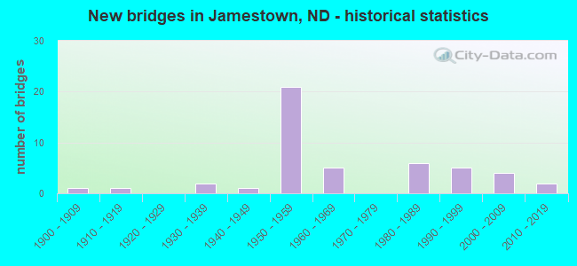
- New bridges - historical statistics
- 11900-1909
- 11910-1919
- 21930-1939
- 11940-1949
- 211950-1959
- 51960-1969
- 61980-1989
- 51990-1999
- 42000-2009
- 22010-2019
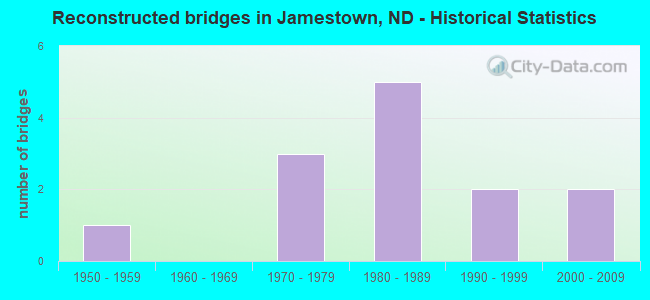
- Reconstructed bridges - Historical Statistics
- 11950-1959
- 01960-1969
- 31970-1979
- 51980-1989
- 21990-1999
- 22000-2009
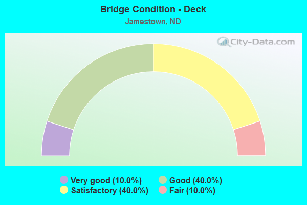
- Bridge Condition - Deck
- 10.0%Very good
- 40.0%Good
- 40.0%Satisfactory
- 10.0%Fair
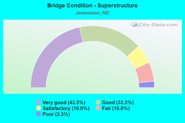
- Bridge Condition - Superstructure
- 43.3%Very good
- 33.3%Good
- 10.0%Satisfactory
- 10.0%Fair
- 3.3%Poor
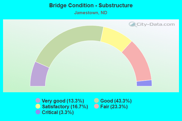
- Bridge Condition - Substructure
- 13.3%Very good
- 43.3%Good
- 16.7%Satisfactory
- 23.3%Fair
- 3.3%Critical
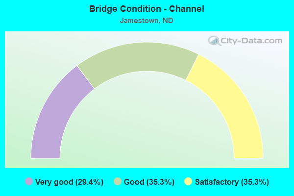
- Bridge Condition - Channel
- 29.4%Very good
- 35.3%Good
- 35.3%Satisfactory
Find on map >> Show street view
Structure Number: 4713529, Location: WEST SIDE OF JAMESTOWN (Lat: 46.915117, Lng: -98.735767), Route carried "on" structure: County highway 4728, Year Built: 1969, Status: Open, Structure Length: 1.86m (6.10ft), Average Daily Traffic: 450 (year 2018), Truck Traffic: 12%, Average Future Daily Traffic: 450 (year 2038), Design Load: H 20, Features Intersected: PIPESTEM CREEK, Facility Carried by Structure: COUNTY HIGHWAY
Minimum Vertical Clearance: 30+ m (98+ ft), Kilometerpoint: 13.677, Lanes on structure: 2, Owner: County Highway Agency, Approaching Roadway Width: 6.7m (22.0ft), Material/Design: Prestressed concrete, Design/Construction: Box Beam or Girders - Multiple, Number Of Spans In Main Unit: 1, Length of Maximum Span: 18.0m (59.1ft), Curb or Sidewalk Widths: Left: 0.2m (0.7ft), Right: 0.2m (0.7ft), Curb-To-Curb Width: 7.8m (25.6ft), Out-to-Out Width: 8.2m (26.9ft)
Condition: Deck: Good, Superstructure: Good, Substructure: Very good, Channel: Very good, Operating Rating: 32.7 metric tons, Method Used To Determine Operating Rating: Load Factor (LF), Inventory Rating: 19.6 metric tons, Method Used To Determine Inventory Rating: Load Factor (LF), Structural Evaluation: Somewhat better than minimum adequacy, Deck Geometry: Meets minimum limits, Waterway Adequacy: Equal to present minimum criteria, Approach Roadway Alignment: High priority of corrective action, Length Of Structure Improvement: 1.86m (6.10ft), Designated Inspection Frequency: Every 24 months, Inspection Date: August 2020, Bridge Improvement Cost: $41,000, Roadway Improvement Cost: $4,000, Total Project Cost: $62,000, Wearing Surface/Protective System: Wearing Surface: Bituminous
Find on map >> Show street view
Structure Number: 4713727, Location: RESERVOIR ISLAND (Lat: 46.942761, Lng: -98.702450), Route carried "on" structure: County highway , Year Built: 1901, Status: Closed, Structure Length: 1.87m (6.14ft), Average Daily Traffic: 135 (year 2020), Average Future Daily Traffic: 182 (year 2040), Features Intersected: JAMESTOWN RESERVOIR, Facility Carried by Structure: PARK ROAD
Minimum Vertical Clearance: 30+ m (98+ ft), Kilometerpoint: 0.000, Lanes on structure: 2, Owner: County Highway Agency, Approaching Roadway Width: 5.5m (18.0ft), Material/Design: Steel, Design/Construction: Truss - Thru, Number Of Spans In Main Unit: 1, Length of Maximum Span: 18.4m (60.4ft), Curb or Sidewalk Widths: Left: 0.2m (0.7ft), Right: 0.2m (0.7ft), Curb-To-Curb Width: 5.3m (17.4ft), Out-to-Out Width: 6.4m (21.0ft)
Condition: Deck: Fair, Superstructure: Poor, Substructure: Critical, Channel: Good, Operating Rating: 32.7 metric tons, Method Used To Determine Operating Rating: No rating analysis performed, Inventory Rating: 32.7 metric tons, Method Used To Determine Inventory Rating: No rating analysis performed, Structural Evaluation: High priority of replacement, Waterway Adequacy: Better than present minimum criteria, Approach Roadway Alignment: Better than present minimum criteria, Designated Inspection Frequency: Every 24 months, Critical Feature Inspection Frequency: Every 24 months, Inspection Date: November 2021, Critical Feature Inspection Date: November 2021, Deck Structure Type: Wood or Timber, Wearing Surface/Protective System: Wearing Surface: Wood or Timber
Find on map >> Show street view
Structure Number: 4714332, Location: 5 NORTH OF YPSILANTI (Lat: 46.863050, Lng: -98.568853), Route carried "on" structure: County highway , Year Built: 1962, Status: Open, Structure Length: 2.74m (8.99ft), Average Daily Traffic: 130 (year 2018), Truck Traffic: 13%, Average Future Daily Traffic: 130 (year 2038), Design Load: H 15, Features Intersected: JAMES RIVER, Facility Carried by Structure: TOWNSHIP ROAD
Minimum Vertical Clearance: 30+ m (98+ ft), Kilometerpoint: 0.000, Lanes on structure: 2, Owner: County Highway Agency, Approaching Roadway Width: 6.7m (22.0ft), Material/Design: Prestressed concrete, Design/Construction: Box Beam or Girders - Multiple, Number Of Spans In Main Unit: 2, Length of Maximum Span: 13.4m (44.0ft), Curb or Sidewalk Widths: Left: 0.8m (2.6ft), Right: 0.8m (2.6ft), Curb-To-Curb Width: 7.5m (24.6ft), Out-to-Out Width: 8.5m (27.9ft)
Condition: Deck: Satisfactory, Superstructure: Satisfactory, Substructure: Fair, Channel: Satisfactory, Operating Rating: 46.3 metric tons, Method Used To Determine Operating Rating: Load Factor (LF), Inventory Rating: 27.8 metric tons, Method Used To Determine Inventory Rating: Load Factor (LF), Structural Evaluation: Somewhat better than minimum adequacy, Deck Geometry: Somewhat better than minimum adequacy, Waterway Adequacy: Equal to present minimum criteria, Approach Roadway Alignment: Equal to present minimum criteria, Length Of Structure Improvement: 2.74m (8.99ft), Designated Inspection Frequency: Every 24 months, Inspection Date: October 2021, Bridge Improvement Cost: $63,000, Roadway Improvement Cost: $6,000, Total Project Cost: $95,000, Deck Structure Type: Concrete Precast Panels, Wearing Surface/Protective System: Wearing Surface: Monolithic Concrete
Find on map >> Show street view
Structure Number: JMTN01, Location: 4TH AVE. NW-JAMESTOWN (Lat: 46.918333, Lng: -98.710000), Route carried "on" structure: City street 8720, Year Built: 1947, Status: Open, Structure Length: 1.89m (6.20ft), Average Daily Traffic: 3,050 (year 2020), Truck Traffic: 3%, Average Future Daily Traffic: 3,500 (year 2040), Features Intersected: JAMES RIVER, Facility Carried by Structure: 4TH AVENUE NW
Minimum Vertical Clearance: 30+ m (98+ ft), Kilometerpoint: 1.548, Lanes on structure: 2, Owner: County Highway Agency, Approaching Roadway Width: 7.6m (24.9ft), Material/Design: Concrete continuous, Design/Construction: Tee Beam, Number Of Spans In Main Unit: 2, Length of Maximum Span: 8.8m (28.9ft), Curb or Sidewalk Widths: Left: 2.1m (6.9ft), Right: 0.2m (0.7ft), Curb-To-Curb Width: 7.9m (25.9ft), Out-to-Out Width: 10.2m (33.5ft)
Condition: Deck: Fair, Superstructure: Fair, Substructure: Fair, Channel: Good, Operating Rating: 64.8 metric tons, Method Used To Determine Operating Rating: Allowable Stress (AS), Inventory Rating: 25.2 metric tons, Method Used To Determine Inventory Rating: Allowable Stress (AS), Structural Evaluation: Somewhat better than minimum adequacy, Deck Geometry: High priority of corrective action, Waterway Adequacy: Equal to present minimum criteria, Approach Roadway Alignment: Equal to present minimum criteria, Length Of Structure Improvement: 1.89m (6.20ft), Designated Inspection Frequency: Every 24 months, Inspection Date: October 2021, Bridge Improvement Cost: $52,000, Roadway Improvement Cost: $5,000, Total Project Cost: $78,000, Deck Structure Type: Concrete Cast-file-Place, Wearing Surface/Protective System: Wearing Surface: Monolithic Concrete
Find on map >> Show street view
Structure Number: JMTN02, Location: 12TH AVE. SE-JAMESTOWN (Lat: 46.891667, Lng: -98.690000), Route carried "on" structure: City street 8760, Year Built: 1965, Status: Posted for load, Structure Length: 2.74m (8.99ft), Average Daily Traffic: 1,825 (year 2019), Truck Traffic: 1%, Average Future Daily Traffic: 2,100 (year 2039), Design Load: H 20, Features Intersected: DRAINAGE DITCH, Facility Carried by Structure: STATE HOSPITAL RD.
Minimum Vertical Clearance: 30+ m (98+ ft), Kilometerpoint: 0.080, Lanes on structure: 2, Owner: County Highway Agency, Approaching Roadway Width: 8.5m (27.9ft), Material/Design: Prestressed concrete, Design/Construction: Box Beam or Girders - Multiple, Number Of Spans In Main Unit: 2, Length of Maximum Span: 13.1m (43.0ft), Curb or Sidewalk Widths: Left: 1.3m (4.3ft), Right: 0.5m (1.6ft), Curb-To-Curb Width: 8.6m (28.2ft), Out-to-Out Width: 10.5m (34.4ft)
Condition: Deck: Very good, Superstructure: Very good, Substructure: Good, Channel: Good, Operating Rating: 89.8 metric tons, Method Used To Determine Operating Rating: Load Factor (LF), Inventory Rating: 47.6 metric tons, Method Used To Determine Inventory Rating: Load Factor (LF), Structural Evaluation: Better than present minimum criteria, Deck Geometry: Somewhat better than minimum adequacy, Waterway Adequacy: Equal to present minimum criteria, Approach Roadway Alignment: Equal to present minimum criteria, Length Of Structure Improvement: 2.74m (8.99ft), Designated Inspection Frequency: Every 24 months, Inspection Date: July 2021, Bridge Improvement Cost: $77,000, Roadway Improvement Cost: $8,000, Total Project Cost: $116,000, Deck Structure Type: Concrete Precast Panels, Wearing Surface/Protective System: Wearing Surface: Bituminous
Find on map >> Show street view
Structure Number: JMTN03, Location: 2ND STREET SW-JAMESTOWN (Lat: 46.906667, Lng: -98.731667), Route carried "on" structure: City street 8757, Year Built: 1986, Status: Open, Structure Length: 2.56m (8.40ft), Average Daily Traffic: 2,500 (year 2020), Truck Traffic: 4%, Average Future Daily Traffic: 3,000 (year 2040), Design Load: HS 20, Features Intersected: JAMES RIVER, Facility Carried by Structure: 2ND STREET SW
Minimum Vertical Clearance: 30+ m (98+ ft), Kilometerpoint: 1.512, Lanes on structure: 2, Owner: County Highway Agency, Approaching Roadway Width: 14.6m (47.9ft), Skew: 1 degrees, Material/Design: Prestressed concrete, Design/Construction: Box Beam or Girders - Single/Spread, Number Of Spans In Main Unit: 1, Length of Maximum Span: 24.4m (80.1ft), Curb or Sidewalk Widths: Left: 1.4m (4.6ft), Right: 1.4m (4.6ft), Curb-To-Curb Width: 9.1m (29.9ft), Out-to-Out Width: 13.0m (42.7ft)
Condition: Deck: Satisfactory, Superstructure: Very good, Substructure: Good, Channel: Very good, Operating Rating: 89.8 metric tons, Method Used To Determine Operating Rating: Load Factor (LF), Inventory Rating: 46.8 metric tons, Method Used To Determine Inventory Rating: Load Factor (LF), Structural Evaluation: Better than present minimum criteria, Deck Geometry: Meets minimum limits, Waterway Adequacy: Equal to present desirable criteria, Approach Roadway Alignment: Equal to present desirable criteria, Designated Inspection Frequency: Every 24 months, Inspection Date: October 2021, Deck Structure Type: Concrete Cast-file-Place, Wearing Surface/Protective System: Wearing Surface: Monolithic Concrete
Find on map >> Show street view
Structure Number: JMTN04, Location: 1ST STREET SW JAMESTOWN (Lat: 46.908333, Lng: -98.715000), Route carried "on" structure: City street 8757, Year Built: 2005, Status: Open, Structure Length: 3.60m (11.81ft), Average Daily Traffic: 1,045 (year 2019), Truck Traffic: 10%, Average Future Daily Traffic: 1,250 (year 2039), Design Load: HS 20, Features Intersected: JAMES RIVER, Facility Carried by Structure: 1ST STREET SW
Minimum Vertical Clearance: 30+ m (98+ ft), Kilometerpoint: 0.000, Lanes on structure: 2, Owner: City or Municipal Highway Agency, Approaching Roadway Width: 14.6m (47.9ft), Skew: 2 degrees, Material/Design: Prestressed concrete, Design/Construction: Box Beam or Girders - Single/Spread, Number Of Spans In Main Unit: 3, Length of Maximum Span: 11.9m (39.0ft), Curb or Sidewalk Widths: Left: 0.3m (1.0ft), Right: 2.1m (6.9ft), Curb-To-Curb Width: 9.8m (32.2ft), Out-to-Out Width: 12.2m (40.0ft)
Condition: Deck: Good, Superstructure: Very good, Substructure: Good, Channel: Very good, Operating Rating: 89.8 metric tons, Method Used To Determine Operating Rating: Load Factor (LF), Inventory Rating: 55.8 metric tons, Method Used To Determine Inventory Rating: Load Factor (LF), Structural Evaluation: Better than present minimum criteria, Deck Geometry: Somewhat better than minimum adequacy, Waterway Adequacy: Equal to present desirable criteria, Approach Roadway Alignment: Equal to present minimum criteria, Designated Inspection Frequency: Every 24 months, Inspection Date: October 2021, Deck Structure Type: Concrete Cast-file-Place, Wearing Surface/Protective System: Wearing Surface: Monolithic Concrete, Deck Protection: Epoxy Coated Reinforcing
Find on map >> Show street view
Structure Number: JMTN05, Location: 3RD ST. NW-JAMESTOWN (Lat: 46.913333, Lng: -98.715000), Route carried "on" structure: City street , Year Built: 1997, Status: Open, Structure Length: 3.20m (10.50ft), Average Daily Traffic: 1,122 (year 2019), Truck Traffic: 4%, Average Future Daily Traffic: 1,500 (year 2039), Design Load: HS 25 or greater, Features Intersected: JAMES RIVER, Facility Carried by Structure: 3RD STREET NW
Minimum Vertical Clearance: 30+ m (98+ ft), Kilometerpoint: 0.000, Lanes on structure: 2, Owner: County Highway Agency, Approaching Roadway Width: 8.5m (27.9ft), Material/Design: Concrete continuous, Design/Construction: Slab, Number Of Spans In Main Unit: 3, Length of Maximum Span: 11.0m (36.1ft), Curb or Sidewalk Widths: Left: 0.4m (1.3ft), Right: 2.2m (7.2ft), Curb-To-Curb Width: 8.5m (27.9ft), Out-to-Out Width: 11.1m (36.4ft)
Condition: Deck: Satisfactory, Superstructure: Good, Substructure: Very good, Channel: Very good, Operating Rating: 54.0 metric tons, Method Used To Determine Operating Rating: Load Factor (LF), Inventory Rating: 32.4 metric tons, Method Used To Determine Inventory Rating: Load Factor (LF), Structural Evaluation: Better than present minimum criteria, Deck Geometry: Somewhat better than minimum adequacy, Waterway Adequacy: Equal to present desirable criteria, Approach Roadway Alignment: Equal to present minimum criteria, Designated Inspection Frequency: Every 24 months, Inspection Date: October 2021, Deck Structure Type: Concrete Cast-file-Place, Wearing Surface/Protective System: Wearing Surface: Monolithic Concrete, Deck Protection: Epoxy Coated Reinforcing
Find on map >> Show street view
Structure Number: JMTN08, Location: SOUTH OF I-94 ON CORP LIM (Lat: 46.883333, Lng: -98.668333), Route carried "on" structure: City street 8766, Year Built: 1968, Status: Open, Structure Length: 2.74m (8.99ft), Average Daily Traffic: 1,000 (year 2019), Truck Traffic: 3%, Average Future Daily Traffic: 1,300 (year 2039), Design Load: H 20, Features Intersected: JAMES RIVER, Facility Carried by Structure: CITY STREET
Minimum Vertical Clearance: 30+ m (98+ ft), Kilometerpoint: 1.368, Lanes on structure: 2, Owner: County Highway Agency, Approaching Roadway Width: 7.6m (24.9ft), Material/Design: Prestressed concrete, Design/Construction: Box Beam or Girders - Multiple, Number Of Spans In Main Unit: 2, Length of Maximum Span: 13.1m (43.0ft), Curb-To-Curb Width: 8.7m (28.5ft), Out-to-Out Width: 9.2m (30.2ft)
Condition: Deck: Very good, Superstructure: Very good, Substructure: Good, Channel: Good, Operating Rating: 44.1 metric tons, Method Used To Determine Operating Rating: Allowable Stress (AS), Inventory Rating: 19.8 metric tons, Method Used To Determine Inventory Rating: Allowable Stress (AS), Structural Evaluation: Somewhat better than minimum adequacy, Deck Geometry: Somewhat better than minimum adequacy, Waterway Adequacy: Equal to present minimum criteria, Approach Roadway Alignment: Equal to present minimum criteria, Length Of Structure Improvement: 2.74m (8.99ft), Designated Inspection Frequency: Every 24 months, Inspection Date: July 2021, Bridge Improvement Cost: $68,000, Roadway Improvement Cost: $7,000, Total Project Cost: $102,000, Deck Structure Type: Concrete Precast Panels, Wearing Surface/Protective System: Wearing Surface: Bituminous
Find on map >> Show street view
Structure Number: JMTN09, Location: S. OF 2ND ST SW-JAMESTOWN (Lat: 46.928333, Lng: -98.733333), Route carried "on" structure: City street 8710, Year Built: 1992, Status: Open, Structure Length: 2.26m (7.41ft), Average Daily Traffic: 300 (year 2019), Truck Traffic: 10%, Average Future Daily Traffic: 400 (year 2039), Design Load: HS 25 or greater, Features Intersected: PIPESTEM CREEK, Facility Carried by Structure: 17TH AVENUE SW
Minimum Vertical Clearance: 30+ m (98+ ft), Kilometerpoint: 0.965, Lanes on structure: 2, Owner: County Highway Agency, Approaching Roadway Width: 7.3m (24.0ft), Material/Design: Prestressed concrete, Design/Construction: Box Beam or Girders - Single/Spread, Number Of Spans In Main Unit: 1, Length of Maximum Span: 21.3m (69.9ft), Curb or Sidewalk Widths: Left: 0.4m (1.3ft), Right: 0.4m (1.3ft), Curb-To-Curb Width: 8.5m (27.9ft), Out-to-Out Width: 9.3m (30.5ft)
Condition: Deck: Satisfactory, Superstructure: Very good, Substructure: Fair, Channel: Very good, Operating Rating: 89.8 metric tons, Method Used To Determine Operating Rating: Load Factor (LF), Inventory Rating: 34.2 metric tons, Method Used To Determine Inventory Rating: Load Factor (LF), Structural Evaluation: Somewhat better than minimum adequacy, Deck Geometry: Equal to present minimum criteria, Waterway Adequacy: Equal to present desirable criteria, Approach Roadway Alignment: Better than present minimum criteria, Designated Inspection Frequency: Every 24 months, Inspection Date: October 2021, Deck Structure Type: Concrete Cast-file-Place, Wearing Surface/Protective System: Wearing Surface: Monolithic Concrete
Find on map >> Show street view
Structure Number: 52264943, Location: 1 NORTHWEST OF ND 20 (Lat: 46.913333, Lng: -98.715000), Route carried "on" structure: US 52, Year Built: 1939, Year Reconstructed: 1963, Status: Open, Structure Length: 3.29m (10.79ft), Average Daily Traffic: 5,600 (year 2020), Truck Traffic: 9%, Average Future Daily Traffic: 7,810 (year 2040), Design Load: H 20, Features Intersected: JAMES RIVER
Minimum Vertical Clearance: 30+ m (98+ ft), Kilometerpoint: 426.293, Lanes on structure: 4, Base Highway Network: Yes, Owner: State Highway Agency, Approaching Roadway Width: 14.0m (45.9ft), Material/Design: Steel, Design/Construction: Stringer/Multi-beam, Number Of Spans In Main Unit: 2, Length of Maximum Span: 14.9m (48.9ft), Curb or Sidewalk Widths: Left: 1.4m (4.6ft), Right: 2.0m (6.6ft), Curb-To-Curb Width: 16.5m (54.1ft), Out-to-Out Width: 20.8m (68.2ft)
Condition: Deck: Good, Superstructure: Good, Substructure: Satisfactory, Channel: Satisfactory, Operating Rating: 63.5 metric tons, Method Used To Determine Operating Rating: Load Factor (LF), Inventory Rating: 38.0 metric tons, Method Used To Determine Inventory Rating: Load Factor (LF), Structural Evaluation: Equal to present minimum criteria, Deck Geometry: Meets minimum limits, Waterway Adequacy: Equal to present desirable criteria, Approach Roadway Alignment: Equal to present minimum criteria, Length Of Structure Improvement: 3.29m (10.79ft), Designated Inspection Frequency: Every 24 months, Inspection Date: October 2021, Bridge Improvement Cost: $184,000, Roadway Improvement Cost: $18,000, Total Project Cost: $276,000, Deck Structure Type: Concrete Cast-file-Place, Wearing Surface/Protective System: Wearing Surface: Low Slump Concrete
Find on map >> Show street view
Structure Number: 52915484, Location: WEST JAMESTOWN BYPASS (Lat: 46.935000, Lng: -98.740000), Route carried "on" structure: US 52, Year Built: 2003, Status: Open, Structure Length: 6.77m (22.21ft), Average Daily Traffic: 4,200 (year 2019), Truck Traffic: 14%, Average Future Daily Traffic: 5,950 (year 2039), Design Load: HS 25 or greater, Features Intersected: RED R. VALLEY/WESTERN RR
Minimum Vertical Clearance: 30+ m (98+ ft), Kilometerpoint: 1473.014, Lanes on structure: 2, Owner: State Highway Agency, Approaching Roadway Width: 12.2m (40.0ft), Skew: 1 degrees, Material/Design: Prestressed concrete continuous, Design/Construction: Stringer/Multi-beam, Number Of Spans In Main Unit: 3, Length of Maximum Span: 21.3m (69.9ft), Curb-To-Curb Width: 12.2m (40.0ft), Out-to-Out Width: 13.0m (42.7ft)
Condition: Deck: Very good, Superstructure: Very good, Substructure: Very good, Operating Rating: 89.8 metric tons, Method Used To Determine Operating Rating: Load Factor (LF), Inventory Rating: 60.9 metric tons, Method Used To Determine Inventory Rating: Load Factor (LF), Structural Evaluation: Equal to present desirable criteria, Deck Geometry: Equal to present minimum criteria, Underclear: Superior to present desirable criteria, Approach Roadway Alignment: Equal to present desirable criteria, Designated Inspection Frequency: Every 24 months, Inspection Date: November 2020, Deck Structure Type: Concrete Cast-file-Place, Wearing Surface/Protective System: Wearing Surface: Monolithic Concrete, Deck Protection: Epoxy Coated Reinforcing
Find on map >> Show street view
Structure Number: 52915716, Location: WEST JAMESTOWN BYPASS (Lat: 46.933333, Lng: -98.741667), Route carried "on" structure: US 52, Year Built: 2003, Status: Open, Structure Length: 11.43m (37.50ft), Average Daily Traffic: 4,200 (year 2019), Truck Traffic: 14%, Average Future Daily Traffic: 5,950 (year 2039), Design Load: HS 25 or greater, Features Intersected: PIPESTEM CREEK
Minimum Vertical Clearance: 30+ m (98+ ft), Kilometerpoint: 1473.387, Lanes on structure: 2, Owner: State Highway Agency, Approaching Roadway Width: 12.2m (40.0ft), Skew: 1 degrees, Material/Design: Prestressed concrete continuous, Design/Construction: Stringer/Multi-beam, Number Of Spans In Main Unit: 3, Length of Maximum Span: 37.2m (122.0ft), Curb-To-Curb Width: 12.2m (40.0ft), Out-to-Out Width: 13.0m (42.7ft)
Condition: Deck: Good, Superstructure: Very good, Substructure: Good, Channel: Good, Operating Rating: 89.8 metric tons, Method Used To Determine Operating Rating: Load Factor (LF), Inventory Rating: 63.4 metric tons, Method Used To Determine Inventory Rating: Load Factor (LF), Structural Evaluation: Better than present minimum criteria, Deck Geometry: Equal to present minimum criteria, Waterway Adequacy: Superior to present desirable criteria, Approach Roadway Alignment: Equal to present desirable criteria, Designated Inspection Frequency: Every 24 months, Inspection Date: November 2020, Deck Structure Type: Concrete Cast-file-Place, Wearing Surface/Protective System: Wearing Surface: Monolithic Concrete, Deck Protection: Epoxy Coated Reinforcing
Find on map >> Show street view
Structure Number: 52917499, Location: WEST JAMESTOWN BYPASS (Lat: 46.906667, Lng: -98.751667), Route carried "on" structure: US 52, Year Built: 2003, Status: Open, Structure Length: 19.81m (64.99ft), Average Daily Traffic: 4,200 (year 2019), Truck Traffic: 14%, Average Future Daily Traffic: 5,950 (year 2039), Design Load: HS 25 or greater, Features Intersected: BN-SANTA FE RAILWAY
Minimum Vertical Clearance: 30+ m (98+ ft), Kilometerpoint: 1476.256, Lanes on structure: 2, Owner: State Highway Agency, Approaching Roadway Width: 12.2m (40.0ft), Material/Design: Prestressed concrete continuous, Design/Construction: Stringer/Multi-beam, Number Of Spans In Main Unit: 5, Length of Maximum Span: 45.1m (148.0ft), Curb-To-Curb Width: 12.2m (40.0ft), Out-to-Out Width: 13.0m (42.7ft)
Condition: Deck: Good, Superstructure: Very good, Substructure: Good, Operating Rating: 89.8 metric tons, Method Used To Determine Operating Rating: Load Factor (LF), Inventory Rating: 68.9 metric tons, Method Used To Determine Inventory Rating: Load Factor (LF), Structural Evaluation: Better than present minimum criteria, Deck Geometry: Equal to present minimum criteria, Underclear: Superior to present desirable criteria, Approach Roadway Alignment: Equal to present desirable criteria, Designated Inspection Frequency: Every 24 months, Inspection Date: November 2020, Deck Structure Type: Concrete Cast-file-Place, Wearing Surface/Protective System: Wearing Surface: Monolithic Concrete, Deck Protection: Epoxy Coated Reinforcing
Find on map >> Show street view
Structure Number: 94256224, Location: 2 WEST OF JAMESTOWN (Lat: 46.893333, Lng: -98.753333), Route carried "on" structure: Bypass US 52, Year Built: 1959, Year Reconstructed: 1991, Status: Open, Structure Length: 6.40m (21.00ft), Average Daily Traffic: 400 (year 2020), Truck Traffic: 12%, Average Future Daily Traffic: 400 (year 2040), Design Load: HS 20, Features Intersected: I 94/US 52 BYPASS
Minimum Vertical Clearance: 30+ m (98+ ft), Kilometerpoint: 1477.825, Lanes on structure: 2, Lanes under structure: 4, Owner: State Highway Agency, Approaching Roadway Width: 11.0m (36.1ft), Material/Design: Prestressed concrete continuous, Design/Construction: Stringer/Multi-beam, Number Of Spans In Main Unit: 4, Length of Maximum Span: 17.7m (58.1ft), Curb-To-Curb Width: 12.2m (40.0ft), Out-to-Out Width: 13.0m (42.7ft)
Condition: Deck: Good, Superstructure: Very good, Substructure: Satisfactory, Operating Rating: 51.7 metric tons, Method Used To Determine Operating Rating: Load Factor (LF), Inventory Rating: 30.9 metric tons, Method Used To Determine Inventory Rating: Load Factor (LF), Structural Evaluation: Equal to present minimum criteria, Deck Geometry: Superior to present desirable criteria, Underclear: Meets minimum limits, Approach Roadway Alignment: Equal to present minimum criteria, Designated Inspection Frequency: Every 24 months, Inspection Date: October 2021, Deck Structure Type: Concrete Cast-file-Place, Wearing Surface/Protective System: Wearing Surface: Low Slump Concrete, Deck Protection: Epoxy Coated Reinforcing
Find on map >> Show street view
Structure Number: 94257002, Location: 1 WEST OF US 281 (Lat: 46.891525, Lng: -98.738247), Route carried "on" structure: Business State highway 94, Year Built: 1957, Year Reconstructed: 1979, Status: Open, Structure Length: 5.33m (17.49ft), Average Daily Traffic: 2,500 (year 2020), Truck Traffic: 6%, Average Future Daily Traffic: 1,950 (year 2040), Design Load: HS 20, Features Intersected: I-94/WEST JAMESTOWN INT
Minimum Vertical Clearance: 30+ m (98+ ft), Kilometerpoint: 1491.331, Lanes on structure: 1, Lanes under structure: 2, Base Highway Network: Yes, Owner: State Highway Agency, Approaching Roadway Width: 5.5m (18.0ft), Skew: 4 degrees, Material/Design: Steel continuous, Design/Construction: Stringer/Multi-beam, Number Of Spans In Main Unit: 3, Length of Maximum Span: 19.8m (65.0ft), Curb-To-Curb Width: 7.9m (25.9ft), Out-to-Out Width: 9.8m (32.2ft)
Condition: Deck: Fair, Superstructure: Fair, Substructure: Fair, Operating Rating: 76.6 metric tons, Method Used To Determine Operating Rating: Load Factor (LF), Inventory Rating: 45.8 metric tons, Method Used To Determine Inventory Rating: Load Factor (LF), Structural Evaluation: Somewhat better than minimum adequacy, Deck Geometry: High priority of corrective action, Underclear: High priority of corrective action, Approach Roadway Alignment: Better than present minimum criteria, Designated Inspection Frequency: Every 24 months, Inspection Date: October 2021, Deck Structure Type: Concrete Cast-file-Place, Wearing Surface/Protective System: Wearing Surface: Low Slump Concrete
Find on map >> Show street view
Structure Number: 94258055, Location: JCT US 281 & I-94 (Lat: 46.885850, Lng: -98.718011), Route carried "on" structure: US 281, Year Built: 1957, Year Reconstructed: 1983, Status: Open, Structure Length: 8.53m (27.99ft), Average Daily Traffic: 13,300 (year 2020), Truck Traffic: 5%, Average Future Daily Traffic: 11,700 (year 2040), Design Load: HS 20, Features Intersected: I-94/US 281 INTERCHANGE
Minimum Vertical Clearance: 30+ m (98+ ft), Kilometerpoint: 108.588, Lanes on structure: 4, Lanes under structure: 4, Base Highway Network: Yes, Owner: State Highway Agency, Approaching Roadway Width: 21.3m (69.9ft), Skew: 23 degrees, Material/Design: Steel, Design/Construction: Stringer/Multi-beam, Number Of Spans In Main Unit: 4, Length of Maximum Span: 23.5m (77.1ft), Curb or Sidewalk Widths: Left: 2.4m (7.9ft), Right: 0.0m, Curb-To-Curb Width: 22.0m (72.2ft), Out-to-Out Width: 25.4m (83.3ft)
Condition: Deck: Satisfactory, Superstructure: Satisfactory, Substructure: Satisfactory, Operating Rating: 53.1 metric tons, Method Used To Determine Operating Rating: Load Factor (LF), Inventory Rating: 31.8 metric tons, Method Used To Determine Inventory Rating: Load Factor (LF), Structural Evaluation: Equal to present minimum criteria, Deck Geometry: Superior to present desirable criteria, Underclear: High priority of corrective action, Approach Roadway Alignment: Better than present minimum criteria, Designated Inspection Frequency: Every 24 months, Inspection Date: October 2021, Deck Structure Type: Concrete Cast-file-Place, Wearing Surface/Protective System: Wearing Surface: Low Slump Concrete
Find on map >> Show street view
Structure Number: 94259523 L, Location: 1 EAST OF US 281 (Lat: 46.887486, Lng: -98.688356), Route carried "on" structure: Interstate 94, Year Built: 1957, Year Reconstructed: 1997, Status: Open, Structure Length: 3.35m (10.99ft), Average Daily Traffic: 3,400 (year 2020), Truck Traffic: 23%, Average Future Daily Traffic: 3,400 (year 2040), Design Load: HS 20, Features Intersected: HOSPITAL ROAD SEPARATION
Minimum Vertical Clearance: 30+ m (98+ ft), Kilometerpoint: 417.573, Lanes on structure: 2, Lanes under structure: 2, Base Highway Network: Yes, Owner: State Highway Agency, Approaching Roadway Width: 11.6m (38.1ft), Skew: 10 degrees, Material/Design: Concrete continuous, Design/Construction: Slab, Number Of Spans In Main Unit: 3, Length of Maximum Span: 12.5m (41.0ft), Curb-To-Curb Width: 12.3m (40.4ft), Out-to-Out Width: 13.8m (45.3ft)
Condition: Deck: Good, Superstructure: Good, Substructure: Good, Operating Rating: 52.5 metric tons, Method Used To Determine Operating Rating: Load Factor (LF), Inventory Rating: 31.5 metric tons, Method Used To Determine Inventory Rating: Load Factor (LF), Structural Evaluation: Better than present minimum criteria, Deck Geometry: Better than present minimum criteria, Underclear: Somewhat better than minimum adequacy, Approach Roadway Alignment: Equal to present desirable criteria, Designated Inspection Frequency: Every 24 months, Inspection Date: October 2021, Deck Structure Type: Concrete Cast-file-Place, Wearing Surface/Protective System: Wearing Surface: Low Slump Concrete
Find on map >> Show street view
Structure Number: 94259523 R, Location: 1 EAST OF US 281 (Lat: 46.887281, Lng: -98.688269), Route carried "on" structure: Interstate 94, Year Built: 1957, Year Reconstructed: 1980, Status: Open, Structure Length: 3.35m (10.99ft), Average Daily Traffic: 3,400 (year 2020), Truck Traffic: 23%, Average Future Daily Traffic: 3,400 (year 2040), Design Load: HS 20, Features Intersected: HOSPITAL ROAD SEPARATION
Minimum Vertical Clearance: 30+ m (98+ ft), Kilometerpoint: 417.573, Lanes on structure: 2, Lanes under structure: 2, Base Highway Network: Yes, Owner: State Highway Agency, Approaching Roadway Width: 11.6m (38.1ft), Skew: 10 degrees, Material/Design: Concrete continuous, Design/Construction: Slab, Number Of Spans In Main Unit: 3, Length of Maximum Span: 12.5m (41.0ft), Curb-To-Curb Width: 12.3m (40.4ft), Out-to-Out Width: 13.8m (45.3ft)
Condition: Deck: Good, Superstructure: Good, Substructure: Good, Operating Rating: 52.5 metric tons, Method Used To Determine Operating Rating: Load Factor (LF), Inventory Rating: 31.5 metric tons, Method Used To Determine Inventory Rating: Load Factor (LF), Structural Evaluation: Better than present minimum criteria, Deck Geometry: Better than present minimum criteria, Underclear: Meets minimum limits, Approach Roadway Alignment: Equal to present desirable criteria, Designated Inspection Frequency: Every 24 months, Inspection Date: October 2021, Deck Structure Type: Concrete Cast-file-Place, Wearing Surface/Protective System: Wearing Surface: Low Slump Concrete
Find on map >> Show street view
Structure Number: 94259847 L, Location: JUST WEST JCT. 52 & I-94 (Lat: 46.888333, Lng: -98.680000), Route carried "on" structure: Interstate 94, Year Built: 1957, Year Reconstructed: 1991, Status: Open, Structure Length: 6.71m (22.01ft), Average Daily Traffic: 3,400 (year 2020), Truck Traffic: 23%, Average Future Daily Traffic: 3,400 (year 2040), Design Load: HS 20, Features Intersected: JAMES RIVER
Minimum Vertical Clearance: 30+ m (98+ ft), Kilometerpoint: 418.094, Lanes on structure: 3, Base Highway Network: Yes, Owner: State Highway Agency, Approaching Roadway Width: 14.6m (47.9ft), Skew: 10 degrees, Material/Design: Steel continuous, Design/Construction: Stringer/Multi-beam, Number Of Spans In Main Unit: 3, Length of Maximum Span: 25.3m (83.0ft), Curb-To-Curb Width: 14.0m (45.9ft), Out-to-Out Width: 14.8m (48.6ft)
Condition: Deck: Satisfactory, Superstructure: Good, Substructure: Good, Channel: Satisfactory, Operating Rating: 56.2 metric tons, Method Used To Determine Operating Rating: Load Factor (LF), Inventory Rating: 33.6 metric tons, Method Used To Determine Inventory Rating: Load Factor (LF), Structural Evaluation: Better than present minimum criteria, Deck Geometry: Meets minimum limits, Waterway Adequacy: Equal to present desirable criteria, Approach Roadway Alignment: Equal to present desirable criteria, Designated Inspection Frequency: Every 24 months, Inspection Date: October 2021, Deck Structure Type: Concrete Cast-file-Place, Wearing Surface/Protective System: Wearing Surface: Monolithic Concrete, Deck Protection: Epoxy Coated Reinforcing
Find on map >> Show street view
Structure Number: 94259847 R, Location: JUST WEST JCT. 52 & I-94 (Lat: 46.888333, Lng: -98.680000), Route carried "on" structure: Interstate 94, Year Built: 1957, Year Reconstructed: 1991, Status: Open, Structure Length: 6.71m (22.01ft), Average Daily Traffic: 3,400 (year 2020), Truck Traffic: 23%, Average Future Daily Traffic: 3,400 (year 2040), Design Load: HS 20, Features Intersected: JAMES RIVER
Minimum Vertical Clearance: 30+ m (98+ ft), Kilometerpoint: 418.094, Lanes on structure: 3, Base Highway Network: Yes, Owner: State Highway Agency, Approaching Roadway Width: 14.6m (47.9ft), Skew: 10 degrees, Material/Design: Steel continuous, Design/Construction: Stringer/Multi-beam, Number Of Spans In Main Unit: 3, Length of Maximum Span: 25.3m (83.0ft), Curb-To-Curb Width: 14.0m (45.9ft), Out-to-Out Width: 14.8m (48.6ft)
Condition: Deck: Satisfactory, Superstructure: Good, Substructure: Good, Channel: Satisfactory, Operating Rating: 61.9 metric tons, Method Used To Determine Operating Rating: Load Factor (LF), Inventory Rating: 37.0 metric tons, Method Used To Determine Inventory Rating: Load Factor (LF), Structural Evaluation: Better than present minimum criteria, Deck Geometry: Meets minimum limits, Waterway Adequacy: Equal to present desirable criteria, Approach Roadway Alignment: Equal to present desirable criteria, Designated Inspection Frequency: Every 24 months, Inspection Date: October 2021, Deck Structure Type: Concrete Cast-file-Place, Wearing Surface/Protective System: Wearing Surface: Monolithic Concrete, Deck Protection: Epoxy Coated Reinforcing
Find on map >> Show street view
Structure Number: 94260125 L, Location: SE JAMESTOWN INTERCHANGE (Lat: 46.890000, Lng: -98.673333), Route carried "on" structure: Interstate 94, Year Built: 2017, Status: Open, Structure Length: 7.59m (24.90ft), Average Daily Traffic: 4,560 (year 2020), Truck Traffic: 20%, Average Future Daily Traffic: 6,990 (year 2040), Design Load: HL 93, Features Intersected: BNRR & SE JAMESTOWN INT
Minimum Vertical Clearance: 30+ m (98+ ft), Kilometerpoint: 418.541, Lanes on structure: 2, Lanes under structure: 2, Base Highway Network: Yes, Owner: State Highway Agency, Approaching Roadway Width: 11.6m (38.1ft), Skew: 11 degrees, Material/Design: Prestressed concrete continuous, Design/Construction: Box Beam or Girders - Single/Spread, Number Of Spans In Main Unit: 4, Length of Maximum Span: 21.3m (69.9ft), Curb-To-Curb Width: 14.6m (47.9ft), Out-to-Out Width: 15.5m (50.9ft)
Condition: Deck: Good, Superstructure: Very good, Substructure: Very good, Operating Rating: 47.3 metric tons, Method Used To Determine Operating Rating: Load and Resistance Factor Rating (LRFR) rating reported by rating factor(RF) method using HL-93 loadings, Inventory Rating: 36.6 metric tons, Method Used To Determine Inventory Rating: Load and Resistance Factor Rating (LRFR) rating reported by rating factor(RF) method using HL-93 loadings, Structural Evaluation: Equal to present desirable criteria, Deck Geometry: Superior to present desirable criteria, Underclear: Equal to present minimum criteria, Approach Roadway Alignment: Better than present minimum criteria, Length Of Structure Improvement: 6.74m (22.11ft), Designated Inspection Frequency: Every 24 months, Inspection Date: October 2021, Bridge Improvement Cost: $260,000, Roadway Improvement Cost: $26,000, Total Project Cost: $390,000, Deck Structure Type: Concrete Cast-file-Place, Wearing Surface/Protective System: Wearing Surface: Monolithic Concrete, Deck Protection: Epoxy Coated Reinforcing
Find on map >> Show street view
Structure Number: 94260125 R, Location: SE JAMESTOWN INTERCHANGE (Lat: 46.890000, Lng: -98.673333), Route carried "on" structure: Interstate 94, Year Built: 1958, Year Reconstructed: 2011, Status: Open, Structure Length: 6.74m (22.11ft), Average Daily Traffic: 4,100 (year 2020), Truck Traffic: 20%, Average Future Daily Traffic: 4,100 (year 2040), Design Load: HS 20, Features Intersected: BNRR & SE JAMESTOWN INT
Minimum Vertical Clearance: 30+ m (98+ ft), Kilometerpoint: 418.541, Lanes on structure: 2, Lanes under structure: 2, Base Highway Network: Yes, Owner: State Highway Agency, Approaching Roadway Width: 11.6m (38.1ft), Skew: 11 degrees, Material/Design: Prestressed concrete, Design/Construction: Stringer/Multi-beam, Number Of Spans In Main Unit: 4, Length of Maximum Span: 17.4m (57.1ft), Curb-To-Curb Width: 14.0m (45.9ft), Out-to-Out Width: 15.1m (49.5ft)
Condition: Deck: Satisfactory, Superstructure: Fair, Substructure: Satisfactory, Operating Rating: 69.3 metric tons, Method Used To Determine Operating Rating: Load Factor (LF), Inventory Rating: 37.6 metric tons, Method Used To Determine Inventory Rating: Load Factor (LF), Structural Evaluation: Somewhat better than minimum adequacy, Deck Geometry: Superior to present desirable criteria, Underclear: Equal to present minimum criteria, Approach Roadway Alignment: Better than present minimum criteria, Designated Inspection Frequency: Every 24 months, Inspection Date: October 2021, Deck Structure Type: Concrete Cast-file-Place, Wearing Surface/Protective System: Wearing Surface: Low Slump Concrete
Find on map >> Show street view
Structure Number: 94260304 L, Location: JUST EAST OF JCT US 52 (Lat: 46.890000, Lng: -98.671667), Route carried "on" structure: Interstate 94, Year Built: 1958, Year Reconstructed: 1991, Status: Open, Structure Length: 6.71m (22.01ft), Average Daily Traffic: 4,100 (year 2020), Truck Traffic: 20%, Average Future Daily Traffic: 4,100 (year 2040), Design Load: HS 20, Features Intersected: BNRR SEP-MINOR ROAD
Minimum Vertical Clearance: 30+ m (98+ ft), Kilometerpoint: 418.829, Lanes on structure: 2, Lanes under structure: 2, Base Highway Network: Yes, Owner: State Highway Agency, Approaching Roadway Width: 11.6m (38.1ft), Skew: 13 degrees, Material/Design: Steel continuous, Design/Construction: Stringer/Multi-beam, Number Of Spans In Main Unit: 4, Length of Maximum Span: 17.7m (58.1ft), Curb-To-Curb Width: 12.2m (40.0ft), Out-to-Out Width: 13.0m (42.7ft)
Condition: Deck: Good, Superstructure: Good, Substructure: Fair, Operating Rating: 72.7 metric tons, Method Used To Determine Operating Rating: Load Factor (LF), Inventory Rating: 43.5 metric tons, Method Used To Determine Inventory Rating: Load Factor (LF), Structural Evaluation: Somewhat better than minimum adequacy, Deck Geometry: Better than present minimum criteria, Underclear: Somewhat better than minimum adequacy, Approach Roadway Alignment: Better than present minimum criteria, Designated Inspection Frequency: Every 24 months, Inspection Date: October 2021, Deck Structure Type: Concrete Cast-file-Place, Wearing Surface/Protective System: Wearing Surface: Monolithic Concrete, Deck Protection: Epoxy Coated Reinforcing
Find on map >> Show street view
Structure Number: 94260304 R, Location: JUST EAST OF JCT.US-52 (Lat: 46.890000, Lng: -98.671667), Route carried "on" structure: Interstate 94, Year Built: 1958, Year Reconstructed: 2011, Status: Open, Structure Length: 6.71m (22.01ft), Average Daily Traffic: 4,100 (year 2020), Truck Traffic: 20%, Average Future Daily Traffic: 4,100 (year 2040), Design Load: HS 20, Features Intersected: BNRR SEP/MINOR ROAD
Minimum Vertical Clearance: 30+ m (98+ ft), Kilometerpoint: 418.829, Lanes on structure: 2, Lanes under structure: 2, Base Highway Network: Yes, Owner: State Highway Agency, Approaching Roadway Width: 11.6m (38.1ft), Skew: 13 degrees, Material/Design: Steel continuous, Design/Construction: Stringer/Multi-beam, Number Of Spans In Main Unit: 4, Length of Maximum Span: 17.7m (58.1ft), Curb-To-Curb Width: 14.0m (45.9ft), Out-to-Out Width: 14.8m (48.6ft)
Condition: Deck: Satisfactory, Superstructure: Good, Substructure: Fair, Operating Rating: 72.7 metric tons, Method Used To Determine Operating Rating: Load Factor (LF), Inventory Rating: 43.5 metric tons, Method Used To Determine Inventory Rating: Load Factor (LF), Structural Evaluation: Somewhat better than minimum adequacy, Deck Geometry: Superior to present desirable criteria, Underclear: Meets minimum limits, Approach Roadway Alignment: Better than present minimum criteria, Designated Inspection Frequency: Every 24 months, Inspection Date: October 2021, Deck Structure Type: Concrete Cast-file-Place, Wearing Surface/Protective System: Wearing Surface: Monolithic Concrete, Deck Protection: Epoxy Coated Reinforcing
Find on map >> Show street view
Structure Number: 94262361, Location: 2 EAST OF US 52 (Lat: 46.891667, Lng: -98.628333), Route carried "on" structure: County highway 4739, Year Built: 1997, Status: Open, Structure Length: 6.22m (20.41ft), Average Daily Traffic: 630 (year 2020), Truck Traffic: 15%, Average Future Daily Traffic: 1,140 (year 2040), Design Load: HS 25 or greater, Features Intersected: I-94/BLOOM INTERCHANGE
Minimum Vertical Clearance: 30+ m (98+ ft), Kilometerpoint: 0.002, Lanes on structure: 2, Lanes under structure: 4, Owner: State Highway Agency, Approaching Roadway Width: 7.3m (24.0ft), Material/Design: Prestressed concrete continuous, Design/Construction: Box Beam or Girders - Single/Spread, Number Of Spans In Main Unit: 4, Length of Maximum Span: 20.1m (65.9ft), Curb-To-Curb Width: 11.0m (36.1ft), Out-to-Out Width: 11.7m (38.4ft)
Condition: Deck: Satisfactory, Superstructure: Very good, Substructure: Good, Operating Rating: 84.2 metric tons, Method Used To Determine Operating Rating: Load Factor (LF), Inventory Rating: 50.3 metric tons, Method Used To Determine Inventory Rating: Load Factor (LF), Structural Evaluation: Better than present minimum criteria, Deck Geometry: Better than present minimum criteria, Underclear: Equal to present minimum criteria, Approach Roadway Alignment: Equal to present desirable criteria, Designated Inspection Frequency: Every 24 months, Inspection Date: November 2021, Deck Structure Type: Concrete Cast-file-Place, Wearing Surface/Protective System: Wearing Surface: Monolithic Concrete, Deck Protection: Epoxy Coated Reinforcing
Find on map >> Show street view
Structure Number: 94265371, Location: 7 EAST OF US 281 (Lat: 46.891667, Lng: -98.565000), Route carried "on" structure: Interstate 94, Year Built: 1958, Status: Open, Structure Length: 0.64m (2.10ft), Average Daily Traffic: 8,400 (year 2020), Truck Traffic: 19%, Average Future Daily Traffic: 8,400 (year 2040), Design Load: HS 20, Features Intersected: CREEK
Minimum Vertical Clearance: 30+ m (98+ ft), Kilometerpoint: 426.982, Lanes on structure: 4, Base Highway Network: Yes, Owner: State Highway Agency, Approaching Roadway Width: 23.2m (76.1ft), Material/Design: Steel, Design/Construction: Culvert, Number Of Spans In Main Unit: 2, Length of Maximum Span: 3.0m (9.8ft)
Condition: Channel: Good, Culverts: Good, Operating Rating: 54.0 metric tons, Method Used To Determine Operating Rating: Load Factor (LF), Inventory Rating: 32.4 metric tons, Method Used To Determine Inventory Rating: Load Factor (LF), Structural Evaluation: Better than present minimum criteria, Waterway Adequacy: Equal to present desirable criteria, Approach Roadway Alignment: Better than present minimum criteria, Designated Inspection Frequency: Every 24 months, Inspection Date: October 2021
Find on map >> Show street view
Structure Number: 94265699 L, Location: 8 EAST OF US 281 (Lat: 46.892153, Lng: -98.558961), Route carried "on" structure: Interstate 94, Year Built: 1988, Status: Open, Structure Length: 3.05m (10.01ft), Average Daily Traffic: 4,200 (year 2020), Truck Traffic: 19%, Average Future Daily Traffic: 4,200 (year 2040), Design Load: HS 20, Features Intersected: MINOR ROAD SEPARATION
Minimum Vertical Clearance: 30+ m (98+ ft), Kilometerpoint: 427.510, Lanes on structure: 2, Lanes under structure: 2, Base Highway Network: Yes, Owner: State Highway Agency, Approaching Roadway Width: 11.6m (38.1ft), Skew: 10 degrees, Material/Design: Prestressed concrete continuous, Design/Construction: Box Beam or Girders - Single/Spread, Number Of Spans In Main Unit: 3, Length of Maximum Span: 12.5m (41.0ft), Curb-To-Curb Width: 12.2m (40.0ft), Out-to-Out Width: 13.0m (42.7ft)
Condition: Deck: Satisfactory, Superstructure: Very good, Substructure: Good, Operating Rating: 84.6 metric tons, Method Used To Determine Operating Rating: Load Factor (LF), Inventory Rating: 50.7 metric tons, Method Used To Determine Inventory Rating: Load Factor (LF), Structural Evaluation: Better than present minimum criteria, Deck Geometry: Better than present minimum criteria, Underclear: Somewhat better than minimum adequacy, Approach Roadway Alignment: Better than present minimum criteria, Designated Inspection Frequency: Every 24 months, Inspection Date: November 2021, Deck Structure Type: Concrete Cast-file-Place, Wearing Surface/Protective System: Wearing Surface: Monolithic Concrete, Deck Protection: Epoxy Coated Reinforcing
Find on map >> Show street view
Structure Number: 94265699 R, Location: 8 EAST OF US 281 (Lat: 46.891956, Lng: -98.558947), Route carried "on" structure: Interstate 94, Year Built: 1987, Status: Open, Structure Length: 3.05m (10.01ft), Average Daily Traffic: 4,200 (year 2020), Truck Traffic: 19%, Average Future Daily Traffic: 4,200 (year 2040), Design Load: HS 20, Features Intersected: MINOR ROAD SEPARATION
Minimum Vertical Clearance: 30+ m (98+ ft), Kilometerpoint: 427.510, Lanes on structure: 2, Lanes under structure: 2, Base Highway Network: Yes, Owner: State Highway Agency, Approaching Roadway Width: 11.6m (38.1ft), Skew: 10 degrees, Material/Design: Prestressed concrete continuous, Design/Construction: Box Beam or Girders - Single/Spread, Number Of Spans In Main Unit: 3, Length of Maximum Span: 12.5m (41.0ft), Curb-To-Curb Width: 12.2m (40.0ft), Out-to-Out Width: 13.0m (42.7ft)
Condition: Deck: Good, Superstructure: Very good, Substructure: Good, Operating Rating: 84.9 metric tons, Method Used To Determine Operating Rating: Load Factor (LF), Inventory Rating: 50.6 metric tons, Method Used To Determine Inventory Rating: Load Factor (LF), Structural Evaluation: Better than present minimum criteria, Deck Geometry: Better than present minimum criteria, Underclear: Somewhat better than minimum adequacy, Approach Roadway Alignment: Better than present minimum criteria, Designated Inspection Frequency: Every 24 months, Inspection Date: November 2021, Deck Structure Type: Concrete Cast-file-Place, Wearing Surface/Protective System: Wearing Surface: Monolithic Concrete, Deck Protection: Epoxy Coated Reinforcing
Find on map >> Show street view
Structure Number: 281068593 L, Location: 1 NORTH OF I-94 (Lat: 46.898333, Lng: -98.708333), Route carried "on" structure: US 281, Year Built: 1960, Year Reconstructed: 1999, Status: Open, Structure Length: 4.42m (14.50ft), Average Daily Traffic: 10,370 (year 2020), Truck Traffic: 5%, Average Future Daily Traffic: 24,200 (year 2040), Design Load: HS 20, Features Intersected: JAMES RIVER
Minimum Vertical Clearance: 30+ m (98+ ft), Kilometerpoint: 110.366, Lanes on structure: 2, Base Highway Network: Yes, Owner: State Highway Agency, Approaching Roadway Width: 11.6m (38.1ft), Skew: 1 degrees, Material/Design: Concrete continuous, Design/Construction: Tee Beam, Number Of Spans In Main Unit: 3, Length of Maximum Span: 15.2m (49.9ft), Curb or Sidewalk Widths: Left: 1.5m (4.9ft), Right: 0.5m (1.6ft), Curb-To-Curb Width: 9.2m (30.2ft), Out-to-Out Width: 11.8m (38.7ft)
Condition: Deck: Good, Superstructure: Good, Substructure: Fair, Channel: Satisfactory, Operating Rating: 89.8 metric tons, Method Used To Determine Operating Rating: Load Factor (LF), Inventory Rating: 57.1 metric tons, Method Used To Determine Inventory Rating: Load Factor (LF), Structural Evaluation: Somewhat better than minimum adequacy, Deck Geometry: Meets minimum limits, Waterway Adequacy: Equal to present desirable criteria, Approach Roadway Alignment: Somewhat better than minimum adequacy, Length Of Structure Improvement: 4.42m (14.50ft), Designated Inspection Frequency: Every 24 months, Inspection Date: October 2021, Bridge Improvement Cost: $151,000, Roadway Improvement Cost: $15,000, Total Project Cost: $227,000, Deck Structure Type: Concrete Cast-file-Place, Wearing Surface/Protective System: Wearing Surface: Low Slump Concrete
Find on map >> Show street view
Structure Number: 281068596 R, Location: 1 NORTH OF I-94 (Lat: 46.898808, Lng: -98.708514), Route carried "on" structure: US 52, Year Built: 1933, Year Reconstructed: 1984, Status: Open, Structure Length: 3.93m (12.89ft), Average Daily Traffic: 10,370 (year 2020), Truck Traffic: 5%, Average Future Daily Traffic: 24,200 (year 2040), Design Load: HS 20, Features Intersected: JAMES RIVER, Facility Carried by Structure: US HIGHWAY 281
Minimum Vertical Clearance: 30+ m (98+ ft), Kilometerpoint: 428.600, Lanes on structure: 2, Base Highway Network: Yes, Owner: State Highway Agency, Approaching Roadway Width: 11.6m (38.1ft), Skew: 2 degrees, Material/Design: Prestressed concrete, Design/Construction: Box Beam or Girders - Single/Spread, Number Of Spans In Main Unit: 3, Length of Maximum Span: 12.5m (41.0ft), Curb or Sidewalk Widths: Left: 2.0m (6.6ft), Right: 1.7m (5.6ft), Curb-To-Curb Width: 12.6m (41.3ft), Out-to-Out Width: 17.1m (56.1ft)
Condition: Deck: Satisfactory, Superstructure: Satisfactory, Substructure: Satisfactory, Channel: Satisfactory, Operating Rating: 66.9 metric tons, Method Used To Determine Operating Rating: Load Factor (LF), Inventory Rating: 40.0 metric tons, Method Used To Determine Inventory Rating: Load Factor (LF), Structural Evaluation: Equal to present minimum criteria, Deck Geometry: Better than present minimum criteria, Waterway Adequacy: Equal to present desirable criteria, Approach Roadway Alignment: Somewhat better than minimum adequacy, Designated Inspection Frequency: Every 24 months, Inspection Date: October 2021, Deck Structure Type: Concrete Cast-file-Place, Wearing Surface/Protective System: Wearing Surface: Low Slump Concrete
Find on map >> Show street view
Structure Number: JMTN06 B, Location: 4TH AVE. NE-JAMESTOWN (Lat: 46.910000, Lng: -98.703333), Route carried "under" structure: City street 8740, Year Built: 1917, Structure Length: 0. m, Average Daily Traffic: 9,100 (year 2009), Truck Traffic: 1%, Features Intersected: BNSF RAILROAD UNDERPASS, Facility Carried by Structure: BNSF RAILROAD
Minimum Vertical Clearance: 3.96m (12.99ft), Kilometerpoint: 0.161, Lanes under structure: 2, Material/Design: Concrete, Design/Construction: Slab, Length of Maximum Span: 5.5m (18.0ft)
Find on map >> Show street view
Structure Number: JMTN10 B, Location: AT INTERCH SE JAMESTOWN (Lat: 46.891667, Lng: -98.673333), Route carried "under" structure: Business City street , Year Built: 1980, Structure Length: 0. m, Average Daily Traffic: 1,750 (year 2010), Truck Traffic: 2%, Features Intersected: BNSF RAILROAD UNDERPASS, Facility Carried by Structure: BNSF RAILROAD
Minimum Vertical Clearance: 4.77m (15.65ft), Kilometerpoint: 0.000, Lanes under structure: 2, Material/Design: Steel, Design/Construction: Stringer/Multi-beam, Length of Maximum Span: 12.2m (40.0ft)
Find on map >> Show street view
Structure Number: 94256224, Location: 2 WEST OF JAMESTOWN (Lat: 46.893333, Lng: -98.753333), Route carried "under" structure: Interstate 94, Year Built: 1959, Structure Length: 0. m, Average Daily Traffic: 8,500 (year 2011), Truck Traffic: 19%, Features Intersected: I 94/US 52 BYPASS, Facility Carried by Structure: US 52 BYPASS
Minimum Vertical Clearance: 5.07m (16.63ft), Kilometerpoint: 412.353, Lanes on structure: 2, Lanes under structure: 2, Material/Design: Prestressed concrete continuous, Design/Construction: Stringer/Multi-beam, Length of Maximum Span: 17.7m (58.1ft)
Find on map >> Show street view
Structure Number: 94256224, Location: 2 WEST OF JAMESTOWN (Lat: 46.893333, Lng: -98.753333), Route carried "under" structure: Interstate 94, Year Built: 1959, Structure Length: 0. m, Average Daily Traffic: 8,500 (year 2011), Truck Traffic: 19%, Features Intersected: I 94/US 52 BYPASS, Facility Carried by Structure: US 52 BYPASS
Minimum Vertical Clearance: 5.16m (16.93ft), Kilometerpoint: 412.353, Lanes on structure: 2, Lanes under structure: 2, Material/Design: Prestressed concrete continuous, Design/Construction: Stringer/Multi-beam, Length of Maximum Span: 17.7m (58.1ft)
Find on map >> Show street view
Structure Number: 94257002, Location: 1 WEST OF US 281 (Lat: 46.891525, Lng: -98.738247), Route carried "under" structure: Interstate 94, Year Built: 1957, Structure Length: 0. m, Average Daily Traffic: 6,000 (year 2011), Truck Traffic: 25%, Features Intersected: I-94/WEST JAMESTOWN INT
Minimum Vertical Clearance: 5.07m (16.63ft), Kilometerpoint: 413.605, Lanes on structure: 1, Lanes under structure: 2, Material/Design: Steel continuous, Design/Construction: Stringer/Multi-beam, Length of Maximum Span: 19.8m (65.0ft)
Find on map >> Show street view
Structure Number: 94258055, Location: JCT US 281 & I-94 (Lat: 46.885850, Lng: -98.718011), Route carried "under" structure: Interstate 94, Year Built: 1957, Structure Length: 0. m, Average Daily Traffic: 6,800 (year 2011), Truck Traffic: 23%, Features Intersected: I-94/US 281 INTERCHANGE, Facility Carried by Structure: US HIGHWAY 281
Minimum Vertical Clearance: 4.99m (16.37ft), Kilometerpoint: 415.299, Lanes on structure: 4, Lanes under structure: 2, Material/Design: Steel, Design/Construction: Stringer/Multi-beam, Length of Maximum Span: 23.5m (77.1ft)
Find on map >> Show street view
Structure Number: 94258055, Location: JCT US 281 & I-94 (Lat: 46.885850, Lng: -98.718011), Route carried "under" structure: Interstate 94, Year Built: 1957, Structure Length: 0. m, Average Daily Traffic: 6,800 (year 2011), Truck Traffic: 23%, Features Intersected: I-94/US 281 INTERCHANGE, Facility Carried by Structure: US HIGHWAY 281
Minimum Vertical Clearance: 5.02m (16.47ft), Kilometerpoint: 415.299, Lanes on structure: 4, Lanes under structure: 2, Material/Design: Steel, Design/Construction: Stringer/Multi-beam, Length of Maximum Span: 23.5m (77.1ft)
Find on map >> Show street view
Structure Number: 94259523 L, Location: 1 EAST OF US 281 (Lat: 46.887486, Lng: -98.688356), Route carried "under" structure: City street , Year Built: 1957, Structure Length: 0. m, Average Daily Traffic: 3,400 (year 2011), Truck Traffic: 23%, Features Intersected: HOSPITAL ROAD SEPARATION, Facility Carried by Structure: INTERSTATE 94
Minimum Vertical Clearance: 4.57m (14.99ft), Kilometerpoint: 0.000, Lanes on structure: 2, Lanes under structure: 2, Material/Design: Concrete continuous, Design/Construction: Slab, Length of Maximum Span: 12.5m (41.0ft)
Find on map >> Show street view
Structure Number: 94259523 R, Location: 1 EAST OF US 281 (Lat: 46.887281, Lng: -98.688269), Route carried "under" structure: City street , Year Built: 1957, Structure Length: 0. m, Average Daily Traffic: 3,400 (year 2011), Truck Traffic: 23%, Features Intersected: HOSPITAL ROAD SEPARATION, Facility Carried by Structure: INTERSTATE 94
Minimum Vertical Clearance: 4.36m (14.30ft), Kilometerpoint: 0.000, Lanes on structure: 2, Lanes under structure: 2, Material/Design: Concrete continuous, Design/Construction: Slab, Length of Maximum Span: 12.5m (41.0ft)
Find on map >> Show street view
Structure Number: 94260125 L, Location: SE JAMESTOWN INTERCHANGE (Lat: 46.890000, Lng: -98.673333), Route carried "under" structure: Ramp City street , Year Built: 2017, Structure Length: 0. m, Average Daily Traffic: 4,100 (year 2011), Truck Traffic: 20%, Features Intersected: BNRR & SE JAMESTOWN INT, Facility Carried by Structure: INTERSTATE 94
Minimum Vertical Clearance: 6.54m (21.46ft), Kilometerpoint: 0.000, Lanes on structure: 2, Lanes under structure: 2, Material/Design: Prestressed concrete continuous, Design/Construction: Box Beam or Girders - Single/Spread, Length of Maximum Span: 21.3m (69.9ft)
Find on map >> Show street view
Structure Number: 94260125 R, Location: SE JAMESTOWN INTERCHANGE (Lat: 46.890000, Lng: -98.673333), Route carried "under" structure: Ramp City street , Year Built: 1958, Structure Length: 0. m, Average Daily Traffic: 4,100 (year 2011), Truck Traffic: 20%, Features Intersected: BNRR & SE JAMESTOWN INT, Facility Carried by Structure: INTERSTATE 94
Minimum Vertical Clearance: 6.48m (21.26ft), Kilometerpoint: 0.000, Lanes on structure: 2, Lanes under structure: 2, Material/Design: Prestressed concrete, Design/Construction: Stringer/Multi-beam, Length of Maximum Span: 17.4m (57.1ft)
Find on map >> Show street view
Structure Number: 94260304 L, Location: JUST EAST OF JCT US 52 (Lat: 46.890000, Lng: -98.671667), Route carried "under" structure: Other road , Year Built: 1958, Structure Length: 0. m, Average Daily Traffic: 4,100 (year 2011), Truck Traffic: 20%, Features Intersected: BNRR SEP-MINOR ROAD, Facility Carried by Structure: INTERSTATE 94
Minimum Vertical Clearance: 7.12m (23.36ft), Kilometerpoint: 0.000, Lanes on structure: 2, Lanes under structure: 2, Material/Design: Steel continuous, Design/Construction: Stringer/Multi-beam, Length of Maximum Span: 17.7m (58.1ft)
Find on map >> Show street view
Structure Number: 94260304 R, Location: JUST EAST OF JCT.US-52 (Lat: 46.890000, Lng: -98.671667), Route carried "under" structure: Other road , Year Built: 1958, Structure Length: 0. m, Average Daily Traffic: 4,100 (year 2011), Truck Traffic: 20%, Features Intersected: BNRR SEP/MINOR ROAD, Facility Carried by Structure: INTERSTATE 94
Minimum Vertical Clearance: 6.73m (22.08ft), Kilometerpoint: 0.000, Lanes on structure: 2, Lanes under structure: 2, Material/Design: Steel continuous, Design/Construction: Stringer/Multi-beam, Length of Maximum Span: 17.7m (58.1ft)
Find on map >> Show street view
Structure Number: 94262361, Location: 2 EAST OF US 52 (Lat: 46.891667, Lng: -98.628333), Route carried "under" structure: Interstate 94, Year Built: 1997, Structure Length: 0. m, Average Daily Traffic: 8,400 (year 2011), Truck Traffic: 19%, Features Intersected: I-94/BLOOM INTERCHANGE, Facility Carried by Structure: COUNTY HIWAY 4739
Minimum Vertical Clearance: 5.20m (17.06ft), Kilometerpoint: 422.229, Lanes on structure: 2, Lanes under structure: 2, Material/Design: Prestressed concrete continuous, Design/Construction: Box Beam or Girders - Single/Spread, Length of Maximum Span: 20.1m (65.9ft)
Find on map >> Show street view
Structure Number: 94262361, Location: 2 EAST OF US 52 (Lat: 46.891667, Lng: -98.628333), Route carried "under" structure: Interstate 94, Year Built: 1997, Structure Length: 0. m, Average Daily Traffic: 8,400 (year 2011), Truck Traffic: 19%, Features Intersected: I-94/BLOOM INTERCHANGE, Facility Carried by Structure: COUNTY HIWAY 4739
Minimum Vertical Clearance: 5.18m (16.99ft), Kilometerpoint: 422.229, Lanes on structure: 2, Lanes under structure: 2, Material/Design: Prestressed concrete continuous, Design/Construction: Box Beam or Girders - Single/Spread, Length of Maximum Span: 20.1m (65.9ft)
Find on map >> Show street view
Structure Number: 94265699 L, Location: 8 EAST OF US 281 (Lat: 46.892153, Lng: -98.558961), Route carried "under" structure: Other road , Year Built: 1988, Structure Length: 0. m, Average Daily Traffic: 4,200 (year 2011), Truck Traffic: 19%, Features Intersected: MINOR ROAD SEPARATION, Facility Carried by Structure: INTERSTATE 94
Minimum Vertical Clearance: 5.15m (16.90ft), Kilometerpoint: 0.000, Lanes on structure: 2, Lanes under structure: 2, Material/Design: Prestressed concrete continuous, Design/Construction: Box Beam or Girders - Single/Spread, Length of Maximum Span: 12.5m (41.0ft)
Find on map >> Show street view
Structure Number: 94265699 R, Location: 8 EAST OF US 281 (Lat: 46.891956, Lng: -98.558947), Route carried "under" structure: Other road , Year Built: 1987, Structure Length: 0. m, Average Daily Traffic: 4,200 (year 2011), Truck Traffic: 19%, Features Intersected: MINOR ROAD SEPARATION, Facility Carried by Structure: INTERSTATE 94
Minimum Vertical Clearance: 5.18m (16.99ft), Kilometerpoint: 0.000, Lanes on structure: 2, Lanes under structure: 2, Material/Design: Prestressed concrete continuous, Design/Construction: Box Beam or Girders - Single/Spread, Length of Maximum Span: 12.5m (41.0ft)