Bridge Statistics for Jane Lew, West Virginia (WV)
Condition, Traffic, Stress, Structural Evaluation, Project Costs
- National Bridge Inventory (NBI) Statistics
- 31Number of bridges
- 266ft / 80.7mTotal length
- $24,613,000Total costs
- 210,421Total average daily traffic
- 40,352Total average daily truck traffic
- National Bridge Inventory (NBI) Registered Bridges for Jane Lew
- No street view available for this location
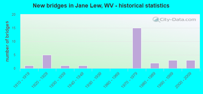
- New bridges - historical statistics
- 11910-1919
- 51920-1929
- 11930-1939
- 11940-1949
- 151970-1979
- 21980-1989
- 31990-1999
- 32000-2009
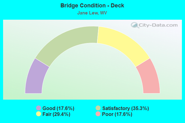
- Bridge Condition - Deck
- 17.6%Good
- 35.3%Satisfactory
- 29.4%Fair
- 17.6%Poor
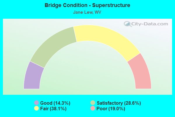
- Bridge Condition - Superstructure
- 14.3%Good
- 28.6%Satisfactory
- 38.1%Fair
- 19.0%Poor
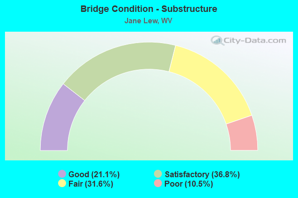
- Bridge Condition - Substructure
- 21.1%Good
- 36.8%Satisfactory
- 31.6%Fair
- 10.5%Poor
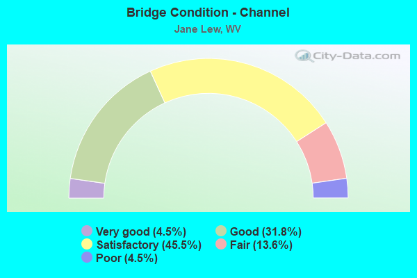
- Bridge Condition - Channel
- 4.5%Very good
- 31.8%Good
- 45.5%Satisfactory
- 13.6%Fair
- 4.5%Poor
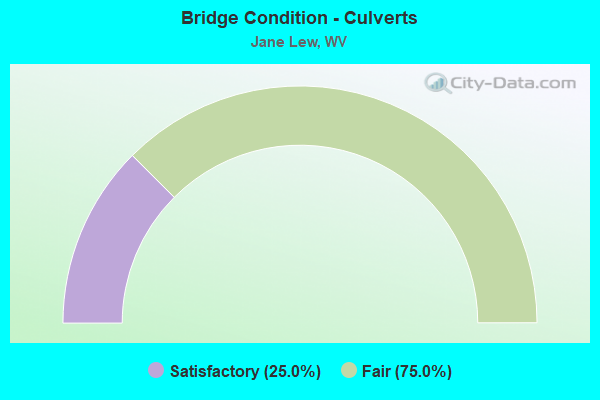
- Bridge Condition - Culverts
- 25.0%Satisfactory
- 75.0%Fair
Find on map >> Show street view
Structure Number: 17A067, Location: 0.01 MI NORTH CO RT 19/22 (Lat: 39.134461, Lng: -80.421550), Route carried "on" structure: US 1900, Year Built: 1983, Status: Open, Structure Length: 2.58m (8.46ft), Average Daily Traffic: 1,800 (year 2019), Truck Traffic: 10%, Average Future Daily Traffic: 2,230 (year 2041), Design Load: HS 20, Features Intersected: HACKERS CREEK, Facility Carried by Structure: US ROUTE 19
Minimum Vertical Clearance: 30+ m (98+ ft), Kilometerpoint: 0.354, Lanes on structure: 2, Owner: State Highway Agency, Approaching Roadway Width: 8.5m (27.9ft), Material/Design: Steel, Design/Construction: Stringer/Multi-beam, Number Of Spans In Main Unit: 1, Length of Maximum Span: 24.4m (80.1ft), Curb-To-Curb Width: 6.9m (22.6ft), Out-to-Out Width: 7.0m (23.0ft)
Condition: Deck: Poor, Superstructure: Fair, Substructure: Satisfactory, Channel: Very good, Operating Rating: 85.3 metric tons, Method Used To Determine Operating Rating: Load Factor (LF), Inventory Rating: 50.8 metric tons, Method Used To Determine Inventory Rating: Load Factor (LF), Structural Evaluation: Somewhat better than minimum adequacy, Deck Geometry: High priority of corrective action, Waterway Adequacy: Equal to present minimum criteria, Approach Roadway Alignment: Meets minimum limits, Length Of Structure Improvement: 3.38m (11.09ft), Designated Inspection Frequency: Every 24 months, Inspection Date: October 2021, Bridge Improvement Cost: $436,000, Roadway Improvement Cost: $382,000, Total Project Cost: $1,021,000 ( Estimate for 2022), Deck Structure Type: Closed Grating, Wearing Surface/Protective System: Wearing Surface: Bituminous
Find on map >> Show street view
Structure Number: 17A071, Location: 0.19 MI SOUTH CO RT 19/20 (Lat: 39.145219, Lng: -80.429069), Route carried "on" structure: US 1900, Year Built: 1924, Status: Open, Structure Length: 2.44m (8.01ft), Average Daily Traffic: 1,800 (year 2018), Truck Traffic: 7%, Average Future Daily Traffic: 2,350 (year 2038), Features Intersected: HACKERS CREEK, Facility Carried by Structure: US ROUTE 19
Minimum Vertical Clearance: 30+ m (98+ ft), Kilometerpoint: 2.237, Lanes on structure: 2, Owner: State Highway Agency, Approaching Roadway Width: 7.6m (24.9ft), Material/Design: Concrete, Design/Construction: Arch - Deck, Number Of Spans In Main Unit: 1, Length of Maximum Span: 24.4m (80.1ft), Curb or Sidewalk Widths: Left: 0.1m (0.3ft), Right: 0.1m (0.3ft), Curb-To-Curb Width: 6.7m (22.0ft), Out-to-Out Width: 7.6m (24.9ft)
Condition: Superstructure: Fair, Channel: Good, Operating Rating: 55.3 metric tons, Method Used To Determine Operating Rating: Field evaluation and documented engineering judgment, Inventory Rating: 21.8 metric tons, Method Used To Determine Inventory Rating: Field evaluation and documented engineering judgment, Structural Evaluation: Somewhat better than minimum adequacy, Deck Geometry: High priority of corrective action, Waterway Adequacy: Equal to present desirable criteria, Approach Roadway Alignment: Meets minimum limits, Length Of Structure Improvement: 3.35m (10.99ft), Designated Inspection Frequency: Every 24 months, Inspection Date: Febuary 2020, Bridge Improvement Cost: $504,000, Roadway Improvement Cost: $449,000, Total Project Cost: $971,000 ( Estimate for 2020)
Find on map >> Show street view
Structure Number: 17A188, Location: 0.04 MI WEST US RT 19 (Lat: 39.150689, Lng: -80.436231), Route carried "on" structure: County highway 3500, Year Built: 1940, Year Reconstructed: 1992, Status: Open, Structure Length: 6.56m (21.52ft), Average Daily Traffic: 600 (year 2018), Truck Traffic: 7%, Average Future Daily Traffic: 775 (year 2038), Design Load: HS 20, Features Intersected: WEST FORK RIVER, Facility Carried by Structure: HARRISON CO RT 35
Minimum Vertical Clearance: 30+ m (98+ ft), Kilometerpoint: 15.337, Lanes on structure: 2, Owner: State Highway Agency, Approaching Roadway Width: 7.6m (24.9ft), Material/Design: Steel continuous, Design/Construction: Stringer/Multi-beam, Number Of Spans In Main Unit: 1, Number Of Approach Spans: 2, Length of Maximum Span: 24.4m (80.1ft), Curb-To-Curb Width: 7.0m (23.0ft), Out-to-Out Width: 7.2m (23.6ft)
Condition: Deck: Poor, Superstructure: Fair, Substructure: Poor, Channel: Good, Operating Rating: 24.5 metric tons, Method Used To Determine Operating Rating: Load Factor (LF), Inventory Rating: 14.5 metric tons, Method Used To Determine Inventory Rating: Load Factor (LF), Structural Evaluation: Meets minimum limits, Deck Geometry: Meets minimum limits, Waterway Adequacy: Equal to present desirable criteria, Approach Roadway Alignment: Better than present minimum criteria, Length Of Structure Improvement: 7.32m (24.02ft), Designated Inspection Frequency: Every 24 months, Inspection Date: October 2020, Bridge Improvement Cost: $1,178,000, Roadway Improvement Cost: $657,000, Total Project Cost: $2,282,000 ( Estimate for 2021), Deck Structure Type: Closed Grating
Find on map >> Show street view
Structure Number: 21A004, Location: 0.06 MI S OF CO 1/3 SLS (Lat: 39.113931, Lng: -80.461861), Route carried "on" structure: County highway 100, Year Built: 1924, Status: Open, Structure Length: 0.91m (2.99ft), Average Daily Traffic: 1,800 (year 2015), Truck Traffic: 5%, Average Future Daily Traffic: 2,484 (year 2035), Features Intersected: MCCANN RUN, Facility Carried by Structure: COUNTY ROUTE 1 SLS
Minimum Vertical Clearance: 30+ m (98+ ft), Kilometerpoint: 10.445, Lanes on structure: 2, Owner: State Highway Agency, Approaching Roadway Width: 7.3m (24.0ft), Skew: 2 degrees, Material/Design: Concrete, Design/Construction: Arch - Deck, Number Of Spans In Main Unit: 1, Length of Maximum Span: 7.8m (25.6ft), Curb-To-Curb Width: 7.6m (24.9ft), Out-to-Out Width: 8.0m (26.2ft)
Condition: Superstructure: Fair, Substructure: Satisfactory, Channel: Satisfactory, Operating Rating: 63.5 metric tons, Method Used To Determine Operating Rating: Field evaluation and documented engineering judgment, Inventory Rating: 29.0 metric tons, Method Used To Determine Inventory Rating: Field evaluation and documented engineering judgment, Structural Evaluation: Somewhat better than minimum adequacy, Deck Geometry: Meets minimum limits, Waterway Adequacy: Superior to present desirable criteria, Approach Roadway Alignment: Equal to present desirable criteria, Length Of Structure Improvement: 0.91m (2.99ft), Designated Inspection Frequency: Every 24 months, Inspection Date: July 2020, Bridge Improvement Cost: $50,000, Total Project Cost: $50,000 ( Estimate for 2020)
Find on map >> Show street view
Structure Number: 21A005, Location: 0.02 MI N OF CO RT 1/1 (Lat: 39.140239, Lng: -80.456569), Route carried "on" structure: County highway 100, Year Built: 1924, Status: Open, Structure Length: 1.59m (5.22ft), Average Daily Traffic: 1,200 (year 2018), Truck Traffic: 10%, Average Future Daily Traffic: 1,370 (year 2038), Features Intersected: KINCHELOE CREEK, Facility Carried by Structure: COUNTY ROUTE 1 SLS
Minimum Vertical Clearance: 30+ m (98+ ft), Kilometerpoint: 14.178, Lanes on structure: 2, Owner: State Highway Agency, Approaching Roadway Width: 7.3m (24.0ft), Material/Design: Concrete, Design/Construction: Arch - Deck, Number Of Spans In Main Unit: 1, Length of Maximum Span: 15.3m (50.2ft), Curb or Sidewalk Widths: Left: 0.1m (0.3ft), Right: 0.1m (0.3ft), Curb-To-Curb Width: 5.5m (18.0ft), Out-to-Out Width: 6.1m (20.0ft)
Condition: Deck: Fair, Superstructure: Fair, Substructure: Satisfactory, Channel: Satisfactory, Operating Rating: 41.7 metric tons, Method Used To Determine Operating Rating: Field evaluation and documented engineering judgment, Inventory Rating: 17.2 metric tons, Method Used To Determine Inventory Rating: Field evaluation and documented engineering judgment, Structural Evaluation: Meets minimum limits, Deck Geometry: High priority of replacement, Waterway Adequacy: Superior to present desirable criteria, Approach Roadway Alignment: Equal to present minimum criteria, Length Of Structure Improvement: 2.23m (7.32ft), Designated Inspection Frequency: Every 24 months, Inspection Date: May 2021, Bridge Improvement Cost: $250,000, Roadway Improvement Cost: $250,000, Total Project Cost: $700,000 ( Estimate for 2021), Deck Structure Type: Concrete Cast-file-Place, Wearing Surface/Protective System: Wearing Surface: Bituminous
Find on map >> Show street view
Structure Number: 21A006, Location: 0.37 MI S OF CO 1 (Lat: 39.113261, Lng: -80.451919), Route carried "on" structure: County highway 102, Year Built: 1923, Status: Open, Structure Length: 0.68m (2.23ft), Average Daily Traffic: 100 (year 2018), Average Future Daily Traffic: 115 (year 2038), Features Intersected: MC CANN RUN, Facility Carried by Structure: COUNTY ROUTE 1/2
Minimum Vertical Clearance: 30+ m (98+ ft), Kilometerpoint: 0.595, Lanes on structure: 1, Owner: State Highway Agency, Approaching Roadway Width: 5.5m (18.0ft), Material/Design: Concrete, Design/Construction: Arch - Deck, Number Of Spans In Main Unit: 1, Length of Maximum Span: 6.8m (22.3ft), Curb-To-Curb Width: 4.3m (14.1ft), Out-to-Out Width: 4.3m (14.1ft)
Condition: Superstructure: Satisfactory, Substructure: Satisfactory, Channel: Fair, Operating Rating: 47.2 metric tons, Method Used To Determine Operating Rating: Field evaluation and documented engineering judgment, Inventory Rating: 21.8 metric tons, Method Used To Determine Inventory Rating: Field evaluation and documented engineering judgment, Structural Evaluation: Equal to present minimum criteria, Deck Geometry: Equal to present minimum criteria, Waterway Adequacy: Equal to present desirable criteria, Approach Roadway Alignment: Equal to present desirable criteria, Length Of Structure Improvement: 1.07m (3.51ft), Designated Inspection Frequency: Every 24 months, Inspection Date: January 2022, Bridge Improvement Cost: $120,000, Roadway Improvement Cost: $30,000, Total Project Cost: $180,000 ( Estimate for 2022)
Find on map >> Show street view
Structure Number: 21A013, Location: 0.35 MI S CO 7/6 (Lat: 39.063631, Lng: -80.368281), Route carried "on" structure: County highway 700, Year Built: 1918, Status: Posted for load, Structure Length: 1.10m (3.61ft), Average Daily Traffic: 850 (year 2018), Truck Traffic: 8%, Average Future Daily Traffic: 977 (year 2038), Features Intersected: BLOODY RUN, Facility Carried by Structure: COUNTY ROUTE 7
Minimum Vertical Clearance: 30+ m (98+ ft), Kilometerpoint: 1.207, Lanes on structure: 2, Owner: State Highway Agency, Approaching Roadway Width: 7.3m (24.0ft), Skew: 2 degrees, Material/Design: Concrete, Design/Construction: Slab, Number Of Spans In Main Unit: 1, Length of Maximum Span: 7.3m (24.0ft), Curb-To-Curb Width: 6.6m (21.7ft), Out-to-Out Width: 7.2m (23.6ft)
Condition: Deck: Fair, Superstructure: Fair, Substructure: Satisfactory, Channel: Satisfactory, Operating Rating: 31.7 metric tons, Method Used To Determine Operating Rating: Field evaluation and documented engineering judgment, Inventory Rating: 14.5 metric tons, Method Used To Determine Inventory Rating: Field evaluation and documented engineering judgment, Structural Evaluation: Meets minimum limits, Deck Geometry: High priority of corrective action, Waterway Adequacy: Equal to present minimum criteria, Approach Roadway Alignment: Equal to present desirable criteria, Bridge Posting: Required (Relationship of Operating Rating to Maximum Legal Load: 10.0 - 19.9% below), Length Of Structure Improvement: 1.52m (4.99ft), Designated Inspection Frequency: Every 24 months, Inspection Date: August 2021, Bridge Improvement Cost: $450,000, Roadway Improvement Cost: $250,000, Total Project Cost: $850,000 ( Estimate for 2021), Deck Structure Type: Concrete Cast-file-Place, Wearing Surface/Protective System: Wearing Surface: Bituminous
Find on map >> Show street view
Structure Number: 21A014, Location: 0.07 MI S CO 8 (Lat: 39.102489, Lng: -80.389961), Route carried "on" structure: County highway 700, Year Built: 1970, Status: Open, Structure Length: 1.03m (3.38ft), Average Daily Traffic: 1,800 (year 2018), Truck Traffic: 8%, Average Future Daily Traffic: 2,070 (year 2038), Features Intersected: JESSE RUN, Facility Carried by Structure: COUNTY ROUTE 7
Minimum Vertical Clearance: 30+ m (98+ ft), Kilometerpoint: 6.518, Lanes on structure: 2, Owner: State Highway Agency, Approaching Roadway Width: 13.4m (44.0ft), Skew: 3 degrees, Material/Design: Concrete continuous, Design/Construction: Culvert, Number Of Spans In Main Unit: 2, Length of Maximum Span: 5.0m (16.4ft)
Condition: Channel: Satisfactory, Culverts: Satisfactory, Operating Rating: 71.7 metric tons, Method Used To Determine Operating Rating: Field evaluation and documented engineering judgment, Inventory Rating: 32.7 metric tons, Method Used To Determine Inventory Rating: Field evaluation and documented engineering judgment, Structural Evaluation: Equal to present minimum criteria, Waterway Adequacy: Equal to present minimum criteria, Approach Roadway Alignment: Equal to present desirable criteria, Designated Inspection Frequency: Every 24 months, Inspection Date: November 2021
Find on map >> Show street view
Structure Number: 21A015, Location: 0.10 MI S OF CO RT 7/7 (Lat: 39.104311, Lng: -80.392061), Route carried "on" structure: County highway 700, Year Built: 1970, Status: Open, Structure Length: 8.05m (26.41ft), Average Daily Traffic: 9,700 (year 2018), Truck Traffic: 15%, Average Future Daily Traffic: 11,155 (year 2038), Design Load: HS 20+Mod, Features Intersected: CO 7 SLS, Facility Carried by Structure: COUNTY ROUTE 7 SLS
Minimum Vertical Clearance: 30+ m (98+ ft), Kilometerpoint: 6.872, Lanes on structure: 2, Lanes under structure: 4, Owner: State Highway Agency, Approaching Roadway Width: 12.8m (42.0ft), Skew: 2 degrees, Material/Design: Steel continuous, Design/Construction: Frame, Number Of Spans In Main Unit: 2, Number Of Approach Spans: 2, Length of Maximum Span: 26.2m (86.0ft), Curb or Sidewalk Widths: Left: 0.3m (1.0ft), Right: 0.3m (1.0ft), Curb-To-Curb Width: 12.2m (40.0ft), Out-to-Out Width: 13.4m (44.0ft)
Condition: Deck: Fair, Superstructure: Fair, Substructure: Satisfactory, Operating Rating: 48.1 metric tons, Method Used To Determine Operating Rating: Load Factor (LF), Inventory Rating: 28.1 metric tons, Method Used To Determine Inventory Rating: Load Factor (LF), Structural Evaluation: Somewhat better than minimum adequacy, Deck Geometry: Somewhat better than minimum adequacy, Underclear: Meets minimum limits, Approach Roadway Alignment: Equal to present desirable criteria, Length Of Structure Improvement: 8.05m (26.41ft), Designated Inspection Frequency: Every 24 months, Other Special Inspection Frequency: Every 12 months, Inspection Date: August 2021, Other Special Inspection Date: August 2021, Bridge Improvement Cost: $600,000, Roadway Improvement Cost: $50,000, Total Project Cost: $680,000 ( Estimate for 2021), Deck Structure Type: Concrete Cast-file-Place, Wearing Surface/Protective System: Wearing Surface: Latex Concrete
Find on map >> Show street view
Structure Number: 21A016, Location: 0.28 MI N CO 7/7 SLS (Lat: 39.106131, Lng: -80.399150), Route carried "on" structure: County highway 700, Year Built: 1970, Status: Open, Structure Length: 3.94m (12.93ft), Average Daily Traffic: 10,000 (year 2015), Truck Traffic: 6%, Average Future Daily Traffic: 1,340 (year 2035), Design Load: HS 20, Features Intersected: HACKERS CREEK, Facility Carried by Structure: COUNTY ROUTE 7
Minimum Vertical Clearance: 30+ m (98+ ft), Kilometerpoint: 7.483, Lanes on structure: 2, Owner: State Highway Agency, Approaching Roadway Width: 13.4m (44.0ft), Material/Design: Steel continuous, Design/Construction: Stringer/Multi-beam, Number Of Spans In Main Unit: 1, Number Of Approach Spans: 2, Length of Maximum Span: 14.6m (47.9ft), Curb or Sidewalk Widths: Left: 0.2m (0.7ft), Right: 0.2m (0.7ft), Curb-To-Curb Width: 11.7m (38.4ft), Out-to-Out Width: 13.0m (42.7ft)
Condition: Deck: Satisfactory, Superstructure: Good, Substructure: Good, Channel: Good, Operating Rating: 84.4 metric tons, Method Used To Determine Operating Rating: Load Factor (LF), Inventory Rating: 50.8 metric tons, Method Used To Determine Inventory Rating: Load Factor (LF), Structural Evaluation: Better than present minimum criteria, Deck Geometry: Somewhat better than minimum adequacy, Waterway Adequacy: Superior to present desirable criteria, Approach Roadway Alignment: Equal to present desirable criteria, Length Of Structure Improvement: 3.93m (12.89ft), Designated Inspection Frequency: Every 48 months, Underwater Inspection Frequency: Every 60 months, Inspection Date: June 2020, Underwater Inspection Date: July 2021, Bridge Improvement Cost: $150,000, Roadway Improvement Cost: $30,000, Total Project Cost: $220,000 ( Estimate for 2020), Deck Structure Type: Concrete Cast-file-Place, Wearing Surface/Protective System: Wearing Surface: Latex Concrete
Find on map >> Show street view
Structure Number: 21A017, Location: 0.46 MI W OF CO 7 (Lat: 39.070419, Lng: -80.383261), Route carried "on" structure: County highway 704, Year Built: 1980, Status: Open, Structure Length: 1.19m (3.90ft), Average Daily Traffic: 20 (year 2018), Truck Traffic: 5%, Average Future Daily Traffic: 27 (year 2038), Design Load: H 20, Features Intersected: HACKERS CREEK, Facility Carried by Structure: COUNTY ROUTE 7/4
Minimum Vertical Clearance: 30+ m (98+ ft), Kilometerpoint: 0.740, Lanes on structure: 1, Owner: State Highway Agency, Approaching Roadway Width: 5.5m (18.0ft), Material/Design: Steel continuous, Design/Construction: Stringer/Multi-beam, Number Of Spans In Main Unit: 2, Length of Maximum Span: 5.9m (19.4ft), Curb or Sidewalk Widths: Left: 0.2m (0.7ft), Right: 0.2m (0.7ft), Curb-To-Curb Width: 4.3m (14.1ft), Out-to-Out Width: 4.3m (14.1ft)
Condition: Deck: Satisfactory, Superstructure: Poor, Substructure: Poor, Channel: Fair, Operating Rating: 64.4 metric tons, Method Used To Determine Operating Rating: Load Factor (LF), Inventory Rating: 39.0 metric tons, Method Used To Determine Inventory Rating: Load Factor (LF), Structural Evaluation: Meets minimum limits, Deck Geometry: Equal to present minimum criteria, Waterway Adequacy: Meets minimum limits, Approach Roadway Alignment: Equal to present minimum criteria, Length Of Structure Improvement: 1.52m (4.99ft), Designated Inspection Frequency: Every 24 months, Inspection Date: November 2020, Bridge Improvement Cost: $150,000, Roadway Improvement Cost: $50,000, Total Project Cost: $250,000 ( Estimate for 2021), Deck Structure Type: Wood or Timber, Wearing Surface/Protective System: Wearing Surface: Bituminous
Find on map >> Show street view
Structure Number: 21A018, Location: 0.01 MI E CO 1 (Lat: 39.126619, Lng: -80.452100), Route carried "on" structure: County highway 800, Year Built: 1993, Status: Open, Structure Length: 3.69m (12.11ft), Average Daily Traffic: 1,100 (year 2018), Truck Traffic: 9%, Average Future Daily Traffic: 1,265 (year 2038), Design Load: HS 25 or greater, Features Intersected: WEST FORK RIVER, Facility Carried by Structure: COUNTY ROUTE 8 SLS
Minimum Vertical Clearance: 30+ m (98+ ft), Kilometerpoint: 0.016, Lanes on structure: 2, Owner: State Highway Agency, Approaching Roadway Width: 7.3m (24.0ft), Material/Design: Wood or Timber, Design/Construction: Tee Beam, Number Of Spans In Main Unit: 2, Length of Maximum Span: 17.7m (58.1ft), Curb-To-Curb Width: 5.9m (19.4ft), Out-to-Out Width: 6.4m (21.0ft)
Condition: Deck: Good, Superstructure: Fair, Substructure: Fair, Channel: Satisfactory, Operating Rating: 49.0 metric tons, Method Used To Determine Operating Rating: Allowable Stress (AS), Inventory Rating: 30.8 metric tons, Method Used To Determine Inventory Rating: Allowable Stress (AS), Structural Evaluation: Somewhat better than minimum adequacy, Deck Geometry: High priority of replacement, Waterway Adequacy: Superior to present desirable criteria, Approach Roadway Alignment: Better than present minimum criteria, Length Of Structure Improvement: 4.27m (14.01ft), Designated Inspection Frequency: Every 24 months, Underwater Inspection Frequency: Every 60 months, Other Special Inspection Frequency: Every 12 months, Inspection Date: July 2021, Underwater Inspection Date: July 2020, Other Special Inspection Date: April 2021, Bridge Improvement Cost: $260,000, Roadway Improvement Cost: $200,000, Total Project Cost: $565,000 ( Estimate for 2021), Deck Structure Type: Wood or Timber, Wearing Surface/Protective System: Wearing Surface: Bituminous
Find on map >> Show street view
Structure Number: 21A021, Location: 0.01 MI E CO 8 SLS (Lat: 39.102761, Lng: -80.378381), Route carried "on" structure: County highway 804, Year Built: 1996, Status: Open, Structure Length: 1.67m (5.48ft), Average Daily Traffic: 30 (year 2018), Average Future Daily Traffic: 35 (year 2038), Design Load: HS 25 or greater, Features Intersected: JESSE RUN, Facility Carried by Structure: COUNTY ROUTE 8/4
Minimum Vertical Clearance: 30+ m (98+ ft), Kilometerpoint: 0.016, Lanes on structure: 2, Owner: State Highway Agency, Approaching Roadway Width: 5.5m (18.0ft), Material/Design: Wood or Timber, Design/Construction: Tee Beam, Number Of Spans In Main Unit: 1, Length of Maximum Span: 15.5m (50.9ft), Curb or Sidewalk Widths: Left: 0.2m (0.7ft), Right: 0.2m (0.7ft), Curb-To-Curb Width: 7.3m (24.0ft), Out-to-Out Width: 7.7m (25.3ft)
Condition: Deck: Good, Superstructure: Satisfactory, Substructure: Good, Channel: Fair, Operating Rating: 45.4 metric tons, Method Used To Determine Operating Rating: Allowable Stress (AS), Inventory Rating: 29.0 metric tons, Method Used To Determine Inventory Rating: Allowable Stress (AS), Structural Evaluation: Equal to present minimum criteria, Deck Geometry: Equal to present minimum criteria, Waterway Adequacy: Somewhat better than minimum adequacy, Approach Roadway Alignment: Equal to present minimum criteria, Designated Inspection Frequency: Every 24 months, Other Special Inspection Frequency: Every 12 months, Inspection Date: July 2020, Other Special Inspection Date: July 2021, Deck Structure Type: Wood or Timber, Wearing Surface/Protective System: Wearing Surface: Bituminous
Find on map >> Show street view
Structure Number: 21A043, Location: 0.02 MI S CO 7 (Lat: 39.088969, Lng: -80.389219), Route carried "on" structure: County highway 1400, Year Built: 1937, Status: Open, Structure Length: 1.61m (5.28ft), Average Daily Traffic: 250 (year 2015), Truck Traffic: 5%, Average Future Daily Traffic: 275 (year 2035), Features Intersected: HACKERS CREEK, Facility Carried by Structure: COUNTY ROUTE 14
Minimum Vertical Clearance: 30+ m (98+ ft), Kilometerpoint: 9.753, Lanes on structure: 2, Owner: State Highway Agency, Approaching Roadway Width: 6.7m (22.0ft), Material/Design: Steel, Design/Construction: Stringer/Multi-beam, Number Of Spans In Main Unit: 1, Length of Maximum Span: 15.0m (49.2ft), Curb or Sidewalk Widths: Left: 0.3m (1.0ft), Right: 0.3m (1.0ft), Curb-To-Curb Width: 5.2m (17.1ft), Out-to-Out Width: 5.8m (19.0ft)
Condition: Deck: Poor, Superstructure: Poor, Substructure: Fair, Channel: Good, Operating Rating: 48.1 metric tons, Method Used To Determine Operating Rating: Load Factor (LF), Inventory Rating: 29.0 metric tons, Method Used To Determine Inventory Rating: Load Factor (LF), Structural Evaluation: Meets minimum limits, Deck Geometry: High priority of replacement, Waterway Adequacy: Equal to present desirable criteria, Approach Roadway Alignment: Equal to present minimum criteria, Length Of Structure Improvement: 2.29m (7.51ft), Designated Inspection Frequency: Every 24 months, Inspection Date: March 2020, Bridge Improvement Cost: $250,000, Roadway Improvement Cost: $247,000, Total Project Cost: $644,000 ( Estimate for 2020), Deck Structure Type: Concrete Cast-file-Place, Wearing Surface/Protective System: Wearing Surface: Bituminous
Find on map >> Show street view
Structure Number: 21A063, Location: 0.01 MI N OF CO 8 (Lat: 39.109511, Lng: -80.406661), Route carried "on" structure: US 1900, Year Built: 1924, Status: Open, Structure Length: 2.57m (8.43ft), Average Daily Traffic: 3,600 (year 2018), Truck Traffic: 14%, Average Future Daily Traffic: 4,100 (year 2038), Features Intersected: HACKERS CREEK, Facility Carried by Structure: US ROUTE 19 SLS
Minimum Vertical Clearance: 30+ m (98+ ft), Kilometerpoint: 50.582, Lanes on structure: 2, Owner: State Highway Agency, Approaching Roadway Width: 9.1m (29.9ft), Material/Design: Concrete, Design/Construction: Arch - Deck, Number Of Spans In Main Unit: 1, Length of Maximum Span: 24.4m (80.1ft), Curb or Sidewalk Widths: Left: 1.5m (4.9ft), Right: 0.0m, Curb-To-Curb Width: 6.9m (22.6ft), Out-to-Out Width: 6.9m (22.6ft)
Condition: Superstructure: Satisfactory, Channel: Satisfactory, Operating Rating: 55.3 metric tons, Method Used To Determine Operating Rating: Field evaluation and documented engineering judgment, Inventory Rating: 21.8 metric tons, Method Used To Determine Inventory Rating: Field evaluation and documented engineering judgment, Structural Evaluation: Somewhat better than minimum adequacy, Deck Geometry: High priority of replacement, Waterway Adequacy: Equal to present desirable criteria, Approach Roadway Alignment: Equal to present desirable criteria, Length Of Structure Improvement: 3.05m (10.01ft), Designated Inspection Frequency: Every 24 months, Inspection Date: November 2020, Bridge Improvement Cost: $500,000, Roadway Improvement Cost: $200,000, Total Project Cost: $1,000,000 ( Estimate for 2020)
Find on map >> Show street view
Structure Number: 21A128, Location: 0.90 MI S CO 7 (Lat: 39.091569, Lng: -80.393519), Route carried "on" structure: Interstate 7900, Year Built: 1971, Status: Open, Structure Length: 4.11m (13.48ft), Average Daily Traffic: 13,900 (year 2018), Truck Traffic: 21%, Average Future Daily Traffic: 19,877 (year 2038), Design Load: HS 20+Mod, Features Intersected: HACKERS CREEK, Facility Carried by Structure: I-79 NBL
Minimum Vertical Clearance: 30+ m (98+ ft), Kilometerpoint: 167.613, Lanes on structure: 2, Base Highway Network: Yes, Owner: State Highway Agency, Approaching Roadway Width: 14.0m (45.9ft), Material/Design: Steel continuous, Design/Construction: Stringer/Multi-beam, Number Of Spans In Main Unit: 1, Number Of Approach Spans: 2, Length of Maximum Span: 15.2m (49.9ft), Curb-To-Curb Width: 12.3m (40.4ft), Out-to-Out Width: 13.6m (44.6ft)
Condition: Deck: Satisfactory, Superstructure: Satisfactory, Substructure: Fair, Channel: Satisfactory, Operating Rating: 62.6 metric tons, Method Used To Determine Operating Rating: Load Factor (LF), Inventory Rating: 37.2 metric tons, Method Used To Determine Inventory Rating: Load Factor (LF), Structural Evaluation: Somewhat better than minimum adequacy, Deck Geometry: Better than present minimum criteria, Waterway Adequacy: Superior to present desirable criteria, Approach Roadway Alignment: Equal to present desirable criteria, Designated Inspection Frequency: Every 24 months, Inspection Date: December 2021, Deck Structure Type: Concrete Cast-file-Place, Wearing Surface/Protective System: Wearing Surface: Latex Concrete
Find on map >> Show street view
Structure Number: 21A129, Location: 0.90 MI S CO 7 (Lat: 39.091681, Lng: -80.393781), Route carried "on" structure: Interstate 7900, Year Built: 1971, Status: Open, Structure Length: 4.11m (13.48ft), Average Daily Traffic: 13,900 (year 2018), Truck Traffic: 21%, Average Future Daily Traffic: 19,877 (year 2038), Design Load: HS 20+Mod, Features Intersected: HACKERS CREEK, Facility Carried by Structure: I-79 S
Minimum Vertical Clearance: 30+ m (98+ ft), Kilometerpoint: 167.613, Lanes on structure: 2, Base Highway Network: Yes, Owner: State Highway Agency, Approaching Roadway Width: 14.0m (45.9ft), Material/Design: Steel continuous, Design/Construction: Stringer/Multi-beam, Number Of Spans In Main Unit: 1, Number Of Approach Spans: 2, Length of Maximum Span: 15.2m (49.9ft), Curb-To-Curb Width: 12.3m (40.4ft), Out-to-Out Width: 13.6m (44.6ft)
Condition: Deck: Satisfactory, Superstructure: Satisfactory, Substructure: Fair, Channel: Satisfactory, Operating Rating: 62.6 metric tons, Method Used To Determine Operating Rating: Load Factor (LF), Inventory Rating: 37.2 metric tons, Method Used To Determine Inventory Rating: Load Factor (LF), Structural Evaluation: Somewhat better than minimum adequacy, Deck Geometry: Better than present minimum criteria, Waterway Adequacy: Superior to present desirable criteria, Approach Roadway Alignment: Equal to present desirable criteria, Designated Inspection Frequency: Every 24 months, Inspection Date: December 2021, Deck Structure Type: Concrete Cast-file-Place, Wearing Surface/Protective System: Wearing Surface: Latex Concrete
Find on map >> Show street view
Structure Number: 21A13, Location: 0.36 MI S OF CO 7 (Lat: 39.101219, Lng: -80.392069), Route carried "on" structure: Interstate 7900, Year Built: 1970, Status: Open, Structure Length: 0.88m (2.89ft), Average Daily Traffic: 29,290 (year 2015), Truck Traffic: 27%, Average Future Daily Traffic: 43,065 (year 2035), Design Load: HS 20+Mod, Features Intersected: JESSE RUN, Facility Carried by Structure: I 79 & RAMPS
Minimum Vertical Clearance: 30+ m (98+ ft), Kilometerpoint: 168.482, Lanes on structure: 6, Base Highway Network: Yes, Owner: State Highway Agency, Approaching Roadway Width: 39.9m (130.9ft), Material/Design: Concrete continuous, Design/Construction: Culvert, Number Of Spans In Main Unit: 2, Length of Maximum Span: 4.3m (14.1ft)
Condition: Channel: Poor, Culverts: Fair, Operating Rating: 71.7 metric tons, Method Used To Determine Operating Rating: Field evaluation and documented engineering judgment, Inventory Rating: 32.7 metric tons, Method Used To Determine Inventory Rating: Field evaluation and documented engineering judgment, Structural Evaluation: Somewhat better than minimum adequacy, Waterway Adequacy: Equal to present minimum criteria, Approach Roadway Alignment: Equal to present desirable criteria, Designated Inspection Frequency: Every 24 months, Inspection Date: March 2020
Find on map >> Show street view
Structure Number: 21A132, Location: 1.27 MI N CO 7 (Lat: 39.122069, Lng: -80.386650), Route carried "on" structure: Interstate 7900, Year Built: 1970, Status: Open, Structure Length: 13.56m (44.49ft), Average Daily Traffic: 14,950 (year 2018), Truck Traffic: 21%, Average Future Daily Traffic: 21,379 (year 2038), Design Load: HS 20+Mod, Features Intersected: McKinney Run and Co 3, Facility Carried by Structure: I-79 NBL
Minimum Vertical Clearance: 30+ m (98+ ft), Kilometerpoint: 171.105, Lanes on structure: 2, Lanes under structure: 2, Base Highway Network: Yes, Owner: State Highway Agency, Approaching Roadway Width: 14.0m (45.9ft), Skew: 2 degrees, Material/Design: Steel continuous, Design/Construction: Stringer/Multi-beam, Number Of Spans In Main Unit: 1, Number Of Approach Spans: 5, Length of Maximum Span: 30.8m (101.0ft), Curb-To-Curb Width: 12.2m (40.0ft), Out-to-Out Width: 13.4m (44.0ft)
Condition: Deck: Fair, Superstructure: Poor, Substructure: Fair, Channel: Satisfactory, Operating Rating: 61.7 metric tons, Method Used To Determine Operating Rating: Load Factor (LF), Inventory Rating: 36.3 metric tons, Method Used To Determine Inventory Rating: Load Factor (LF), Structural Evaluation: Meets minimum limits, Deck Geometry: Better than present minimum criteria, Underclear: Somewhat better than minimum adequacy, Waterway Adequacy: Equal to present desirable criteria, Approach Roadway Alignment: Equal to present desirable criteria, Length Of Structure Improvement: 13.56m (44.49ft), Designated Inspection Frequency: Every 24 months, Other Special Inspection Frequency: Every 12 months, Inspection Date: December 2021, Other Special Inspection Date: December 2021, Bridge Improvement Cost: $6,000,000, Roadway Improvement Cost: $300,000, Total Project Cost: $7,500,000 ( Estimate for 2022), Deck Structure Type: Concrete Cast-file-Place, Wearing Surface/Protective System: Wearing Surface: Latex Concrete
Find on map >> Show street view
Structure Number: 21A133, Location: 1.27 MI N CO 7 (Lat: 39.122231, Lng: -80.386881), Route carried "on" structure: Interstate 7900, Year Built: 1971, Status: Open, Structure Length: 13.56m (44.49ft), Average Daily Traffic: 14,950 (year 2018), Truck Traffic: 21%, Average Future Daily Traffic: 21,378 (year 2038), Design Load: HS 20+Mod, Features Intersected: McKinney Run and Co 3, Facility Carried by Structure: I-79
Minimum Vertical Clearance: 30+ m (98+ ft), Kilometerpoint: 171.105, Lanes on structure: 2, Lanes under structure: 2, Base Highway Network: Yes, Owner: State Highway Agency, Approaching Roadway Width: 14.0m (45.9ft), Skew: 2 degrees, Material/Design: Steel continuous, Design/Construction: Stringer/Multi-beam, Number Of Spans In Main Unit: 1, Number Of Approach Spans: 5, Length of Maximum Span: 30.8m (101.0ft), Curb-To-Curb Width: 12.2m (40.0ft), Out-to-Out Width: 13.4m (44.0ft)
Condition: Deck: Fair, Superstructure: Poor, Substructure: Fair, Channel: Satisfactory, Operating Rating: 61.7 metric tons, Method Used To Determine Operating Rating: Load Factor (LF), Inventory Rating: 36.3 metric tons, Method Used To Determine Inventory Rating: Load Factor (LF), Structural Evaluation: Meets minimum limits, Deck Geometry: Better than present minimum criteria, Underclear: Somewhat better than minimum adequacy, Waterway Adequacy: Equal to present desirable criteria, Approach Roadway Alignment: Equal to present desirable criteria, Length Of Structure Improvement: 13.56m (44.49ft), Designated Inspection Frequency: Every 24 months, Other Special Inspection Frequency: Every 12 months, Inspection Date: December 2021, Other Special Inspection Date: December 2021, Bridge Improvement Cost: $6,000,000, Roadway Improvement Cost: $300,000, Total Project Cost: $7,500,000 ( Estimate for 2022), Deck Structure Type: Concrete Cast-file-Place, Wearing Surface/Protective System: Wearing Surface: Latex Concrete
Find on map >> Show street view
Structure Number: 21A162, Location: 2.73 MI S CO 7 (Lat: 39.067350, Lng: -80.403861), Route carried "on" structure: Interstate 7900, Year Built: 1971, Status: Open, Structure Length: 0.63m (2.07ft), Average Daily Traffic: 27,800 (year 2018), Truck Traffic: 21%, Average Future Daily Traffic: 39,750 (year 2038), Design Load: HS 20+Mod, Features Intersected: CO 14/1, Facility Carried by Structure: I-79 N & S
Minimum Vertical Clearance: 30+ m (98+ ft), Kilometerpoint: 164.668, Lanes on structure: 4, Lanes under structure: 1, Base Highway Network: Yes, Owner: State Highway Agency, Approaching Roadway Width: 23.8m (78.1ft), Skew: 30 degrees, Material/Design: Steel, Design/Construction: Culvert, Number Of Spans In Main Unit: 1, Length of Maximum Span: 6.2m (20.3ft)
Condition: Culverts: Fair, Operating Rating: 71.7 metric tons, Method Used To Determine Operating Rating: Field evaluation and documented engineering judgment, Inventory Rating: 32.7 metric tons, Method Used To Determine Inventory Rating: Field evaluation and documented engineering judgment, Structural Evaluation: Somewhat better than minimum adequacy, Underclear: High priority of corrective action, Approach Roadway Alignment: Superior to present desirable criteria, Length Of Structure Improvement: 0.61m (2.00ft), Designated Inspection Frequency: Every 24 months, Inspection Date: October 2021, Bridge Improvement Cost: $75,000, Roadway Improvement Cost: $15,000, Total Project Cost: $100,000 ( Estimate for 2021)
Find on map >> Show street view
Structure Number: 21A163, Location: 2.33 MI S CO 7 (Lat: 39.072850, Lng: -80.405289), Route carried "on" structure: Interstate 7900, Year Built: 1971, Status: Open, Structure Length: 0.62m (2.03ft), Average Daily Traffic: 27,800 (year 2018), Truck Traffic: 20%, Average Future Daily Traffic: 39,754 (year 2038), Design Load: HS 20+Mod, Features Intersected: County Route 14/6, Facility Carried by Structure: I-79 N & S
Minimum Vertical Clearance: 30+ m (98+ ft), Kilometerpoint: 165.312, Lanes on structure: 4, Lanes under structure: 2, Base Highway Network: Yes, Owner: State Highway Agency, Approaching Roadway Width: 23.8m (78.1ft), Skew: 30 degrees, Material/Design: Steel, Design/Construction: Culvert, Number Of Spans In Main Unit: 1, Length of Maximum Span: 6.2m (20.3ft)
Condition: Culverts: Fair, Operating Rating: 71.7 metric tons, Method Used To Determine Operating Rating: Field evaluation and documented engineering judgment, Inventory Rating: 32.7 metric tons, Method Used To Determine Inventory Rating: Field evaluation and documented engineering judgment, Structural Evaluation: Somewhat better than minimum adequacy, Underclear: High priority of corrective action, Approach Roadway Alignment: Superior to present desirable criteria, Length Of Structure Improvement: 0.61m (2.00ft), Designated Inspection Frequency: Every 24 months, Inspection Date: October 2021, Bridge Improvement Cost: $75,000, Roadway Improvement Cost: $15,000, Total Project Cost: $100,000 ( Estimate for 2021)
Find on map >> Show street view
Structure Number: 21A179, Location: 0.05 MI E CO RT 8/2 SLS (Lat: 39.127019, Lng: -80.441489), Route carried "on" structure: County highway 800, Year Built: 1997, Status: Open, Structure Length: 1.26m (4.13ft), Average Daily Traffic: 1,451 (year 2015), Truck Traffic: 5%, Average Future Daily Traffic: 1,653 (year 2035), Design Load: HS 25 or greater, Features Intersected: BROAD RUN, Facility Carried by Structure: COUNTY ROUTE 8 SLS
Minimum Vertical Clearance: 30+ m (98+ ft), Kilometerpoint: 1.127, Lanes on structure: 2, Owner: State Highway Agency, Approaching Roadway Width: 7.3m (24.0ft), Skew: 4 degrees, Material/Design: Prestressed concrete, Design/Construction: Box Beam or Girders - Multiple, Number Of Spans In Main Unit: 1, Length of Maximum Span: 11.0m (36.1ft), Curb-To-Curb Width: 8.0m (26.2ft), Out-to-Out Width: 8.4m (27.6ft)
Condition: Deck: Good, Superstructure: Good, Substructure: Good, Channel: Good, Operating Rating: 61.7 metric tons, Method Used To Determine Operating Rating: Load and Resistance Factor (LRFR), Inventory Rating: 47.2 metric tons, Method Used To Determine Inventory Rating: Load and Resistance Factor (LRFR), Structural Evaluation: Better than present minimum criteria, Deck Geometry: Meets minimum limits, Waterway Adequacy: Equal to present desirable criteria, Approach Roadway Alignment: Equal to present desirable criteria, Designated Inspection Frequency: Every 48 months, Inspection Date: November 2019, Deck Structure Type: Other, Wearing Surface/Protective System: Wearing Surface: Bituminous, Deck Protection: Epoxy Coated Reinforcing
Find on map >> Show street view
Structure Number: 21A192, Location: 0.08 MI W US 19 (Lat: 39.109000, Lng: -80.408061), Route carried "on" structure: County highway 800, Year Built: 2004, Status: Open, Structure Length: 1.30m (4.27ft), Average Daily Traffic: 2,680 (year 2015), Truck Traffic: 5%, Average Future Daily Traffic: 3,592 (year 2035), Design Load: HS 25 or greater, Features Intersected: WEST RUN, Facility Carried by Structure: COUNTY ROUTE 8
Minimum Vertical Clearance: 30+ m (98+ ft), Kilometerpoint: 5.086, Lanes on structure: 2, Owner: State Highway Agency, Approaching Roadway Width: 6.1m (20.0ft), Skew: 3 degrees, Material/Design: Prestressed concrete, Design/Construction: Box Beam or Girders - Multiple, Number Of Spans In Main Unit: 1, Length of Maximum Span: 11.6m (38.1ft), Curb or Sidewalk Widths: Left: 0.0m, Right: 1.2m (3.9ft), Curb-To-Curb Width: 8.0m (26.2ft), Out-to-Out Width: 9.3m (30.5ft)
Condition: Deck: Satisfactory, Superstructure: Satisfactory, Substructure: Satisfactory, Channel: Good, Operating Rating: 61.7 metric tons, Method Used To Determine Operating Rating: Load and Resistance Factor (LRFR), Inventory Rating: 47.2 metric tons, Method Used To Determine Inventory Rating: Load and Resistance Factor (LRFR), Structural Evaluation: Equal to present minimum criteria, Deck Geometry: High priority of corrective action, Waterway Adequacy: Superior to present desirable criteria, Approach Roadway Alignment: Equal to present desirable criteria, Designated Inspection Frequency: Every 24 months, Inspection Date: August 2020, Deck Structure Type: Other, Wearing Surface/Protective System: Wearing Surface: Bituminous, Deck Protection: Epoxy Coated Reinforcing
Find on map >> Show street view
Structure Number: 21A193, Location: 0.06 MI WEST US 19 (Lat: 39.107711, Lng: -80.408400), Route carried "on" structure: County highway 1952, Year Built: 2007, Status: Open, Structure Length: 1.06m (3.48ft), Average Daily Traffic: 30 (year 2018), Average Future Daily Traffic: 35 (year 2038), Features Intersected: WEST RUN, Facility Carried by Structure: COUNTY ROUT 19/52
Minimum Vertical Clearance: 30+ m (98+ ft), Kilometerpoint: 0.097, Lanes on structure: 1, Owner: State Highway Agency, Approaching Roadway Width: 4.9m (16.1ft), Skew: 2 degrees, Material/Design: Steel, Design/Construction: Stringer/Multi-beam, Number Of Spans In Main Unit: 1, Length of Maximum Span: 10.3m (33.8ft), Curb-To-Curb Width: 4.5m (14.8ft), Out-to-Out Width: 4.5m (14.8ft)
Condition: Deck: Satisfactory, Superstructure: Good, Substructure: Good, Channel: Good, Operating Rating: 78.0 metric tons, Method Used To Determine Operating Rating: Load Factor (LF), Inventory Rating: 46.3 metric tons, Method Used To Determine Inventory Rating: Load Factor (LF), Structural Evaluation: Better than present minimum criteria, Deck Geometry: Equal to present minimum criteria, Waterway Adequacy: Equal to present minimum criteria, Approach Roadway Alignment: Equal to present desirable criteria, Designated Inspection Frequency: Every 48 months, Inspection Date: August 2021, Deck Structure Type: Wood or Timber
Find on map >> Show street view
Structure Number: 21A015, Location: 0.10 MI S OF CO RT 7/7 (Lat: 39.104300, Lng: -80.392019), Route carried "under" structure: Interstate 7900, Year Built: 1970, Structure Length: 0. m, Average Daily Traffic: 25,000 (year 0009), Truck Traffic: 20%, Features Intersected: CO 7 SLS, Facility Carried by Structure: COUNTY ROUTE 7 SLS
Minimum Vertical Clearance: 5.00m (16.40ft), Kilometerpoint: 169.062, Lanes on structure: 2, Lanes under structure: 4, Length of Maximum Span: 26.2m (86.0ft)
Find on map >> Show street view
Structure Number: 21A132, Location: 1.27 MI N CO 7 (Lat: 39.122069, Lng: -80.386650), Route carried "under" structure: County highway 300, Year Built: 1970, Structure Length: 0. m, Average Daily Traffic: 950 (year 0009), Truck Traffic: 5%, Features Intersected: McKinney Run and Co 3, Facility Carried by Structure: I-79 NBL
Minimum Vertical Clearance: 9.14m (29.99ft), Kilometerpoint: 2.076, Lanes on structure: 2, Lanes under structure: 2, Length of Maximum Span: 30.8m (101.0ft)
Find on map >> Show street view
Structure Number: 21A133, Location: 1.27 MI N CO 7 (Lat: 39.122231, Lng: -80.386881), Route carried "under" structure: County highway 300, Year Built: 1971, Structure Length: 0. m, Average Daily Traffic: 950 (year 0009), Truck Traffic: 5%, Features Intersected: McKinney Run and Co 3, Facility Carried by Structure: I-79
Minimum Vertical Clearance: 9.17m (30.09ft), Kilometerpoint: 2.076, Lanes on structure: 2, Lanes under structure: 2, Length of Maximum Span: 30.8m (101.0ft)
Find on map >> Show street view
Structure Number: 21A162, Location: 2.73 MI S CO 7 (Lat: 39.067350, Lng: -80.403861), Route carried "under" structure: County highway 1401, Year Built: 1971, Structure Length: 0. m, Average Daily Traffic: 10 (year 0006), Features Intersected: CO 14/1, Facility Carried by Structure: I-79 N & S
Minimum Vertical Clearance: 3.48m (11.42ft), Kilometerpoint: 0.048, Lanes on structure: 4, Lanes under structure: 1, Length of Maximum Span: 6.2m (20.3ft)
Find on map >> Show street view
Structure Number: 21A163, Location: 2.33 MI S CO 7 (Lat: 39.072850, Lng: -80.405289), Route carried "under" structure: County highway 1406, Year Built: 1971, Structure Length: 0. m, Average Daily Traffic: 10 (year 0006), Features Intersected: County Route 14/6, Facility Carried by Structure: I-79 N & S
Minimum Vertical Clearance: 3.38m (11.09ft), Kilometerpoint: 0.048, Lanes on structure: 4, Lanes under structure: 1, Length of Maximum Span: 6.2m (20.3ft)
Find on map >> Show street view
Structure Number: 25A26, Location: 0.68 MI NORTH MRN CO 64/2 (Lat: 39.136600, Lng: -80.464300), Route carried "under" structure: County highway 6400, Year Built: 2008, Structure Length: 0. m, Average Daily Traffic: 2,100 (year 0018), Truck Traffic: 9%, Features Intersected: Mar. Co. Rt. 64, Facility Carried by Structure: INTERSTATE 79
Minimum Vertical Clearance: 4.60m (15.09ft), Kilometerpoint: 5.263, Lanes on structure: 6, Lanes under structure: 2, Length of Maximum Span: 25.0m (82.0ft)