Bridge Statistics for Jefferson, Iowa (IA)
Condition, Traffic, Stress, Structural Evaluation, Project Costs
- National Bridge Inventory (NBI) Statistics
- 25Number of bridges
- 482ft / 147mTotal length
- 26,365Total average daily traffic
- 4,697Total average daily truck traffic
- National Bridge Inventory (NBI) Registered Bridges for Jefferson
- No street view available for this location
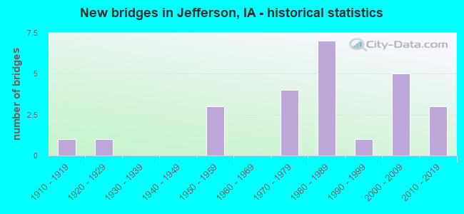
- New bridges - historical statistics
- 11910-1919
- 11920-1929
- 31950-1959
- 41970-1979
- 71980-1989
- 11990-1999
- 52000-2009
- 32010-2019

- Reconstructed bridges - Historical Statistics
- 11970-1979
- 11980-1989
- 01990-1999
- 12000-2009


- Bridge Condition - Deck
- 21.7%Very good
- 43.5%Good
- 30.4%Satisfactory
- 4.3%Fair

- Bridge Condition - Superstructure
- 34.8%Very good
- 34.8%Good
- 26.1%Satisfactory
- 4.3%Fair

- Bridge Condition - Substructure
- 21.7%Very good
- 52.2%Good
- 13.0%Satisfactory
- 13.0%Fair

- Bridge Condition - Channel
- 8.7%Very good
- 34.8%Good
- 39.1%Satisfactory
- 17.4%Fair
Find on map >> Show street view
Structure Number: 25611, Location: 3.8 Mi. W of IA 4 (Lat: 42.034572, Lng: -94.473528), Route carried "on" structure: US 30, Year Built: 2010, Status: Open, Structure Length: 11.86m (38.91ft), Average Daily Traffic: 2,950 (year 2020), Truck Traffic: 20%, Average Future Daily Traffic: 2,950 (year 2041), Design Load: HS 20, Features Intersected: NORTH RACCOON RIVER
Minimum Vertical Clearance: 30+ m (98+ ft), Kilometerpoint: 166.187, Lanes on structure: 2, Base Highway Network: Yes, Owner: State Highway Agency, Approaching Roadway Width: 15.8m (51.8ft), Material/Design: Prestressed concrete, Design/Construction: Stringer/Multi-beam, Number Of Spans In Main Unit: 3, Length of Maximum Span: 31.1m (102.0ft), Curb-To-Curb Width: 14.0m (45.9ft), Out-to-Out Width: 15.0m (49.2ft)
Condition: Deck: Good, Superstructure: Good, Substructure: Good, Channel: Good, Operating Rating: 90.1 metric tons, Method Used To Determine Operating Rating: Load Factor (LF), Inventory Rating: 73.6 metric tons, Method Used To Determine Inventory Rating: Load Factor (LF), Structural Evaluation: Better than present minimum criteria, Deck Geometry: Superior to present desirable criteria, Waterway Adequacy: Superior to present desirable criteria, Approach Roadway Alignment: Equal to present desirable criteria, Designated Inspection Frequency: Every 24 months, Inspection Date: November 2021, Deck Structure Type: Concrete Cast-file-Place, Wearing Surface/Protective System: Wearing Surface: Monolithic Concrete, Deck Protection: Epoxy Coated Reinforcing
Find on map >> Show street view
Structure Number: 2562, Location: 1.8 MI. E OF JCT. IA 4 (Lat: 42.034567, Lng: -94.343347), Route carried "on" structure: US 30, Year Built: 1957, Status: Open, Structure Length: 6.00m (19.69ft), Average Daily Traffic: 3,840 (year 2020), Truck Traffic: 17%, Average Future Daily Traffic: 3,840 (year 2040), Design Load: H 20, Features Intersected: HARDIN CREEK
Minimum Vertical Clearance: 30+ m (98+ ft), Kilometerpoint: 176.963, Lanes on structure: 2, Base Highway Network: Yes, Owner: State Highway Agency, Approaching Roadway Width: 13.4m (44.0ft), Material/Design: Concrete continuous, Design/Construction: Slab, Number Of Spans In Main Unit: 5, Length of Maximum Span: 12.8m (42.0ft), Curb-To-Curb Width: 8.5m (27.9ft), Out-to-Out Width: 10.6m (34.8ft)
Condition: Deck: Satisfactory, Superstructure: Satisfactory, Substructure: Fair, Channel: Satisfactory, Operating Rating: 57.9 metric tons, Method Used To Determine Operating Rating: Load Factor (LF), Inventory Rating: 34.7 metric tons, Method Used To Determine Inventory Rating: Load Factor (LF), Structural Evaluation: Somewhat better than minimum adequacy, Deck Geometry: Meets minimum limits, Waterway Adequacy: Equal to present minimum criteria, Approach Roadway Alignment: Equal to present desirable criteria, Designated Inspection Frequency: Every 24 months, Inspection Date: July 2020, Deck Structure Type: Concrete Cast-file-Place, Wearing Surface/Protective System: Wearing Surface: Low Slump Concrete
Find on map >> Show street view
Structure Number: 25681, Location: 1.9 mi S of Jct SR E53 (Lat: 41.987847, Lng: -94.377211), Route carried "on" structure: State highway 4, Year Built: 1983, Status: Open, Structure Length: 10.67m (35.01ft), Average Daily Traffic: 1,990 (year 2020), Truck Traffic: 14%, Average Future Daily Traffic: 1,990 (year 2040), Design Load: HS 20, Features Intersected: NORTH RACCOON RIVER
Minimum Vertical Clearance: 30+ m (98+ ft), Kilometerpoint: 33.457, Lanes on structure: 2, Base Highway Network: Yes, Owner: State Highway Agency, Approaching Roadway Width: 13.4m (44.0ft), Material/Design: Prestressed concrete, Design/Construction: Stringer/Multi-beam, Number Of Spans In Main Unit: 4, Length of Maximum Span: 26.5m (86.9ft), Curb-To-Curb Width: 12.2m (40.0ft), Out-to-Out Width: 13.2m (43.3ft)
Condition: Deck: Satisfactory, Superstructure: Very good, Substructure: Good, Channel: Satisfactory, Operating Rating: 85.1 metric tons, Method Used To Determine Operating Rating: Load Factor (LF), Inventory Rating: 50.9 metric tons, Method Used To Determine Inventory Rating: Load Factor (LF), Structural Evaluation: Better than present minimum criteria, Deck Geometry: Better than present minimum criteria, Waterway Adequacy: Equal to present desirable criteria, Approach Roadway Alignment: Better than present minimum criteria, Designated Inspection Frequency: Every 24 months, Inspection Date: June 2020, Deck Structure Type: Concrete Cast-file-Place, Wearing Surface/Protective System: Wearing Surface: Monolithic Concrete, Deck Protection: Epoxy Coated Reinforcing
Find on map >> Show street view
Structure Number: 25691, Location: 1.2 MI. N OF JCT.30 (Lat: 42.051672, Lng: -94.378111), Route carried "on" structure: State highway 4, Year Built: 1978, Status: Open, Structure Length: 4.08m (13.39ft), Average Daily Traffic: 2,450 (year 2020), Truck Traffic: 9%, Average Future Daily Traffic: 2,450 (year 2041), Design Load: HS 20, Features Intersected: HARDIN CREEK
Minimum Vertical Clearance: 30+ m (98+ ft), Kilometerpoint: 40.544, Lanes on structure: 2, Base Highway Network: Yes, Owner: State Highway Agency, Approaching Roadway Width: 13.4m (44.0ft), Skew: 3 degrees, Material/Design: Concrete continuous, Design/Construction: Slab, Number Of Spans In Main Unit: 3, Length of Maximum Span: 15.5m (50.9ft), Curb-To-Curb Width: 13.4m (44.0ft), Out-to-Out Width: 14.4m (47.2ft)
Condition: Deck: Satisfactory, Superstructure: Satisfactory, Substructure: Good, Channel: Good, Operating Rating: 64.9 metric tons, Method Used To Determine Operating Rating: Load Factor (LF), Inventory Rating: 39.0 metric tons, Method Used To Determine Inventory Rating: Load Factor (LF), Structural Evaluation: Equal to present minimum criteria, Deck Geometry: Better than present minimum criteria, Waterway Adequacy: Equal to present minimum criteria, Approach Roadway Alignment: Equal to present desirable criteria, Designated Inspection Frequency: Every 24 months, Inspection Date: November 2021, Deck Structure Type: Concrete Cast-file-Place, Wearing Surface/Protective System: Wearing Surface: Low Slump Concrete
Find on map >> Show street view
Structure Number: 162081, Location: 083300403 (Lat: 42.029692, Lng: -94.348867), Route carried "on" structure: County highway , Year Built: 1987, Status: Open, Structure Length: 4.24m (13.91ft), Average Daily Traffic: 60 (year 2012), Truck Traffic: 20%, Average Future Daily Traffic: 60 (year 2040), Design Load: HS 20, Features Intersected: HARDIN CREEK, Facility Carried by Structure: 222 ND
Minimum Vertical Clearance: 30+ m (98+ ft), Kilometerpoint: 0.618, Lanes on structure: 2, Owner: County Highway Agency, Approaching Roadway Width: 7.3m (24.0ft), Material/Design: Concrete continuous, Design/Construction: Slab, Number Of Spans In Main Unit: 4, Length of Maximum Span: 11.9m (39.0ft), Curb-To-Curb Width: 7.6m (24.9ft), Out-to-Out Width: 8.3m (27.2ft)
Condition: Deck: Good, Superstructure: Good, Substructure: Good, Channel: Satisfactory, Operating Rating: 79.5 metric tons, Method Used To Determine Operating Rating: Load Factor (LF), Inventory Rating: 47.6 metric tons, Method Used To Determine Inventory Rating: Load Factor (LF), Structural Evaluation: Better than present minimum criteria, Deck Geometry: Equal to present minimum criteria, Waterway Adequacy: Equal to present desirable criteria, Approach Roadway Alignment: Equal to present desirable criteria, Designated Inspection Frequency: Every 24 months, Inspection Date: June 2020, Deck Structure Type: Concrete Cast-file-Place, Wearing Surface/Protective System: Wearing Surface: Monolithic Concrete
Find on map >> Show street view
Structure Number: 162091, Location: 083301004 (Lat: 42.021761, Lng: -94.333897), Route carried "on" structure: County highway , Year Built: 1979, Status: Posted for load, Structure Length: 2.38m (7.81ft), Average Daily Traffic: 60 (year 2016), Truck Traffic: 50%, Average Future Daily Traffic: 60 (year 2040), Features Intersected: HARDIN CREEK, Facility Carried by Structure: PARKLAND AVE
Minimum Vertical Clearance: 30+ m (98+ ft), Kilometerpoint: 0.734, Lanes on structure: 2, Owner: County Highway Agency, Approaching Roadway Width: 7.3m (24.0ft), Material/Design: Steel, Design/Construction: Stringer/Multi-beam, Number Of Spans In Main Unit: 3, Length of Maximum Span: 7.9m (25.9ft), Curb-To-Curb Width: 7.0m (23.0ft), Out-to-Out Width: 7.3m (24.0ft)
Condition: Deck: Satisfactory, Superstructure: Satisfactory, Substructure: Fair, Channel: Fair, Operating Rating: 23.8 metric tons, Method Used To Determine Operating Rating: Load Factor (LF), Inventory Rating: 11.8 metric tons, Method Used To Determine Inventory Rating: Load Factor (LF), Structural Evaluation: Meets minimum limits, Deck Geometry: Somewhat better than minimum adequacy, Waterway Adequacy: Equal to present minimum criteria, Approach Roadway Alignment: Equal to present desirable criteria, Bridge Posting: Required (Relationship of Operating Rating to Maximum Legal Load: > 39.9% below), Length Of Structure Improvement: 10.60m (34.78ft), Designated Inspection Frequency: Every 24 months, Inspection Date: June 2020, Bridge Improvement Cost: $173,000, Roadway Improvement Cost: $26,000, Deck Structure Type: Wood or Timber, Wearing Surface/Protective System: Wearing Surface: Gravel
Find on map >> Show street view
Structure Number: 162101, Location: 083301005 (Lat: 42.015114, Lng: -94.325497), Route carried "on" structure: County highway , Year Built: 1993, Status: Open, Structure Length: 5.36m (17.59ft), Average Daily Traffic: 1,050 (year 2016), Truck Traffic: 9%, Average Future Daily Traffic: 1,050 (year 2040), Design Load: HS 20, Features Intersected: HARDIN CREEK, Facility Carried by Structure: 235 TH / E53
Minimum Vertical Clearance: 30+ m (98+ ft), Kilometerpoint: 2.699, Lanes on structure: 2, Owner: County Highway Agency, Approaching Roadway Width: 10.4m (34.1ft), Material/Design: Prestressed concrete, Design/Construction: Stringer/Multi-beam, Number Of Spans In Main Unit: 3, Length of Maximum Span: 19.8m (65.0ft), Curb-To-Curb Width: 9.3m (30.5ft), Out-to-Out Width: 10.1m (33.1ft)
Condition: Deck: Good, Superstructure: Very good, Substructure: Very good, Channel: Good, Operating Rating: 80.6 metric tons, Method Used To Determine Operating Rating: Load Factor (LF), Inventory Rating: 48.3 metric tons, Method Used To Determine Inventory Rating: Load Factor (LF), Structural Evaluation: Equal to present desirable criteria, Deck Geometry: Somewhat better than minimum adequacy, Waterway Adequacy: Equal to present desirable criteria, Approach Roadway Alignment: Equal to present desirable criteria, Designated Inspection Frequency: Every 24 months, Inspection Date: June 2020, Deck Structure Type: Concrete Cast-file-Place, Wearing Surface/Protective System: Wearing Surface: Monolithic Concrete
Find on map >> Show street view
Structure Number: 162131, Location: 083301405 (Lat: 41.998464, Lng: -94.319328), Route carried "on" structure: County highway , Year Built: 2009, Status: Open, Structure Length: 4.36m (14.30ft), Average Daily Traffic: 25 (year 2016), Average Future Daily Traffic: 25 (year 2040), Design Load: HS 20, Features Intersected: HARDIN CREEK, Facility Carried by Structure: 243 RD
Minimum Vertical Clearance: 30+ m (98+ ft), Kilometerpoint: 2.369, Lanes on structure: 2, Owner: County Highway Agency, Approaching Roadway Width: 7.3m (24.0ft), Material/Design: Concrete continuous, Design/Construction: Slab, Number Of Spans In Main Unit: 3, Length of Maximum Span: 16.8m (55.1ft), Curb-To-Curb Width: 7.5m (24.6ft), Out-to-Out Width: 7.5m (24.6ft)
Condition: Deck: Very good, Superstructure: Very good, Substructure: Very good, Channel: Very good, Operating Rating: 76.7 metric tons, Method Used To Determine Operating Rating: Load Factor (LF), Inventory Rating: 46.1 metric tons, Method Used To Determine Inventory Rating: Load Factor (LF), Structural Evaluation: Equal to present desirable criteria, Deck Geometry: Equal to present minimum criteria, Waterway Adequacy: Equal to present desirable criteria, Approach Roadway Alignment: Equal to present desirable criteria, Designated Inspection Frequency: Every 24 months, Inspection Date: June 2020, Deck Structure Type: Concrete Cast-file-Place, Wearing Surface/Protective System: Wearing Surface: Monolithic Concrete
Find on map >> Show street view
Structure Number: 162151, Location: 083301806 (Lat: 41.994244, Lng: -94.391106), Route carried "on" structure: County highway , Year Built: 1980, Status: Open, Structure Length: 0.70m (2.30ft), Average Daily Traffic: 15 (year 2012), Average Future Daily Traffic: 15 (year 2040), Features Intersected: SMALL STREAM, Facility Carried by Structure: MEADOW AVE
Minimum Vertical Clearance: 30+ m (98+ ft), Kilometerpoint: 0.652, Lanes on structure: 2, Owner: County Highway Agency, Approaching Roadway Width: 7.3m (24.0ft), Material/Design: Steel, Design/Construction: Stringer/Multi-beam, Number Of Spans In Main Unit: 1, Length of Maximum Span: 6.7m (22.0ft), Curb-To-Curb Width: 6.8m (22.3ft), Out-to-Out Width: 7.2m (23.6ft)
Condition: Deck: Satisfactory, Superstructure: Satisfactory, Substructure: Satisfactory, Channel: Satisfactory, Operating Rating: 51.7 metric tons, Method Used To Determine Operating Rating: Load Factor (LF), Inventory Rating: 30.8 metric tons, Method Used To Determine Inventory Rating: Load Factor (LF), Structural Evaluation: Equal to present minimum criteria, Deck Geometry: Somewhat better than minimum adequacy, Waterway Adequacy: Better than present minimum criteria, Approach Roadway Alignment: Equal to present desirable criteria, Length Of Structure Improvement: 2.40m (7.87ft), Designated Inspection Frequency: Every 24 months, Inspection Date: June 2020, Bridge Improvement Cost: $19,000, Roadway Improvement Cost: $2,000, Deck Structure Type: Wood or Timber, Wearing Surface/Protective System: Wearing Surface: Gravel
Find on map >> Show street view
Structure Number: 162161, Location: 083302203 (Lat: 41.986331, Lng: -94.323150), Route carried "on" structure: County highway , Year Built: 1981, Status: Open, Structure Length: 3.81m (12.50ft), Average Daily Traffic: 35 (year 2012), Average Future Daily Traffic: 35 (year 2040), Design Load: H 20, Features Intersected: HARDIN CREEK, Facility Carried by Structure: 255 TH
Minimum Vertical Clearance: 30+ m (98+ ft), Kilometerpoint: 1.249, Lanes on structure: 2, Owner: County Highway Agency, Approaching Roadway Width: 7.0m (23.0ft), Material/Design: Concrete continuous, Design/Construction: Slab, Number Of Spans In Main Unit: 3, Length of Maximum Span: 14.9m (48.9ft), Curb-To-Curb Width: 8.5m (27.9ft), Out-to-Out Width: 9.0m (29.5ft)
Condition: Deck: Good, Superstructure: Good, Substructure: Good, Channel: Satisfactory, Operating Rating: 50.8 metric tons, Method Used To Determine Operating Rating: Load Factor (LF), Inventory Rating: 30.4 metric tons, Method Used To Determine Inventory Rating: Load Factor (LF), Structural Evaluation: Better than present minimum criteria, Deck Geometry: Better than present minimum criteria, Waterway Adequacy: Better than present minimum criteria, Approach Roadway Alignment: Equal to present desirable criteria, Designated Inspection Frequency: Every 24 months, Inspection Date: June 2020, Deck Structure Type: Concrete Cast-file-Place, Wearing Surface/Protective System: Wearing Surface: Monolithic Concrete
Find on map >> Show street view
Structure Number: 1622, Location: 083310304 (Lat: 42.028231, Lng: -94.455400), Route carried "on" structure: County highway , Year Built: 1952, Year Reconstructed: 1981, Status: Open, Structure Length: 10.45m (34.28ft), Average Daily Traffic: 200 (year 2016), Truck Traffic: 19%, Average Future Daily Traffic: 200 (year 2040), Design Load: H 15, Features Intersected: RACCOON RIVER, Facility Carried by Structure: J AVE / P14
Minimum Vertical Clearance: 30+ m (98+ ft), Kilometerpoint: 18.319, Lanes on structure: 2, Owner: County Highway Agency, Approaching Roadway Width: 10.4m (34.1ft), Material/Design: Concrete continuous, Design/Construction: Tee Beam, Number Of Spans In Main Unit: 4, Length of Maximum Span: 30.2m (99.1ft), Curb-To-Curb Width: 6.2m (20.3ft), Out-to-Out Width: 6.7m (22.0ft)
Condition: Deck: Satisfactory, Superstructure: Fair, Substructure: Satisfactory, Channel: Satisfactory, Operating Rating: 33.0 metric tons, Method Used To Determine Operating Rating: Load Factor (LF), Inventory Rating: 19.8 metric tons, Method Used To Determine Inventory Rating: Load Factor (LF), Structural Evaluation: Somewhat better than minimum adequacy, Deck Geometry: Meets minimum limits, Waterway Adequacy: Better than present minimum criteria, Approach Roadway Alignment: Equal to present desirable criteria, Length Of Structure Improvement: 37.30m (122.38ft), Designated Inspection Frequency: Every 24 months, Inspection Date: July 2020, Bridge Improvement Cost: $804,000, Roadway Improvement Cost: $161,000, Deck Structure Type: Concrete Cast-file-Place, Wearing Surface/Protective System: Wearing Surface: Low Slump Concrete
Find on map >> Show street view
Structure Number: 16226, Location: 083311109 (Lat: 42.012203, Lng: -94.429917), Route carried "on" structure: County highway , Year Built: 1912, Year Reconstructed: 2011, Status: Open, Structure Length: 13.96m (45.80ft), Average Daily Traffic: 920 (year 2016), Truck Traffic: 8%, Average Future Daily Traffic: 920 (year 2040), Design Load: HS 20, Features Intersected: RACCOON RIVER, Facility Carried by Structure: E53 237TH ST
Minimum Vertical Clearance: 30+ m (98+ ft), Kilometerpoint: 0.801, Lanes on structure: 2, Owner: County Highway Agency, Approaching Roadway Width: 10.4m (34.1ft), Material/Design: Concrete, Design/Construction: Arch - Deck, Number Of Spans In Main Unit: 5, Number Of Approach Spans: 4, Length of Maximum Span: 23.5m (77.1ft), Curb or Sidewalk Widths: Left: 1.6m (5.2ft), Right: 0.4m (1.3ft), Curb-To-Curb Width: 9.1m (29.9ft), Out-to-Out Width: 11.1m (36.4ft)
Condition: Deck: Satisfactory, Superstructure: Good, Substructure: Good, Channel: Fair, Operating Rating: 65.0 metric tons, Method Used To Determine Operating Rating: Load Factor (LF), Inventory Rating: 39.0 metric tons, Method Used To Determine Inventory Rating: Load Factor (LF), Structural Evaluation: Better than present minimum criteria, Deck Geometry: Equal to present minimum criteria, Waterway Adequacy: High priority of corrective action, Approach Roadway Alignment: Somewhat better than minimum adequacy, Length Of Structure Improvement: 44.90m (147.31ft), Designated Inspection Frequency: Every 24 months, Inspection Date: August 2020, Bridge Improvement Cost: $1,260,000, Roadway Improvement Cost: $252,000, Deck Structure Type: Concrete Cast-file-Place, Wearing Surface/Protective System: Wearing Surface: Monolithic Concrete
Find on map >> Show street view
Structure Number: 162511, Location: 084301703 (Lat: 42.085317, Lng: -94.368125), Route carried "on" structure: County highway , Year Built: 1925, Year Reconstructed: 1994, Status: Open, Structure Length: 0.91m (2.99ft), Average Daily Traffic: 10 (year 2012), Average Future Daily Traffic: 10 (year 2040), Features Intersected: DD #110, Facility Carried by Structure: 185 TH/FARM DR
Minimum Vertical Clearance: 30+ m (98+ ft), Kilometerpoint: 5.633, Lanes on structure: 2, Owner: County Highway Agency, Approaching Roadway Width: 7.3m (24.0ft), Material/Design: Steel, Design/Construction: Stringer/Multi-beam, Number Of Spans In Main Unit: 1, Length of Maximum Span: 9.1m (29.9ft), Curb-To-Curb Width: 6.2m (20.3ft), Out-to-Out Width: 6.7m (22.0ft)
Condition: Deck: Good, Superstructure: Satisfactory, Substructure: Good, Channel: Good, Operating Rating: 39.9 metric tons, Method Used To Determine Operating Rating: Load Factor (LF), Inventory Rating: 23.6 metric tons, Method Used To Determine Inventory Rating: Load Factor (LF), Structural Evaluation: Equal to present minimum criteria, Deck Geometry: Somewhat better than minimum adequacy, Waterway Adequacy: Better than present minimum criteria, Approach Roadway Alignment: Equal to present desirable criteria, Designated Inspection Frequency: Every 24 months, Inspection Date: June 2020, Deck Structure Type: Wood or Timber, Wearing Surface/Protective System: Wearing Surface: Gravel
Find on map >> Show street view
Structure Number: 16252, Location: 084301902 (Lat: 42.071131, Lng: -94.397933), Route carried "on" structure: County highway , Year Built: 1958, Status: Posted for load, Structure Length: 3.11m (10.20ft), Average Daily Traffic: 50 (year 2012), Truck Traffic: 24%, Average Future Daily Traffic: 50 (year 2040), Design Load: H 15, Features Intersected: STREAM, Facility Carried by Structure: M AVE
Minimum Vertical Clearance: 30+ m (98+ ft), Kilometerpoint: 20.696, Lanes on structure: 2, Owner: County Highway Agency, Approaching Roadway Width: 7.9m (25.9ft), Material/Design: Concrete continuous, Design/Construction: Slab, Number Of Spans In Main Unit: 3, Length of Maximum Span: 11.9m (39.0ft), Curb-To-Curb Width: 6.2m (20.3ft), Out-to-Out Width: 6.2m (20.3ft)
Condition: Deck: Good, Superstructure: Good, Substructure: Satisfactory, Channel: Satisfactory, Operating Rating: 27.8 metric tons, Method Used To Determine Operating Rating: Allowable Stress (AS), Inventory Rating: 14.2 metric tons, Method Used To Determine Inventory Rating: Allowable Stress (AS), Structural Evaluation: Meets minimum limits, Deck Geometry: Somewhat better than minimum adequacy, Waterway Adequacy: Equal to present desirable criteria, Approach Roadway Alignment: Equal to present minimum criteria, Bridge Posting: Required (Relationship of Operating Rating to Maximum Legal Load: 0.1 - 9.9% below), Length Of Structure Improvement: 13.00m (42.65ft), Designated Inspection Frequency: Every 24 months, Inspection Date: May 2020, Bridge Improvement Cost: $212,000, Roadway Improvement Cost: $32,000, Deck Structure Type: Concrete Cast-file-Place, Wearing Surface/Protective System: Wearing Surface: Monolithic Concrete
Find on map >> Show street view
Structure Number: 162531, Location: 084302001 (Lat: 42.078075, Lng: -94.370883), Route carried "on" structure: County highway , Year Built: 1983, Status: Open, Structure Length: 0.82m (2.69ft), Average Daily Traffic: 50 (year 2016), Average Future Daily Traffic: 50 (year 2040), Design Load: HS 20, Features Intersected: HARDIN CREEK, Facility Carried by Structure: 190 TH
Minimum Vertical Clearance: 30+ m (98+ ft), Kilometerpoint: 16.863, Lanes on structure: 2, Owner: County Highway Agency, Approaching Roadway Width: 7.3m (24.0ft), Material/Design: Concrete, Design/Construction: Culvert, Number Of Spans In Main Unit: 2, Length of Maximum Span: 3.7m (12.1ft)
Condition: Channel: Good, Culverts: Good, Operating Rating: 45.7 metric tons, Method Used To Determine Operating Rating: Field evaluation and documented engineering judgment, Inventory Rating: 32.7 metric tons, Method Used To Determine Inventory Rating: Field evaluation and documented engineering judgment, Structural Evaluation: Better than present minimum criteria, Waterway Adequacy: Better than present minimum criteria, Approach Roadway Alignment: Equal to present desirable criteria, Length Of Structure Improvement: 3.00m (9.84ft), Designated Inspection Frequency: Every 24 months, Inspection Date: June 2020, Bridge Improvement Cost: $22,000, Roadway Improvement Cost: $2,000
Find on map >> Show street view
Structure Number: 162591, Location: 084303201 (Lat: 42.049125, Lng: -94.376597), Route carried "on" structure: County highway , Year Built: 2002, Status: Open, Structure Length: 5.40m (17.72ft), Average Daily Traffic: 70 (year 2012), Average Future Daily Traffic: 70 (year 2040), Design Load: HS 20, Features Intersected: STREAM, Facility Carried by Structure: 210 TH
Minimum Vertical Clearance: 30+ m (98+ ft), Kilometerpoint: 12.754, Lanes on structure: 2, Owner: County Highway Agency, Approaching Roadway Width: 7.9m (25.9ft), Material/Design: Concrete continuous, Design/Construction: Slab, Number Of Spans In Main Unit: 4, Length of Maximum Span: 14.9m (48.9ft), Curb-To-Curb Width: 7.5m (24.6ft), Out-to-Out Width: 8.3m (27.2ft)
Condition: Deck: Very good, Superstructure: Very good, Substructure: Good, Channel: Fair, Operating Rating: 65.9 metric tons, Method Used To Determine Operating Rating: Allowable Stress (AS), Inventory Rating: 38.7 metric tons, Method Used To Determine Inventory Rating: Allowable Stress (AS), Structural Evaluation: Better than present minimum criteria, Deck Geometry: Equal to present minimum criteria, Waterway Adequacy: Equal to present desirable criteria, Approach Roadway Alignment: Equal to present desirable criteria, Designated Inspection Frequency: Every 24 months, Inspection Date: May 2020, Deck Structure Type: Concrete Cast-file-Place, Wearing Surface/Protective System: Wearing Surface: Monolithic Concrete
Find on map >> Show street view
Structure Number: 162601, Location: 084303201 (Lat: 42.049125, Lng: -94.370486), Route carried "on" structure: County highway , Year Built: 2002, Status: Open, Structure Length: 2.77m (9.09ft), Average Daily Traffic: 70 (year 2012), Average Future Daily Traffic: 70 (year 2040), Design Load: HS 20, Features Intersected: HARDIN CREEK, Facility Carried by Structure: 210 TH
Minimum Vertical Clearance: 30+ m (98+ ft), Kilometerpoint: 13.259, Lanes on structure: 2, Owner: County Highway Agency, Approaching Roadway Width: 7.9m (25.9ft), Material/Design: Concrete continuous, Design/Construction: Slab, Number Of Spans In Main Unit: 3, Length of Maximum Span: 10.4m (34.1ft), Curb-To-Curb Width: 7.5m (24.6ft), Out-to-Out Width: 8.3m (27.2ft)
Condition: Deck: Very good, Superstructure: Very good, Substructure: Very good, Channel: Fair, Operating Rating: 61.7 metric tons, Method Used To Determine Operating Rating: Allowable Stress (AS), Inventory Rating: 36.1 metric tons, Method Used To Determine Inventory Rating: Allowable Stress (AS), Structural Evaluation: Equal to present desirable criteria, Deck Geometry: Equal to present minimum criteria, Waterway Adequacy: Equal to present desirable criteria, Approach Roadway Alignment: Equal to present desirable criteria, Designated Inspection Frequency: Every 24 months, Inspection Date: May 2020, Deck Structure Type: Concrete Cast-file-Place, Wearing Surface/Protective System: Wearing Surface: Monolithic Concrete
Find on map >> Show street view
Structure Number: 162611, Location: 084303204 (Lat: 42.047428, Lng: -94.368306), Route carried "on" structure: County highway , Year Built: 1986, Status: Open, Structure Length: 4.33m (14.21ft), Average Daily Traffic: 80 (year 2012), Average Future Daily Traffic: 80 (year 2040), Design Load: HS 20, Features Intersected: HARDIN CREEK, Facility Carried by Structure: NEOLA AVE
Minimum Vertical Clearance: 30+ m (98+ ft), Kilometerpoint: 15.112, Lanes on structure: 2, Owner: County Highway Agency, Approaching Roadway Width: 7.9m (25.9ft), Material/Design: Concrete continuous, Design/Construction: Slab, Number Of Spans In Main Unit: 4, Length of Maximum Span: 11.9m (39.0ft), Curb-To-Curb Width: 7.6m (24.9ft), Out-to-Out Width: 8.3m (27.2ft)
Condition: Deck: Good, Superstructure: Good, Substructure: Good, Channel: Satisfactory, Operating Rating: 78.6 metric tons, Method Used To Determine Operating Rating: Load Factor (LF), Inventory Rating: 47.2 metric tons, Method Used To Determine Inventory Rating: Load Factor (LF), Structural Evaluation: Better than present minimum criteria, Deck Geometry: Equal to present minimum criteria, Waterway Adequacy: Equal to present desirable criteria, Approach Roadway Alignment: Equal to present desirable criteria, Designated Inspection Frequency: Every 24 months, Inspection Date: May 2020, Deck Structure Type: Concrete Cast-file-Place, Wearing Surface/Protective System: Wearing Surface: Monolithic Concrete
Find on map >> Show street view
Structure Number: 162621, Location: 084303304 (Lat: 42.039986, Lng: -94.348778), Route carried "on" structure: County highway , Year Built: 1983, Status: Open, Structure Length: 5.40m (17.72ft), Average Daily Traffic: 80 (year 2016), Average Future Daily Traffic: 80 (year 2040), Design Load: H 20, Features Intersected: HARDIN CREEK, Facility Carried by Structure: ORCHARD AVE
Minimum Vertical Clearance: 30+ m (98+ ft), Kilometerpoint: 1.986, Lanes on structure: 2, Owner: County Highway Agency, Approaching Roadway Width: 7.0m (23.0ft), Material/Design: Concrete continuous, Design/Construction: Slab, Number Of Spans In Main Unit: 4, Length of Maximum Span: 14.9m (48.9ft), Curb-To-Curb Width: 9.1m (29.9ft), Out-to-Out Width: 9.8m (32.2ft)
Condition: Deck: Good, Superstructure: Good, Substructure: Good, Channel: Satisfactory, Operating Rating: 49.0 metric tons, Method Used To Determine Operating Rating: Load Factor (LF), Inventory Rating: 29.4 metric tons, Method Used To Determine Inventory Rating: Load Factor (LF), Structural Evaluation: Better than present minimum criteria, Deck Geometry: Better than present minimum criteria, Waterway Adequacy: Better than present minimum criteria, Approach Roadway Alignment: Equal to present desirable criteria, Designated Inspection Frequency: Every 24 months, Inspection Date: June 2020, Deck Structure Type: Concrete Cast-file-Place, Wearing Surface/Protective System: Wearing Surface: Monolithic Concrete
Find on map >> Show street view
Structure Number: 162731, Location: 084312402 (Lat: 42.075650, Lng: -94.417453), Route carried "on" structure: County highway , Year Built: 1979, Status: Open, Structure Length: 3.11m (10.20ft), Average Daily Traffic: 30 (year 2016), Average Future Daily Traffic: 30 (year 2040), Design Load: H 20, Features Intersected: HARDIN CREEK, Facility Carried by Structure: L AVE / P16
Minimum Vertical Clearance: 30+ m (98+ ft), Kilometerpoint: 19.788, Lanes on structure: 2, Owner: County Highway Agency, Approaching Roadway Width: 7.9m (25.9ft), Material/Design: Concrete continuous, Design/Construction: Slab, Number Of Spans In Main Unit: 3, Length of Maximum Span: 11.9m (39.0ft), Curb-To-Curb Width: 8.6m (28.2ft), Out-to-Out Width: 9.1m (29.9ft)
Condition: Deck: Good, Superstructure: Good, Substructure: Good, Channel: Good, Operating Rating: 43.4 metric tons, Method Used To Determine Operating Rating: Load Factor (LF), Inventory Rating: 26.0 metric tons, Method Used To Determine Inventory Rating: Load Factor (LF), Structural Evaluation: Equal to present minimum criteria, Deck Geometry: Better than present minimum criteria, Waterway Adequacy: Better than present minimum criteria, Approach Roadway Alignment: Equal to present desirable criteria, Designated Inspection Frequency: Every 24 months, Inspection Date: May 2020, Deck Structure Type: Concrete Cast-file-Place, Wearing Surface/Protective System: Wearing Surface: Gravel
Find on map >> Show street view
Structure Number: 162781, Location: 084313303 (Lat: 42.041519, Lng: -94.468525), Route carried "on" structure: County highway , Year Built: 2005, Status: Open, Structure Length: 2.38m (7.81ft), Average Daily Traffic: 50 (year 2012), Average Future Daily Traffic: 50 (year 2040), Design Load: HS 20, Features Intersected: STREAM, Facility Carried by Structure: 215 TH
Minimum Vertical Clearance: 30+ m (98+ ft), Kilometerpoint: 3.243, Lanes on structure: 2, Owner: County Highway Agency, Approaching Roadway Width: 7.9m (25.9ft), Material/Design: Concrete continuous, Design/Construction: Slab, Number Of Spans In Main Unit: 3, Length of Maximum Span: 8.8m (28.9ft), Curb-To-Curb Width: 7.5m (24.6ft), Out-to-Out Width: 8.3m (27.2ft)
Condition: Deck: Very good, Superstructure: Very good, Substructure: Very good, Channel: Good, Operating Rating: 62.0 metric tons, Method Used To Determine Operating Rating: Allowable Stress (AS), Inventory Rating: 36.6 metric tons, Method Used To Determine Inventory Rating: Allowable Stress (AS), Structural Evaluation: Equal to present desirable criteria, Deck Geometry: Equal to present minimum criteria, Waterway Adequacy: Equal to present desirable criteria, Approach Roadway Alignment: Equal to present desirable criteria, Designated Inspection Frequency: Every 24 months, Inspection Date: May 2020, Deck Structure Type: Concrete Cast-file-Place, Wearing Surface/Protective System: Wearing Surface: Monolithic Concrete
Find on map >> Show street view
Structure Number: 36475, Location: 083303101 (Lat: 41.964725, Lng: -94.389314), Route carried "on" structure: County highway , Year Built: 2004, Status: Open, Structure Length: 1.52m (4.99ft), Average Daily Traffic: 40 (year 2016), Average Future Daily Traffic: 40 (year 2040), Design Load: HS 20, Features Intersected: UNNAMED STREAM, Facility Carried by Structure: 270TH STREET
Minimum Vertical Clearance: 30+ m (98+ ft), Kilometerpoint: 19.885, Lanes on structure: 2, Owner: County Highway Agency, Approaching Roadway Width: 7.9m (25.9ft), Material/Design: Concrete, Design/Construction: Slab, Number Of Spans In Main Unit: 1, Length of Maximum Span: 14.3m (46.9ft), Curb-To-Curb Width: 7.5m (24.6ft), Out-to-Out Width: 8.3m (27.2ft)
Condition: Deck: Very good, Superstructure: Very good, Substructure: Very good, Channel: Good, Operating Rating: 56.5 metric tons, Method Used To Determine Operating Rating: Load Factor (LF), Inventory Rating: 33.8 metric tons, Method Used To Determine Inventory Rating: Load Factor (LF), Structural Evaluation: Equal to present desirable criteria, Deck Geometry: Equal to present minimum criteria, Waterway Adequacy: Better than present minimum criteria, Approach Roadway Alignment: Equal to present desirable criteria, Designated Inspection Frequency: Every 24 months, Inspection Date: June 2020, Deck Structure Type: Concrete Cast-file-Place, Wearing Surface/Protective System: Wearing Surface: Monolithic Concrete
Find on map >> Show street view
Structure Number: 60004, Location: 0.4 MI. S OF JCT. IA 333 (Lat: 40.595258, Lng: -95.672947), Route carried "on" structure: Interstate 29, Year Built: 1972, Status: Open, Structure Length: 5.46m (17.91ft), Average Daily Traffic: 6,200 (year 2020), Truck Traffic: 39%, Average Future Daily Traffic: 6,200 (year 2040), Design Load: HS 20, Features Intersected: MAIN DITCH NO.6
Minimum Vertical Clearance: 30+ m (98+ ft), Kilometerpoint: 242.309, Lanes on structure: 2, Owner: State Highway Agency, Approaching Roadway Width: 12.2m (40.0ft), Skew: 5 degrees, Material/Design: Steel continuous, Design/Construction: Stringer/Multi-beam, Number Of Spans In Main Unit: 3, Length of Maximum Span: 22.6m (74.1ft), Curb-To-Curb Width: 12.2m (40.0ft), Out-to-Out Width: 13.2m (43.3ft)
Condition: Deck: Fair, Superstructure: Satisfactory, Substructure: Fair, Channel: Very good, Operating Rating: 63.7 metric tons, Method Used To Determine Operating Rating: Load Factor (LF), Inventory Rating: 38.2 metric tons, Method Used To Determine Inventory Rating: Load Factor (LF), Structural Evaluation: Somewhat better than minimum adequacy, Deck Geometry: Better than present minimum criteria, Waterway Adequacy: Equal to present minimum criteria, Approach Roadway Alignment: Better than present minimum criteria, Designated Inspection Frequency: Every 24 months, Inspection Date: March 2020, Deck Structure Type: Concrete Cast-file-Place, Wearing Surface/Protective System: Wearing Surface: Low Slump Concrete
Find on map >> Show street view
Structure Number: 700145, Location: 0.8 MI. S of JCT. US 30 (Lat: 42.020792, Lng: -94.377436), Route carried "on" structure: State highway 4, Year Built: 2012, Status: Open, Structure Length: 33.53m (110.01ft), Average Daily Traffic: 5,600 (year 2020), Truck Traffic: 5%, Average Future Daily Traffic: 5,600 (year 2040), Design Load: HL 93, Features Intersected: UP RR & MCKINLEY ST
Minimum Vertical Clearance: 30+ m (98+ ft), Kilometerpoint: 37.115, Lanes on structure: 4, Lanes under structure: 2, Base Highway Network: Yes, Owner: State Highway Agency, Approaching Roadway Width: 15.5m (50.9ft), Material/Design: Prestressed concrete, Design/Construction: Stringer/Multi-beam, Number Of Spans In Main Unit: 8, Length of Maximum Span: 41.8m (137.1ft), Curb or Sidewalk Widths: Left: 0.0m, Right: 3.0m (9.8ft), Curb-To-Curb Width: 16.5m (54.1ft), Out-to-Out Width: 20.8m (68.2ft)
Condition: Deck: Good, Superstructure: Very good, Substructure: Good, Operating Rating: 43.1 metric tons, Method Used To Determine Operating Rating: Assigned ratings based on Load and Resistance Factor Design (LRFD) reported by rating factor (RF) using HL93 loadings, Inventory Rating: 32.4 metric tons, Method Used To Determine Inventory Rating: Assigned ratings based on Load and Resistance Factor Design (LRFD) reported by rating factor (RF) using HL93 loadings, Structural Evaluation: Better than present minimum criteria, Deck Geometry: Meets minimum limits, Underclear: Superior to present desirable criteria, Approach Roadway Alignment: Equal to present desirable criteria, Designated Inspection Frequency: Every 24 months, Inspection Date: November 2020, Deck Structure Type: Concrete Cast-file-Place, Wearing Surface/Protective System: Wearing Surface: Monolithic Concrete, Deck Protection: Epoxy Coated Reinforcing
Find on map >> Show street view
Structure Number: 700145, Location: 0.8 MI. S of JCT. US 30 (Lat: 42.020792, Lng: -94.377436), Route carried "under" structure: City street , Year Built: 2012, Structure Length: 0. m, Average Daily Traffic: 440 (year 2011), Features Intersected: UP RR & MCKINLEY ST, Facility Carried by Structure: IA 4 (N ELM ST)
Minimum Vertical Clearance: 30+ m (98+ ft), Kilometerpoint: 0.322, Lanes on structure: 4, Lanes under structure: 2, Material/Design: Prestressed concrete, Design/Construction: Stringer/Multi-beam, Length of Maximum Span: 41.8m (137.1ft)