Bridge Statistics for Jonesboro, Indiana (IN)
Condition, Traffic, Stress, Structural Evaluation, Project Costs
- National Bridge Inventory (NBI) Statistics
- 14Number of bridges
- 115ft / 35.2mTotal length
- 50,555Total average daily traffic
- 11,076Total average daily truck traffic
- National Bridge Inventory (NBI) Registered Bridges for Jonesboro
- No street view available for this location
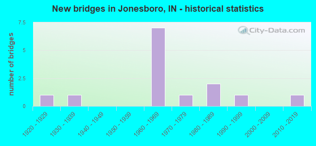
- New bridges - historical statistics
- 11920-1929
- 11930-1939
- 71960-1969
- 11970-1979
- 21980-1989
- 11990-1999
- 12010-2019

- Reconstructed bridges - Historical Statistics
- 11950-1959
- 01960-1969
- 01970-1979
- 01980-1989
- 11990-1999
- 22000-2009


- Bridge Condition - Deck
- 10.0%Very good
- 60.0%Good
- 30.0%Satisfactory

- Bridge Condition - Superstructure
- 20.0%Very good
- 50.0%Good
- 30.0%Satisfactory

- Bridge Condition - Substructure
- 80.0%Good
- 20.0%Satisfactory

- Bridge Condition - Channel
- 36.4%Good
- 27.3%Satisfactory
- 27.3%Fair
- 9.1%Poor

- Bridge Condition - Culverts
- 50.0%Good
- 50.0%Satisfactory
Find on map >> Show street view
Structure Number: 389, Location: 00.05 N SR 22 (Lat: 40.489600, Lng: -85.628069), Route carried "on" structure: State highway 15, Year Built: 1938, Year Reconstructed: 1964, Status: Open, Structure Length: 2.25m (7.38ft), Average Daily Traffic: 8,754 (year 2020), Truck Traffic: 2%, Average Future Daily Traffic: 16,538 (year 2031), Design Load: H 20, Features Intersected: BACK CREEK
Minimum Vertical Clearance: 30+ m (98+ ft), Kilometerpoint: 0.080, Lanes on structure: 5, Owner: State Highway Agency, Approaching Roadway Width: 24.4m (80.1ft), Skew: 30 degrees, Material/Design: Concrete, Design/Construction: Culvert, Number Of Spans In Main Unit: 1, Length of Maximum Span: 15.2m (49.9ft), Curb-To-Curb Width: 24.4m (80.1ft), Out-to-Out Width: 29.2m (95.8ft)
Condition: Channel: Fair, Culverts: Good, Operating Rating: 89.8 metric tons, Method Used To Determine Operating Rating: Load Factor (LF), Inventory Rating: 89.8 metric tons, Method Used To Determine Inventory Rating: Load Factor (LF), Structural Evaluation: Better than present minimum criteria, Deck Geometry: Superior to present desirable criteria, Waterway Adequacy: Equal to present desirable criteria, Approach Roadway Alignment: Equal to present desirable criteria, Designated Inspection Frequency: Every 24 months, Inspection Date: June 2021
Find on map >> Show street view
Structure Number: 39575, Location: 00.79 N SR 26 (Lat: 40.434019, Lng: -85.546711), Route carried "on" structure: County highway , Year Built: 1963, Year Reconstructed: 2011, Status: Open, Structure Length: 6.74m (22.11ft), Average Daily Traffic: 966 (year 2020), Truck Traffic: 4%, Average Future Daily Traffic: 1,574 (year 2031), Design Load: HS 20, Features Intersected: I-69 NB/SB, Facility Carried by Structure: WHEELING PIKE
Minimum Vertical Clearance: 30+ m (98+ ft), Kilometerpoint: 0.000, Lanes on structure: 2, Lanes under structure: 4, Owner: State Highway Agency, Approaching Roadway Width: 7.9m (25.9ft), Skew: 1 degrees, Material/Design: Concrete continuous, Design/Construction: Stringer/Multi-beam, Number Of Spans In Main Unit: 4, Length of Maximum Span: 20.9m (68.6ft), Curb-To-Curb Width: 7.9m (25.9ft), Out-to-Out Width: 9.0m (29.5ft)
Condition: Deck: Satisfactory, Superstructure: Satisfactory, Substructure: Satisfactory, Operating Rating: 61.8 metric tons, Method Used To Determine Operating Rating: Load Factor (LF), Inventory Rating: 37.0 metric tons, Method Used To Determine Inventory Rating: Load Factor (LF), Structural Evaluation: Equal to present minimum criteria, Deck Geometry: Somewhat better than minimum adequacy, Underclear: Meets minimum limits, Approach Roadway Alignment: Equal to present desirable criteria, Designated Inspection Frequency: Every 24 months, Inspection Date: Febuary 2021, Deck Structure Type: Concrete Cast-file-Place, Wearing Surface/Protective System: Wearing Surface: Latex Concrete
Find on map >> Show street view
Structure Number: 2700101, Location: 00.07 MI W of FAIRMOUNT A (Lat: 40.467181, Lng: -85.636069), Route carried "on" structure: County highway 28, Year Built: 1968, Status: Open, Structure Length: 2.48m (8.14ft), Average Daily Traffic: 630 (year 2021), Truck Traffic: 5%, Average Future Daily Traffic: 960 (year 2041), Design Load: HS 20, Features Intersected: BACK CREEK, Facility Carried by Structure: CR 600S
Minimum Vertical Clearance: 30+ m (98+ ft), Kilometerpoint: 0.000, Lanes on structure: 2, Owner: County Highway Agency, Approaching Roadway Width: 5.5m (18.0ft), Skew: 2 degrees, Material/Design: Concrete continuous, Design/Construction: Slab, Number Of Spans In Main Unit: 3, Length of Maximum Span: 9.7m (31.8ft), Curb or Sidewalk Widths: Left: 0.2m (0.7ft), Right: 0.2m (0.7ft), Curb-To-Curb Width: 7.3m (24.0ft), Out-to-Out Width: 8.6m (28.2ft)
Condition: Deck: Good, Superstructure: Good, Substructure: Good, Channel: Satisfactory, Operating Rating: 41.1 metric tons, Method Used To Determine Operating Rating: Load Factor (LF), Inventory Rating: 31.7 metric tons, Method Used To Determine Inventory Rating: Load Factor (LF), Structural Evaluation: Better than present minimum criteria, Deck Geometry: Meets minimum limits, Waterway Adequacy: Better than present minimum criteria, Approach Roadway Alignment: Equal to present minimum criteria, Designated Inspection Frequency: Every 24 months, Inspection Date: October 2021, Deck Structure Type: Concrete Cast-file-Place, Wearing Surface/Protective System: Wearing Surface: Bituminous
Find on map >> Show street view
Structure Number: 2700108, Location: 00.31 MI N of CR 700 S (Lat: 40.456161, Lng: -85.644689), Route carried "on" structure: County highway 33, Year Built: 1965, Year Reconstructed: 2000, Status: Open, Structure Length: 1.87m (6.14ft), Average Daily Traffic: 3,420 (year 2021), Truck Traffic: 10%, Average Future Daily Traffic: 5,230 (year 2041), Design Load: HS 20, Features Intersected: BACK CREEK, Facility Carried by Structure: CR 150E
Minimum Vertical Clearance: 30+ m (98+ ft), Kilometerpoint: 0.000, Lanes on structure: 2, Owner: County Highway Agency, Approaching Roadway Width: 6.4m (21.0ft), Skew: 2 degrees, Material/Design: Steel continuous, Design/Construction: Stringer/Multi-beam, Number Of Spans In Main Unit: 3, Length of Maximum Span: 6.7m (22.0ft), Curb-To-Curb Width: 7.3m (24.0ft), Out-to-Out Width: 8.2m (26.9ft)
Condition: Deck: Good, Superstructure: Good, Substructure: Good, Channel: Satisfactory, Operating Rating: 42.3 metric tons, Method Used To Determine Operating Rating: Field evaluation and documented engineering judgment, Inventory Rating: 32.7 metric tons, Method Used To Determine Inventory Rating: Field evaluation and documented engineering judgment, Structural Evaluation: Better than present minimum criteria, Deck Geometry: High priority of replacement, Waterway Adequacy: Equal to present minimum criteria, Approach Roadway Alignment: Equal to present desirable criteria, Designated Inspection Frequency: Every 24 months, Inspection Date: October 2021, Deck Structure Type: Concrete Cast-file-Place, Wearing Surface/Protective System: Wearing Surface: Monolithic Concrete, Deck Protection: Epoxy Coated Reinforcing
Find on map >> Show street view
Structure Number: 270011, Location: 00.55 MI S of WHEELING PK (Lat: 40.435250, Lng: -85.563500), Route carried "on" structure: County highway 51, Year Built: 1984, Status: Open, Structure Length: 1.50m (4.92ft), Average Daily Traffic: 110 (year 2021), Truck Traffic: 5%, Average Future Daily Traffic: 170 (year 2041), Design Load: HS 20, Features Intersected: BARREN CREEK, Facility Carried by Structure: CR 575E
Minimum Vertical Clearance: 30+ m (98+ ft), Kilometerpoint: 0.000, Lanes on structure: 2, Owner: County Highway Agency, Approaching Roadway Width: 4.6m (15.1ft), Skew: 1 degrees, Material/Design: Prestressed concrete, Design/Construction: Box Beam or Girders - Multiple, Number Of Spans In Main Unit: 1, Length of Maximum Span: 14.6m (47.9ft), Curb-To-Curb Width: 7.2m (23.6ft), Out-to-Out Width: 7.4m (24.3ft)
Condition: Deck: Good, Superstructure: Good, Substructure: Good, Channel: Fair, Operating Rating: 36.8 metric tons, Method Used To Determine Operating Rating: Load Factor (LF), Inventory Rating: 28.4 metric tons, Method Used To Determine Inventory Rating: Load Factor (LF), Structural Evaluation: Better than present minimum criteria, Deck Geometry: Meets minimum limits, Waterway Adequacy: Better than present minimum criteria, Approach Roadway Alignment: Equal to present desirable criteria, Designated Inspection Frequency: Every 24 months, Inspection Date: October 2021, Deck Structure Type: Concrete Cast-file-Place, Wearing Surface/Protective System: Wearing Surface: Bituminous
Find on map >> Show street view
Structure Number: 2700111, Location: 00.40 E MAIN ST (Lat: 40.476211, Lng: -85.620400), Route carried "on" structure: City street , Year Built: 1984, Status: Open, Structure Length: 9.43m (30.94ft), Average Daily Traffic: 1,470 (year 2021), Truck Traffic: 10%, Average Future Daily Traffic: 2,250 (year 2041), Design Load: HS 20, Features Intersected: MISSISSINEWA RIVER, Facility Carried by Structure: 10TH ST
Minimum Vertical Clearance: 30+ m (98+ ft), Kilometerpoint: 0.000, Lanes on structure: 2, Owner: County Highway Agency, Approaching Roadway Width: 7.0m (23.0ft), Skew: 3 degrees, Material/Design: Prestressed concrete continuous, Design/Construction: Stringer/Multi-beam, Number Of Spans In Main Unit: 5, Length of Maximum Span: 18.8m (61.7ft), Curb or Sidewalk Widths: Left: 1.5m (4.9ft), Right: 0.0m, Curb-To-Curb Width: 9.2m (30.2ft), Out-to-Out Width: 11.9m (39.0ft)
Condition: Deck: Good, Superstructure: Good, Substructure: Satisfactory, Channel: Poor, Operating Rating: 57.1 metric tons, Method Used To Determine Operating Rating: Load Factor (LF), Inventory Rating: 44.0 metric tons, Method Used To Determine Inventory Rating: Load Factor (LF), Structural Evaluation: Equal to present minimum criteria, Deck Geometry: Somewhat better than minimum adequacy, Waterway Adequacy: Equal to present desirable criteria, Approach Roadway Alignment: Equal to present minimum criteria, Designated Inspection Frequency: Every 24 months, Inspection Date: October 2021, Deck Structure Type: Concrete Cast-file-Place, Wearing Surface/Protective System: Wearing Surface: Monolithic Concrete
Find on map >> Show street view
Structure Number: 2700147, Location: 00.11 MI N of SR 22 (Lat: 40.490361, Lng: -85.626819), Route carried "on" structure: City street , Year Built: 1994, Status: Open, Structure Length: 2.51m (8.23ft), Average Daily Traffic: 2,420 (year 2021), Truck Traffic: 6%, Average Future Daily Traffic: 3,700 (year 2041), Design Load: HS 20, Features Intersected: BACK CREEK, Facility Carried by Structure: WATER ST
Minimum Vertical Clearance: 30+ m (98+ ft), Kilometerpoint: 0.000, Lanes on structure: 2, Owner: County Highway Agency, Approaching Roadway Width: 6.4m (21.0ft), Skew: 3 degrees, Material/Design: Prestressed concrete, Design/Construction: Stringer/Multi-beam, Number Of Spans In Main Unit: 1, Length of Maximum Span: 24.2m (79.4ft), Curb-To-Curb Width: 8.6m (28.2ft), Out-to-Out Width: 9.5m (31.2ft)
Condition: Deck: Good, Superstructure: Very good, Substructure: Good, Channel: Good, Operating Rating: 30.3 metric tons, Method Used To Determine Operating Rating: Load Factor (LF), Inventory Rating: 23.4 metric tons, Method Used To Determine Inventory Rating: Load Factor (LF), Structural Evaluation: Equal to present minimum criteria, Deck Geometry: Meets minimum limits, Waterway Adequacy: Better than present minimum criteria, Approach Roadway Alignment: Equal to present minimum criteria, Designated Inspection Frequency: Every 24 months, Inspection Date: October 2021, Deck Structure Type: Concrete Cast-file-Place, Wearing Surface/Protective System: Wearing Surface: Monolithic Concrete, Deck Protection: Epoxy Coated Reinforcing
Find on map >> Show street view
Structure Number: 2700153, Location: 00.05 MI W of FAIRMOUNT A (Lat: 40.477111, Lng: -85.631561), Route carried "on" structure: City street , Year Built: 1960, Status: Open, Structure Length: 1.52m (4.99ft), Average Daily Traffic: 1,050 (year 2021), Truck Traffic: 6%, Average Future Daily Traffic: 1,600 (year 2041), Design Load: HS 20, Features Intersected: BACK CREEK, Facility Carried by Structure: 9TH ST
Minimum Vertical Clearance: 30+ m (98+ ft), Kilometerpoint: 0.000, Lanes on structure: 2, Owner: County Highway Agency, Approaching Roadway Width: 7.9m (25.9ft), Material/Design: Prestressed concrete, Design/Construction: Box Beam or Girders - Multiple, Number Of Spans In Main Unit: 1, Length of Maximum Span: 14.2m (46.6ft), Curb-To-Curb Width: 8.5m (27.9ft), Out-to-Out Width: 8.6m (28.2ft)
Condition: Deck: Satisfactory, Superstructure: Satisfactory, Substructure: Good, Channel: Good, Operating Rating: 46.4 metric tons, Method Used To Determine Operating Rating: Load Factor (LF), Inventory Rating: 35.8 metric tons, Method Used To Determine Inventory Rating: Load Factor (LF), Structural Evaluation: Equal to present minimum criteria, Deck Geometry: Somewhat better than minimum adequacy, Waterway Adequacy: Better than present minimum criteria, Approach Roadway Alignment: Equal to present desirable criteria, Designated Inspection Frequency: Every 24 months, Inspection Date: October 2021, Deck Structure Type: Concrete Precast Panels, Wearing Surface/Protective System: Wearing Surface: Bituminous, Membrane: Preformed Fabric
Find on map >> Show street view
Structure Number: 2700155, Location: 00.08 MI W of SR 15 (Lat: 40.487089, Lng: -85.629281), Route carried "on" structure: City street , Year Built: 1965, Status: Open, Structure Length: 1.06m (3.48ft), Average Daily Traffic: 470 (year 2021), Truck Traffic: 5%, Average Future Daily Traffic: 720 (year 2041), Features Intersected: BACK CREEK, Facility Carried by Structure: PEARL ST
Minimum Vertical Clearance: 30+ m (98+ ft), Kilometerpoint: 0.000, Lanes on structure: 2, Owner: County Highway Agency, Approaching Roadway Width: 6.7m (22.0ft), Material/Design: Concrete, Design/Construction: Culvert, Number Of Spans In Main Unit: 3, Length of Maximum Span: 3.4m (11.2ft), Curb-To-Curb Width: 8.0m (26.2ft), Out-to-Out Width: 21.6m (70.9ft)
Condition: Channel: Fair, Culverts: Satisfactory, Operating Rating: 33.9 metric tons, Method Used To Determine Operating Rating: Field evaluation and documented engineering judgment, Inventory Rating: 26.1 metric tons, Method Used To Determine Inventory Rating: Field evaluation and documented engineering judgment, Structural Evaluation: Equal to present minimum criteria, Deck Geometry: Somewhat better than minimum adequacy, Waterway Adequacy: Better than present minimum criteria, Approach Roadway Alignment: Equal to present minimum criteria, Designated Inspection Frequency: Every 24 months, Inspection Date: October 2021, Wearing Surface/Protective System: Wearing Surface: Bituminous
Find on map >> Show street view
Structure Number: 2700156, Location: 00.17 MI W of SR 15 (Lat: 40.480481, Lng: -85.631089), Route carried "on" structure: City street , Year Built: 1973, Status: Open, Structure Length: 3.54m (11.61ft), Average Daily Traffic: 3,370 (year 2021), Truck Traffic: 10%, Average Future Daily Traffic: 5,150 (year 2041), Design Load: HS 20, Features Intersected: BACK CREEK, Facility Carried by Structure: 6TH ST
Minimum Vertical Clearance: 30+ m (98+ ft), Kilometerpoint: 0.000, Lanes on structure: 2, Owner: County Highway Agency, Approaching Roadway Width: 7.3m (24.0ft), Skew: 2 degrees, Material/Design: Prestressed concrete, Design/Construction: Stringer/Multi-beam, Number Of Spans In Main Unit: 3, Length of Maximum Span: 12.1m (39.7ft), Curb or Sidewalk Widths: Left: 1.2m (3.9ft), Right: 1.2m (3.9ft), Curb-To-Curb Width: 9.8m (32.2ft), Out-to-Out Width: 12.8m (42.0ft)
Condition: Deck: Good, Superstructure: Good, Substructure: Good, Channel: Good, Operating Rating: 45.5 metric tons, Method Used To Determine Operating Rating: Load Factor (LF), Inventory Rating: 35.1 metric tons, Method Used To Determine Inventory Rating: Load Factor (LF), Structural Evaluation: Better than present minimum criteria, Deck Geometry: Meets minimum limits, Waterway Adequacy: Better than present minimum criteria, Approach Roadway Alignment: Equal to present minimum criteria, Designated Inspection Frequency: Every 24 months, Inspection Date: October 2021, Deck Structure Type: Concrete Cast-file-Place, Wearing Surface/Protective System: Wearing Surface: Monolithic Concrete
Find on map >> Show street view
Structure Number: 270079, Location: 00.21 MI. W. of BOOTS ST (Lat: 40.550061, Lng: -85.665111), Route carried "on" structure: City street , Year Built: 1921, Year Reconstructed: 2003, Status: Open, Structure Length: 0.64m (2.10ft), Average Daily Traffic: 1,000 (year 2021), Truck Traffic: 8%, Average Future Daily Traffic: 1,530 (year 2041), Design Load: HS 20, Features Intersected: BOOTS CREEK, Facility Carried by Structure: 12TH ST
Minimum Vertical Clearance: 30+ m (98+ ft), Kilometerpoint: 0.000, Lanes on structure: 2, Owner: County Highway Agency, Approaching Roadway Width: 8.4m (27.6ft), Material/Design: Prestressed concrete, Design/Construction: Box Beam or Girders - Multiple, Number Of Spans In Main Unit: 1, Length of Maximum Span: 6.1m (20.0ft), Curb-To-Curb Width: 8.4m (27.6ft), Out-to-Out Width: 8.6m (28.2ft)
Condition: Deck: Satisfactory, Superstructure: Satisfactory, Substructure: Good, Channel: Satisfactory, Operating Rating: 59.9 metric tons, Method Used To Determine Operating Rating: Load Factor (LF), Inventory Rating: 46.2 metric tons, Method Used To Determine Inventory Rating: Load Factor (LF), Structural Evaluation: Equal to present minimum criteria, Deck Geometry: Somewhat better than minimum adequacy, Waterway Adequacy: Equal to present minimum criteria, Approach Roadway Alignment: Equal to present desirable criteria, Designated Inspection Frequency: Every 24 months, Inspection Date: October 2021, Deck Structure Type: Concrete Precast Panels
Find on map >> Show street view
Structure Number: 2700799, Location: 00.08 MI W of MAIN STREET (Lat: 40.484919, Lng: -85.629300), Route carried "on" structure: City street , Year Built: 2010, Status: Open, Structure Length: 1.66m (5.45ft), Average Daily Traffic: 840 (year 2021), Truck Traffic: 6%, Average Future Daily Traffic: 1,280 (year 2041), Design Load: HS 25 or greater, Features Intersected: BACK CREEK, Facility Carried by Structure: 2ND ST
Minimum Vertical Clearance: 30+ m (98+ ft), Kilometerpoint: 0.000, Lanes on structure: 2, Owner: County Highway Agency, Approaching Roadway Width: 6.7m (22.0ft), Material/Design: Concrete, Design/Construction: Slab, Number Of Spans In Main Unit: 1, Length of Maximum Span: 15.3m (50.2ft), Curb-To-Curb Width: 8.5m (27.9ft), Out-to-Out Width: 9.4m (30.8ft)
Condition: Deck: Very good, Superstructure: Very good, Substructure: Good, Channel: Good, Operating Rating: 32.7 metric tons, Method Used To Determine Operating Rating: Field evaluation and documented engineering judgment, Inventory Rating: 32.7 metric tons, Method Used To Determine Inventory Rating: Field evaluation and documented engineering judgment, Structural Evaluation: Better than present minimum criteria, Deck Geometry: Somewhat better than minimum adequacy, Waterway Adequacy: Better than present minimum criteria, Approach Roadway Alignment: Equal to present minimum criteria, Designated Inspection Frequency: Every 24 months, Inspection Date: October 2021, Deck Structure Type: Concrete Cast-file-Place, Wearing Surface/Protective System: Wearing Surface: Monolithic Concrete, Deck Protection: Epoxy Coated Reinforcing
Find on map >> Show street view
Structure Number: 39575, Location: 00.79 N SR 26 (Lat: 40.434019, Lng: -85.546731), Route carried "under" structure: Interstate 69, Year Built: 1963, Structure Length: 0. m, Average Daily Traffic: 12,895 (year 2019), Truck Traffic: 37%, Features Intersected: I-69 SB, Facility Carried by Structure: WHEELING PIKE
Minimum Vertical Clearance: 5.66m (18.57ft), Kilometerpoint: 411.558, Lanes on structure: 2, Lanes under structure: 2, Material/Design: Concrete continuous, Design/Construction: Stringer/Multi-beam, Length of Maximum Span: 20.9m (68.6ft)
Find on map >> Show street view
Structure Number: 39575, Location: 00.79 N SR 26 (Lat: 40.434019, Lng: -85.546731), Route carried "under" structure: Interstate 69, Year Built: 1963, Structure Length: 0. m, Average Daily Traffic: 13,160 (year 2019), Truck Traffic: 37%, Features Intersected: I-69 SB, Facility Carried by Structure: WHEELING PIKE
Minimum Vertical Clearance: 5.66m (18.57ft), Kilometerpoint: 411.558, Lanes on structure: 2, Lanes under structure: 2, Material/Design: Concrete continuous, Design/Construction: Stringer/Multi-beam, Length of Maximum Span: 20.9m (68.6ft)