Bridge Statistics for Kachina Village, Arizona (AZ)
Condition, Traffic, Stress, Structural Evaluation, Project Costs
- National Bridge Inventory (NBI) Statistics
- 10Number of bridges
- 52ft / 16.1mTotal length
- $1,000Total costs
- 30,224Total average daily traffic
- 3,969Total average daily truck traffic
- National Bridge Inventory (NBI) Registered Bridges for Kachina Village
- No street view available for this location
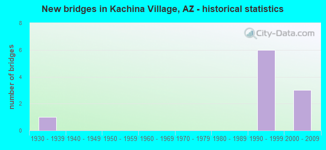
- New bridges - historical statistics
- 11930-1939
- 61990-1999
- 32000-2009


- Bridge Condition - Culverts
- 12.5%Very good
- 62.5%Good
- 25.0%Satisfactory
Find on map >> Show street view
Structure Number: 2091, Location: 6.1 mi S Jct I-40 (Lat: 35.089800, Lng: -111.686200), Route carried "on" structure: Interstate 17, Year Built: 1991, Status: Open, Structure Length: 5.30m (17.39ft), Average Daily Traffic: 11,450 (year 2017), Truck Traffic: 24%, Average Future Daily Traffic: 11,460 (year 2038), Design Load: HS 20, Features Intersected: Kachina Blvd
Minimum Vertical Clearance: 30+ m (98+ ft), Kilometerpoint: 537.312, Lanes on structure: 2, Lanes under structure: 3, Owner: State Highway Agency, Approaching Roadway Width: 11.6m (38.1ft), Material/Design: Prestressed concrete continuous, Design/Construction: Stringer/Multi-beam, Number Of Spans In Main Unit: 3, Length of Maximum Span: 27.4m (89.9ft), Curb-To-Curb Width: 12.8m (42.0ft), Out-to-Out Width: 13.8m (45.3ft)
Condition: Deck: Satisfactory, Superstructure: Good, Substructure: Good, Operating Rating: 89.8 metric tons, Method Used To Determine Operating Rating: Load Factor (LF), Inventory Rating: 32.7 metric tons, Method Used To Determine Inventory Rating: Load Factor (LF), Structural Evaluation: Better than present minimum criteria, Deck Geometry: Equal to present desirable criteria, Underclear: Better than present minimum criteria, Approach Roadway Alignment: Equal to present desirable criteria, Designated Inspection Frequency: Every 24 months, Inspection Date: July 2020, Deck Structure Type: Concrete Cast-file-Place, Wearing Surface/Protective System: Wearing Surface: Bituminous, Deck Protection: Epoxy Coated Reinforcing
Find on map >> Show street view
Structure Number: 6967, Location: 9.4 mi S of Jct I 40 (Lat: 35.064600, Lng: -111.733100), Route carried "on" structure: Alternate State highway 89, Year Built: 1936, Year Reconstructed: 2017, Status: Open, Structure Length: 0.76m (2.49ft), Average Daily Traffic: 3,858 (year 2016), Truck Traffic: 9%, Average Future Daily Traffic: 3,868 (year 2036), Design Load: HS 20, Features Intersected: Fry Canyon
Minimum Vertical Clearance: 30+ m (98+ ft), Kilometerpoint: 631.470, Lanes on structure: 2, Owner: State Highway Agency, Approaching Roadway Width: 7.0m (23.0ft), Material/Design: Concrete, Design/Construction: Culvert, Number Of Spans In Main Unit: 1, Length of Maximum Span: 6.7m (22.0ft)
Condition: Channel: Good, Culverts: Satisfactory, Operating Rating: 89.8 metric tons, Method Used To Determine Operating Rating: Load Factor (LF), Inventory Rating: 89.8 metric tons, Method Used To Determine Inventory Rating: Load Factor (LF), Structural Evaluation: Equal to present minimum criteria, Waterway Adequacy: Better than present minimum criteria, Approach Roadway Alignment: Equal to present minimum criteria, Designated Inspection Frequency: Every 48 months, Inspection Date: August 2021
Find on map >> Show street view
Structure Number: 6998, Location: 4.7 mi S Jct I-40 (Lat: 35.120200, Lng: -111.707700), Route carried "on" structure: Alternate State highway 89, Year Built: 1994, Status: Open, Structure Length: 0.98m (3.22ft), Average Daily Traffic: 3,858 (year 2016), Truck Traffic: 9%, Average Future Daily Traffic: 3,868 (year 2036), Design Load: HS 20, Features Intersected: Landon Spring
Minimum Vertical Clearance: 30+ m (98+ ft), Kilometerpoint: 638.765, Lanes on structure: 2, Owner: State Highway Agency, Approaching Roadway Width: 7.3m (24.0ft), Material/Design: Concrete continuous, Design/Construction: Culvert, Number Of Spans In Main Unit: 3, Length of Maximum Span: 3.0m (9.8ft)
Condition: Channel: Good, Culverts: Good, Operating Rating: 89.8 metric tons, Method Used To Determine Operating Rating: Load Factor (LF), Inventory Rating: 89.8 metric tons, Method Used To Determine Inventory Rating: Load Factor (LF), Structural Evaluation: Better than present minimum criteria, Waterway Adequacy: Better than present minimum criteria, Approach Roadway Alignment: Equal to present minimum criteria, Length Of Structure Improvement: 1.25m (4.10ft), Designated Inspection Frequency: Every 48 months, Inspection Date: August 2021, Total Project Cost: $1,000 ( Estimate for 2021)
Find on map >> Show street view
Structure Number: 6999, Location: 7.0 mi S of Jct I 40 (Lat: 35.095900, Lng: -111.732900), Route carried "on" structure: Alternate State highway 89, Year Built: 1994, Status: Open, Structure Length: 1.07m (3.51ft), Average Daily Traffic: 3,858 (year 2016), Truck Traffic: 9%, Average Future Daily Traffic: 3,868 (year 2036), Design Load: HS 20, Features Intersected: Woody Wash
Minimum Vertical Clearance: 30+ m (98+ ft), Kilometerpoint: 635.047, Lanes on structure: 2, Owner: State Highway Agency, Approaching Roadway Width: 7.3m (24.0ft), Skew: 4 degrees, Material/Design: Concrete continuous, Design/Construction: Culvert, Number Of Spans In Main Unit: 2, Length of Maximum Span: 3.7m (12.1ft)
Condition: Channel: Good, Culverts: Satisfactory, Operating Rating: 65.3 metric tons, Method Used To Determine Operating Rating: Load Factor (LF), Inventory Rating: 39.0 metric tons, Method Used To Determine Inventory Rating: Load Factor (LF), Structural Evaluation: Equal to present minimum criteria, Waterway Adequacy: Better than present minimum criteria, Approach Roadway Alignment: Better than present minimum criteria, Designated Inspection Frequency: Every 48 months, Inspection Date: August 2021
Find on map >> Show street view
Structure Number: 1059, Location: 0.5 mi N Jct Kachina Blvd (Lat: 35.096200, Lng: -111.684700), Route carried "on" structure: County highway , Year Built: 1996, Status: Open, Structure Length: 1.19m (3.90ft), Average Daily Traffic: 650 (year 2018), Average Future Daily Traffic: 660 (year 2038), Design Load: HS 20, Features Intersected: Pumphouse Wash, Facility Carried by Structure: Tovar Trail
Minimum Vertical Clearance: 30+ m (98+ ft), Kilometerpoint: 0.000, Lanes on structure: 2, Owner: County Highway Agency, Approaching Roadway Width: 8.5m (27.9ft), Skew: 3 degrees, Material/Design: Concrete continuous, Design/Construction: Culvert, Number Of Spans In Main Unit: 3, Length of Maximum Span: 3.0m (9.8ft)
Condition: Channel: Good, Culverts: Good, Operating Rating: 52.6 metric tons, Method Used To Determine Operating Rating: Load Factor (LF), Inventory Rating: 31.8 metric tons, Method Used To Determine Inventory Rating: Load Factor (LF), Structural Evaluation: Better than present minimum criteria, Waterway Adequacy: Equal to present desirable criteria, Approach Roadway Alignment: Equal to present desirable criteria, Designated Inspection Frequency: Every 48 months, Inspection Date: July 2018, Deck Structure Type: Concrete Cast-file-Place, Wearing Surface/Protective System: Wearing Surface: Bituminous
Find on map >> Show street view
Structure Number: 10591, Location: 0.3 mi N Jct Kachina Blvd (Lat: 35.093000, Lng: -111.690500), Route carried "on" structure: County highway , Year Built: 1992, Status: Open, Structure Length: 2.41m (7.91ft), Average Daily Traffic: 2,670 (year 2018), Average Future Daily Traffic: 2,680 (year 2038), Design Load: HS 20, Features Intersected: Pumphouse Wash, Facility Carried by Structure: Kachina Trail
Minimum Vertical Clearance: 0.00m, Kilometerpoint: 0.000, Lanes on structure: 2, Owner: County Highway Agency, Approaching Roadway Width: 9.8m (32.2ft), Material/Design: Concrete continuous, Design/Construction: Culvert, Number Of Spans In Main Unit: 6, Length of Maximum Span: 3.7m (12.1ft), Curb or Sidewalk Widths: Left: 1.5m (4.9ft), Right: 1.5m (4.9ft)
Condition: Channel: Good, Culverts: Good, Operating Rating: 89.8 metric tons, Method Used To Determine Operating Rating: Load Factor (LF), Inventory Rating: 89.8 metric tons, Method Used To Determine Inventory Rating: Load Factor (LF), Structural Evaluation: Better than present minimum criteria, Waterway Adequacy: Equal to present desirable criteria, Approach Roadway Alignment: Equal to present minimum criteria, Designated Inspection Frequency: Every 48 months, Inspection Date: July 2018
Find on map >> Show street view
Structure Number: 10592, Location: 90 ft S Jct Ancient Trail (Lat: 35.088500, Lng: -111.697600), Route carried "on" structure: County highway , Year Built: 2004, Status: Open, Structure Length: 1.58m (5.18ft), Average Daily Traffic: 380 (year 2018), Average Future Daily Traffic: 390 (year 2038), Design Load: HS 20, Features Intersected: Pumphouse Wash, Facility Carried by Structure: Tonalea Trail
Minimum Vertical Clearance: 30+ m (98+ ft), Kilometerpoint: 0.000, Lanes on structure: 2, Owner: County Highway Agency, Approaching Roadway Width: 9.8m (32.2ft), Material/Design: Concrete continuous, Design/Construction: Culvert, Number Of Spans In Main Unit: 4, Length of Maximum Span: 3.7m (12.1ft)
Condition: Channel: Good, Culverts: Very good, Operating Rating: 64.4 metric tons, Method Used To Determine Operating Rating: Load Factor (LF), Inventory Rating: 38.1 metric tons, Method Used To Determine Inventory Rating: Load Factor (LF), Structural Evaluation: Equal to present desirable criteria, Waterway Adequacy: Equal to present desirable criteria, Approach Roadway Alignment: Equal to present minimum criteria, Designated Inspection Frequency: Every 48 months, Inspection Date: July 2018
Find on map >> Show street view
Structure Number: 10593, Location: 0.7 mi W Jct Kachina Tr. (Lat: 35.090600, Lng: -111.698400), Route carried "on" structure: County highway , Year Built: 2004, Status: Open, Structure Length: 1.58m (5.18ft), Average Daily Traffic: 850 (year 2018), Average Future Daily Traffic: 860 (year 2038), Design Load: HS 20, Features Intersected: Pumphouse Wash, Facility Carried by Structure: Pinon Trail
Minimum Vertical Clearance: 30+ m (98+ ft), Kilometerpoint: 0.000, Lanes on structure: 2, Owner: County Highway Agency, Approaching Roadway Width: 9.8m (32.2ft), Material/Design: Concrete continuous, Design/Construction: Culvert, Number Of Spans In Main Unit: 4, Length of Maximum Span: 3.7m (12.1ft), Curb-To-Curb Width: 18.5m (60.7ft), Out-to-Out Width: 18.5m (60.7ft)
Condition: Channel: Good, Culverts: Good, Operating Rating: 59.0 metric tons, Method Used To Determine Operating Rating: Load Factor (LF), Inventory Rating: 36.3 metric tons, Method Used To Determine Inventory Rating: Load Factor (LF), Structural Evaluation: Better than present minimum criteria, Deck Geometry: Superior to present desirable criteria, Waterway Adequacy: Equal to present desirable criteria, Approach Roadway Alignment: Equal to present minimum criteria, Designated Inspection Frequency: Every 48 months, Inspection Date: July 2018, Deck Structure Type: Concrete Cast-file-Place, Wearing Surface/Protective System: Wearing Surface: Bituminous
Find on map >> Show street view
Structure Number: 10594, Location: 0.9 mi W Jct Kachina Tr (Lat: 35.091800, Lng: -111.701400), Route carried "on" structure: County highway , Year Built: 2004, Status: Open, Structure Length: 1.25m (4.10ft), Average Daily Traffic: 850 (year 2018), Average Future Daily Traffic: 860 (year 2038), Design Load: HS 20, Features Intersected: Pumphouse Wash, Facility Carried by Structure: Pinon Trail
Minimum Vertical Clearance: 30+ m (98+ ft), Kilometerpoint: 0.000, Lanes on structure: 2, Owner: County Highway Agency, Approaching Roadway Width: 9.8m (32.2ft), Skew: 2 degrees, Material/Design: Concrete continuous, Design/Construction: Culvert, Number Of Spans In Main Unit: 3, Length of Maximum Span: 3.7m (12.1ft), Curb or Sidewalk Widths: Left: 0.0m, Right: 1.8m (5.9ft)
Condition: Channel: Good, Culverts: Good, Operating Rating: 60.8 metric tons, Method Used To Determine Operating Rating: Load Factor (LF), Inventory Rating: 36.3 metric tons, Method Used To Determine Inventory Rating: Load Factor (LF), Structural Evaluation: Better than present minimum criteria, Waterway Adequacy: Equal to present desirable criteria, Approach Roadway Alignment: Equal to present minimum criteria, Designated Inspection Frequency: Every 48 months, Inspection Date: July 2018, Deck Structure Type: Concrete Cast-file-Place, Wearing Surface/Protective System: Wearing Surface: Bituminous
Find on map >> Show street view
Structure Number: 2091, Location: 6.1 mi S Jct I-40 (Lat: 35.089800, Lng: -111.686200), Route carried "under" structure: County highway , Year Built: 1991, Structure Length: 0. m, Average Daily Traffic: 1,800 (year 2018), Truck Traffic: 10%, Features Intersected: Kachina Blvd, Facility Carried by Structure: I 17 SB
Minimum Vertical Clearance: 5.08m (16.67ft), Kilometerpoint: 0.000, Lanes on structure: 2, Lanes under structure: 2, Material/Design: Prestressed concrete continuous, Design/Construction: Stringer/Multi-beam, Length of Maximum Span: 27.4m (89.9ft)