Bridge Statistics for Katonah, New York (NY)
Condition, Traffic, Stress, Structural Evaluation, Project Costs
- National Bridge Inventory (NBI) Statistics
- 26Number of bridges
- 335ft / 102mTotal length
- $126,320,000Total costs
- 525,179Total average daily traffic
- 31,365Total average daily truck traffic
- National Bridge Inventory (NBI) Registered Bridges for Katonah
- No street view available for this location
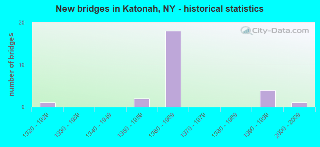
- New bridges - historical statistics
- 11920-1929
- 21950-1959
- 181960-1969
- 41990-1999
- 12000-2009


- Bridge Condition - Deck
- 6.7%Very good
- 53.3%Good
- 33.3%Satisfactory
- 6.7%Fair

- Bridge Condition - Superstructure
- 6.7%Very good
- 6.7%Good
- 66.7%Satisfactory
- 20.0%Fair

- Bridge Condition - Substructure
- 20.0%Good
- 53.3%Satisfactory
- 20.0%Fair
- 6.7%Poor

- Bridge Condition - Channel
- 33.3%Very good
- 33.3%Good
- 8.3%Satisfactory
- 25.0%Fair
Find on map >> Show street view
Structure Number: 102343, Location: .1 MI S JCT SH 22 & SH 35 (Lat: 41.265003, Lng: -73.676547), Route carried "on" structure: State highway 22, Year Built: 2002, Status: Open, Structure Length: 2.50m (8.20ft), Average Daily Traffic: 5,630 (year 2015), Truck Traffic: 4%, Average Future Daily Traffic: 5,656 (year 2040), Design Load: HS 25 or greater, Features Intersected: CROSS RIVER
Minimum Vertical Clearance: 30+ m (98+ ft), Kilometerpoint: 50.909, Lanes on structure: 3, Base Highway Network: Yes, Owner: State Highway Agency, Approaching Roadway Width: 14.3m (46.9ft), Material/Design: Prestressed concrete, Design/Construction: Box Beam or Girders - Single/Spread, Number Of Spans In Main Unit: 1, Length of Maximum Span: 24.0m (78.7ft), Curb or Sidewalk Widths: Left: 0.0m, Right: 1.5m (4.9ft), Curb-To-Curb Width: 15.0m (49.2ft), Out-to-Out Width: 17.3m (56.8ft)
Condition: Deck: Satisfactory, Superstructure: Very good, Substructure: Good, Channel: Good, Operating Rating: 42.8 metric tons, Method Used To Determine Operating Rating: Load and Resistance Factor Rating (LRFR) rating reported by rating factor(RF) method using HL-93 loadings, Inventory Rating: 33.0 metric tons, Method Used To Determine Inventory Rating: Load and Resistance Factor Rating (LRFR) rating reported by rating factor(RF) method using HL-93 loadings, Structural Evaluation: Better than present minimum criteria, Deck Geometry: Equal to present minimum criteria, Waterway Adequacy: Superior to present desirable criteria, Approach Roadway Alignment: Equal to present desirable criteria, Length Of Structure Improvement: 2.49m (8.17ft), Designated Inspection Frequency: Every 24 months, Inspection Date: July 2020, Bridge Improvement Cost: $1,387,000, Roadway Improvement Cost: $812,000, Total Project Cost: $2,200,000 ( Estimate for 2021), Deck Structure Type: Concrete Cast-file-Place, Wearing Surface/Protective System: Wearing Surface: Integral Concrete, Deck Protection: Galvanized Reinforcing
Find on map >> Show street view
Structure Number: 1053121, Location: 3.6 MI N JCT I684 & SH172 (Lat: 41.245081, Lng: -73.673497), Route carried "on" structure: Interstate 684, Year Built: 1968, Status: Open, Structure Length: 12.86m (42.19ft), Average Daily Traffic: 28,096 (year 2000), Truck Traffic: 15%, Design Load: HS 20+Mod, Features Intersected: BEAVER DAM ROAD, BROAD B
Minimum Vertical Clearance: 30+ m (98+ ft), Kilometerpoint: 26.146, Lanes on structure: 3, Lanes under structure: 2, Base Highway Network: Yes, Owner: State Highway Agency, Approaching Roadway Width: 14.9m (48.9ft), Skew: 4 degrees, Material/Design: Steel, Design/Construction: Stringer/Multi-beam, Number Of Spans In Main Unit: 4, Length of Maximum Span: 34.1m (111.9ft), Curb-To-Curb Width: 13.4m (44.0ft), Out-to-Out Width: 14.3m (46.9ft)
Condition: Deck: Good, Superstructure: Satisfactory, Substructure: Satisfactory, Channel: Good, Operating Rating: 88.0 metric tons, Method Used To Determine Operating Rating: Load Factor (LF), Inventory Rating: 52.6 metric tons, Method Used To Determine Inventory Rating: Load Factor (LF), Structural Evaluation: Equal to present minimum criteria, Deck Geometry: Meets minimum limits, Underclear: Meets minimum limits, Waterway Adequacy: Equal to present minimum criteria, Approach Roadway Alignment: Equal to present desirable criteria, Length Of Structure Improvement: 12.86m (42.19ft), Designated Inspection Frequency: Every 24 months, Inspection Date: May 2021, Bridge Improvement Cost: $7,553,000, Roadway Improvement Cost: $4,423,000, Total Project Cost: $11,977,000 ( Estimate for 2021), Deck Structure Type: Concrete Cast-file-Place, Wearing Surface/Protective System: Wearing Surface: Monolithic Concrete
Find on map >> Show street view
Structure Number: 1053122, Location: 3.6 MI N JCT I684 & SH172 (Lat: 41.245181, Lng: -73.673178), Route carried "on" structure: Interstate 684, Year Built: 1968, Status: Open, Structure Length: 12.56m (41.21ft), Average Daily Traffic: 26,716 (year 2020), Truck Traffic: 11%, Average Future Daily Traffic: 45,241 (year 2040), Design Load: HS 20+Mod, Features Intersected: BEAVER DAM ROAD, BROAD B
Minimum Vertical Clearance: 30+ m (98+ ft), Kilometerpoint: 26.178, Lanes on structure: 3, Lanes under structure: 2, Base Highway Network: Yes, Owner: State Highway Agency, Approaching Roadway Width: 14.9m (48.9ft), Skew: 4 degrees, Material/Design: Steel, Design/Construction: Stringer/Multi-beam, Number Of Spans In Main Unit: 4, Length of Maximum Span: 33.5m (109.9ft), Curb-To-Curb Width: 12.8m (42.0ft), Out-to-Out Width: 14.3m (46.9ft)
Condition: Deck: Satisfactory, Superstructure: Satisfactory, Substructure: Satisfactory, Channel: Very good, Operating Rating: 87.1 metric tons, Method Used To Determine Operating Rating: Load Factor (LF), Inventory Rating: 51.7 metric tons, Method Used To Determine Inventory Rating: Load Factor (LF), Structural Evaluation: Equal to present minimum criteria, Deck Geometry: Meets minimum limits, Underclear: Meets minimum limits, Waterway Adequacy: Equal to present minimum criteria, Approach Roadway Alignment: Equal to present desirable criteria, Length Of Structure Improvement: 12.55m (41.17ft), Designated Inspection Frequency: Every 24 months, Inspection Date: May 2021, Bridge Improvement Cost: $7,446,000, Roadway Improvement Cost: $4,360,000, Total Project Cost: $11,806,000 ( Estimate for 2021), Deck Structure Type: Concrete Cast-file-Place, Wearing Surface/Protective System: Wearing Surface: Monolithic Concrete
Find on map >> Show street view
Structure Number: 1053131, Location: 4.1 MI N JCT RTS I684+172 (Lat: 41.251817, Lng: -73.675247), Route carried "on" structure: Interstate 684, Year Built: 1968, Status: Open, Structure Length: 8.29m (27.20ft), Average Daily Traffic: 28,096 (year 2000), Truck Traffic: 15%, Design Load: HS 20+Mod, Features Intersected: STONE HILL RIVER
Minimum Vertical Clearance: 30+ m (98+ ft), Kilometerpoint: 26.919, Lanes on structure: 3, Base Highway Network: Yes, Owner: State Highway Agency, Approaching Roadway Width: 15.2m (49.9ft), Skew: 2 degrees, Material/Design: Steel, Design/Construction: Stringer/Multi-beam, Number Of Spans In Main Unit: 2, Length of Maximum Span: 40.5m (132.9ft), Curb-To-Curb Width: 12.8m (42.0ft), Out-to-Out Width: 14.3m (46.9ft)
Condition: Deck: Good, Superstructure: Satisfactory, Substructure: Satisfactory, Channel: Very good, Inventory Rating: 59.9 metric tons, Method Used To Determine Inventory Rating: Load Factor (LF), Structural Evaluation: Equal to present minimum criteria, Deck Geometry: Meets minimum limits, Waterway Adequacy: Superior to present desirable criteria, Approach Roadway Alignment: Equal to present desirable criteria, Length Of Structure Improvement: 8.29m (27.20ft), Designated Inspection Frequency: Every 24 months, Inspection Date: September 2020, Bridge Improvement Cost: $4,667,000, Roadway Improvement Cost: $2,733,000, Total Project Cost: $7,400,000 ( Estimate for 2021), Deck Structure Type: Concrete Cast-file-Place, Wearing Surface/Protective System: Wearing Surface: Monolithic Concrete
Find on map >> Show street view
Structure Number: 1053132, Location: 4.1 MI N JCT RTS I684+172 (Lat: 41.251858, Lng: -73.674914), Route carried "on" structure: Interstate 684, Year Built: 1968, Status: Open, Structure Length: 8.32m (27.30ft), Average Daily Traffic: 26,716 (year 2020), Truck Traffic: 11%, Average Future Daily Traffic: 45,241 (year 2040), Design Load: HS 20+Mod, Features Intersected: WHITE HILL RIVER
Minimum Vertical Clearance: 30+ m (98+ ft), Kilometerpoint: 26.951, Lanes on structure: 3, Base Highway Network: Yes, Owner: State Highway Agency, Approaching Roadway Width: 15.2m (49.9ft), Skew: 2 degrees, Material/Design: Steel, Design/Construction: Stringer/Multi-beam, Number Of Spans In Main Unit: 2, Length of Maximum Span: 40.8m (133.9ft), Curb or Sidewalk Widths: Left: 0.5m (1.6ft), Right: 0.5m (1.6ft), Curb-To-Curb Width: 12.8m (42.0ft), Out-to-Out Width: 14.3m (46.9ft)
Condition: Deck: Good, Superstructure: Satisfactory, Substructure: Satisfactory, Channel: Good, Operating Rating: 43.7 metric tons, Method Used To Determine Operating Rating: Load and Resistance Factor Rating (LRFR) rating reported by rating factor(RF) method using HL-93 loadings, Inventory Rating: 33.7 metric tons, Method Used To Determine Inventory Rating: Load and Resistance Factor Rating (LRFR) rating reported by rating factor(RF) method using HL-93 loadings, Structural Evaluation: Equal to present minimum criteria, Deck Geometry: Meets minimum limits, Waterway Adequacy: Equal to present minimum criteria, Approach Roadway Alignment: Equal to present desirable criteria, Length Of Structure Improvement: 8.32m (27.30ft), Designated Inspection Frequency: Every 24 months, Inspection Date: September 2020, Bridge Improvement Cost: $4,718,000, Roadway Improvement Cost: $2,763,000, Total Project Cost: $7,481,000 ( Estimate for 2021), Deck Structure Type: Concrete Cast-file-Place, Wearing Surface/Protective System: Wearing Surface: Monolithic Concrete
Find on map >> Show street view
Structure Number: 1053141, Location: JCT I684 & SMRP (Lat: 41.252956, Lng: -73.676194), Route carried "on" structure: Interstate 684, Year Built: 1966, Status: Open, Structure Length: 7.92m (25.98ft), Average Daily Traffic: 28,096 (year 2015), Truck Traffic: 15%, Design Load: H 20, Features Intersected: RTE 987D
Minimum Vertical Clearance: 30+ m (98+ ft), Kilometerpoint: 27.144, Lanes on structure: 3, Lanes under structure: 2, Base Highway Network: Yes, Owner: State Highway Agency, Approaching Roadway Width: 14.3m (46.9ft), Skew: 6 degrees, Material/Design: Steel, Design/Construction: Stringer/Multi-beam, Number Of Spans In Main Unit: 3, Length of Maximum Span: 34.1m (111.9ft), Curb-To-Curb Width: 13.3m (43.6ft), Out-to-Out Width: 14.3m (46.9ft)
Condition: Deck: Good, Superstructure: Fair, Substructure: Satisfactory, Operating Rating: 91.6 metric tons, Method Used To Determine Operating Rating: Load Factor (LF), Inventory Rating: 54.4 metric tons, Method Used To Determine Inventory Rating: Load Factor (LF), Structural Evaluation: Somewhat better than minimum adequacy, Deck Geometry: Meets minimum limits, Underclear: Meets minimum limits, Approach Roadway Alignment: Equal to present desirable criteria, Length Of Structure Improvement: 7.92m (25.98ft), Designated Inspection Frequency: Every 24 months, Inspection Date: November 2020, Bridge Improvement Cost: $5,085,000, Roadway Improvement Cost: $2,978,000, Total Project Cost: $8,063,000 ( Estimate for 2021), Deck Structure Type: Concrete Cast-file-Place, Wearing Surface/Protective System: Wearing Surface: Monolithic Concrete
Find on map >> Show street view
Structure Number: 1053142, Location: JCT I684 & SMRP (Lat: 41.253411, Lng: -73.676250), Route carried "on" structure: Interstate 684, Year Built: 1966, Status: Open, Structure Length: 7.71m (25.30ft), Average Daily Traffic: 26,716 (year 2020), Truck Traffic: 11%, Average Future Daily Traffic: 45,241 (year 2040), Design Load: H 20, Features Intersected: RTE 987D
Minimum Vertical Clearance: 30+ m (98+ ft), Kilometerpoint: 27.176, Lanes on structure: 3, Lanes under structure: 2, Base Highway Network: Yes, Owner: State Highway Agency, Approaching Roadway Width: 12.8m (42.0ft), Skew: 6 degrees, Material/Design: Steel, Design/Construction: Stringer/Multi-beam, Number Of Spans In Main Unit: 3, Length of Maximum Span: 38.1m (125.0ft), Curb or Sidewalk Widths: Left: 0.3m (1.0ft), Right: 0.3m (1.0ft), Curb-To-Curb Width: 12.8m (42.0ft), Out-to-Out Width: 14.3m (46.9ft)
Condition: Deck: Good, Superstructure: Fair, Substructure: Satisfactory, Operating Rating: 78.0 metric tons, Method Used To Determine Operating Rating: Load Factor (LF), Inventory Rating: 46.3 metric tons, Method Used To Determine Inventory Rating: Load Factor (LF), Structural Evaluation: Somewhat better than minimum adequacy, Deck Geometry: Meets minimum limits, Underclear: Meets minimum limits, Approach Roadway Alignment: Equal to present desirable criteria, Length Of Structure Improvement: 7.71m (25.30ft), Designated Inspection Frequency: Every 24 months, Inspection Date: November 2020, Bridge Improvement Cost: $4,904,000, Roadway Improvement Cost: $2,872,000, Total Project Cost: $7,775,000 ( Estimate for 2021), Deck Structure Type: Concrete Cast-file-Place, Wearing Surface/Protective System: Wearing Surface: Monolithic Concrete
Find on map >> Show street view
Structure Number: 105315, Location: 0.6MI N JCT RTS I684+SMRP (Lat: 41.260225, Lng: -73.680264), Route carried "on" structure: ServiceOther road , Year Built: 1968, Status: Open, Structure Length: 15.85m (52.00ft), Average Daily Traffic: 4,487 (year 2015), Truck Traffic: 4%, Average Future Daily Traffic: 5,450 (year 2040), Design Load: HS 20, Features Intersected: 684I684I87011175, ACCESS, Facility Carried by Structure: JAY STREET
Minimum Vertical Clearance: 30+ m (98+ ft), Kilometerpoint: 0.241, Lanes on structure: 2, Lanes under structure: 9, Owner: State Highway Agency, Approaching Roadway Width: 7.6m (24.9ft), Material/Design: Steel, Design/Construction: Stringer/Multi-beam, Number Of Spans In Main Unit: 5, Length of Maximum Span: 35.6m (116.8ft), Curb or Sidewalk Widths: Left: 1.5m (4.9ft), Right: 0.0m, Curb-To-Curb Width: 7.8m (25.6ft), Out-to-Out Width: 10.0m (32.8ft)
Condition: Deck: Good, Superstructure: Satisfactory, Substructure: Fair, Channel: Good, Operating Rating: 93.4 metric tons, Method Used To Determine Operating Rating: Load Factor (LF), Inventory Rating: 56.2 metric tons, Method Used To Determine Inventory Rating: Load Factor (LF), Structural Evaluation: Somewhat better than minimum adequacy, Deck Geometry: High priority of replacement, Underclear: High priority of corrective action, Waterway Adequacy: Equal to present desirable criteria, Approach Roadway Alignment: Equal to present desirable criteria, Length Of Structure Improvement: 15.84m (51.97ft), Designated Inspection Frequency: Every 24 months, Underwater Inspection Frequency: Every 60 months, Inspection Date: November 2020, Underwater Inspection Date: July 2020, Bridge Improvement Cost: $6,129,000, Roadway Improvement Cost: $3,589,000, Total Project Cost: $9,718,000 ( Estimate for 2021), Deck Structure Type: Concrete Cast-file-Place, Wearing Surface/Protective System: Wearing Surface: Integral Concrete
Find on map >> Show street view
Structure Number: 1053169, Location: 0.7MI N JCT RTS I684+SMRP (Lat: 41.261889, Lng: -73.682097), Route carried "on" structure: Interstate 684, Year Built: 1966, Year Reconstructed: 1993, Status: Open, Structure Length: 3.14m (10.30ft), Average Daily Traffic: 71,420 (year 2019), Truck Traffic: 7%, Average Future Daily Traffic: 120,942 (year 2040), Design Load: HS 20+Mod, Features Intersected: MUSCOOT RESERVIOR
Minimum Vertical Clearance: 30+ m (98+ ft), Kilometerpoint: 28.302, Lanes on structure: 9, Base Highway Network: Yes, Owner: State Highway Agency, Approaching Roadway Width: 54.3m (178.1ft), Skew: 30 degrees, Material/Design: Steel, Design/Construction: Girder and Floorbeam System, Number Of Spans In Main Unit: 1, Length of Maximum Span: 29.8m (97.8ft), Curb-To-Curb Width: 54.3m (178.1ft), Out-to-Out Width: 59.1m (193.9ft)
Condition: Deck: Fair, Superstructure: Satisfactory, Substructure: Fair, Channel: Very good, Operating Rating: 54.0 metric tons, Method Used To Determine Operating Rating: Load Factor (LF), Inventory Rating: 32.4 metric tons, Method Used To Determine Inventory Rating: Load Factor (LF), Structural Evaluation: Somewhat better than minimum adequacy, Deck Geometry: Superior to present desirable criteria, Waterway Adequacy: Equal to present minimum criteria, Approach Roadway Alignment: Equal to present desirable criteria, Length Of Structure Improvement: 3.13m (10.27ft), Designated Inspection Frequency: Every 24 months, Inspection Date: November 2020, Bridge Improvement Cost: $10,084,000, Roadway Improvement Cost: $5,905,000, Total Project Cost: $15,989,000 ( Estimate for 2021), Deck Structure Type: Concrete Cast-file-Place, Wearing Surface/Protective System: Wearing Surface: Monolithic Concrete
Find on map >> Show street view
Structure Number: 1053179, Location: JCT RTS I684+35 (Lat: 41.264008, Lng: -73.684094), Route carried "on" structure: State highway 35, Year Built: 1966, Status: Open, Structure Length: 6.43m (21.10ft), Average Daily Traffic: 19,338 (year 2017), Truck Traffic: 6%, Average Future Daily Traffic: 19,428 (year 2040), Design Load: HS 20+Mod, Features Intersected: 684I684I87011178, RTE I6
Minimum Vertical Clearance: 30+ m (98+ ft), Kilometerpoint: 24.682, Lanes on structure: 6, Lanes under structure: 6, Base Highway Network: Yes, Owner: State Highway Agency, Approaching Roadway Width: 24.4m (80.1ft), Skew: 35 degrees, Material/Design: Steel, Design/Construction: Stringer/Multi-beam, Number Of Spans In Main Unit: 2, Length of Maximum Span: 31.7m (104.0ft), Curb-To-Curb Width: 25.5m (83.7ft), Out-to-Out Width: 26.5m (86.9ft)
Condition: Deck: Good, Superstructure: Satisfactory, Substructure: Poor, Operating Rating: 55.3 metric tons, Method Used To Determine Operating Rating: Allowable Stress (AS), Inventory Rating: 28.1 metric tons, Method Used To Determine Inventory Rating: Allowable Stress (AS), Structural Evaluation: Meets minimum limits, Deck Geometry: Somewhat better than minimum adequacy, Underclear: High priority of corrective action, Approach Roadway Alignment: Equal to present desirable criteria, Length Of Structure Improvement: 6.43m (21.10ft), Designated Inspection Frequency: Every 24 months, Inspection Date: July 2020, Bridge Improvement Cost: $9,122,000, Roadway Improvement Cost: $5,342,000, Total Project Cost: $14,464,000 ( Estimate for 2021), Deck Structure Type: Concrete Cast-file-Place, Wearing Surface/Protective System: Wearing Surface: Integral Concrete
Find on map >> Show street view
Structure Number: 1053319, Location: .1 MI W JCT SH 35 + I684 (Lat: 41.264094, Lng: -73.685158), Route carried "on" structure: State highway 35, Year Built: 1967, Year Reconstructed: 1993, Status: Open, Structure Length: 1.80m (5.91ft), Average Daily Traffic: 19,338 (year 2017), Truck Traffic: 6%, Average Future Daily Traffic: 19,428 (year 2040), Design Load: HS 20+Mod, Features Intersected: MNRR HA LINE
Minimum Vertical Clearance: 30+ m (98+ ft), Kilometerpoint: 24.602, Lanes on structure: 6, Base Highway Network: Yes, Owner: State Highway Agency, Approaching Roadway Width: 29.3m (96.1ft), Skew: 32 degrees, Material/Design: Prestressed concrete, Design/Construction: Box Beam or Girders - Multiple, Number Of Spans In Main Unit: 1, Length of Maximum Span: 16.8m (55.1ft), Curb-To-Curb Width: 30.2m (99.1ft), Out-to-Out Width: 31.1m (102.0ft)
Condition: Deck: Satisfactory, Superstructure: Satisfactory, Substructure: Good, Operating Rating: 97.2 metric tons, Method Used To Determine Operating Rating: Load and Resistance Factor Rating (LRFR) rating reported by rating factor(RF) method using HL-93 loadings, Inventory Rating: 79.7 metric tons, Method Used To Determine Inventory Rating: Load and Resistance Factor Rating (LRFR) rating reported by rating factor(RF) method using HL-93 loadings, Structural Evaluation: Equal to present minimum criteria, Deck Geometry: Superior to present desirable criteria, Underclear: Somewhat better than minimum adequacy, Approach Roadway Alignment: Equal to present desirable criteria, Length Of Structure Improvement: 1.79m (5.87ft), Designated Inspection Frequency: Every 24 months, Inspection Date: September 2020, Bridge Improvement Cost: $4,044,000, Roadway Improvement Cost: $2,368,000, Total Project Cost: $6,412,000 ( Estimate for 2021), Deck Structure Type: Concrete Cast-file-Place, Wearing Surface/Protective System: Wearing Surface: Monolithic Concrete, Deck Protection: Epoxy Coated Reinforcing
Find on map >> Show street view
Structure Number: 1053329, Location: 0.2 MI W JCT RTS 35+I684 (Lat: 41.264561, Lng: -73.686450), Route carried "on" structure: State highway 35, Year Built: 1968, Year Reconstructed: 1993, Status: Open, Structure Length: 6.74m (22.11ft), Average Daily Traffic: 19,338 (year 2017), Truck Traffic: 6%, Average Future Daily Traffic: 19,428 (year 2040), Design Load: HS 20+Mod, Features Intersected: MUSCOOT RESERVOIR
Minimum Vertical Clearance: 30+ m (98+ ft), Kilometerpoint: 24.441, Lanes on structure: 6, Base Highway Network: Yes, Owner: State Highway Agency, Approaching Roadway Width: 25.3m (83.0ft), Skew: 30 degrees, Material/Design: Steel, Design/Construction: Stringer/Multi-beam, Number Of Spans In Main Unit: 2, Length of Maximum Span: 32.6m (107.0ft), Curb-To-Curb Width: 26.3m (86.3ft), Out-to-Out Width: 27.2m (89.2ft)
Condition: Deck: Good, Superstructure: Fair, Substructure: Fair, Channel: Very good, Operating Rating: 43.5 metric tons, Method Used To Determine Operating Rating: Load Factor (LF), Inventory Rating: 26.3 metric tons, Method Used To Determine Inventory Rating: Load Factor (LF), Structural Evaluation: Somewhat better than minimum adequacy, Deck Geometry: Equal to present minimum criteria, Waterway Adequacy: Equal to present minimum criteria, Approach Roadway Alignment: Equal to present desirable criteria, Length Of Structure Improvement: 6.73m (22.08ft), Designated Inspection Frequency: Every 24 months, Underwater Inspection Frequency: Every 60 months, Inspection Date: November 2020, Underwater Inspection Date: August 2019, Bridge Improvement Cost: $8,239,000, Roadway Improvement Cost: $4,825,000, Total Project Cost: $13,064,000 ( Estimate for 2021), Deck Structure Type: Concrete Cast-file-Place, Wearing Surface/Protective System: Wearing Surface: Monolithic Concrete
Find on map >> Show street view
Structure Number: 107457, Location: 0.1MI E-HARRIS RD & SMRP (Lat: 41.248261, Lng: -73.679514), Route carried "on" structure: Ramp Other road , Year Built: 1992, Status: Open, Structure Length: 0.76m (2.49ft), Average Daily Traffic: 1,000 (year 2009), Truck Traffic: 4%, Average Future Daily Traffic: 1,400 (year 2029), Design Load: HS 20, Features Intersected: MARY'S BROOK, Facility Carried by Structure: SMP RAMP TO 117
Minimum Vertical Clearance: 30+ m (98+ ft), Kilometerpoint: 0.000, Lanes on structure: 1, Owner: State Highway Agency, Approaching Roadway Width: 7.6m (24.9ft), Skew: 3 degrees, Material/Design: Concrete, Design/Construction: Culvert, Number Of Spans In Main Unit: 2, Length of Maximum Span: 3.7m (12.1ft)
Condition: Channel: Fair, Culverts: Good, Structural Evaluation: Better than present minimum criteria, Waterway Adequacy: Superior to present desirable criteria, Approach Roadway Alignment: Equal to present desirable criteria, Length Of Structure Improvement: 0.76m (2.49ft), Designated Inspection Frequency: Every 24 months, Inspection Date: April 2020, Bridge Improvement Cost: $163,000, Roadway Improvement Cost: $96,000, Total Project Cost: $259,000 ( Estimate for 2021), Wearing Surface/Protective System: Wearing Surface: Bituminous
Find on map >> Show street view
Structure Number: 107458, Location: 0.15MI E-HARRIS RD & SMRP (Lat: 41.249619, Lng: -73.677958), Route carried "on" structure: Ramp Other road , Year Built: 1992, Status: Open, Structure Length: 0.76m (2.49ft), Average Daily Traffic: 3,226 (year 1997), Truck Traffic: 4%, Average Future Daily Traffic: 4,516 (year 2017), Design Load: HS 20, Features Intersected: MARY'S BROOK, Facility Carried by Structure: SMP RAMP TO 117
Minimum Vertical Clearance: 30+ m (98+ ft), Kilometerpoint: 0.000, Lanes on structure: 1, Owner: State Highway Agency, Approaching Roadway Width: 7.6m (24.9ft), Skew: 3 degrees, Material/Design: Concrete, Design/Construction: Culvert, Number Of Spans In Main Unit: 2, Length of Maximum Span: 3.6m (11.8ft)
Condition: Channel: Fair, Culverts: Good, Structural Evaluation: Better than present minimum criteria, Waterway Adequacy: Superior to present desirable criteria, Approach Roadway Alignment: Equal to present desirable criteria, Length Of Structure Improvement: 0.76m (2.49ft), Designated Inspection Frequency: Every 24 months, Inspection Date: April 2020, Bridge Improvement Cost: $163,000, Roadway Improvement Cost: $96,000, Total Project Cost: $259,000 ( Estimate for 2021), Wearing Surface/Protective System: Wearing Surface: Bituminous
Find on map >> Show street view
Structure Number: 107459, Location: 0.1MI E-HARRIS RD & SMRP (Lat: 41.247969, Lng: -73.679386), Route carried "on" structure: Ramp Other road , Year Built: 1992, Status: Open, Structure Length: 3.31m (10.86ft), Average Daily Traffic: 7,171 (year 1997), Truck Traffic: 4%, Average Future Daily Traffic: 10,039 (year 2017), Design Load: HS 20, Features Intersected: 987D 987D87012234, RTE 9, Facility Carried by Structure: 987D RAMP TO 117
Minimum Vertical Clearance: 30+ m (98+ ft), Kilometerpoint: 0.000, Lanes on structure: 1, Lanes under structure: 4, Owner: State Highway Agency, Approaching Roadway Width: 7.6m (24.9ft), Skew: 1 degrees, Material/Design: Steel, Design/Construction: Stringer/Multi-beam, Number Of Spans In Main Unit: 1, Length of Maximum Span: 32.0m (105.0ft), Curb-To-Curb Width: 7.6m (24.9ft), Out-to-Out Width: 8.4m (27.6ft)
Condition: Deck: Very good, Superstructure: Good, Substructure: Good, Operating Rating: 43.1 metric tons, Method Used To Determine Operating Rating: Load and Resistance Factor Rating (LRFR) rating reported by rating factor(RF) method using HL-93 loadings, Inventory Rating: 33.4 metric tons, Method Used To Determine Inventory Rating: Load and Resistance Factor Rating (LRFR) rating reported by rating factor(RF) method using HL-93 loadings, Structural Evaluation: Better than present minimum criteria, Deck Geometry: Better than present minimum criteria, Underclear: High priority of corrective action, Approach Roadway Alignment: Equal to present desirable criteria, Length Of Structure Improvement: 3.31m (10.86ft), Designated Inspection Frequency: Every 24 months, Inspection Date: August 2020, Bridge Improvement Cost: $1,653,000, Roadway Improvement Cost: $968,000, Total Project Cost: $2,621,000 ( Estimate for 2021), Deck Structure Type: Concrete Cast-file-Place, Wearing Surface/Protective System: Wearing Surface: Integral Concrete, Deck Protection: Epoxy Coated Reinforcing
Find on map >> Show street view
Structure Number: 22249, Location: 4.4 MI NE OF MOUNT KISCO (Lat: 41.245992, Lng: -73.669147), Route carried "on" structure: Other road , Year Built: 1928, Status: Posted for load, Structure Length: 0.76m (2.49ft), Average Daily Traffic: 478 (year 2017), Truck Traffic: 6%, Average Future Daily Traffic: 669 (year 2037), Features Intersected: BEAVER DAM CREEK, Facility Carried by Structure: BEAVER DAM ROAD
Minimum Vertical Clearance: 30+ m (98+ ft), Kilometerpoint: 0.885, Lanes on structure: 2, Owner: Town or Township Highway Agency, Approaching Roadway Width: 5.5m (18.0ft), Material/Design: Concrete, Design/Construction: Slab, Number Of Spans In Main Unit: 1, Length of Maximum Span: 6.7m (22.0ft), Curb-To-Curb Width: 6.3m (20.7ft), Out-to-Out Width: 7.8m (25.6ft)
Condition: Deck: Satisfactory, Superstructure: Satisfactory, Substructure: Satisfactory, Channel: Fair, Operating Rating: 27.2 metric tons, Method Used To Determine Operating Rating: Load Factor (LF), Inventory Rating: 16.3 metric tons, Method Used To Determine Inventory Rating: Load Factor (LF), Structural Evaluation: Somewhat better than minimum adequacy, Deck Geometry: High priority of corrective action, Waterway Adequacy: Meets minimum limits, Approach Roadway Alignment: Better than present minimum criteria, Bridge Posting: Required (Relationship of Operating Rating to Maximum Legal Load: > 39.9% below), Length Of Structure Improvement: 0.76m (2.49ft), Designated Inspection Frequency: Every 12 months, Inspection Date: April 2021, Bridge Improvement Cost: $209,000, Roadway Improvement Cost: $123,000, Total Project Cost: $332,000 ( Estimate for 2021), Wearing Surface/Protective System: Wearing Surface: Bituminous
Find on map >> Show street view
Structure Number: 5501009, Location: 0.1 MI S JCT RTS SMRP+684 (Lat: 41.251656, Lng: -73.676500), Route carried "on" structure: Other road 987D, Year Built: 1953, Year Reconstructed: 1993, Status: Open, Structure Length: 1.89m (6.20ft), Average Daily Traffic: 25,798 (year 2009), Truck Traffic: 2%, Average Future Daily Traffic: 36,393 (year 2040), Design Load: HS 20+Mod, Features Intersected: Stone Hill River
Minimum Vertical Clearance: 30+ m (98+ ft), Kilometerpoint: 46.774, Lanes on structure: 6, Base Highway Network: Yes, Owner: State Highway Agency, Approaching Roadway Width: 28.7m (94.2ft), Skew: 32 degrees, Material/Design: Steel, Design/Construction: Stringer/Multi-beam, Number Of Spans In Main Unit: 1, Length of Maximum Span: 18.2m (59.7ft), Curb-To-Curb Width: 28.7m (94.2ft), Out-to-Out Width: 30.1m (98.8ft)
Condition: Deck: Satisfactory, Superstructure: Satisfactory, Substructure: Satisfactory, Channel: Satisfactory, Operating Rating: 72.6 metric tons, Method Used To Determine Operating Rating: Load and Resistance Factor Rating (LRFR) rating reported by rating factor(RF) method using HL-93 loadings, Inventory Rating: 56.1 metric tons, Method Used To Determine Inventory Rating: Load and Resistance Factor Rating (LRFR) rating reported by rating factor(RF) method using HL-93 loadings, Structural Evaluation: Equal to present minimum criteria, Deck Geometry: Better than present minimum criteria, Waterway Adequacy: Meets minimum limits, Approach Roadway Alignment: Equal to present desirable criteria, Length Of Structure Improvement: 1.88m (6.17ft), Designated Inspection Frequency: Every 24 months, Inspection Date: April 2020, Bridge Improvement Cost: $4,099,000, Roadway Improvement Cost: $2,401,000, Total Project Cost: $6,500,000 ( Estimate for 2021), Deck Structure Type: Concrete Cast-file-Place, Wearing Surface/Protective System: Wearing Surface: Integral Concrete, Deck Protection: Epoxy Coated Reinforcing
Find on map >> Show street view
Structure Number: 1053121, Location: 3.6 MI N JCT I684 & SH172 (Lat: 41.245081, Lng: -73.673497), Route carried "under" structure: Other road , Year Built: 1968, Structure Length: 0. m, Average Daily Traffic: 239 (year 2017), Truck Traffic: 6%, Features Intersected: BEAVER DAM ROAD, BROAD B, Facility Carried by Structure: RTE I684
Minimum Vertical Clearance: 10.99m (36.06ft), Kilometerpoint: 0.000, Lanes on structure: 3, Lanes under structure: 2, Material/Design: Steel, Design/Construction: Stringer/Multi-beam, Length of Maximum Span: 34.1m (111.9ft)
Find on map >> Show street view
Structure Number: 1053122, Location: 3.6 MI N JCT I684 & SH172 (Lat: 41.245181, Lng: -73.673178), Route carried "under" structure: Other road , Year Built: 1968, Structure Length: 0. m, Average Daily Traffic: 239 (year 2017), Truck Traffic: 6%, Features Intersected: BEAVER DAM ROAD, BROAD B, Facility Carried by Structure: RTE I684
Minimum Vertical Clearance: 9.99m (32.78ft), Kilometerpoint: 0.515, Lanes on structure: 3, Lanes under structure: 2, Material/Design: Steel, Design/Construction: Stringer/Multi-beam, Length of Maximum Span: 33.5m (109.9ft)
Find on map >> Show street view
Structure Number: 1053141, Location: JCT I684 & SMRP (Lat: 41.252956, Lng: -73.676194), Route carried "under" structure: City street 987D, Year Built: 1966, Structure Length: 0. m, Average Daily Traffic: 28,781 (year 2002), Features Intersected: RTE 987D, Facility Carried by Structure: RTE I684
Minimum Vertical Clearance: 6.32m (20.73ft), Kilometerpoint: 38.503, Lanes on structure: 3, Lanes under structure: 2, Material/Design: Steel, Design/Construction: Stringer/Multi-beam, Length of Maximum Span: 34.1m (111.9ft)
Find on map >> Show street view
Structure Number: 1053142, Location: JCT I684 & SMRP (Lat: 41.253411, Lng: -73.676250), Route carried "under" structure: City street 987D, Year Built: 1966, Structure Length: 0. m, Average Daily Traffic: 28,781 (year 2002), Features Intersected: RTE 987D, Facility Carried by Structure: RTE I684
Minimum Vertical Clearance: 4.83m (15.85ft), Kilometerpoint: 38.503, Lanes on structure: 3, Lanes under structure: 2, Material/Design: Steel, Design/Construction: Stringer/Multi-beam, Length of Maximum Span: 38.1m (125.0ft)
Find on map >> Show street view
Structure Number: 105315, Location: 0.6MI N JCT RTS I684+SMRP (Lat: 41.260225, Lng: -73.680264), Route carried "under" structure: Interstate 684, Year Built: 1968, Structure Length: 0. m, Average Daily Traffic: 18,900 (year 1971), Features Intersected: 684I684I87011175, ACCESS, Facility Carried by Structure: JAY STREET
Minimum Vertical Clearance: 5.41m (17.75ft), Kilometerpoint: 28.158, Lanes on structure: 2, Lanes under structure: 2, Material/Design: Steel, Design/Construction: Stringer/Multi-beam, Length of Maximum Span: 35.6m (116.8ft)
Find on map >> Show street view
Structure Number: 105315, Location: 0.6MI N JCT RTS I684+SMRP (Lat: 41.260225, Lng: -73.680264), Route carried "under" structure: Interstate , Year Built: 1968, Structure Length: 0. m, Average Daily Traffic: 12,800 (year 1987), Features Intersected: 684I684I87011175, ACCESS, Facility Carried by Structure: JAY STREET
Minimum Vertical Clearance: 5.26m (17.26ft), Kilometerpoint: 28.158, Lanes on structure: 2, Lanes under structure: 2, Material/Design: Steel, Design/Construction: Stringer/Multi-beam, Length of Maximum Span: 35.6m (116.8ft)
Find on map >> Show street view
Structure Number: 1053179, Location: JCT RTS I684+35 (Lat: 41.264008, Lng: -73.684094), Route carried "under" structure: Interstate 684, Year Built: 1966, Structure Length: 0. m, Average Daily Traffic: 77,909 (year 2002), Features Intersected: 684I684I87011178, RTE I6, Facility Carried by Structure: RTE 35
Minimum Vertical Clearance: 6.47m (21.23ft), Kilometerpoint: 28.705, Lanes on structure: 6, Lanes under structure: 3, Material/Design: Steel, Design/Construction: Stringer/Multi-beam, Length of Maximum Span: 31.7m (104.0ft)
Find on map >> Show street view
Structure Number: 107459, Location: 0.1MI E-HARRIS RD & SMRP (Lat: 41.247969, Lng: -73.679386), Route carried "under" structure: Other road 987D, Year Built: 1992, Structure Length: 0. m, Average Daily Traffic: 1,550 (year 2021), Features Intersected: 987D 987D87012234, RTE 9
Minimum Vertical Clearance: 4.95m (16.24ft), Kilometerpoint: 46.017, Lanes on structure: 1, Lanes under structure: 2, Material/Design: Steel, Design/Construction: Stringer/Multi-beam, Length of Maximum Span: 32.0m (105.0ft)
Find on map >> Show street view
Structure Number: 750099, Location: 1.5MI S. OF KATONAH (Lat: 41.246631, Lng: -73.683536), Route carried "under" structure: Other road 987D, Year Built: 1954, Structure Length: 0. m, Average Daily Traffic: 14,320 (year 1972), Features Intersected: RTE 987D, Facility Carried by Structure: MNRR HA LINE
Minimum Vertical Clearance: 4.36m (14.30ft), Kilometerpoint: 0.000, Lanes under structure: 4, Material/Design: Steel continuous, Design/Construction: Girder and Floorbeam System, Length of Maximum Span: 19.8m (65.0ft)