Bridge Statistics for Kendleton, Texas (TX)
Condition, Traffic, Stress, Structural Evaluation, Project Costs
- National Bridge Inventory (NBI) Statistics
- 26Number of bridges
- 709ft / 216mTotal length
- 181,954Total average daily traffic
- 28,631Total average daily truck traffic
- National Bridge Inventory (NBI) Registered Bridges for Kendleton
- No street view available for this location
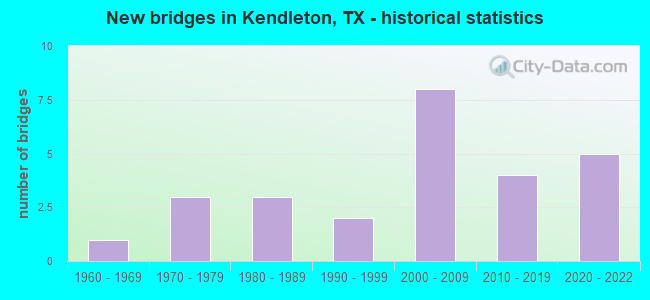
- New bridges - historical statistics
- 11960-1969
- 31970-1979
- 31980-1989
- 21990-1999
- 82000-2009
- 42010-2019
- 52020-2022

- Reconstructed bridges - Historical Statistics
- 22010-2019
- 12020-2022


- Bridge Condition - Deck
- 14.3%Excellent
- 19.0%Very good
- 47.6%Good
- 14.3%Satisfactory
- 4.8%Fair

- Bridge Condition - Superstructure
- 23.8%Excellent
- 33.3%Very good
- 33.3%Good
- 9.5%Satisfactory

- Bridge Condition - Substructure
- 47.6%Very good
- 42.9%Good
- 9.5%Satisfactory

- Bridge Condition - Channel
- 25.0%Very good
- 65.0%Good
- 5.0%Satisfactory
- 5.0%Fair

- Bridge Condition - Culverts
- 50.0%Good
- 50.0%Satisfactory
Find on map >> Show street view
Structure Number: 120800008909078, Location: 0.60 MI SW OF FM 2919 (Lat: 29.437322, Lng: -96.016639), Route carried "on" structure: US 59, Year Built: 1969, Status: Open, Structure Length: 29.26m (96.00ft), Average Daily Traffic: 12,896 (year 2019), Truck Traffic: 22%, Average Future Daily Traffic: 17,810 (year 2039), Design Load: HS 20, Features Intersected: SAN BERNARD RIVER
Minimum Vertical Clearance: 30+ m (98+ ft), Kilometerpoint: 51.222, Lanes on structure: 2, Owner: State Highway Agency, Approaching Roadway Width: 12.2m (40.0ft), Material/Design: Concrete, Design/Construction: Stringer/Multi-beam, Number Of Spans In Main Unit: 24, Length of Maximum Span: 12.2m (40.0ft), Curb-To-Curb Width: 12.2m (40.0ft), Out-to-Out Width: 12.7m (41.7ft)
Condition: Deck: Fair, Superstructure: Satisfactory, Substructure: Satisfactory, Channel: Good, Operating Rating: 54.4 metric tons, Method Used To Determine Operating Rating: Allowable Stress (AS), Inventory Rating: 32.7 metric tons, Method Used To Determine Inventory Rating: Allowable Stress (AS), Structural Evaluation: Equal to present minimum criteria, Deck Geometry: Better than present minimum criteria, Waterway Adequacy: Equal to present minimum criteria, Approach Roadway Alignment: Equal to present desirable criteria, Length Of Structure Improvement: 29.26m (96.00ft), Designated Inspection Frequency: Every 24 months, Inspection Date: October 2020, Deck Structure Type: Concrete Cast-file-Place
Find on map >> Show street view
Structure Number: 120800008909184, Location: 0.40 MI NE OF FM 2919 (Lat: 29.449289, Lng: -95.993300), Route carried "on" structure: US 59, Year Built: 1977, Year Reconstructed: 2019, Status: Open, Structure Length: 4.02m (13.19ft), Average Daily Traffic: 12,841 (year 2019), Truck Traffic: 22%, Average Future Daily Traffic: 19,400 (year 2033), Design Load: HS 20, Features Intersected: Brooks Branch
Minimum Vertical Clearance: 30+ m (98+ ft), Kilometerpoint: 48.544, Lanes on structure: 2, Owner: State Highway Agency, Approaching Roadway Width: 7.9m (25.9ft), Skew: 3 degrees, Material/Design: Concrete, Design/Construction: Stringer/Multi-beam, Number Of Spans In Main Unit: 4, Length of Maximum Span: 10.1m (33.1ft), Curb-To-Curb Width: 7.9m (25.9ft), Out-to-Out Width: 13.5m (44.3ft)
Condition: Deck: Satisfactory, Superstructure: Good, Substructure: Good, Channel: Good, Operating Rating: 54.4 metric tons, Method Used To Determine Operating Rating: Allowable Stress (AS), Inventory Rating: 32.7 metric tons, Method Used To Determine Inventory Rating: Allowable Stress (AS), Structural Evaluation: Better than present minimum criteria, Deck Geometry: High priority of replacement, Waterway Adequacy: Equal to present minimum criteria, Approach Roadway Alignment: Equal to present desirable criteria, Designated Inspection Frequency: Every 24 months, Inspection Date: October 2020, Deck Structure Type: Concrete Cast-file-Place
Find on map >> Show street view
Structure Number: 120800008909185, Location: 0.40 MI NE OF FM 2919 (Lat: 29.449742, Lng: -95.993275), Route carried "on" structure: US 59, Year Built: 1977, Year Reconstructed: 2019, Status: Open, Structure Length: 4.02m (13.19ft), Average Daily Traffic: 12,186 (year 2019), Truck Traffic: 22%, Average Future Daily Traffic: 19,400 (year 2033), Design Load: HS 20, Features Intersected: Brooks Branch
Minimum Vertical Clearance: 30+ m (98+ ft), Kilometerpoint: 48.544, Lanes on structure: 2, Owner: State Highway Agency, Approaching Roadway Width: 7.9m (25.9ft), Skew: 3 degrees, Material/Design: Concrete, Design/Construction: Stringer/Multi-beam, Number Of Spans In Main Unit: 4, Length of Maximum Span: 10.1m (33.1ft), Curb-To-Curb Width: 7.9m (25.9ft), Out-to-Out Width: 13.5m (44.3ft)
Condition: Deck: Satisfactory, Superstructure: Satisfactory, Substructure: Good, Channel: Good, Operating Rating: 54.4 metric tons, Method Used To Determine Operating Rating: Allowable Stress (AS), Inventory Rating: 32.7 metric tons, Method Used To Determine Inventory Rating: Allowable Stress (AS), Structural Evaluation: Equal to present minimum criteria, Deck Geometry: High priority of replacement, Waterway Adequacy: Equal to present minimum criteria, Approach Roadway Alignment: Equal to present desirable criteria, Designated Inspection Frequency: Every 24 months, Inspection Date: October 2020, Deck Structure Type: Concrete Cast-file-Place
Find on map >> Show street view
Structure Number: 120800008909186, Location: 2.50 MI NE OF FM 2919 (Lat: 29.467583, Lng: -95.965525), Route carried "on" structure: US 59, Year Built: 1977, Year Reconstructed: 2020, Status: Open, Structure Length: 0.88m (2.89ft), Average Daily Traffic: 24,160 (year 2020), Truck Traffic: 14%, Average Future Daily Traffic: 42,110 (year 2033), Features Intersected: DRAINAGE DITCH
Minimum Vertical Clearance: 30+ m (98+ ft), Kilometerpoint: 45.189, Lanes on structure: 6, Owner: State Highway Agency, Approaching Roadway Width: 39.6m (129.9ft), Material/Design: Concrete, Design/Construction: Culvert, Number Of Spans In Main Unit: 3, Length of Maximum Span: 2.7m (8.9ft)
Condition: Channel: Good, Culverts: Good, Operating Rating: 32.7 metric tons, Method Used To Determine Operating Rating: Field evaluation and documented engineering judgment, Inventory Rating: 24.5 metric tons, Method Used To Determine Inventory Rating: Field evaluation and documented engineering judgment, Structural Evaluation: Equal to present minimum criteria, Waterway Adequacy: Better than present minimum criteria, Approach Roadway Alignment: Equal to present desirable criteria, Designated Inspection Frequency: Every 24 months, Inspection Date: October 2020
Find on map >> Show street view
Structure Number: 120800008909196, Location: 2.70 MI NE of FM 2919 (Lat: 29.469008, Lng: -95.963122), Route carried "on" structure: ServiceUS 59, Year Built: 1981, Status: Open, Structure Length: 4.63m (15.19ft), Average Daily Traffic: 1,427 (year 2018), Truck Traffic: 8%, Average Future Daily Traffic: 1,998 (year 2038), Design Load: HS 20, Features Intersected: Turkey Creek
Minimum Vertical Clearance: 30+ m (98+ ft), Kilometerpoint: 44.875, Lanes on structure: 2, Owner: State Highway Agency, Approaching Roadway Width: 9.8m (32.2ft), Material/Design: Concrete, Design/Construction: Stringer/Multi-beam, Number Of Spans In Main Unit: 5, Length of Maximum Span: 9.1m (29.9ft), Curb-To-Curb Width: 11.0m (36.1ft), Out-to-Out Width: 11.5m (37.7ft)
Condition: Deck: Good, Superstructure: Good, Substructure: Good, Channel: Satisfactory, Operating Rating: 54.4 metric tons, Method Used To Determine Operating Rating: Load Factor (LF), Inventory Rating: 32.7 metric tons, Method Used To Determine Inventory Rating: Load Factor (LF), Structural Evaluation: Better than present minimum criteria, Deck Geometry: Equal to present minimum criteria, Waterway Adequacy: Equal to present minimum criteria, Approach Roadway Alignment: Equal to present desirable criteria, Designated Inspection Frequency: Every 24 months, Inspection Date: September 2020, Deck Structure Type: Concrete Cast-file-Place
Find on map >> Show street view
Structure Number: 120800008909201, Location: 0.40 MI NE OF FM 2919 (Lat: 29.449064, Lng: -95.993308), Route carried "on" structure: ServiceUS 59, Year Built: 1981, Status: Open, Structure Length: 4.02m (13.19ft), Average Daily Traffic: 1,520 (year 2013), Truck Traffic: 14%, Average Future Daily Traffic: 2,130 (year 2033), Design Load: HS 20, Features Intersected: Brooks Branch
Minimum Vertical Clearance: 30+ m (98+ ft), Kilometerpoint: 48.572, Lanes on structure: 2, Owner: State Highway Agency, Approaching Roadway Width: 9.8m (32.2ft), Skew: 3 degrees, Material/Design: Concrete, Design/Construction: Stringer/Multi-beam, Number Of Spans In Main Unit: 4, Length of Maximum Span: 10.1m (33.1ft), Curb-To-Curb Width: 11.0m (36.1ft), Out-to-Out Width: 11.6m (38.1ft)
Condition: Deck: Good, Superstructure: Good, Substructure: Good, Channel: Good, Operating Rating: 54.4 metric tons, Method Used To Determine Operating Rating: Allowable Stress (AS), Inventory Rating: 32.7 metric tons, Method Used To Determine Inventory Rating: Allowable Stress (AS), Structural Evaluation: Better than present minimum criteria, Deck Geometry: Equal to present minimum criteria, Waterway Adequacy: Better than present minimum criteria, Approach Roadway Alignment: Equal to present desirable criteria, Designated Inspection Frequency: Every 24 months, Inspection Date: October 2020, Deck Structure Type: Concrete Cast-file-Place
Find on map >> Show street view
Structure Number: 120800008909204, Location: 0.6 MI SW OF FM 2919 (Lat: 29.437931, Lng: -96.016092), Route carried "on" structure: US 59, Year Built: 1996, Status: Open, Structure Length: 39.62m (129.99ft), Average Daily Traffic: 12,547 (year 2019), Truck Traffic: 14%, Average Future Daily Traffic: 19,890 (year 2033), Design Load: HS 20, Features Intersected: SAN BERNARD RIVER
Minimum Vertical Clearance: 30+ m (98+ ft), Kilometerpoint: 51.037, Lanes on structure: 2, Owner: State Highway Agency, Approaching Roadway Width: 12.2m (40.0ft), Material/Design: Prestressed concrete, Design/Construction: Stringer/Multi-beam, Number Of Spans In Main Unit: 26, Length of Maximum Span: 15.2m (49.9ft), Curb-To-Curb Width: 11.6m (38.1ft), Out-to-Out Width: 12.4m (40.7ft)
Condition: Deck: Good, Superstructure: Very good, Substructure: Good, Channel: Good, Operating Rating: 54.4 metric tons, Method Used To Determine Operating Rating: Assigned rating based on Load Factor Design (LFD) reported in metric tons, Inventory Rating: 32.7 metric tons, Method Used To Determine Inventory Rating: Assigned rating based on Load Factor Design (LFD) reported in metric tons, Structural Evaluation: Better than present minimum criteria, Deck Geometry: Better than present minimum criteria, Waterway Adequacy: Superior to present desirable criteria, Approach Roadway Alignment: Equal to present desirable criteria, Length Of Structure Improvement: 39.62m (129.99ft), Designated Inspection Frequency: Every 24 months, Inspection Date: October 2020, Deck Structure Type: Concrete Cast-file-Place
Find on map >> Show street view
Structure Number: 120800008909208, Location: 13.6 Mi S of SH 36 (Lat: 29.445894, Lng: -95.999908), Route carried "on" structure: US 59, Year Built: 2008, Status: Open, Structure Length: 9.14m (29.99ft), Average Daily Traffic: 12,841 (year 2019), Truck Traffic: 15%, Average Future Daily Traffic: 19,400 (year 2033), Design Load: HS 25 or greater, Features Intersected: FM 2919
Minimum Vertical Clearance: 30+ m (98+ ft), Kilometerpoint: 49.161, Lanes on structure: 2, Lanes under structure: 5, Owner: State Highway Agency, Approaching Roadway Width: 12.8m (42.0ft), Material/Design: Prestressed concrete, Design/Construction: Stringer/Multi-beam, Number Of Spans In Main Unit: 3, Length of Maximum Span: 36.6m (120.1ft), Curb-To-Curb Width: 18.2m (59.7ft), Out-to-Out Width: 19.0m (62.3ft)
Condition: Deck: Good, Superstructure: Good, Substructure: Good, Operating Rating: 68.0 metric tons, Method Used To Determine Operating Rating: Assigned rating based on Load Factor Design (LFD) reported in metric tons, Inventory Rating: 40.8 metric tons, Method Used To Determine Inventory Rating: Assigned rating based on Load Factor Design (LFD) reported in metric tons, Structural Evaluation: Better than present minimum criteria, Deck Geometry: Superior to present desirable criteria, Underclear: Superior to present desirable criteria, Approach Roadway Alignment: Equal to present desirable criteria, Designated Inspection Frequency: Every 24 months, Inspection Date: October 2020, Deck Structure Type: Concrete Precast Panels
Find on map >> Show street view
Structure Number: 120800008909209, Location: 13.6 Mi S of SH 36 (Lat: 29.446636, Lng: -95.999347), Route carried "on" structure: US 59, Year Built: 2008, Status: Open, Structure Length: 9.14m (29.99ft), Average Daily Traffic: 12,186 (year 2019), Truck Traffic: 15%, Average Future Daily Traffic: 19,400 (year 2033), Design Load: HS 25 or greater, Features Intersected: FM 2919
Minimum Vertical Clearance: 30+ m (98+ ft), Kilometerpoint: 49.159, Lanes on structure: 2, Lanes under structure: 5, Owner: State Highway Agency, Approaching Roadway Width: 14.6m (47.9ft), Material/Design: Prestressed concrete, Design/Construction: Stringer/Multi-beam, Number Of Spans In Main Unit: 3, Length of Maximum Span: 36.6m (120.1ft), Curb-To-Curb Width: 18.2m (59.7ft), Out-to-Out Width: 19.0m (62.3ft)
Condition: Deck: Good, Superstructure: Good, Substructure: Very good, Operating Rating: 68.0 metric tons, Method Used To Determine Operating Rating: Assigned rating based on Load Factor Design (LFD) reported in metric tons, Inventory Rating: 40.8 metric tons, Method Used To Determine Inventory Rating: Assigned rating based on Load Factor Design (LFD) reported in metric tons, Structural Evaluation: Better than present minimum criteria, Deck Geometry: Superior to present desirable criteria, Underclear: Superior to present desirable criteria, Approach Roadway Alignment: Equal to present desirable criteria, Designated Inspection Frequency: Every 24 months, Inspection Date: October 2020, Deck Structure Type: Concrete Precast Panels
Find on map >> Show street view
Structure Number: 120800008909215, Location: 2.70 MI NE FM 2919 (Lat: 29.469906, Lng: -95.963261), Route carried "on" structure: ServiceUS 59, Year Built: 2009, Status: Open, Structure Length: 4.57m (14.99ft), Average Daily Traffic: 12,602 (year 2020), Truck Traffic: 14%, Average Future Daily Traffic: 21,050 (year 2033), Design Load: HL 93, Features Intersected: Turkey Creek
Minimum Vertical Clearance: 30+ m (98+ ft), Kilometerpoint: 45.007, Lanes on structure: 2, Owner: State Highway Agency, Approaching Roadway Width: 12.2m (40.0ft), Material/Design: Prestressed concrete, Number Of Spans In Main Unit: 5, Length of Maximum Span: 9.1m (29.9ft), Curb-To-Curb Width: 12.2m (40.0ft), Out-to-Out Width: 12.9m (42.3ft)
Condition: Deck: Good, Superstructure: Very good, Substructure: Very good, Channel: Good, Operating Rating: 54.4 metric tons, Method Used To Determine Operating Rating: Assigned ratings based on Load and Resistance Factor Design (LRFD) reported in metric tons, Inventory Rating: 32.7 metric tons, Method Used To Determine Inventory Rating: Assigned ratings based on Load and Resistance Factor Design (LRFD) reported in metric tons, Structural Evaluation: Equal to present desirable criteria, Deck Geometry: Better than present minimum criteria, Waterway Adequacy: Superior to present desirable criteria, Approach Roadway Alignment: Equal to present desirable criteria, Designated Inspection Frequency: Every 24 months, Inspection Date: December 2020, Deck Structure Type: Concrete Cast-file-Place
Find on map >> Show street view
Structure Number: 120800008909224, Location: 2.70 Mi NE of FM 2919 (Lat: 29.469719, Lng: -95.963097), Route carried "on" structure: US 59, Year Built: 2018, Status: Open, Structure Length: 5.40m (17.72ft), Average Daily Traffic: 12,393 (year 2019), Truck Traffic: 11%, Average Future Daily Traffic: 17,350 (year 2039), Design Load: HL 93, Features Intersected: Turkey Creek
Minimum Vertical Clearance: 30+ m (98+ ft), Kilometerpoint: 44.870, Lanes on structure: 2, Base Highway Network: Yes, Owner: State Highway Agency, Approaching Roadway Width: 14.6m (47.9ft), Material/Design: Prestressed concrete, Design/Construction: Stringer/Multi-beam, Number Of Spans In Main Unit: 3, Length of Maximum Span: 20.4m (66.9ft), Curb-To-Curb Width: 18.4m (60.4ft), Out-to-Out Width: 19.0m (62.3ft)
Condition: Deck: Good, Superstructure: Very good, Substructure: Very good, Channel: Good, Operating Rating: 54.4 metric tons, Method Used To Determine Operating Rating: Assigned ratings based on Load and Resistance Factor Design (LRFD) reported in metric tons, Inventory Rating: 32.7 metric tons, Method Used To Determine Inventory Rating: Assigned ratings based on Load and Resistance Factor Design (LRFD) reported in metric tons, Structural Evaluation: Equal to present desirable criteria, Deck Geometry: Superior to present desirable criteria, Waterway Adequacy: Superior to present desirable criteria, Approach Roadway Alignment: Equal to present desirable criteria, Designated Inspection Frequency: Every 24 months, Inspection Date: September 2020, Deck Structure Type: Concrete Precast Panels
Find on map >> Show street view
Structure Number: 120800008909225, Location: 1.87 MI SW of FM 360 (Lat: 29.469175, Lng: -95.963369), Route carried "on" structure: Interstate 59, Year Built: 2019, Status: Open, Structure Length: 5.40m (17.72ft), Average Daily Traffic: 12,393 (year 2019), Truck Traffic: 11%, Average Future Daily Traffic: 17,350 (year 2039), Design Load: HL 93, Features Intersected: Turkey Creek
Minimum Vertical Clearance: 30+ m (98+ ft), Kilometerpoint: 0.000, Lanes on structure: 3, Base Highway Network: Yes, Owner: State Highway Agency, Approaching Roadway Width: 18.3m (60.0ft), Material/Design: Prestressed concrete, Design/Construction: Stringer/Multi-beam, Number Of Spans In Main Unit: 1, Number Of Approach Spans: 2, Length of Maximum Span: 20.4m (66.9ft), Curb-To-Curb Width: 18.3m (60.0ft), Out-to-Out Width: 19.0m (62.3ft)
Condition: Deck: Very good, Superstructure: Excellent, Substructure: Very good, Channel: Good, Operating Rating: 54.4 metric tons, Method Used To Determine Operating Rating: Assigned ratings based on Load and Resistance Factor Design (LRFD) reported in metric tons, Inventory Rating: 32.7 metric tons, Method Used To Determine Inventory Rating: Assigned ratings based on Load and Resistance Factor Design (LRFD) reported in metric tons, Structural Evaluation: Equal to present desirable criteria, Deck Geometry: Better than present minimum criteria, Waterway Adequacy: Superior to present desirable criteria, Approach Roadway Alignment: Equal to present desirable criteria, Designated Inspection Frequency: Every 24 months, Inspection Date: September 2020, Deck Structure Type: Concrete Cast-file-Place, Wearing Surface/Protective System: Wearing Surface: Monolithic Concrete
Find on map >> Show street view
Structure Number: 120800008909226, Location: 2.5 MI NE of FM 2919 (Lat: 29.467569, Lng: -95.964422), Route carried "on" structure: City street , Year Built: 2021, Status: Open, Structure Length: 4.57m (14.99ft), Average Daily Traffic: 110 (year 2019), Truck Traffic: 6%, Average Future Daily Traffic: 120 (year 2039), Design Load: HL 93, Features Intersected: Turkey Creek, Facility Carried by Structure: US 59 Access Rd
Minimum Vertical Clearance: 30+ m (98+ ft), Kilometerpoint: 45.189, Lanes on structure: 2, Owner: State Highway Agency, Approaching Roadway Width: 14.0m (45.9ft), Material/Design: Prestressed concrete, Design/Construction: Stringer/Multi-beam, Number Of Spans In Main Unit: 3, Length of Maximum Span: 18.3m (60.0ft), Curb-To-Curb Width: 14.0m (45.9ft), Out-to-Out Width: 14.8m (48.6ft)
Condition: Deck: Excellent, Superstructure: Excellent, Substructure: Very good, Channel: Very good, Operating Rating: 54.4 metric tons, Method Used To Determine Operating Rating: Assigned ratings based on Load and Resistance Factor Design (LRFD) reported in metric tons, Inventory Rating: 32.7 metric tons, Method Used To Determine Inventory Rating: Assigned ratings based on Load and Resistance Factor Design (LRFD) reported in metric tons, Structural Evaluation: Equal to present desirable criteria, Deck Geometry: Superior to present desirable criteria, Waterway Adequacy: Equal to present desirable criteria, Approach Roadway Alignment: Equal to present desirable criteria, Designated Inspection Frequency: Every 24 months, Inspection Date: April 2021, Deck Structure Type: Concrete Precast Panels, Wearing Surface/Protective System: Wearing Surface: Monolithic Concrete, Deck Protection: Epoxy Coated Reinforcing
Find on map >> Show street view
Structure Number: 120800008909227, Location: 2.47 MI NE of FM 2919 (Lat: 29.467811, Lng: -95.966958), Route carried "on" structure: ServiceUS 59, Year Built: 2021, Status: Open, Structure Length: 14.63m (48.00ft), Average Daily Traffic: 6,197 (year 2019), Truck Traffic: 6%, Average Future Daily Traffic: 8,675 (year 2039), Design Load: HL 93, Features Intersected: ROW
Minimum Vertical Clearance: 30+ m (98+ ft), Kilometerpoint: 45.189, Lanes on structure: 2, Owner: State Highway Agency, Approaching Roadway Width: 11.0m (36.1ft), Material/Design: Prestressed concrete, Design/Construction: Stringer/Multi-beam, Number Of Spans In Main Unit: 4, Length of Maximum Span: 36.6m (120.1ft), Curb-To-Curb Width: 11.0m (36.1ft), Out-to-Out Width: 11.7m (38.4ft)
Condition: Deck: Excellent, Superstructure: Excellent, Substructure: Very good, Operating Rating: 54.4 metric tons, Method Used To Determine Operating Rating: Assigned ratings based on Load and Resistance Factor Design (LRFD) reported in metric tons, Inventory Rating: 32.7 metric tons, Method Used To Determine Inventory Rating: Assigned ratings based on Load and Resistance Factor Design (LRFD) reported in metric tons, Structural Evaluation: Equal to present desirable criteria, Deck Geometry: Somewhat better than minimum adequacy, Approach Roadway Alignment: Equal to present desirable criteria, Designated Inspection Frequency: Every 24 months, Inspection Date: April 2021, Deck Structure Type: Concrete Precast Panels, Wearing Surface/Protective System: Wearing Surface: Monolithic Concrete, Deck Protection: Epoxy Coated Reinforcing
Find on map >> Show street view
Structure Number: 120800008909228, Location: At Doris Rd over US 59 (Lat: 29.465914, Lng: -95.964758), Route carried "on" structure: City street , Year Built: 2021, Status: Open, Structure Length: 46.88m (153.81ft), Average Daily Traffic: 110 (year 2019), Truck Traffic: 3%, Average Future Daily Traffic: 120 (year 2039), Design Load: HL 93, Features Intersected: US 59 & KCS RR, Facility Carried by Structure: Doris Rd
Minimum Vertical Clearance: 30+ m (98+ ft), Kilometerpoint: 45.189, Lanes on structure: 4, Lanes under structure: 6, Owner: State Highway Agency, Approaching Roadway Width: 25.1m (82.3ft), Material/Design: Prestressed concrete, Design/Construction: Stringer/Multi-beam, Number Of Spans In Main Unit: 12, Number Of Approach Spans: 1, Length of Maximum Span: 44.2m (145.0ft), Curb-To-Curb Width: 24.4m (80.1ft), Out-to-Out Width: 25.1m (82.3ft)
Condition: Deck: Very good, Superstructure: Excellent, Substructure: Very good, Channel: Very good, Operating Rating: 54.4 metric tons, Method Used To Determine Operating Rating: Assigned ratings based on Load and Resistance Factor Design (LRFD) reported in metric tons, Inventory Rating: 32.7 metric tons, Method Used To Determine Inventory Rating: Assigned ratings based on Load and Resistance Factor Design (LRFD) reported in metric tons, Structural Evaluation: Equal to present desirable criteria, Deck Geometry: Superior to present desirable criteria, Underclear: High priority of corrective action, Waterway Adequacy: Superior to present desirable criteria, Approach Roadway Alignment: Equal to present desirable criteria, Designated Inspection Frequency: Every 24 months, Inspection Date: April 2021, Deck Structure Type: Concrete Precast Panels, Wearing Surface/Protective System: Wearing Surface: Monolithic Concrete, Deck Protection: Epoxy Coated Reinforcing
Find on map >> Show street view
Structure Number: 120800008909229, Location: 2.58 MI NE of FM 2919 (Lat: 29.468486, Lng: -95.965806), Route carried "on" structure: ServiceUS 59, Year Built: 2021, Status: Open, Structure Length: 18.29m (60.01ft), Average Daily Traffic: 6,197 (year 2019), Truck Traffic: 6%, Average Future Daily Traffic: 8,675 (year 2039), Design Load: HL 93, Features Intersected: Drainage Ditch
Minimum Vertical Clearance: 30+ m (98+ ft), Kilometerpoint: 45.189, Lanes on structure: 2, Owner: State Highway Agency, Approaching Roadway Width: 11.0m (36.1ft), Material/Design: Prestressed concrete, Design/Construction: Stringer/Multi-beam, Number Of Spans In Main Unit: 5, Length of Maximum Span: 36.6m (120.1ft), Curb-To-Curb Width: 11.0m (36.1ft), Out-to-Out Width: 11.7m (38.4ft)
Condition: Deck: Excellent, Superstructure: Excellent, Substructure: Very good, Channel: Very good, Operating Rating: 54.4 metric tons, Method Used To Determine Operating Rating: Assigned ratings based on Load and Resistance Factor Design (LRFD) reported in metric tons, Inventory Rating: 32.7 metric tons, Method Used To Determine Inventory Rating: Assigned ratings based on Load and Resistance Factor Design (LRFD) reported in metric tons, Structural Evaluation: Equal to present desirable criteria, Deck Geometry: Somewhat better than minimum adequacy, Waterway Adequacy: Superior to present desirable criteria, Approach Roadway Alignment: Equal to present desirable criteria, Designated Inspection Frequency: Every 24 months, Inspection Date: April 2021, Deck Structure Type: Concrete Precast Panels, Wearing Surface/Protective System: Wearing Surface: Monolithic Concrete, Deck Protection: Epoxy Coated Reinforcing
Find on map >> Show street view
Structure Number: 120800008917216, Location: 0.5 MI NE OF FM 2919 (Lat: 29.451931, Lng: -95.993000), Route carried "on" structure: State highway 541, Year Built: 2009, Status: Open, Structure Length: 2.62m (8.60ft), Average Daily Traffic: 1,193 (year 2016), Truck Traffic: 21%, Average Future Daily Traffic: 800 (year 2030), Design Load: HL 93, Features Intersected: Brooks Branch
Minimum Vertical Clearance: 30+ m (98+ ft), Kilometerpoint: 20.798, Lanes on structure: 2, Owner: State Highway Agency, Approaching Roadway Width: 12.2m (40.0ft), Material/Design: Prestressed concrete, Number Of Spans In Main Unit: 3, Length of Maximum Span: 9.1m (29.9ft), Curb-To-Curb Width: 12.2m (40.0ft), Out-to-Out Width: 12.8m (42.0ft)
Condition: Deck: Good, Superstructure: Very good, Substructure: Very good, Channel: Good, Operating Rating: 54.4 metric tons, Method Used To Determine Operating Rating: Assigned ratings based on Load and Resistance Factor Design (LRFD) reported in metric tons, Inventory Rating: 32.7 metric tons, Method Used To Determine Inventory Rating: Assigned ratings based on Load and Resistance Factor Design (LRFD) reported in metric tons, Structural Evaluation: Equal to present desirable criteria, Deck Geometry: Better than present minimum criteria, Waterway Adequacy: Equal to present desirable criteria, Approach Roadway Alignment: Equal to present desirable criteria, Designated Inspection Frequency: Every 24 months, Inspection Date: October 2020, Deck Structure Type: Concrete Cast-file-Place
Find on map >> Show street view
Structure Number: 120800AA0892001, Location: 0.40 MI NE OF FM 2919 (Lat: 29.465292, Lng: -96.006133), Route carried "on" structure: County highway , Year Built: 1999, Status: Open, Structure Length: 1.22m (4.00ft), Average Daily Traffic: 90 (year 2010), Average Future Daily Traffic: 150 (year 2030), Design Load: HS 20, Features Intersected: BROOKS BRANCH, Facility Carried by Structure: PINK-TAYLOR RUN RD
Minimum Vertical Clearance: 30+ m (98+ ft), Kilometerpoint: 0.644, Lanes on structure: 2, Owner: County Highway Agency, Approaching Roadway Width: 6.7m (22.0ft), Material/Design: Steel, Design/Construction: Stringer/Multi-beam, Number Of Spans In Main Unit: 1, Length of Maximum Span: 12.2m (40.0ft), Curb-To-Curb Width: 7.9m (25.9ft), Out-to-Out Width: 8.5m (27.9ft)
Condition: Deck: Good, Superstructure: Good, Substructure: Good, Channel: Good, Operating Rating: 68.9 metric tons, Method Used To Determine Operating Rating: Load Factor (LF), Inventory Rating: 40.8 metric tons, Method Used To Determine Inventory Rating: Load Factor (LF), Structural Evaluation: Better than present minimum criteria, Deck Geometry: Equal to present minimum criteria, Waterway Adequacy: Better than present minimum criteria, Approach Roadway Alignment: Equal to present desirable criteria, Designated Inspection Frequency: Every 24 months, Inspection Date: September 2021, Deck Structure Type: Concrete Cast-file-Place
Find on map >> Show street view
Structure Number: 120800AA0893001, Location: 0.45 MI NE OF FM 2919 (Lat: 29.460769, Lng: -96.003828), Route carried "on" structure: County highway , Year Built: 2009, Status: Posted for load, Structure Length: 1.40m (4.59ft), Average Daily Traffic: 10 (year 2009), Average Future Daily Traffic: 50 (year 2029), Features Intersected: BROOKS BRANCH, Facility Carried by Structure: KING RD
Minimum Vertical Clearance: 30+ m (98+ ft), Kilometerpoint: 0.724, Lanes on structure: 1, Owner: County Highway Agency, Approaching Roadway Width: 5.5m (18.0ft), Material/Design: Wood or Timber, Design/Construction: Stringer/Multi-beam, Number Of Spans In Main Unit: 3, Length of Maximum Span: 4.6m (15.1ft), Curb-To-Curb Width: 4.5m (14.8ft), Out-to-Out Width: 5.0m (16.4ft)
Condition: Deck: Good, Superstructure: Good, Substructure: Good, Channel: Good, Operating Rating: 29.9 metric tons, Method Used To Determine Operating Rating: Allowable Stress (AS), Inventory Rating: 21.8 metric tons, Method Used To Determine Inventory Rating: Allowable Stress (AS), Structural Evaluation: Equal to present minimum criteria, Deck Geometry: Equal to present minimum criteria, Waterway Adequacy: Better than present minimum criteria, Approach Roadway Alignment: Equal to present desirable criteria, Bridge Posting: Required (Relationship of Operating Rating to Maximum Legal Load: 30.0 - 39.9% below), Designated Inspection Frequency: Every 24 months, Inspection Date: September 2021, Deck Structure Type: Wood or Timber, Wearing Surface/Protective System: Wearing Surface: Wood or Timber
Find on map >> Show street view
Structure Number: 120800AA0968001, Location: 2.10 MI SE OF US 59 (Lat: 29.437003, Lng: -95.957833), Route carried "on" structure: County highway , Year Built: 1987, Status: Open, Structure Length: 2.74m (8.99ft), Average Daily Traffic: 80 (year 2009), Average Future Daily Traffic: 110 (year 2029), Features Intersected: TURKEY CREEK, Facility Carried by Structure: DARST RD
Minimum Vertical Clearance: 30+ m (98+ ft), Kilometerpoint: 3.380, Lanes on structure: 2, Owner: County Highway Agency, Approaching Roadway Width: 6.1m (20.0ft), Material/Design: Prestressed concrete, Design/Construction: Box Beam or Girders - Multiple, Number Of Spans In Main Unit: 3, Length of Maximum Span: 9.1m (29.9ft), Curb-To-Curb Width: 8.0m (26.2ft), Out-to-Out Width: 8.7m (28.5ft)
Condition: Deck: Satisfactory, Superstructure: Very good, Substructure: Satisfactory, Channel: Fair, Operating Rating: 32.7 metric tons, Method Used To Determine Operating Rating: Field evaluation and documented engineering judgment, Inventory Rating: 24.5 metric tons, Method Used To Determine Inventory Rating: Field evaluation and documented engineering judgment, Structural Evaluation: Equal to present minimum criteria, Deck Geometry: Equal to present minimum criteria, Waterway Adequacy: Better than present minimum criteria, Approach Roadway Alignment: Equal to present minimum criteria, Designated Inspection Frequency: Every 24 months, Inspection Date: September 2021, Deck Structure Type: Concrete Cast-file-Place
Find on map >> Show street view
Structure Number: 120800J00010005, Location: 0.55 MI NE OF FM 2919 (Lat: 29.452811, Lng: -95.993319), Route carried "on" structure: City street , Year Built: 2016, Status: Open, Structure Length: 1.52m (4.99ft), Design Load: HL 93, Features Intersected: BROOKS BRANCH, Facility Carried by Structure: BRAXTON ROAD
Minimum Vertical Clearance: 30+ m (98+ ft), Kilometerpoint: 0.885, Lanes on structure: 2, Owner: Town or Township Highway Agency, Approaching Roadway Width: 7.3m (24.0ft), Material/Design: Prestressed concrete, Number Of Spans In Main Unit: 1, Length of Maximum Span: 15.2m (49.9ft), Curb or Sidewalk Widths: Left: 0.0m, Right: 1.8m (5.9ft), Curb-To-Curb Width: 7.3m (24.0ft), Out-to-Out Width: 9.8m (32.2ft)
Condition: Deck: Very good, Superstructure: Very good, Substructure: Good, Channel: Very good, Operating Rating: 54.4 metric tons, Method Used To Determine Operating Rating: Assigned ratings based on Load and Resistance Factor Design (LRFD) reported in metric tons, Inventory Rating: 32.7 metric tons, Method Used To Determine Inventory Rating: Assigned ratings based on Load and Resistance Factor Design (LRFD) reported in metric tons, Structural Evaluation: Better than present minimum criteria, Deck Geometry: Equal to present minimum criteria, Waterway Adequacy: Superior to present desirable criteria, Approach Roadway Alignment: Equal to present desirable criteria, Designated Inspection Frequency: Every 24 months, Inspection Date: October 2021, Deck Structure Type: Concrete Cast-file-Place
Find on map >> Show street view
Structure Number: 132410AA0216001, Location: 2.71 MI E OF US 59 (Lat: 29.404175, Lng: -96.007450), Route carried "on" structure: County highway 216, Year Built: 2006, Status: Open, Structure Length: 0.91m (2.99ft), Average Daily Traffic: 310 (year 2014), Average Future Daily Traffic: 400 (year 2034), Features Intersected: BOONE BRANCH
Minimum Vertical Clearance: 30+ m (98+ ft), Kilometerpoint: 4.361, Lanes on structure: 2, Owner: County Highway Agency, Approaching Roadway Width: 6.4m (21.0ft), Material/Design: Steel, Design/Construction: Culvert, Number Of Spans In Main Unit: 3, Length of Maximum Span: 2.4m (7.9ft)
Condition: Channel: Good, Culverts: Satisfactory, Operating Rating: 32.7 metric tons, Method Used To Determine Operating Rating: Field evaluation and documented engineering judgment, Inventory Rating: 24.5 metric tons, Method Used To Determine Inventory Rating: Field evaluation and documented engineering judgment, Structural Evaluation: Equal to present minimum criteria, Waterway Adequacy: Better than present minimum criteria, Approach Roadway Alignment: Equal to present desirable criteria, Designated Inspection Frequency: Every 24 months, Inspection Date: May 2020
Find on map >> Show street view
Structure Number: 132410AA0225005, Location: 3.22 MI N OF CR 117 (Lat: 29.398061, Lng: -96.018331), Route carried "on" structure: County highway 225, Year Built: 2018, Status: Open, Structure Length: 1.52m (4.99ft), Average Daily Traffic: 480 (year 2014), Truck Traffic: 2%, Average Future Daily Traffic: 600 (year 2034), Design Load: HL 93, Features Intersected: DRAW
Minimum Vertical Clearance: 30+ m (98+ ft), Kilometerpoint: 518.209, Lanes on structure: 2, Owner: County Highway Agency, Approaching Roadway Width: 7.3m (24.0ft), Material/Design: Prestressed concrete, Number Of Spans In Main Unit: 1, Length of Maximum Span: 15.2m (49.9ft), Curb-To-Curb Width: 9.1m (29.9ft), Out-to-Out Width: 9.8m (32.2ft)
Condition: Deck: Very good, Superstructure: Very good, Substructure: Very good, Channel: Very good, Operating Rating: 54.4 metric tons, Method Used To Determine Operating Rating: Assigned ratings based on Load and Resistance Factor Design (LRFD) reported in metric tons, Inventory Rating: 32.7 metric tons, Method Used To Determine Inventory Rating: Assigned ratings based on Load and Resistance Factor Design (LRFD) reported in metric tons, Structural Evaluation: Equal to present desirable criteria, Deck Geometry: Equal to present minimum criteria, Waterway Adequacy: Better than present minimum criteria, Approach Roadway Alignment: Equal to present desirable criteria, Designated Inspection Frequency: Every 24 months, Inspection Date: May 2020, Deck Structure Type: Concrete Cast-file-Place
Find on map >> Show street view
Structure Number: 120800008909208, Location: 13.6 Mi S of SH 36 (Lat: 29.445894, Lng: -95.999908), Route carried "under" structure: State highway 2919, Year Built: 2008, Structure Length: 0. m, Average Daily Traffic: 1,200 (year 2010), Truck Traffic: 5%, Features Intersected: FM 2919, Facility Carried by Structure: US 59 NB
Minimum Vertical Clearance: 5.33m (17.49ft), Kilometerpoint: 0.002, Lanes on structure: 2, Lanes under structure: 5, Material/Design: Prestressed concrete, Design/Construction: Stringer/Multi-beam, Length of Maximum Span: 36.6m (120.1ft)
Find on map >> Show street view
Structure Number: 120800008909209, Location: 13.6 Mi S of SH 36 (Lat: 29.446636, Lng: -95.999347), Route carried "under" structure: State highway 2919, Year Built: 2008, Structure Length: 0. m, Average Daily Traffic: 1,200 (year 2010), Truck Traffic: 5%, Features Intersected: FM 2919, Facility Carried by Structure: US 59 SB
Minimum Vertical Clearance: 5.56m (18.24ft), Kilometerpoint: 0.002, Lanes on structure: 2, Lanes under structure: 5, Material/Design: Prestressed concrete, Design/Construction: Stringer/Multi-beam, Length of Maximum Span: 36.6m (120.1ft)
Find on map >> Show street view
Structure Number: 120800008909228, Location: At Doris Rd over US 59 (Lat: 29.459792, Lng: -95.978842), Route carried "under" structure: US 59, Year Built: 2021, Structure Length: 0. m, Average Daily Traffic: 24,785 (year 2019), Truck Traffic: 22%, Features Intersected: NA, Facility Carried by Structure: Doris Rd
Minimum Vertical Clearance: 6.98m (22.90ft), Kilometerpoint: 45.189, Lanes on structure: 6, Material/Design: Prestressed concrete, Design/Construction: Stringer/Multi-beam, Length of Maximum Span: 44.2m (145.0ft)