Bridge Statistics for Kent, Ohio (OH)
Condition, Traffic, Stress, Structural Evaluation, Project Costs
- National Bridge Inventory (NBI) Statistics
- 28Number of bridges
- 469ft / 143mTotal length
- 198,941Total average daily traffic
- 14,053Total average daily truck traffic
- National Bridge Inventory (NBI) Registered Bridges for Kent
- No street view available for this location
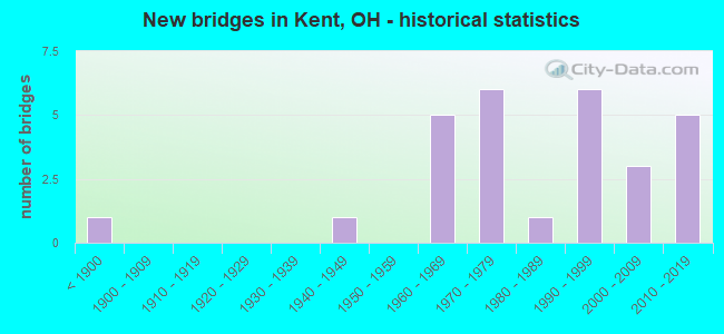
- New bridges - historical statistics
- 1Before 1900
- 11940-1949
- 51960-1969
- 61970-1979
- 11980-1989
- 61990-1999
- 32000-2009
- 52010-2019

- Reconstructed bridges - Historical Statistics
- 11970-1979
- 31980-1989
- 01990-1999
- 02000-2009
- 12010-2019


- Bridge Condition - Deck
- 22.7%Excellent
- 18.2%Very good
- 31.8%Good
- 18.2%Satisfactory
- 4.5%Fair
- 4.5%Serious

- Bridge Condition - Superstructure
- 21.7%Excellent
- 26.1%Very good
- 30.4%Good
- 8.7%Satisfactory
- 4.3%Fair
- 8.7%Poor

- Bridge Condition - Substructure
- 21.7%Excellent
- 30.4%Very good
- 34.8%Good
- 4.3%Satisfactory
- 4.3%Fair
- 4.3%Poor

- Bridge Condition - Channel
- 9.5%Excellent
- 19.0%Very good
- 42.9%Good
- 23.8%Satisfactory
- 4.8%Fair

- Bridge Condition - Culverts
- 50.0%Good
- 50.0%Serious
Find on map >> Show street view
Structure Number: 6701132, Location: 0.79 MI E OF SR 261 (Lat: 41.151161, Lng: -81.359531), Route carried "on" structure: State highway 43, Year Built: 1975, Status: Open, Structure Length: 23.23m (76.21ft), Average Daily Traffic: 21,120 (year 2015), Truck Traffic: 4%, Average Future Daily Traffic: 29,315 (year 2035), Design Load: HS 20, Features Intersected: CUY RIV, CSXT, FRANKLIN
Minimum Vertical Clearance: 30+ m (98+ ft), Kilometerpoint: 18.540, Lanes on structure: 4, Lanes under structure: 2, Base Highway Network: Yes, Owner: State Highway Agency, Approaching Roadway Width: 15.9m (52.2ft), Skew: 3 degrees, Material/Design: Steel continuous, Design/Construction: Stringer/Multi-beam, Number Of Spans In Main Unit: 9, Length of Maximum Span: 31.4m (103.0ft), Curb or Sidewalk Widths: Left: 1.5m (4.9ft), Right: 0.6m (2.0ft), Curb-To-Curb Width: 15.9m (52.2ft), Out-to-Out Width: 18.6m (61.0ft)
Condition: Deck: Good, Superstructure: Good, Substructure: Good, Channel: Very good, Operating Rating: 42.1 metric tons, Method Used To Determine Operating Rating: Load Factor (LF) rating reported by rating factor (RF) method using MS18 loading, Inventory Rating: 29.2 metric tons, Method Used To Determine Inventory Rating: Load Factor (LF) rating reported by rating factor (RF) method using MS18 loading, Structural Evaluation: Better than present minimum criteria, Deck Geometry: Meets minimum limits, Underclear: Superior to present desirable criteria, Waterway Adequacy: Better than present minimum criteria, Approach Roadway Alignment: Equal to present desirable criteria, Designated Inspection Frequency: Every 24 months, Inspection Date: May 2021, Deck Structure Type: Concrete Cast-file-Place, Wearing Surface/Protective System: Wearing Surface: Integral Concrete
Find on map >> Show street view
Structure Number: 670176, Location: 0.80 MI E OF SR 43 (Lat: 41.150781, Lng: -81.373481), Route carried "on" structure: State highway 59, Year Built: 1975, Status: Open, Structure Length: 12.47m (40.91ft), Average Daily Traffic: 16,834 (year 2015), Truck Traffic: 6%, Average Future Daily Traffic: 23,366 (year 2035), Design Load: HS 20, Features Intersected: OVER TALLMADGE AV,W&LE R
Minimum Vertical Clearance: 30+ m (98+ ft), Kilometerpoint: 1.625, Lanes on structure: 4, Lanes under structure: 2, Base Highway Network: Yes, Owner: State Highway Agency, Approaching Roadway Width: 20.1m (65.9ft), Material/Design: Steel continuous, Design/Construction: Stringer/Multi-beam, Number Of Spans In Main Unit: 4, Length of Maximum Span: 36.3m (119.1ft), Curb-To-Curb Width: 20.3m (66.6ft), Out-to-Out Width: 21.3m (69.9ft)
Condition: Deck: Good, Superstructure: Good, Substructure: Good, Operating Rating: 42.1 metric tons, Method Used To Determine Operating Rating: Allowable Stress (AS) rating reported by rating factor (RF) method using MS18 loading, Inventory Rating: 32.4 metric tons, Method Used To Determine Inventory Rating: Allowable Stress (AS) rating reported by rating factor (RF) method using MS18 loading, Structural Evaluation: Better than present minimum criteria, Deck Geometry: Equal to present desirable criteria, Underclear: Superior to present desirable criteria, Approach Roadway Alignment: Better than present minimum criteria, Designated Inspection Frequency: Every 24 months, Inspection Date: April 2021, Deck Structure Type: Concrete Cast-file-Place, Wearing Surface/Protective System: Wearing Surface: Integral Concrete
Find on map >> Show street view
Structure Number: 6702163, Location: 2.38 MI W OF SR 5 (Lat: 41.109900, Lng: -81.288019), Route carried "on" structure: County highway C0151, Year Built: 1964, Year Reconstructed: 2010, Status: Open, Structure Length: 6.92m (22.70ft), Average Daily Traffic: 465 (year 2015), Truck Traffic: 3%, Average Future Daily Traffic: 60,161 (year 2035), Design Load: HS 25 or greater, Features Intersected: IR 76, Facility Carried by Structure: LAKEWOOD ROAD
Minimum Vertical Clearance: 30+ m (98+ ft), Kilometerpoint: 0.998, Lanes on structure: 2, Lanes under structure: 4, Owner: State Highway Agency, Approaching Roadway Width: 7.3m (24.0ft), Skew: 1 degrees, Material/Design: Steel continuous, Design/Construction: Stringer/Multi-beam, Number Of Spans In Main Unit: 4, Length of Maximum Span: 18.0m (59.1ft), Curb-To-Curb Width: 7.3m (24.0ft), Out-to-Out Width: 9.4m (30.8ft)
Condition: Deck: Very good, Superstructure: Very good, Substructure: Very good, Operating Rating: 61.6 metric tons, Method Used To Determine Operating Rating: Load and Resistance Factor Rating (LRFR) rating reported by rating factor(RF) method using HL-93 loadings, Inventory Rating: 48.6 metric tons, Method Used To Determine Inventory Rating: Load and Resistance Factor Rating (LRFR) rating reported by rating factor(RF) method using HL-93 loadings, Structural Evaluation: Equal to present desirable criteria, Deck Geometry: Meets minimum limits, Underclear: High priority of corrective action, Approach Roadway Alignment: Equal to present desirable criteria, Designated Inspection Frequency: Every 24 months, Inspection Date: March 2021, Deck Structure Type: Concrete Cast-file-Place, Wearing Surface/Protective System: Wearing Surface: Monolithic Concrete, Deck Protection: Epoxy Coated Reinforcing
Find on map >> Show street view
Structure Number: 6704964, Location: 0.82 MI W OF SR 43 (Lat: 41.134861, Lng: -81.369689), Route carried "on" structure: State highway 261, Year Built: 1975, Status: Open, Structure Length: 16.40m (53.81ft), Average Daily Traffic: 4,732 (year 2015), Truck Traffic: 3%, Average Future Daily Traffic: 6,568 (year 2035), Design Load: HS 20, Features Intersected: PLUM CREEK & W&LE RR
Minimum Vertical Clearance: 30+ m (98+ ft), Kilometerpoint: 1.915, Lanes on structure: 2, Base Highway Network: Yes, Owner: State Highway Agency, Approaching Roadway Width: 11.6m (38.1ft), Material/Design: Steel continuous, Design/Construction: Stringer/Multi-beam, Number Of Spans In Main Unit: 10, Length of Maximum Span: 21.3m (69.9ft), Curb-To-Curb Width: 11.7m (38.4ft), Out-to-Out Width: 12.8m (42.0ft)
Condition: Deck: Satisfactory, Superstructure: Very good, Substructure: Very good, Channel: Very good, Operating Rating: 42.1 metric tons, Method Used To Determine Operating Rating: Load Factor (LF) rating reported by rating factor (RF) method using MS18 loading, Inventory Rating: 32.4 metric tons, Method Used To Determine Inventory Rating: Load Factor (LF) rating reported by rating factor (RF) method using MS18 loading, Structural Evaluation: Equal to present desirable criteria, Deck Geometry: Better than present minimum criteria, Underclear: Equal to present desirable criteria, Waterway Adequacy: Equal to present desirable criteria, Approach Roadway Alignment: Better than present minimum criteria, Designated Inspection Frequency: Every 12 months, Inspection Date: May 2021, Deck Structure Type: Concrete Cast-file-Place, Wearing Surface/Protective System: Wearing Surface: Integral Concrete
Find on map >> Show street view
Structure Number: 6704972, Location: 0.82 MI W OF SR 43 (Lat: 41.134561, Lng: -81.369650), Route carried "on" structure: State highway 261, Year Built: 1975, Status: Open, Structure Length: 16.40m (53.81ft), Average Daily Traffic: 4,732 (year 2015), Truck Traffic: 3%, Average Future Daily Traffic: 6,568 (year 2035), Design Load: HS 20, Features Intersected: PLUM CREEK & W&LE RR
Minimum Vertical Clearance: 30+ m (98+ ft), Kilometerpoint: 1.915, Lanes on structure: 2, Base Highway Network: Yes, Owner: State Highway Agency, Approaching Roadway Width: 11.6m (38.1ft), Material/Design: Steel continuous, Design/Construction: Stringer/Multi-beam, Number Of Spans In Main Unit: 11, Length of Maximum Span: 21.3m (69.9ft), Curb-To-Curb Width: 11.7m (38.4ft), Out-to-Out Width: 12.8m (42.0ft)
Condition: Deck: Satisfactory, Superstructure: Very good, Substructure: Very good, Channel: Very good, Operating Rating: 42.1 metric tons, Method Used To Determine Operating Rating: Load Factor (LF) rating reported by rating factor (RF) method using MS18 loading, Inventory Rating: 32.4 metric tons, Method Used To Determine Inventory Rating: Load Factor (LF) rating reported by rating factor (RF) method using MS18 loading, Structural Evaluation: Equal to present desirable criteria, Deck Geometry: Better than present minimum criteria, Underclear: Equal to present minimum criteria, Waterway Adequacy: Equal to present desirable criteria, Approach Roadway Alignment: Better than present minimum criteria, Designated Inspection Frequency: Every 12 months, Inspection Date: May 2021, Deck Structure Type: Concrete Cast-file-Place, Wearing Surface/Protective System: Wearing Surface: Integral Concrete
Find on map >> Show street view
Structure Number: 6730582, Location: 0.57 MI S. OF JCT SR 261 (Lat: 41.126531, Lng: -81.366161), Route carried "on" structure: City street SUNBK, Year Built: 1940, Year Reconstructed: 1987, Status: Open, Structure Length: 1.19m (3.90ft), Average Daily Traffic: 794 (year 2015), Truck Traffic: 5%, Average Future Daily Traffic: 1,102 (year 2035), Design Load: HS 20, Features Intersected: PLUM CREEK, Facility Carried by Structure: SUNNY BROOK RD
Minimum Vertical Clearance: 30+ m (98+ ft), Kilometerpoint: 1.048, Lanes on structure: 2, Owner: County Highway Agency, Approaching Roadway Width: 5.8m (19.0ft), Material/Design: Steel, Design/Construction: Stringer/Multi-beam, Number Of Spans In Main Unit: 1, Length of Maximum Span: 10.4m (34.1ft), Curb-To-Curb Width: 6.4m (21.0ft), Out-to-Out Width: 6.6m (21.7ft)
Condition: Deck: Fair, Superstructure: Poor, Substructure: Good, Channel: Satisfactory, Operating Rating: 42.1 metric tons, Method Used To Determine Operating Rating: Allowable Stress (AS) rating reported by rating factor (RF) method using MS18 loading, Inventory Rating: 32.4 metric tons, Method Used To Determine Inventory Rating: Allowable Stress (AS) rating reported by rating factor (RF) method using MS18 loading, Structural Evaluation: Meets minimum limits, Deck Geometry: High priority of corrective action, Waterway Adequacy: Better than present minimum criteria, Approach Roadway Alignment: Meets minimum limits, Designated Inspection Frequency: Every 12 months, Inspection Date: August 2021, Deck Structure Type: Corrugated Steel, Wearing Surface/Protective System: Wearing Surface: Bituminous
Find on map >> Show street view
Structure Number: 6730914, Location: PLUM CREEK (Lat: 41.117781, Lng: -81.367219), Route carried "on" structure: County highway T083B, Year Built: 1963, Status: Open, Structure Length: 1.31m (4.30ft), Average Daily Traffic: 2,020 (year 2015), Truck Traffic: 5%, Average Future Daily Traffic: 2,804 (year 2035), Design Load: H 20, Features Intersected: PLUM CREEK, Facility Carried by Structure: HOWE RD
Minimum Vertical Clearance: 30+ m (98+ ft), Kilometerpoint: 0.943, Lanes on structure: 2, Owner: County Highway Agency, Approaching Roadway Width: 6.1m (20.0ft), Material/Design: Steel, Design/Construction: Stringer/Multi-beam, Number Of Spans In Main Unit: 1, Length of Maximum Span: 12.5m (41.0ft), Curb-To-Curb Width: 6.2m (20.3ft), Out-to-Out Width: 6.2m (20.3ft)
Condition: Deck: Satisfactory, Superstructure: Poor, Substructure: Good, Channel: Satisfactory, Operating Rating: 42.1 metric tons, Method Used To Determine Operating Rating: Allowable Stress (AS) rating reported by rating factor (RF) method using MS18 loading, Inventory Rating: 32.4 metric tons, Method Used To Determine Inventory Rating: Allowable Stress (AS) rating reported by rating factor (RF) method using MS18 loading, Structural Evaluation: Meets minimum limits, Deck Geometry: High priority of replacement, Waterway Adequacy: Equal to present minimum criteria, Approach Roadway Alignment: Equal to present minimum criteria, Designated Inspection Frequency: Every 12 months, Inspection Date: August 2021, Deck Structure Type: Corrugated Steel, Wearing Surface/Protective System: Wearing Surface: Bituminous
Find on map >> Show street view
Structure Number: 6731287, Location: TR 162A (Lat: 41.164619, Lng: -81.336000), Route carried "on" structure: County highway C162A, Year Built: 2010, Status: Open, Structure Length: 5.18m (16.99ft), Average Daily Traffic: 4,267 (year 2015), Truck Traffic: 3%, Average Future Daily Traffic: 5,923 (year 2035), Design Load: HS 25 or greater, Features Intersected: BREAKNECK CREEK, Facility Carried by Structure: BRADY LAKE RD
Minimum Vertical Clearance: 30+ m (98+ ft), Kilometerpoint: 0.156, Lanes on structure: 2, Owner: County Highway Agency, Approaching Roadway Width: 9.1m (29.9ft), Skew: 3 degrees, Material/Design: Prestressed concrete, Design/Construction: Box Beam or Girders - Multiple, Number Of Spans In Main Unit: 2, Length of Maximum Span: 25.3m (83.0ft), Curb-To-Curb Width: 11.6m (38.1ft), Out-to-Out Width: 12.2m (40.0ft)
Condition: Deck: Excellent, Superstructure: Excellent, Substructure: Very good, Channel: Excellent, Operating Rating: 38.9 metric tons, Method Used To Determine Operating Rating: Load Factor (LF) rating reported by rating factor (RF) method using MS18 loading, Inventory Rating: 32.4 metric tons, Method Used To Determine Inventory Rating: Load Factor (LF) rating reported by rating factor (RF) method using MS18 loading, Structural Evaluation: Equal to present desirable criteria, Deck Geometry: Somewhat better than minimum adequacy, Waterway Adequacy: Equal to present desirable criteria, Approach Roadway Alignment: Equal to present minimum criteria, Designated Inspection Frequency: Every 24 months, Inspection Date: September 2021, Deck Structure Type: Concrete Cast-file-Place, Wearing Surface/Protective System: Wearing Surface: Integral Concrete
Find on map >> Show street view
Structure Number: 6731295, Location: 0.2 MI. E. OF CH 85 (Lat: 41.174439, Lng: -81.384169), Route carried "on" structure: County highway T141A, Year Built: 1991, Status: Open, Structure Length: 0.70m (2.30ft), Average Daily Traffic: 983 (year 2015), Truck Traffic: 5%, Average Future Daily Traffic: 1,364 (year 2035), Design Load: H 20, Features Intersected: FISH CREEK, Facility Carried by Structure: JOHNSON RD.-TH141A
Minimum Vertical Clearance: 30+ m (98+ ft), Kilometerpoint: 0.702, Lanes on structure: 2, Owner: County Highway Agency, Approaching Roadway Width: 6.1m (20.0ft), Skew: 1 degrees, Material/Design: Steel, Design/Construction: Culvert, Number Of Spans In Main Unit: 2, Length of Maximum Span: 3.0m (9.8ft)
Condition: Channel: Good, Culverts: Serious, Operating Rating: 48.6 metric tons, Method Used To Determine Operating Rating: Load Factor (LF) rating reported by rating factor (RF) method using MS18 loading, Inventory Rating: 38.9 metric tons, Method Used To Determine Inventory Rating: Load Factor (LF) rating reported by rating factor (RF) method using MS18 loading, Structural Evaluation: High priority of corrective action, Waterway Adequacy: Equal to present desirable criteria, Approach Roadway Alignment: Equal to present minimum criteria, Designated Inspection Frequency: Every 12 months, Inspection Date: September 2021
Find on map >> Show street view
Structure Number: 6733492, Location: 01.0 MI S. OF SR59 (Lat: 41.144439, Lng: -81.307781), Route carried "on" structure: County highway T098B, Year Built: 1996, Status: Open, Structure Length: 2.90m (9.51ft), Average Daily Traffic: 1,914 (year 2015), Truck Traffic: 5%, Average Future Daily Traffic: 2,657 (year 2035), Design Load: HS 20+Mod, Features Intersected: BREAKNECK CREEK, Facility Carried by Structure: POWDER MILL ROAD
Minimum Vertical Clearance: 30+ m (98+ ft), Kilometerpoint: 2.092, Lanes on structure: 2, Owner: County Highway Agency, Approaching Roadway Width: 9.1m (29.9ft), Skew: 3 degrees, Material/Design: Prestressed concrete, Design/Construction: Box Beam or Girders - Multiple, Number Of Spans In Main Unit: 3, Length of Maximum Span: 10.7m (35.1ft), Curb-To-Curb Width: 9.8m (32.2ft), Out-to-Out Width: 9.8m (32.2ft)
Condition: Deck: Good, Superstructure: Satisfactory, Substructure: Excellent, Channel: Good, Operating Rating: 42.1 metric tons, Method Used To Determine Operating Rating: Load Factor (LF) rating reported by rating factor (RF) method using MS18 loading, Inventory Rating: 25.9 metric tons, Method Used To Determine Inventory Rating: Load Factor (LF) rating reported by rating factor (RF) method using MS18 loading, Structural Evaluation: Equal to present minimum criteria, Deck Geometry: Somewhat better than minimum adequacy, Waterway Adequacy: Equal to present desirable criteria, Approach Roadway Alignment: Better than present minimum criteria, Designated Inspection Frequency: Every 12 months, Inspection Date: August 2021, Deck Structure Type: Concrete Cast-file-Place, Wearing Surface/Protective System: Wearing Surface: Bituminous, Membrane: Built-up
Find on map >> Show street view
Structure Number: 6735975, Location: ROCKWELL LAKE OUTLET (Lat: 41.180561, Lng: -81.335561), Route carried "on" structure: County highway C145E, Year Built: 1980, Status: Open, Structure Length: 3.35m (10.99ft), Average Daily Traffic: 1,785 (year 2015), Truck Traffic: 1%, Average Future Daily Traffic: 2,478 (year 2035), Design Load: HS 20, Features Intersected: ROCKWELL LAKE OUTLET, Facility Carried by Structure: RAVENNA RD
Minimum Vertical Clearance: 30+ m (98+ ft), Kilometerpoint: 0.274, Lanes on structure: 2, Owner: County Highway Agency, Approaching Roadway Width: 7.3m (24.0ft), Material/Design: Prestressed concrete, Design/Construction: Box Beam or Girders - Multiple, Number Of Spans In Main Unit: 1, Length of Maximum Span: 32.3m (106.0ft), Curb-To-Curb Width: 8.7m (28.5ft), Out-to-Out Width: 8.7m (28.5ft)
Condition: Deck: Good, Superstructure: Good, Substructure: Good, Channel: Good, Operating Rating: 42.1 metric tons, Method Used To Determine Operating Rating: Load Factor (LF) rating reported by rating factor (RF) method using MS18 loading, Inventory Rating: 32.4 metric tons, Method Used To Determine Inventory Rating: Load Factor (LF) rating reported by rating factor (RF) method using MS18 loading, Structural Evaluation: Better than present minimum criteria, Deck Geometry: Somewhat better than minimum adequacy, Waterway Adequacy: Better than present minimum criteria, Approach Roadway Alignment: High priority of corrective action, Designated Inspection Frequency: Every 24 months, Inspection Date: October 2021, Deck Structure Type: Concrete Cast-file-Place, Wearing Surface/Protective System: Wearing Surface: Bituminous
Find on map >> Show street view
Structure Number: 6736491, Location: 1400' NORTH OF SR 261 (Lat: 41.137800, Lng: -81.390869), Route carried "on" structure: City street CO018, Year Built: 2008, Status: Open, Structure Length: 4.75m (15.58ft), Average Daily Traffic: 2,665 (year 2015), Truck Traffic: 1%, Average Future Daily Traffic: 3,699 (year 2035), Design Load: HS 20+Mod, Features Intersected: CUYAHOGA RIVER, Facility Carried by Structure: MIDDLEBURY RD
Minimum Vertical Clearance: 30+ m (98+ ft), Kilometerpoint: 0.161, Lanes on structure: 2, Owner: County Highway Agency, Approaching Roadway Width: 7.3m (24.0ft), Skew: 2 degrees, Material/Design: Prestressed concrete continuous, Design/Construction: Stringer/Multi-beam, Number Of Spans In Main Unit: 3, Length of Maximum Span: 18.3m (60.0ft), Curb-To-Curb Width: 11.0m (36.1ft), Out-to-Out Width: 12.2m (40.0ft)
Condition: Deck: Excellent, Superstructure: Excellent, Substructure: Excellent, Channel: Very good, Operating Rating: 42.1 metric tons, Method Used To Determine Operating Rating: Load Factor (LF) rating reported by rating factor (RF) method using MS18 loading, Inventory Rating: 32.4 metric tons, Method Used To Determine Inventory Rating: Load Factor (LF) rating reported by rating factor (RF) method using MS18 loading, Structural Evaluation: Equal to present desirable criteria, Deck Geometry: Somewhat better than minimum adequacy, Waterway Adequacy: Equal to present desirable criteria, Approach Roadway Alignment: Equal to present desirable criteria, Designated Inspection Frequency: Every 24 months, Inspection Date: August 2021, Deck Structure Type: Concrete Cast-file-Place, Wearing Surface/Protective System: Wearing Surface: Monolithic Concrete, Deck Protection: Epoxy Coated Reinforcing
Find on map >> Show street view
Structure Number: 673708, Location: 850' EAST OF SR 43 (Lat: 41.153889, Lng: -81.359439), Route carried "on" structure: City street MMAIN, Year Built: 1876, Year Reconstructed: 1978, Status: Open, Structure Length: 7.59m (24.90ft), Average Daily Traffic: 12,977 (year 2015), Truck Traffic: 3%, Average Future Daily Traffic: 18,012 (year 2035), Features Intersected: CUYAHOGA RIVER & CSXT RR, Facility Carried by Structure: WEST MAIN ST.
Minimum Vertical Clearance: 30+ m (98+ ft), Kilometerpoint: 0.016, Lanes on structure: 4, Owner: County Highway Agency, Approaching Roadway Width: 15.2m (49.9ft), Material/Design: Masonry, Design/Construction: Arch - Deck, Number Of Spans In Main Unit: 3, Number Of Approach Spans: 1, Length of Maximum Span: 13.7m (44.9ft), Curb or Sidewalk Widths: Left: 2.1m (6.9ft), Right: 2.1m (6.9ft), Curb-To-Curb Width: 15.2m (49.9ft), Out-to-Out Width: 21.3m (69.9ft)
Condition: Superstructure: Good, Substructure: Poor, Channel: Good, Operating Rating: 97.2 metric tons, Method Used To Determine Operating Rating: Load and Resistance Factor Rating (LRFR) rating reported by rating factor(RF) method using HL-93 loadings, Inventory Rating: 74.5 metric tons, Method Used To Determine Inventory Rating: Load and Resistance Factor Rating (LRFR) rating reported by rating factor(RF) method using HL-93 loadings, Structural Evaluation: Meets minimum limits, Deck Geometry: High priority of corrective action, Underclear: High priority of corrective action, Waterway Adequacy: Equal to present desirable criteria, Approach Roadway Alignment: Better than present minimum criteria, Designated Inspection Frequency: Every 12 months, Inspection Date: October 2021, Deck Structure Type: Concrete Cast-file-Place, Wearing Surface/Protective System: Wearing Surface: Bituminous
Find on map >> Show street view
Structure Number: 6737382, Location: 0.6 MI W.OF SR43 (Lat: 41.161669, Lng: -81.369719), Route carried "on" structure: City street FRCHD, Year Built: 1996, Status: Open, Structure Length: 1.46m (4.79ft), Average Daily Traffic: 10,098 (year 2015), Truck Traffic: 3%, Average Future Daily Traffic: 14,016 (year 2035), Design Load: HS 20+Mod, Features Intersected: FISH CREEK, Facility Carried by Structure: FAIRCHILD AVE
Minimum Vertical Clearance: 30+ m (98+ ft), Kilometerpoint: 0.016, Lanes on structure: 2, Owner: County Highway Agency, Approaching Roadway Width: 7.3m (24.0ft), Material/Design: Prestressed concrete, Design/Construction: Box Beam or Girders - Multiple, Number Of Spans In Main Unit: 1, Length of Maximum Span: 13.4m (44.0ft), Curb or Sidewalk Widths: Left: 1.5m (4.9ft), Right: 1.5m (4.9ft), Curb-To-Curb Width: 11.6m (38.1ft), Out-to-Out Width: 15.2m (49.9ft)
Condition: Deck: Very good, Superstructure: Very good, Substructure: Excellent, Channel: Good, Operating Rating: 45.4 metric tons, Method Used To Determine Operating Rating: Load Factor (LF) rating reported by rating factor (RF) method using MS18 loading, Inventory Rating: 25.9 metric tons, Method Used To Determine Inventory Rating: Load Factor (LF) rating reported by rating factor (RF) method using MS18 loading, Structural Evaluation: Equal to present minimum criteria, Deck Geometry: Somewhat better than minimum adequacy, Waterway Adequacy: Superior to present desirable criteria, Approach Roadway Alignment: Equal to present desirable criteria, Designated Inspection Frequency: Every 24 months, Inspection Date: September 2021, Deck Structure Type: Concrete Cast-file-Place, Wearing Surface/Protective System: Wearing Surface: Integral Concrete, Deck Protection: Epoxy Coated Reinforcing
Find on map >> Show street view
Structure Number: 6737447, Location: 200' E OF SR 43 (Lat: 41.158889, Lng: -81.358889), Route carried "on" structure: County highway C0140, Year Built: 2011, Status: Open, Structure Length: 7.71m (25.30ft), Average Daily Traffic: 22,833 (year 2015), Truck Traffic: 3%, Average Future Daily Traffic: 31,692 (year 2035), Design Load: HS 25 or greater, Features Intersected: CUYAHOGA R, Facility Carried by Structure: FAIRCHILD AVE
Minimum Vertical Clearance: 30+ m (98+ ft), Kilometerpoint: 8.851, Lanes on structure: 2, Owner: County Highway Agency, Approaching Roadway Width: 15.9m (52.2ft), Skew: 1 degrees, Material/Design: Steel continuous, Design/Construction: Stringer/Multi-beam, Number Of Spans In Main Unit: 3, Length of Maximum Span: 41.1m (134.8ft), Curb or Sidewalk Widths: Left: 2.4m (7.9ft), Right: 2.4m (7.9ft), Curb-To-Curb Width: 15.9m (52.2ft), Out-to-Out Width: 20.7m (67.9ft)
Condition: Deck: Excellent, Superstructure: Excellent, Substructure: Excellent, Channel: Excellent, Operating Rating: 48.6 metric tons, Method Used To Determine Operating Rating: Load Factor (LF) rating reported by rating factor (RF) method using MS18 loading, Inventory Rating: 42.1 metric tons, Method Used To Determine Inventory Rating: Load Factor (LF) rating reported by rating factor (RF) method using MS18 loading, Structural Evaluation: Superior to present desirable criteria, Deck Geometry: Superior to present desirable criteria, Waterway Adequacy: Equal to present desirable criteria, Approach Roadway Alignment: Equal to present desirable criteria, Designated Inspection Frequency: Every 24 months, Inspection Date: September 2021, Deck Structure Type: Concrete Cast-file-Place, Wearing Surface/Protective System: Wearing Surface: Monolithic Concrete
Find on map >> Show street view
Structure Number: 6737498, Location: CUYAHOGA RIVER (Lat: 41.150561, Lng: -81.362219), Route carried "on" structure: City street STOW, Year Built: 1966, Year Reconstructed: 1988, Status: Open, Structure Length: 4.30m (14.11ft), Average Daily Traffic: 7,742 (year 2015), Truck Traffic: 5%, Average Future Daily Traffic: 10,746 (year 2035), Design Load: HS 20+Mod, Features Intersected: CUYAHOGA RIVER
Minimum Vertical Clearance: 30+ m (98+ ft), Kilometerpoint: 0.306, Lanes on structure: 2, Owner: County Highway Agency, Approaching Roadway Width: 8.5m (27.9ft), Material/Design: Prestressed concrete, Design/Construction: Box Beam or Girders - Multiple, Number Of Spans In Main Unit: 2, Length of Maximum Span: 21.0m (68.9ft), Curb or Sidewalk Widths: Left: 0.1m (0.3ft), Right: 0.0m, Curb-To-Curb Width: 8.5m (27.9ft), Out-to-Out Width: 10.8m (35.4ft)
Condition: Deck: Satisfactory, Superstructure: Satisfactory, Substructure: Satisfactory, Channel: Good, Operating Rating: 58.3 metric tons, Method Used To Determine Operating Rating: Load Factor (LF) rating reported by rating factor (RF) method using MS18 loading, Inventory Rating: 35.6 metric tons, Method Used To Determine Inventory Rating: Load Factor (LF) rating reported by rating factor (RF) method using MS18 loading, Structural Evaluation: Equal to present minimum criteria, Deck Geometry: High priority of replacement, Waterway Adequacy: Equal to present desirable criteria, Approach Roadway Alignment: Equal to present minimum criteria, Designated Inspection Frequency: Every 12 months, Inspection Date: September 2021, Deck Structure Type: Concrete Cast-file-Place, Wearing Surface/Protective System: Wearing Surface: Bituminous, Membrane: Built-up, Deck Protection: Epoxy Coated Reinforcing
Find on map >> Show street view
Structure Number: 674082, Location: 0.2 MI. NW OF SR 43 (Lat: 41.184381, Lng: -81.342539), Route carried "on" structure: County highway C155B, Year Built: 1992, Status: Open, Structure Length: 3.81m (12.50ft), Average Daily Traffic: 20,574 (year 2015), Truck Traffic: 3%, Average Future Daily Traffic: 28,557 (year 2035), Design Load: HS 20+Mod, Features Intersected: NORFOLK & SOUTHERN R/R, Facility Carried by Structure: DIAGONAL ROAD
Minimum Vertical Clearance: 30+ m (98+ ft), Kilometerpoint: 0.502, Lanes on structure: 2, Owner: County Highway Agency, Approaching Roadway Width: 9.1m (29.9ft), Material/Design: Prestressed concrete, Design/Construction: Box Beam or Girders - Multiple, Number Of Spans In Main Unit: 3, Length of Maximum Span: 14.3m (46.9ft), Curb-To-Curb Width: 9.1m (29.9ft), Out-to-Out Width: 10.1m (33.1ft)
Condition: Deck: Very good, Superstructure: Very good, Substructure: Very good, Operating Rating: 48.6 metric tons, Method Used To Determine Operating Rating: Load Factor (LF) rating reported by rating factor (RF) method using MS18 loading, Inventory Rating: 29.2 metric tons, Method Used To Determine Inventory Rating: Load Factor (LF) rating reported by rating factor (RF) method using MS18 loading, Structural Evaluation: Better than present minimum criteria, Deck Geometry: High priority of corrective action, Underclear: Somewhat better than minimum adequacy, Approach Roadway Alignment: Equal to present minimum criteria, Designated Inspection Frequency: Every 24 months, Inspection Date: September 2021, Deck Structure Type: Concrete Cast-file-Place, Wearing Surface/Protective System: Wearing Surface: Integral Concrete, Deck Protection: Epoxy Coated Reinforcing
Find on map >> Show street view
Structure Number: 6760015, Location: 0.25 MI N.OF SR59 (Lat: 41.156550, Lng: -81.389269), Route carried "on" structure: City street SUNRI, Year Built: 1968, Year Reconstructed: 1988, Status: Posted for load, Structure Length: 1.31m (4.30ft), Average Daily Traffic: 150 (year 1951), Truck Traffic: 5%, Average Future Daily Traffic: 208 (year 1971), Features Intersected: FISH CREEK
Minimum Vertical Clearance: 30+ m (98+ ft), Kilometerpoint: 4.023, Lanes on structure: 2, Owner: City or Municipal Highway Agency, Approaching Roadway Width: 7.9m (25.9ft), Skew: 3 degrees, Material/Design: Steel, Design/Construction: Stringer/Multi-beam, Number Of Spans In Main Unit: 1, Length of Maximum Span: 11.9m (39.0ft), Curb or Sidewalk Widths: Left: 1.3m (4.3ft), Right: 1.3m (4.3ft), Curb-To-Curb Width: 8.0m (26.2ft), Out-to-Out Width: 10.5m (34.4ft)
Condition: Deck: Serious, Superstructure: Fair, Substructure: Fair, Channel: Fair, Operating Rating: 42.1 metric tons, Method Used To Determine Operating Rating: Load Factor (LF) rating reported by rating factor (RF) method using MS18 loading, Inventory Rating: 25.9 metric tons, Method Used To Determine Inventory Rating: Load Factor (LF) rating reported by rating factor (RF) method using MS18 loading, Structural Evaluation: Somewhat better than minimum adequacy, Deck Geometry: Somewhat better than minimum adequacy, Waterway Adequacy: Equal to present minimum criteria, Approach Roadway Alignment: Equal to present minimum criteria, Bridge Posting: Required (Relationship of Operating Rating to Maximum Legal Load: 0.1 - 9.9% below), Designated Inspection Frequency: Every 12 months, Inspection Date: August 2021, Deck Structure Type: Concrete Cast-file-Place, Wearing Surface/Protective System: Wearing Surface: Monolithic Concrete
Find on map >> Show street view
Structure Number: 6760024, Location: 175 FT.E.OF ERIN DR (Lat: 41.167369, Lng: -81.371469), Route carried "on" structure: City street ALLEN, Year Built: 2016, Status: Open, Structure Length: 1.43m (4.69ft), Average Daily Traffic: 620 (year 2016), Truck Traffic: 3%, Average Future Daily Traffic: 2,798 (year 2036), Design Load: HL 93, Features Intersected: FISH CREEK, Facility Carried by Structure: Allen Dr.
Minimum Vertical Clearance: 30+ m (98+ ft), Kilometerpoint: 0.064, Lanes on structure: 2, Owner: City or Municipal Highway Agency, Approaching Roadway Width: 7.6m (24.9ft), Material/Design: Steel, Design/Construction: Stringer/Multi-beam, Number Of Spans In Main Unit: 1, Length of Maximum Span: 13.7m (44.9ft), Curb or Sidewalk Widths: Left: 1.4m (4.6ft), Right: 1.4m (4.6ft), Curb-To-Curb Width: 7.6m (24.9ft), Out-to-Out Width: 11.0m (36.1ft)
Condition: Deck: Excellent, Superstructure: Excellent, Substructure: Excellent, Channel: Good, Operating Rating: 55.1 metric tons, Method Used To Determine Operating Rating: Load and Resistance Factor Rating (LRFR) rating reported by rating factor(RF) method using HL-93 loadings, Inventory Rating: 42.1 metric tons, Method Used To Determine Inventory Rating: Load and Resistance Factor Rating (LRFR) rating reported by rating factor(RF) method using HL-93 loadings, Structural Evaluation: Superior to present desirable criteria, Deck Geometry: Meets minimum limits, Waterway Adequacy: Better than present minimum criteria, Approach Roadway Alignment: Equal to present desirable criteria, Designated Inspection Frequency: Every 24 months, Inspection Date: August 2021, Deck Structure Type: Concrete Cast-file-Place, Wearing Surface/Protective System: Wearing Surface: Monolithic Concrete, Membrane: Epoxy
Find on map >> Show street view
Structure Number: 6760104, Location: 800 FT N OF JCT SR 261 (Lat: 41.136731, Lng: -81.392269), Route carried "on" structure: City street MIDDL, Year Built: 2006, Status: Open, Structure Length: 4.69m (15.39ft), Average Daily Traffic: 2,665 (year 2015), Truck Traffic: 1%, Average Future Daily Traffic: 3,699 (year 2035), Design Load: HS 20, Features Intersected: CSXT RAILROAD
Minimum Vertical Clearance: 30+ m (98+ ft), Kilometerpoint: 0.000, Lanes on structure: 2, Owner: City or Municipal Highway Agency, Approaching Roadway Width: 9.1m (29.9ft), Material/Design: Steel, Design/Construction: Truss - Thru, Number Of Spans In Main Unit: 1, Length of Maximum Span: 45.7m (149.9ft), Curb or Sidewalk Widths: Left: 0.1m (0.3ft), Right: 0.1m (0.3ft), Curb-To-Curb Width: 8.8m (28.9ft), Out-to-Out Width: 9.1m (29.9ft)
Condition: Deck: Very good, Superstructure: Very good, Substructure: Very good, Operating Rating: 51.8 metric tons, Method Used To Determine Operating Rating: Load Factor (LF) rating reported by rating factor (RF) method using MS18 loading, Inventory Rating: 25.9 metric tons, Method Used To Determine Inventory Rating: Load Factor (LF) rating reported by rating factor (RF) method using MS18 loading, Structural Evaluation: Equal to present minimum criteria, Deck Geometry: Meets minimum limits, Underclear: Better than present minimum criteria, Approach Roadway Alignment: Equal to present minimum criteria, Designated Inspection Frequency: Every 12 months, Critical Feature Inspection Frequency: Every 24 months, Inspection Date: August 2021, Critical Feature Inspection Date: September 2020, Deck Structure Type: Concrete Cast-file-Place, Wearing Surface/Protective System: Wearing Surface: Monolithic Concrete, Deck Protection: Epoxy Coated Reinforcing
Find on map >> Show street view
Structure Number: 6760112, Location: 1200 FT N OF JCT SR 59 (Lat: 41.154711, Lng: -81.381411), Route carried "on" structure: City street ADMOR, Year Built: 1992, Status: Open, Structure Length: 2.13m (6.99ft), Average Daily Traffic: 3,100 (year 2007), Truck Traffic: 5%, Average Future Daily Traffic: 4,303 (year 2027), Design Load: HS 20, Features Intersected: FISH CREEK, Facility Carried by Structure: STONEWATER DRIVE
Minimum Vertical Clearance: 30+ m (98+ ft), Kilometerpoint: 0.016, Lanes on structure: 2, Owner: City or Municipal Highway Agency, Approaching Roadway Width: 8.2m (26.9ft), Skew: 2 degrees, Material/Design: Prestressed concrete, Design/Construction: Box Beam or Girders - Multiple, Number Of Spans In Main Unit: 1, Length of Maximum Span: 21.3m (69.9ft), Curb-To-Curb Width: 6.7m (22.0ft), Out-to-Out Width: 8.5m (27.9ft)
Condition: Deck: Good, Superstructure: Good, Substructure: Good, Channel: Satisfactory, Operating Rating: 68.0 metric tons, Method Used To Determine Operating Rating: Load Factor (LF) rating reported by rating factor (RF) method using MS18 loading, Inventory Rating: 42.1 metric tons, Method Used To Determine Inventory Rating: Load Factor (LF) rating reported by rating factor (RF) method using MS18 loading, Structural Evaluation: Better than present minimum criteria, Deck Geometry: High priority of replacement, Waterway Adequacy: Better than present minimum criteria, Approach Roadway Alignment: Somewhat better than minimum adequacy, Designated Inspection Frequency: Every 24 months, Inspection Date: August 2021, Deck Structure Type: Other, Wearing Surface/Protective System: Wearing Surface: Bituminous, Membrane: Built-up
Find on map >> Show street view
Structure Number: 676012, Location: RIVER BEND BLVD (Lat: 41.168581, Lng: -81.346489), Route carried "on" structure: City street RVRBD, Year Built: 1998, Status: Open, Structure Length: 5.64m (18.50ft), Average Daily Traffic: 1,000 (year 2000), Truck Traffic: 2%, Average Future Daily Traffic: 1,388 (year 2020), Design Load: HS 20+Mod, Features Intersected: CUYAHOGA RIVER, Facility Carried by Structure: RIVER BEND BLVD
Minimum Vertical Clearance: 30+ m (98+ ft), Kilometerpoint: 0.000, Lanes on structure: 2, Owner: City or Municipal Highway Agency, Approaching Roadway Width: 7.9m (25.9ft), Material/Design: Prestressed concrete continuous, Design/Construction: Stringer/Multi-beam, Number Of Spans In Main Unit: 3, Length of Maximum Span: 24.4m (80.1ft), Curb or Sidewalk Widths: Left: 1.5m (4.9ft), Right: 0.0m, Curb-To-Curb Width: 7.9m (25.9ft), Out-to-Out Width: 10.2m (33.5ft)
Condition: Deck: Good, Superstructure: Good, Substructure: Good, Channel: Good, Operating Rating: 77.8 metric tons, Method Used To Determine Operating Rating: Load Factor (LF) rating reported by rating factor (RF) method using MS18 loading, Inventory Rating: 42.1 metric tons, Method Used To Determine Inventory Rating: Load Factor (LF) rating reported by rating factor (RF) method using MS18 loading, Structural Evaluation: Better than present minimum criteria, Deck Geometry: Somewhat better than minimum adequacy, Waterway Adequacy: Superior to present desirable criteria, Approach Roadway Alignment: Equal to present desirable criteria, Designated Inspection Frequency: Every 24 months, Inspection Date: August 2021, Deck Structure Type: Concrete Cast-file-Place, Wearing Surface/Protective System: Wearing Surface: Monolithic Concrete, Deck Protection: Epoxy Coated Reinforcing
Find on map >> Show street view
Structure Number: 6760236, Location: 0.35 MI. N O FSR261 (Lat: 41.139719, Lng: -81.371669), Route carried "on" structure: City street MOGAD, Year Built: 2010, Status: Open, Structure Length: 1.04m (3.41ft), Average Daily Traffic: 5,295 (year 2015), Truck Traffic: 5%, Average Future Daily Traffic: 7,349 (year 2035), Design Load: HL 93, Features Intersected: PLUM CREEK
Minimum Vertical Clearance: 30+ m (98+ ft), Kilometerpoint: 0.161, Lanes on structure: 2, Owner: City or Municipal Highway Agency, Approaching Roadway Width: 7.9m (25.9ft), Material/Design: Concrete, Design/Construction: Culvert, Number Of Spans In Main Unit: 1, Length of Maximum Span: 9.8m (32.2ft)
Condition: Channel: Satisfactory, Culverts: Good, Operating Rating: 32.4 metric tons, Method Used To Determine Operating Rating: Load and Resistance Factor Rating (LRFR) rating reported by rating factor(RF) method using HL-93 loadings, Inventory Rating: 25.9 metric tons, Method Used To Determine Inventory Rating: Load and Resistance Factor Rating (LRFR) rating reported by rating factor(RF) method using HL-93 loadings, Structural Evaluation: Equal to present minimum criteria, Waterway Adequacy: Superior to present desirable criteria, Approach Roadway Alignment: Superior to present desirable criteria, Designated Inspection Frequency: Every 24 months, Inspection Date: August 2021
Find on map >> Show street view
Structure Number: 6760287, Location: 440 FT S OF STOW ST (Lat: 41.149661, Lng: -81.367100), Route carried "on" structure: City street FULLR, Year Built: 2013, Status: Open, Structure Length: 5.40m (17.72ft), Average Daily Traffic: 264 (year 2014), Truck Traffic: 5%, Average Future Daily Traffic: 2,795 (year 2034), Design Load: HL 93, Features Intersected: CUYAHOGA RIVER, Facility Carried by Structure: FRED FULLER PARK
Minimum Vertical Clearance: 30+ m (98+ ft), Kilometerpoint: 0.966, Lanes on structure: 1, Owner: City or Municipal Highway Agency, Approaching Roadway Width: 6.1m (20.0ft), Material/Design: Steel continuous, Design/Construction: Stringer/Multi-beam, Number Of Spans In Main Unit: 3, Length of Maximum Span: 22.3m (73.2ft), Curb or Sidewalk Widths: Left: 2.3m (7.5ft), Right: 0.5m (1.6ft), Curb-To-Curb Width: 3.4m (11.2ft), Out-to-Out Width: 6.1m (20.0ft)
Condition: Deck: Excellent, Superstructure: Excellent, Substructure: Good, Channel: Good, Operating Rating: 55.1 metric tons, Method Used To Determine Operating Rating: Load and Resistance Factor Rating (LRFR) rating reported by rating factor(RF) method using HL-93 loadings, Inventory Rating: 42.1 metric tons, Method Used To Determine Inventory Rating: Load and Resistance Factor Rating (LRFR) rating reported by rating factor(RF) method using HL-93 loadings, Structural Evaluation: Better than present minimum criteria, Deck Geometry: High priority of replacement, Waterway Adequacy: Equal to present desirable criteria, Approach Roadway Alignment: Equal to present minimum criteria, Designated Inspection Frequency: Every 24 months, Inspection Date: August 2021, Deck Structure Type: Concrete Cast-file-Place, Wearing Surface/Protective System: Wearing Surface: Monolithic Concrete, Deck Protection: Epoxy Coated Reinforcing
Find on map >> Show street view
Structure Number: 6760317, Location: 0.2 MI N OF JCT SR 59 (Lat: 41.154011, Lng: -81.386750), Route carried "on" structure: City street SPLDG, Year Built: 2009, Status: Open, Structure Length: 1.59m (5.22ft), Average Daily Traffic: 800 (year 2009), Truck Traffic: 10%, Average Future Daily Traffic: 1,110 (year 2029), Design Load: HS 20+Mod, Features Intersected: FISH CREEK, Facility Carried by Structure: SPAULDING BLVD
Minimum Vertical Clearance: 30+ m (98+ ft), Kilometerpoint: 2.092, Lanes on structure: 2, Owner: City or Municipal Highway Agency, Approaching Roadway Width: 7.9m (25.9ft), Material/Design: Prestressed concrete, Design/Construction: Box Beam or Girders - Multiple, Number Of Spans In Main Unit: 1, Length of Maximum Span: 14.6m (47.9ft), Curb or Sidewalk Widths: Left: 2.1m (6.9ft), Right: 2.1m (6.9ft), Curb-To-Curb Width: 7.9m (25.9ft), Out-to-Out Width: 12.8m (42.0ft)
Condition: Deck: Good, Superstructure: Good, Substructure: Very good, Channel: Satisfactory, Operating Rating: 87.5 metric tons, Method Used To Determine Operating Rating: Load Factor (LF) rating reported by rating factor (RF) method using MS18 loading, Inventory Rating: 51.8 metric tons, Method Used To Determine Inventory Rating: Load Factor (LF) rating reported by rating factor (RF) method using MS18 loading, Structural Evaluation: Better than present minimum criteria, Deck Geometry: Somewhat better than minimum adequacy, Waterway Adequacy: Superior to present desirable criteria, Approach Roadway Alignment: Equal to present minimum criteria, Designated Inspection Frequency: Every 24 months, Inspection Date: August 2021, Deck Structure Type: Concrete Cast-file-Place, Wearing Surface/Protective System: Wearing Surface: Monolithic Concrete, Deck Protection: Epoxy Coated Reinforcing
Find on map >> Show street view
Structure Number: 6701132, Location: 0.79 MI E OF SR 261 (Lat: 41.151161, Lng: -81.359531), Route carried "under" structure: County highway 501, Year Built: 1975, Structure Length: 0. m, Average Daily Traffic: 4,868 (year 2015), Truck Traffic: 5%, Features Intersected: SR 43, Facility Carried by Structure: SR 43, SR 59
Minimum Vertical Clearance: 5.26m (17.26ft), Kilometerpoint: 1.094, Lanes on structure: 4, Lanes under structure: 2, Material/Design: Steel continuous, Design/Construction: Stringer/Multi-beam, Length of Maximum Span: 31.4m (103.0ft)
Find on map >> Show street view
Structure Number: 670176, Location: 0.80 MI E OF SR 43 (Lat: 41.150781, Lng: -81.373481), Route carried "under" structure: Business City street TALMG, Year Built: 1975, Structure Length: 0. m, Average Daily Traffic: 300 (year 1990), Truck Traffic: 3%, Features Intersected: SR 59, Facility Carried by Structure: SR 59
Minimum Vertical Clearance: 6.10m (20.01ft), Kilometerpoint: 0.048, Lanes on structure: 4, Lanes under structure: 2, Material/Design: Steel continuous, Design/Construction: Stringer/Multi-beam, Length of Maximum Span: 36.3m (119.1ft)
Find on map >> Show street view
Structure Number: 6702163, Location: 2.38 MI W OF SR 5 (Lat: 41.109900, Lng: -81.288019), Route carried "under" structure: Interstate 76, Year Built: 1964, Structure Length: 0. m, Average Daily Traffic: 43,344 (year 2015), Truck Traffic: 19%, Features Intersected: UNDER LAKEWOOD RD CR-151, Facility Carried by Structure: LAKEWOOD ROAD
Minimum Vertical Clearance: 5.03m (16.50ft), Kilometerpoint: 9.914, Lanes on structure: 2, Lanes under structure: 4, Material/Design: Steel continuous, Design/Construction: Stringer/Multi-beam, Length of Maximum Span: 18.0m (59.1ft)