Bridge Statistics for Keysville, Virginia (VA)
Condition, Traffic, Stress, Structural Evaluation, Project Costs
- National Bridge Inventory (NBI) Statistics
- 19Number of bridges
- 164ft / 49.9mTotal length
- $4,206,000Total costs
- 35,213Total average daily traffic
- 4,319Total average daily truck traffic
- National Bridge Inventory (NBI) Registered Bridges for Keysville
- No street view available for this location
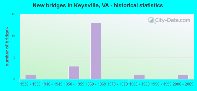
- New bridges - historical statistics
- 11930-1939
- 31950-1959
- 131960-1969
- 11980-1989
- 12000-2009

- Reconstructed bridges - Historical Statistics
- 11990-1999
- 22000-2009


- Bridge Condition - Deck
- 18.2%Very good
- 63.6%Good
- 18.2%Fair

- Bridge Condition - Superstructure
- 9.1%Very good
- 54.5%Good
- 9.1%Satisfactory
- 18.2%Fair
- 9.1%Poor

- Bridge Condition - Substructure
- 27.3%Good
- 54.5%Satisfactory
- 18.2%Fair

- Bridge Condition - Channel
- 28.6%Good
- 42.9%Satisfactory
- 28.6%Fair

- Bridge Condition - Culverts
- 50.0%Good
- 50.0%Fair
Find on map >> Show street view
Structure Number: 4822, Location: 0.21 to 360 - 0.06 to 712 (Lat: 37.063806, Lng: -78.470367), Route carried "on" structure: Bypass US 15, Year Built: 1965, Year Reconstructed: 2009, Status: Open, Structure Length: 6.62m (21.72ft), Average Daily Traffic: 4,167 (year 2020), Truck Traffic: 7%, Average Future Daily Traffic: 4,968 (year 2040), Design Load: HS 20, Features Intersected: Routes 15 & 360 Byp.
Minimum Vertical Clearance: 30+ m (98+ ft), Kilometerpoint: 68.720, Lanes on structure: 2, Lanes under structure: 4, Owner: State Highway Agency, Approaching Roadway Width: 9.1m (29.9ft), Skew: 1 degrees, Material/Design: Steel, Design/Construction: Stringer/Multi-beam, Number Of Spans In Main Unit: 2, Number Of Approach Spans: 2, Length of Maximum Span: 21.3m (69.9ft), Curb or Sidewalk Widths: Left: 0.5m (1.6ft), Right: 0.5m (1.6ft), Curb-To-Curb Width: 9.8m (32.2ft), Out-to-Out Width: 10.8m (35.4ft)
Condition: Deck: Good, Superstructure: Good, Substructure: Good, Operating Rating: 80.7 metric tons, Method Used To Determine Operating Rating: Load and Resistance Factor (LRFR), Inventory Rating: 62.6 metric tons, Method Used To Determine Inventory Rating: Load and Resistance Factor (LRFR), Structural Evaluation: Better than present minimum criteria, Deck Geometry: Meets minimum limits, Underclear: Meets minimum limits, Approach Roadway Alignment: Equal to present desirable criteria, Designated Inspection Frequency: Every 24 months, Inspection Date: April 2020, Deck Structure Type: Concrete Cast-file-Place, Wearing Surface/Protective System: Wearing Surface: Latex Concrete
Find on map >> Show street view
Structure Number: 4825, Location: 1.40-Rt.622/0.80-Rt.629 (Lat: 37.008358, Lng: -78.484311), Route carried "on" structure: Bypass US 15, Year Built: 1966, Status: Open, Structure Length: 9.12m (29.92ft), Average Daily Traffic: 2,186 (year 2020), Truck Traffic: 16%, Average Future Daily Traffic: 3,058 (year 2040), Design Load: HS 20+Mod, Features Intersected: Rt 15 & 360 Bu; BB RWY, Facility Carried by Structure: Kings Highway SBL
Minimum Vertical Clearance: 30+ m (98+ ft), Kilometerpoint: 62.291, Lanes on structure: 2, Lanes under structure: 2, Base Highway Network: Yes, Owner: State Highway Agency, Approaching Roadway Width: 8.2m (26.9ft), Skew: 4 degrees, Material/Design: Steel, Design/Construction: Stringer/Multi-beam, Number Of Spans In Main Unit: 4, Length of Maximum Span: 21.9m (71.9ft), Curb or Sidewalk Widths: Left: 0.2m (0.7ft), Right: 0.2m (0.7ft), Curb-To-Curb Width: 10.0m (32.8ft), Out-to-Out Width: 11.0m (36.1ft)
Condition: Deck: Good, Superstructure: Good, Substructure: Satisfactory, Operating Rating: 42.6 metric tons, Method Used To Determine Operating Rating: Load and Resistance Factor (LRFR), Inventory Rating: 32.7 metric tons, Method Used To Determine Inventory Rating: Load and Resistance Factor (LRFR), Structural Evaluation: Equal to present minimum criteria, Deck Geometry: Meets minimum limits, Underclear: Meets minimum limits, Approach Roadway Alignment: Equal to present desirable criteria, Designated Inspection Frequency: Every 24 months, Inspection Date: July 2020, Deck Structure Type: Concrete Cast-file-Place, Wearing Surface/Protective System: Wearing Surface: Latex Concrete
Find on map >> Show street view
Structure Number: 4827, Location: 1.40-Rt.622 / 0.80-Rt.629 (Lat: 37.008081, Lng: -78.484267), Route carried "on" structure: Bypass US 15, Year Built: 1966, Status: Open, Structure Length: 9.12m (29.92ft), Average Daily Traffic: 2,186 (year 2020), Truck Traffic: 16%, Average Future Daily Traffic: 3,058 (year 2040), Features Intersected: Rt 15 & 360 Bu; BB Rwy, Facility Carried by Structure: Kings Highway NBL
Minimum Vertical Clearance: 30+ m (98+ ft), Kilometerpoint: 62.307, Lanes on structure: 2, Lanes under structure: 2, Base Highway Network: Yes, Owner: State Highway Agency, Approaching Roadway Width: 8.2m (26.9ft), Skew: 4 degrees, Material/Design: Steel, Design/Construction: Stringer/Multi-beam, Number Of Spans In Main Unit: 4, Length of Maximum Span: 21.9m (71.9ft), Curb or Sidewalk Widths: Left: 0.2m (0.7ft), Right: 0.2m (0.7ft), Curb-To-Curb Width: 10.0m (32.8ft), Out-to-Out Width: 11.0m (36.1ft)
Condition: Deck: Good, Superstructure: Good, Substructure: Satisfactory, Operating Rating: 74.4 metric tons, Method Used To Determine Operating Rating: Load and Resistance Factor (LRFR), Inventory Rating: 57.2 metric tons, Method Used To Determine Inventory Rating: Load and Resistance Factor (LRFR), Structural Evaluation: Equal to present minimum criteria, Deck Geometry: Meets minimum limits, Underclear: Equal to present minimum criteria, Approach Roadway Alignment: Equal to present desirable criteria, Designated Inspection Frequency: Every 24 months, Inspection Date: July 2020, Deck Structure Type: Concrete Cast-file-Place, Wearing Surface/Protective System: Wearing Surface: Latex Concrete
Find on map >> Show street view
Structure Number: 484, Location: 0.41-Rt. 15/0.84 Lun. Co. (Lat: 37.036303, Lng: -78.470625), Route carried "on" structure: State highway 40, Year Built: 1965, Status: Open, Structure Length: 6.28m (20.60ft), Average Daily Traffic: 2,850 (year 2020), Truck Traffic: 10%, Average Future Daily Traffic: 3,990 (year 2040), Design Load: HS 20+Mod, Features Intersected: Rts 15 & 360 Bypass, Facility Carried by Structure: Lunenburg Hwy.
Minimum Vertical Clearance: 30+ m (98+ ft), Kilometerpoint: 195.447, Lanes on structure: 2, Lanes under structure: 4, Owner: State Highway Agency, Approaching Roadway Width: 12.2m (40.0ft), Skew: 1 degrees, Material/Design: Steel continuous, Design/Construction: Stringer/Multi-beam, Number Of Spans In Main Unit: 4, Length of Maximum Span: 18.0m (59.1ft), Curb-To-Curb Width: 13.4m (44.0ft), Out-to-Out Width: 14.3m (46.9ft)
Condition: Deck: Good, Superstructure: Good, Substructure: Satisfactory, Operating Rating: 65.3 metric tons, Method Used To Determine Operating Rating: Load and Resistance Factor (LRFR), Inventory Rating: 49.9 metric tons, Method Used To Determine Inventory Rating: Load and Resistance Factor (LRFR), Structural Evaluation: Equal to present minimum criteria, Deck Geometry: Better than present minimum criteria, Underclear: Equal to present minimum criteria, Approach Roadway Alignment: Equal to present desirable criteria, Designated Inspection Frequency: Every 24 months, Inspection Date: November 2020, Deck Structure Type: Concrete Cast-file-Place
Find on map >> Show street view
Structure Number: 4903, Location: 0.20-Rt 15Bus/1.10-Lune (Lat: 37.018625, Lng: -78.476681), Route carried "on" structure: County highway 629, Year Built: 1965, Year Reconstructed: 2003, Status: Open, Structure Length: 6.22m (20.41ft), Average Daily Traffic: 268 (year 2015), Average Future Daily Traffic: 302 (year 2040), Design Load: HS 20+Mod, Features Intersected: Route 15/360 Bypass, Facility Carried by Structure: Juniper Creek Road
Minimum Vertical Clearance: 30+ m (98+ ft), Kilometerpoint: 1.770, Lanes on structure: 2, Lanes under structure: 4, Owner: State Highway Agency, Approaching Roadway Width: 6.7m (22.0ft), Material/Design: Steel, Design/Construction: Stringer/Multi-beam, Number Of Spans In Main Unit: 2, Number Of Approach Spans: 2, Length of Maximum Span: 17.7m (58.1ft), Curb or Sidewalk Widths: Left: 0.5m (1.6ft), Right: 0.5m (1.6ft), Curb-To-Curb Width: 7.3m (24.0ft), Out-to-Out Width: 8.8m (28.9ft)
Condition: Deck: Good, Superstructure: Good, Substructure: Good, Operating Rating: 85.3 metric tons, Method Used To Determine Operating Rating: Load and Resistance Factor (LRFR), Inventory Rating: 65.3 metric tons, Method Used To Determine Inventory Rating: Load and Resistance Factor (LRFR), Structural Evaluation: Better than present minimum criteria, Deck Geometry: Somewhat better than minimum adequacy, Underclear: Equal to present minimum criteria, Approach Roadway Alignment: Equal to present desirable criteria, Designated Inspection Frequency: Every 24 months, Inspection Date: April 2021, Deck Structure Type: Concrete Cast-file-Place, Wearing Surface/Protective System: Wearing Surface: Epoxy Overlay, Deck Protection: Epoxy Coated Reinforcing
Find on map >> Show street view
Structure Number: 4933, Location: 0.70 to 653 - 1.00 to 654 (Lat: 37.078308, Lng: -78.534628), Route carried "on" structure: County highway 651, Year Built: 1932, Status: Posted for load, Structure Length: 0.76m (2.49ft), Average Daily Traffic: 62 (year 2018), Average Future Daily Traffic: 80 (year 2040), Features Intersected: East Fork Roanoke Creek, Facility Carried by Structure: McGehee Road
Minimum Vertical Clearance: 30+ m (98+ ft), Kilometerpoint: 4.989, Lanes on structure: 2, Owner: State Highway Agency, Approaching Roadway Width: 4.6m (15.1ft), Material/Design: Steel, Design/Construction: Stringer/Multi-beam, Number Of Spans In Main Unit: 1, Length of Maximum Span: 6.9m (22.6ft), Curb or Sidewalk Widths: Left: 0.2m (0.7ft), Right: 0.2m (0.7ft), Curb-To-Curb Width: 5.9m (19.4ft), Out-to-Out Width: 6.2m (20.3ft)
Condition: Deck: Very good, Superstructure: Satisfactory, Substructure: Satisfactory, Channel: Satisfactory, Operating Rating: 53.5 metric tons, Method Used To Determine Operating Rating: Load Factor (LF), Inventory Rating: 31.8 metric tons, Method Used To Determine Inventory Rating: Load Factor (LF), Structural Evaluation: Equal to present minimum criteria, Deck Geometry: Meets minimum limits, Waterway Adequacy: Equal to present minimum criteria, Approach Roadway Alignment: Equal to present minimum criteria, Designated Inspection Frequency: Every 12 months, Inspection Date: August 2021, Deck Structure Type: Wood or Timber, Wearing Surface/Protective System: Wearing Surface: Bituminous
Find on map >> Show street view
Structure Number: 4935, Location: 1.00 to 40 - 0.60 to 652 (Lat: 37.060033, Lng: -78.518597), Route carried "on" structure: County highway 653, Year Built: 1957, Year Reconstructed: 2021, Status: Open, Structure Length: 0.98m (3.22ft), Average Daily Traffic: 245 (year 2018), Average Future Daily Traffic: 266 (year 2040), Design Load: HL 93, Features Intersected: Spring Creek, Facility Carried by Structure: Richardson Road
Minimum Vertical Clearance: 30+ m (98+ ft), Kilometerpoint: 1.609, Lanes on structure: 2, Owner: State Highway Agency, Approaching Roadway Width: 5.5m (18.0ft), Material/Design: Steel, Design/Construction: Stringer/Multi-beam, Number Of Spans In Main Unit: 1, Length of Maximum Span: 8.3m (27.2ft), Curb-To-Curb Width: 7.0m (23.0ft), Out-to-Out Width: 7.4m (24.3ft)
Condition: Deck: Very good, Superstructure: Very good, Substructure: Good, Channel: Satisfactory, Operating Rating: 68.0 metric tons, Method Used To Determine Operating Rating: Load and Resistance Factor (LRFR), Inventory Rating: 52.6 metric tons, Method Used To Determine Inventory Rating: Load and Resistance Factor (LRFR), Structural Evaluation: Better than present minimum criteria, Deck Geometry: Meets minimum limits, Waterway Adequacy: Better than present minimum criteria, Approach Roadway Alignment: Equal to present minimum criteria, Length Of Structure Improvement: 1.65m (5.41ft), Designated Inspection Frequency: Every 24 months, Inspection Date: December 2021, Bridge Improvement Cost: $287,000, Roadway Improvement Cost: $29,000, Total Project Cost: $431,000 ( Estimate for 2015), Deck Structure Type: Wood or Timber, Wearing Surface/Protective System: Wearing Surface: Bituminous, Membrane: Preformed Fabric
Find on map >> Show street view
Structure Number: 4936, Location: 0.90 to 652 - 0.30 to 651 (Lat: 37.075128, Lng: -78.525336), Route carried "on" structure: County highway 653, Year Built: 1960, Status: Posted for load, Structure Length: 0.90m (2.95ft), Average Daily Traffic: 66 (year 2018), Average Future Daily Traffic: 89 (year 2040), Features Intersected: Branch Roanoke Creek, Facility Carried by Structure: Maple Road
Minimum Vertical Clearance: 30+ m (98+ ft), Kilometerpoint: 4.023, Lanes on structure: 2, Owner: State Highway Agency, Approaching Roadway Width: 4.6m (15.1ft), Material/Design: Steel, Design/Construction: Stringer/Multi-beam, Number Of Spans In Main Unit: 1, Length of Maximum Span: 6.8m (22.3ft), Curb or Sidewalk Widths: Left: 0.2m (0.7ft), Right: 0.2m (0.7ft), Curb-To-Curb Width: 5.8m (19.0ft), Out-to-Out Width: 6.1m (20.0ft)
Condition: Deck: Fair, Superstructure: Fair, Substructure: Fair, Channel: Good, Operating Rating: 23.6 metric tons, Method Used To Determine Operating Rating: Load Factor (LF), Inventory Rating: 15.4 metric tons, Method Used To Determine Inventory Rating: Load Factor (LF), Structural Evaluation: Meets minimum limits, Deck Geometry: Meets minimum limits, Waterway Adequacy: Equal to present minimum criteria, Approach Roadway Alignment: Equal to present desirable criteria, Bridge Posting: Required (Relationship of Operating Rating to Maximum Legal Load: 30.0 - 39.9% below), Length Of Structure Improvement: 1.49m (4.89ft), Designated Inspection Frequency: Every 12 months, Inspection Date: September 2021, Bridge Improvement Cost: $261,000, Roadway Improvement Cost: $26,000, Total Project Cost: $391,000 ( Estimate for 2015), Deck Structure Type: Wood or Timber, Wearing Surface/Protective System: Wearing Surface: Bituminous
Find on map >> Show street view
Structure Number: 4971, Location: .32-ECL Keysv/.90-Lunenb (Lat: 37.046256, Lng: -78.470806), Route carried "on" structure: Bypass County highway 712, Year Built: 1965, Year Reconstructed: 2007, Status: Open, Structure Length: 6.25m (20.51ft), Average Daily Traffic: 192 (year 2015), Average Future Daily Traffic: 216 (year 2040), Design Load: HS 20+Mod, Features Intersected: Rts 15 & 360 Bypass, Facility Carried by Structure: Horseshoe Bend Rd
Minimum Vertical Clearance: 5.03m (16.50ft), Kilometerpoint: 2.156, Lanes on structure: 2, Lanes under structure: 4, Owner: State Highway Agency, Approaching Roadway Width: 6.1m (20.0ft), Material/Design: Steel continuous, Design/Construction: Stringer/Multi-beam, Number Of Spans In Main Unit: 2, Number Of Approach Spans: 2, Length of Maximum Span: 17.7m (58.1ft), Curb-To-Curb Width: 7.3m (24.0ft), Out-to-Out Width: 8.8m (28.9ft)
Condition: Deck: Good, Superstructure: Good, Substructure: Satisfactory, Operating Rating: 91.6 metric tons, Method Used To Determine Operating Rating: Load and Resistance Factor (LRFR), Inventory Rating: 66.2 metric tons, Method Used To Determine Inventory Rating: Load and Resistance Factor (LRFR), Structural Evaluation: Equal to present minimum criteria, Deck Geometry: Somewhat better than minimum adequacy, Underclear: Equal to present minimum criteria, Approach Roadway Alignment: Equal to present desirable criteria, Length Of Structure Improvement: 7.19m (23.59ft), Designated Inspection Frequency: Every 24 months, Inspection Date: April 2021, Bridge Improvement Cost: $2,063,000, Roadway Improvement Cost: $206,000, Total Project Cost: $3,094,000, Deck Structure Type: Concrete Cast-file-Place, Wearing Surface/Protective System: Wearing Surface: Latex Concrete, Deck Protection: Epoxy Coated Reinforcing
Find on map >> Show street view
Structure Number: 11671, Location: .6 FR 628 & 2. TO 685 (Lat: 37.051431, Lng: -78.421369), Route carried "on" structure: County highway 687, Year Built: 1950, Status: Posted for load, Structure Length: 1.01m (3.31ft), Average Daily Traffic: 83 (year 2019), Average Future Daily Traffic: 118 (year 2040), Features Intersected: NORTH MEHERRIN RIVER, Facility Carried by Structure: WILD WOOD ROAD
Minimum Vertical Clearance: 30+ m (98+ ft), Kilometerpoint: 4.344, Lanes on structure: 1, Owner: State Highway Agency, Approaching Roadway Width: 3.7m (12.1ft), Material/Design: Steel, Design/Construction: Stringer/Multi-beam, Number Of Spans In Main Unit: 1, Length of Maximum Span: 9.4m (30.8ft), Curb or Sidewalk Widths: Left: 0.2m (0.7ft), Right: 0.2m (0.7ft), Curb-To-Curb Width: 3.7m (12.1ft), Out-to-Out Width: 4.0m (13.1ft)
Condition: Deck: Fair, Superstructure: Fair, Substructure: Fair, Channel: Fair, Operating Rating: 13.6 metric tons, Method Used To Determine Operating Rating: Field evaluation and documented engineering judgment, Inventory Rating: 7.3 metric tons, Method Used To Determine Inventory Rating: Field evaluation and documented engineering judgment, Structural Evaluation: High priority of corrective action, Deck Geometry: Meets minimum limits, Waterway Adequacy: Somewhat better than minimum adequacy, Approach Roadway Alignment: Meets minimum limits, Bridge Posting: Required (Relationship of Operating Rating to Maximum Legal Load: 0.1 - 9.9% below), Length Of Structure Improvement: 1.13m (3.71ft), Designated Inspection Frequency: Every 12 months, Inspection Date: March 2022, Bridge Improvement Cost: $72,000, Roadway Improvement Cost: $40,000, Total Project Cost: $152,000 ( Estimate for 2017), Deck Structure Type: Wood or Timber, Wearing Surface/Protective System: Wearing Surface: Bituminous
Find on map >> Show street view
Structure Number: 11672, Location: 1.3 FR 40 & 1.2 TO 687 (Lat: 37.028197, Lng: -78.418739), Route carried "on" structure: County highway 688, Year Built: 1950, Status: Posted for load, Structure Length: 0.94m (3.08ft), Average Daily Traffic: 99 (year 2019), Average Future Daily Traffic: 109 (year 2040), Features Intersected: OWL CREEK, Facility Carried by Structure: OWL CREEK ROAD
Minimum Vertical Clearance: 30+ m (98+ ft), Kilometerpoint: 16.323, Lanes on structure: 2, Owner: State Highway Agency, Approaching Roadway Width: 5.5m (18.0ft), Material/Design: Steel, Design/Construction: Stringer/Multi-beam, Number Of Spans In Main Unit: 1, Length of Maximum Span: 9.1m (29.9ft), Curb-To-Curb Width: 5.7m (18.7ft), Out-to-Out Width: 6.1m (20.0ft)
Condition: Deck: Good, Superstructure: Poor, Substructure: Satisfactory, Channel: Fair, Operating Rating: 10.0 metric tons, Method Used To Determine Operating Rating: Field evaluation and documented engineering judgment, Inventory Rating: 5.4 metric tons, Method Used To Determine Inventory Rating: Field evaluation and documented engineering judgment, Structural Evaluation: High priority of corrective action, Deck Geometry: Meets minimum limits, Waterway Adequacy: Meets minimum limits, Approach Roadway Alignment: Equal to present minimum criteria, Bridge Posting: Required (Relationship of Operating Rating to Maximum Legal Load: > 39.9% below), Length Of Structure Improvement: 0.94m (3.08ft), Designated Inspection Frequency: Every 12 months, Inspection Date: September 2021, Bridge Improvement Cost: $63,000, Roadway Improvement Cost: $25,000, Total Project Cost: $138,000 ( Estimate for 2015), Deck Structure Type: Wood or Timber, Wearing Surface/Protective System: Wearing Surface: Wood or Timber
Find on map >> Show street view
Structure Number: 11684, Location: 1.80 to 15&360-2.30 to 40 (Lat: 37.053775, Lng: -78.447211), Route carried "on" structure: County highway 712, Year Built: 1989, Status: Open, Structure Length: 0.68m (2.23ft), Average Daily Traffic: 105 (year 2015), Average Future Daily Traffic: 118 (year 2040), Features Intersected: Gills Creek, Facility Carried by Structure: HORSESHOE BEND RD
Minimum Vertical Clearance: 30+ m (98+ ft), Kilometerpoint: 4.119, Lanes on structure: 2, Owner: State Highway Agency, Approaching Roadway Width: 5.2m (17.1ft), Material/Design: Steel, Design/Construction: Culvert, Number Of Spans In Main Unit: 2, Length of Maximum Span: 2.8m (9.2ft)
Condition: Channel: Satisfactory, Culverts: Fair, Operating Rating: 52.6 metric tons, Method Used To Determine Operating Rating: Field evaluation and documented engineering judgment, Inventory Rating: 31.8 metric tons, Method Used To Determine Inventory Rating: Field evaluation and documented engineering judgment, Structural Evaluation: Somewhat better than minimum adequacy, Waterway Adequacy: Equal to present minimum criteria, Approach Roadway Alignment: Equal to present desirable criteria, Designated Inspection Frequency: Every 24 months, Inspection Date: May 2021
Find on map >> Show street view
Structure Number: 28041, Location: 0.26 Dead end-0.25 TO 360 (Lat: 37.058531, Lng: -78.466369), Route carried "on" structure: County highway 812, Year Built: 2004, Status: Open, Structure Length: 0.98m (3.22ft), Average Daily Traffic: 75 (year 2017), Average Future Daily Traffic: 100 (year 2040), Design Load: HS 20, Features Intersected: Branch of Gills Creek, Facility Carried by Structure: Heartland Drive
Minimum Vertical Clearance: 30+ m (98+ ft), Kilometerpoint: 0.000, Lanes on structure: 2, Owner: State Highway Agency, Approaching Roadway Width: 7.3m (24.0ft), Material/Design: Concrete, Design/Construction: Culvert, Number Of Spans In Main Unit: 3, Length of Maximum Span: 3.0m (9.8ft)
Condition: Channel: Good, Culverts: Good, Operating Rating: 54.4 metric tons, Method Used To Determine Operating Rating: Load Factor (LF), Inventory Rating: 32.7 metric tons, Method Used To Determine Inventory Rating: Load Factor (LF), Structural Evaluation: Better than present minimum criteria, Waterway Adequacy: Better than present minimum criteria, Approach Roadway Alignment: Equal to present desirable criteria, Designated Inspection Frequency: Every 24 months, Inspection Date: October 2021
Find on map >> Show street view
Structure Number: 4822, Location: 0.21 to 360 - 0.06 to 712 (Lat: 37.063806, Lng: -78.470367), Route carried "under" structure: Bypass US 15, Year Built: 1965, Structure Length: 0. m, Average Daily Traffic: 6,035 (year 2008), Truck Traffic: 15%, Features Intersected: Routes 15 & 360 Byp.
Minimum Vertical Clearance: 5.26m (17.26ft), Kilometerpoint: 111.021, Lanes on structure: 2, Lanes under structure: 4, Material/Design: Steel, Design/Construction: Stringer/Multi-beam, Length of Maximum Span: 21.3m (69.9ft)
Find on map >> Show street view
Structure Number: 4825, Location: 1.40-Rt.622/0.80-Rt.629 (Lat: 37.008358, Lng: -78.484311), Route carried "under" structure: Business US 15, Year Built: 1966, Structure Length: 0. m, Average Daily Traffic: 1,400 (year 2019), Truck Traffic: 7%, Features Intersected: Rt 15 & 360 Bu; BB RWY, Facility Carried by Structure: Kings Highway SBL
Minimum Vertical Clearance: 7.26m (23.82ft), Kilometerpoint: 106.661, Lanes on structure: 2, Lanes under structure: 2, Material/Design: Steel, Design/Construction: Stringer/Multi-beam, Length of Maximum Span: 21.9m (71.9ft)
Find on map >> Show street view
Structure Number: 4827, Location: 1.40-Rt.622 / 0.80-Rt.629 (Lat: 37.008081, Lng: -78.484267), Route carried "under" structure: Business US 15, Year Built: 1966, Structure Length: 0. m, Average Daily Traffic: 1,400 (year 2019), Truck Traffic: 7%, Features Intersected: Rt 15 & 360 Bu; BB Rwy, Facility Carried by Structure: Kings Highway NBL
Minimum Vertical Clearance: 7.34m (24.08ft), Kilometerpoint: 106.628, Lanes on structure: 2, Lanes under structure: 2, Material/Design: Steel, Design/Construction: Stringer/Multi-beam, Length of Maximum Span: 21.9m (71.9ft)
Find on map >> Show street view
Structure Number: 484, Location: 0.41-Rt. 15/0.84 Lun. Co. (Lat: 37.036303, Lng: -78.470625), Route carried "under" structure: Bypass US 15, Year Built: 1965, Structure Length: 0. m, Average Daily Traffic: 4,700 (year 2019), Truck Traffic: 7%, Features Intersected: Rts 15 & 360 Bypass, Facility Carried by Structure: Lunenburg Hwy.
Minimum Vertical Clearance: 4.94m (16.21ft), Kilometerpoint: 107.932, Lanes on structure: 2, Lanes under structure: 4, Material/Design: Steel continuous, Design/Construction: Stringer/Multi-beam, Length of Maximum Span: 18.0m (59.1ft)
Find on map >> Show street view
Structure Number: 4903, Location: 0.20-Rt 15Bus/1.10-Lune (Lat: 37.018625, Lng: -78.476681), Route carried "under" structure: Bypass US 15, Year Built: 1965, Structure Length: 0. m, Average Daily Traffic: 4,900 (year 2019), Truck Traffic: 15%, Features Intersected: Route 15/360 Bypass, Facility Carried by Structure: Juniper Creek Road
Minimum Vertical Clearance: 4.90m (16.08ft), Kilometerpoint: 105.888, Lanes on structure: 2, Lanes under structure: 4, Material/Design: Steel, Design/Construction: Stringer/Multi-beam, Length of Maximum Span: 17.7m (58.1ft)
Find on map >> Show street view
Structure Number: 4971, Location: .32-ECL Keysv/.90-Lunenb (Lat: 37.046256, Lng: -78.470806), Route carried "under" structure: Bypass US 15, Year Built: 1965, Structure Length: 0. m, Average Daily Traffic: 4,194 (year 2000), Truck Traffic: 21%, Features Intersected: Rts 15 & 360 Bypass, Facility Carried by Structure: Horseshoe Bend Rd
Minimum Vertical Clearance: 5.03m (16.50ft), Kilometerpoint: 109.058, Lanes on structure: 2, Lanes under structure: 4, Material/Design: Steel continuous, Design/Construction: Stringer/Multi-beam, Length of Maximum Span: 17.7m (58.1ft)