Bridge Statistics for Kingsland, Arkansas (AR)
Condition, Traffic, Stress, Structural Evaluation, Project Costs
- National Bridge Inventory (NBI) Statistics
- 10Number of bridges
- 289ft / 87.8mTotal length
- $5,726,000Total costs
- 15,266Total average daily traffic
- 1,185Total average daily truck traffic
- 21,261Total future (year 2007) average daily traffic
- National Bridge Inventory (NBI) Registered Bridges for Kingsland
- No street view available for this location
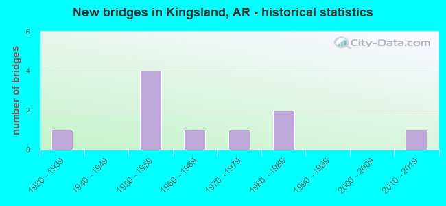
- New bridges - historical statistics
- 11930-1939
- 41950-1959
- 11960-1969
- 11970-1979
- 21980-1989
- 12010-2019


- Bridge Condition - Deck
- 12.5%Very good
- 25.0%Good
- 50.0%Satisfactory
- 12.5%Fair

- Bridge Condition - Superstructure
- 25.0%Good
- 50.0%Satisfactory
- 25.0%Fair

- Bridge Condition - Substructure
- 12.5%Very good
- 25.0%Good
- 62.5%Satisfactory

- Bridge Condition - Channel
- 20.0%Very good
- 30.0%Good
- 40.0%Satisfactory
- 10.0%Fair
Find on map >> Show street view
Structure Number: 301, Location: 5.67 MI SW OFJCT SH35 (Lat: 33.886578, Lng: -92.245328), Route carried "on" structure: US 79, Year Built: 1956, Status: Open, Structure Length: 15.12m (49.61ft), Average Daily Traffic: 2,750 (year 2018), Truck Traffic: 20%, Average Future Daily Traffic: 3,535 (year 2028), Design Load: H 20, Features Intersected: SALINE RELIEF
Minimum Vertical Clearance: 30+ m (98+ ft), Kilometerpoint: 11.137, Lanes on structure: 2, Base Highway Network: Yes, Owner: State Highway Agency, Approaching Roadway Width: 13.4m (44.0ft), Material/Design: Steel, Design/Construction: Stringer/Multi-beam, Number Of Spans In Main Unit: 13, Length of Maximum Span: 11.6m (38.1ft), Curb or Sidewalk Widths: Left: 0.5m (1.6ft), Right: 0.5m (1.6ft), Curb-To-Curb Width: 7.9m (25.9ft), Out-to-Out Width: 9.6m (31.5ft)
Condition: Deck: Satisfactory, Superstructure: Satisfactory, Substructure: Good, Channel: Satisfactory, Operating Rating: 49.0 metric tons, Method Used To Determine Operating Rating: Load Factor (LF), Inventory Rating: 29.9 metric tons, Method Used To Determine Inventory Rating: Load Factor (LF), Structural Evaluation: Equal to present minimum criteria, Deck Geometry: High priority of corrective action, Waterway Adequacy: Equal to present desirable criteria, Approach Roadway Alignment: Equal to present desirable criteria, Length Of Structure Improvement: 16.31m (53.51ft), Designated Inspection Frequency: Every 24 months, Critical Feature Inspection Frequency: Every 24 months, Inspection Date: July 2020, Roadway Improvement Cost: $235,000, Total Project Cost: $1,382,000, Deck Structure Type: Concrete Cast-file-Place, Wearing Surface/Protective System: Wearing Surface: Monolithic Concrete
Find on map >> Show street view
Structure Number: 3011, Location: 4.89 MI S JCT SH 35 (Lat: 33.894431, Lng: -92.235589), Route carried "on" structure: US 79, Year Built: 1956, Status: Open, Structure Length: 61.36m (201.31ft), Average Daily Traffic: 2,700 (year 2018), Truck Traffic: 20%, Average Future Daily Traffic: 3,535 (year 2028), Design Load: H 20, Features Intersected: SALINE RIVER
Minimum Vertical Clearance: 30+ m (98+ ft), Kilometerpoint: 12.392, Lanes on structure: 2, Base Highway Network: Yes, Owner: State Highway Agency, Approaching Roadway Width: 8.8m (28.9ft), Material/Design: Steel, Design/Construction: Stringer/Multi-beam, Number Of Spans In Main Unit: 49, Length of Maximum Span: 25.9m (85.0ft), Curb or Sidewalk Widths: Left: 0.5m (1.6ft), Right: 0.5m (1.6ft), Curb-To-Curb Width: 7.9m (25.9ft), Out-to-Out Width: 9.6m (31.5ft)
Condition: Deck: Fair, Superstructure: Fair, Substructure: Satisfactory, Channel: Good, Operating Rating: 37.2 metric tons, Method Used To Determine Operating Rating: Load Factor (LF), Inventory Rating: 22.7 metric tons, Method Used To Determine Inventory Rating: Load Factor (LF), Structural Evaluation: Somewhat better than minimum adequacy, Deck Geometry: High priority of corrective action, Waterway Adequacy: Equal to present desirable criteria, Approach Roadway Alignment: Equal to present desirable criteria, Length Of Structure Improvement: 62.06m (203.61ft), Designated Inspection Frequency: Every 24 months, Critical Feature Inspection Frequency: Every 24 months, Inspection Date: August 2021, Roadway Improvement Cost: $235,000, Total Project Cost: $4,263,000, Deck Structure Type: Concrete Cast-file-Place, Wearing Surface/Protective System: Wearing Surface: Monolithic Concrete
Find on map >> Show street view
Structure Number: 18597, Location: 3.76 MI SO OF US 79 (Lat: 33.855050, Lng: -92.222981), Route carried "on" structure: County highway 40, Year Built: 1985, Status: Open, Structure Length: 1.86m (6.10ft), Average Daily Traffic: 146 (year 2018), Truck Traffic: 2%, Average Future Daily Traffic: 170 (year 2038), Features Intersected: COTTONMOUTH CREEK
Minimum Vertical Clearance: 30+ m (98+ ft), Kilometerpoint: 6.050, Lanes on structure: 2, Owner: County Highway Agency, Approaching Roadway Width: 6.1m (20.0ft), Material/Design: Steel, Design/Construction: Orthotropic, Number Of Spans In Main Unit: 1, Length of Maximum Span: 17.4m (57.1ft), Curb-To-Curb Width: 5.9m (19.4ft), Out-to-Out Width: 5.9m (19.4ft)
Condition: Deck: Satisfactory, Superstructure: Satisfactory, Substructure: Satisfactory, Channel: Satisfactory, Operating Rating: 10.9 metric tons, Method Used To Determine Operating Rating: Load Factor (LF), Inventory Rating: 6.4 metric tons, Method Used To Determine Inventory Rating: Load Factor (LF), Structural Evaluation: High priority of corrective action, Deck Geometry: High priority of corrective action, Waterway Adequacy: Equal to present minimum criteria, Approach Roadway Alignment: Equal to present minimum criteria, Bridge Posting: Required (Relationship of Operating Rating to Maximum Legal Load: 30.0 - 39.9% below), Length Of Structure Improvement: 1.86m (6.10ft), Designated Inspection Frequency: Every 24 months, Critical Feature Inspection Frequency: Every 24 months, Inspection Date: July 2021, Critical Feature Inspection Date: July 2021, Total Project Cost: $52,000, Deck Structure Type: Steel plate, Wearing Surface/Protective System: Wearing Surface: Other
Find on map >> Show street view
Structure Number: 20182, Location: 0.37 MI N JCT US 79 (Lat: 33.878700, Lng: -92.266711), Route carried "on" structure: County highway 46, Year Built: 1983, Status: Posted for load, Structure Length: 1.04m (3.41ft), Average Daily Traffic: 53 (year 2018), Truck Traffic: 1%, Average Future Daily Traffic: 132 (year 2007), Design Load: H 15, Features Intersected: PANTHER CREEK
Minimum Vertical Clearance: 30+ m (98+ ft), Kilometerpoint: 0.595, Lanes on structure: 2, Owner: County Highway Agency, Approaching Roadway Width: 5.2m (17.1ft), Material/Design: Steel, Design/Construction: Orthotropic, Number Of Spans In Main Unit: 1, Length of Maximum Span: 8.5m (27.9ft), Curb-To-Curb Width: 6.1m (20.0ft), Out-to-Out Width: 6.1m (20.0ft)
Condition: Deck: Good, Superstructure: Satisfactory, Substructure: Satisfactory, Channel: Fair, Operating Rating: 16.3 metric tons, Method Used To Determine Operating Rating: Load Factor (LF), Inventory Rating: 10.0 metric tons, Method Used To Determine Inventory Rating: Load Factor (LF), Structural Evaluation: High priority of corrective action, Deck Geometry: Somewhat better than minimum adequacy, Waterway Adequacy: Equal to present minimum criteria, Approach Roadway Alignment: Somewhat better than minimum adequacy, Bridge Posting: Required (Relationship of Operating Rating to Maximum Legal Load: > 39.9% below), Length Of Structure Improvement: 1.04m (3.41ft), Designated Inspection Frequency: Every 24 months, Critical Feature Inspection Frequency: Every 24 months, Inspection Date: July 2021, Critical Feature Inspection Date: July 2021, Total Project Cost: $29,000, Deck Structure Type: Steel plate, Wearing Surface/Protective System: Wearing Surface: Gravel
Find on map >> Show street view
Structure Number: 24, Location: 3.36 M W Jct CR 17 (Lat: 34.504028, Lng: -93.795828), Route carried "on" structure: County highway 12, Year Built: 2017, Status: Open, Structure Length: 1.22m (4.00ft), Average Daily Traffic: 120 (year 2018), Truck Traffic: 1%, Average Future Daily Traffic: 130 (year 2037), Features Intersected: Dry Fork Creek, Facility Carried by Structure: Murphy Rd
Minimum Vertical Clearance: 30+ m (98+ ft), Kilometerpoint: 5.406, Lanes on structure: 2, Owner: County Highway Agency, Approaching Roadway Width: 6.7m (22.0ft), Skew: 2 degrees, Material/Design: Steel, Design/Construction: Stringer/Multi-beam, Number Of Spans In Main Unit: 1, Length of Maximum Span: 10.9m (35.8ft), Curb-To-Curb Width: 6.7m (22.0ft), Out-to-Out Width: 6.7m (22.0ft)
Condition: Deck: Very good, Superstructure: Good, Substructure: Very good, Channel: Good, Operating Rating: 54.4 metric tons, Method Used To Determine Operating Rating: Load Factor (LF), Inventory Rating: 32.7 metric tons, Method Used To Determine Inventory Rating: Load Factor (LF), Structural Evaluation: Better than present minimum criteria, Deck Geometry: Meets minimum limits, Waterway Adequacy: Better than present minimum criteria, Approach Roadway Alignment: Somewhat better than minimum adequacy, Designated Inspection Frequency: Every 24 months, Critical Feature Inspection Frequency: Every 24 months, Inspection Date: November 2020, Deck Structure Type: Concrete Cast-file-Place
Find on map >> Show street view
Structure Number: M1455, Location: 0.8 MI NE DALLAS CO L (Lat: 33.859258, Lng: -92.341908), Route carried "on" structure: US 79, Year Built: 1931, Status: Open, Structure Length: 0.67m (2.20ft), Average Daily Traffic: 2,786 (year 2018), Truck Traffic: 1%, Average Future Daily Traffic: 4,189 (year 2028), Design Load: H 15, Features Intersected: CREEK
Minimum Vertical Clearance: 30+ m (98+ ft), Kilometerpoint: 1.175, Lanes on structure: 2, Base Highway Network: Yes, Owner: State Highway Agency, Approaching Roadway Width: 13.4m (44.0ft), Material/Design: Concrete, Design/Construction: Culvert, Number Of Spans In Main Unit: 2, Length of Maximum Span: 3.0m (9.8ft), Out-to-Out Width: 15.2m (49.9ft)
Condition: Channel: Very good, Culverts: Good, Operating Rating: 29.9 metric tons, Method Used To Determine Operating Rating: Load Factor (LF), Inventory Rating: 18.1 metric tons, Method Used To Determine Inventory Rating: Load Factor (LF), Structural Evaluation: Somewhat better than minimum adequacy, Waterway Adequacy: Equal to present desirable criteria, Approach Roadway Alignment: Equal to present desirable criteria, Designated Inspection Frequency: Every 24 months, Critical Feature Inspection Frequency: Every 24 months, Inspection Date: July 2020
Find on map >> Show street view
Structure Number: M1456, Location: 0.98 MI NE DALLAS CO L (Lat: 33.860808, Lng: -92.338589), Route carried "on" structure: US 79, Year Built: 1954, Status: Open, Structure Length: 0.70m (2.30ft), Average Daily Traffic: 2,786 (year 2018), Truck Traffic: 1%, Average Future Daily Traffic: 4,189 (year 2028), Design Load: H 15, Features Intersected: CREEK
Minimum Vertical Clearance: 30+ m (98+ ft), Kilometerpoint: 1.465, Lanes on structure: 2, Base Highway Network: Yes, Owner: State Highway Agency, Approaching Roadway Width: 13.4m (44.0ft), Skew: 4 degrees, Material/Design: Concrete, Design/Construction: Culvert, Number Of Spans In Main Unit: 2, Length of Maximum Span: 3.0m (9.8ft), Curb-To-Curb Width: 15.5m (50.9ft), Out-to-Out Width: 15.5m (50.9ft)
Condition: Channel: Satisfactory, Culverts: Good, Operating Rating: 29.9 metric tons, Method Used To Determine Operating Rating: Load Factor (LF), Inventory Rating: 18.1 metric tons, Method Used To Determine Inventory Rating: Load Factor (LF), Structural Evaluation: Somewhat better than minimum adequacy, Deck Geometry: Superior to present desirable criteria, Waterway Adequacy: Equal to present minimum criteria, Approach Roadway Alignment: Equal to present desirable criteria, Designated Inspection Frequency: Every 24 months, Critical Feature Inspection Frequency: Every 24 months, Inspection Date: July 2020
Find on map >> Show street view
Structure Number: M1457, Location: 0.8 MI NE OF KINGSLAND (Lat: 33.868469, Lng: -92.275681), Route carried "on" structure: US 79, Year Built: 1958, Status: Open, Structure Length: 2.29m (7.51ft), Average Daily Traffic: 2,750 (year 2018), Truck Traffic: 1%, Average Future Daily Traffic: 3,535 (year 2028), Features Intersected: PANTHER CREEK
Minimum Vertical Clearance: 30+ m (98+ ft), Kilometerpoint: 7.693, Lanes on structure: 2, Base Highway Network: Yes, Owner: State Highway Agency, Approaching Roadway Width: 13.4m (44.0ft), Material/Design: Concrete, Design/Construction: Slab, Number Of Spans In Main Unit: 3, Length of Maximum Span: 7.6m (24.9ft), Curb or Sidewalk Widths: Left: 0.5m (1.6ft), Right: 0.5m (1.6ft), Curb-To-Curb Width: 8.5m (27.9ft), Out-to-Out Width: 9.6m (31.5ft)
Condition: Deck: Satisfactory, Superstructure: Satisfactory, Substructure: Satisfactory, Channel: Good, Operating Rating: 47.2 metric tons, Method Used To Determine Operating Rating: Load Factor (LF), Inventory Rating: 28.1 metric tons, Method Used To Determine Inventory Rating: Load Factor (LF), Structural Evaluation: Equal to present minimum criteria, Deck Geometry: Meets minimum limits, Waterway Adequacy: Equal to present minimum criteria, Approach Roadway Alignment: Equal to present desirable criteria, Designated Inspection Frequency: Every 24 months, Critical Feature Inspection Frequency: Every 24 months, Inspection Date: December 2021, Deck Structure Type: Concrete Cast-file-Place, Wearing Surface/Protective System: Wearing Surface: Monolithic Concrete
Find on map >> Show street view
Structure Number: M3156, Location: 3.27 MI SE JCT SH 97 (Lat: 33.830481, Lng: -92.249311), Route carried "on" structure: State highway 189, Year Built: 1967, Status: Open, Structure Length: 1.19m (3.90ft), Average Daily Traffic: 240 (year 2018), Truck Traffic: 1%, Average Future Daily Traffic: 406 (year 2028), Design Load: H 15, Features Intersected: CREEK
Minimum Vertical Clearance: 30+ m (98+ ft), Kilometerpoint: 5.214, Lanes on structure: 2, Owner: State Highway Agency, Approaching Roadway Width: 6.7m (22.0ft), Material/Design: Concrete, Design/Construction: Channel Beam, Number Of Spans In Main Unit: 2, Length of Maximum Span: 5.8m (19.0ft), Curb or Sidewalk Widths: Left: 0.2m (0.7ft), Right: 0.2m (0.7ft), Curb-To-Curb Width: 7.3m (24.0ft), Out-to-Out Width: 7.6m (24.9ft)
Condition: Deck: Good, Superstructure: Good, Substructure: Good, Channel: Very good, Operating Rating: 43.5 metric tons, Method Used To Determine Operating Rating: Load Factor (LF), Inventory Rating: 24.5 metric tons, Method Used To Determine Inventory Rating: Load Factor (LF), Structural Evaluation: Equal to present minimum criteria, Deck Geometry: Somewhat better than minimum adequacy, Waterway Adequacy: Better than present minimum criteria, Approach Roadway Alignment: Equal to present desirable criteria, Designated Inspection Frequency: Every 24 months, Critical Feature Inspection Frequency: Every 24 months, Inspection Date: June 2021, Deck Structure Type: Concrete Precast Panels, Wearing Surface/Protective System: Wearing Surface: Monolithic Concrete
Find on map >> Show street view
Structure Number: M3561, Location: 0.86 MI SW JCT US 79 (Lat: 33.855889, Lng: -92.293631), Route carried "on" structure: State highway 97, Year Built: 1971, Status: Open, Structure Length: 2.35m (7.71ft), Average Daily Traffic: 935 (year 2018), Truck Traffic: 1%, Average Future Daily Traffic: 1,440 (year 2028), Design Load: H 15, Features Intersected: CREEK
Minimum Vertical Clearance: 30+ m (98+ ft), Kilometerpoint: 9.093, Lanes on structure: 2, Owner: State Highway Agency, Approaching Roadway Width: 7.9m (25.9ft), Material/Design: Concrete, Design/Construction: Channel Beam, Number Of Spans In Main Unit: 4, Length of Maximum Span: 5.8m (19.0ft), Curb or Sidewalk Widths: Left: 0.2m (0.7ft), Right: 0.2m (0.7ft), Curb-To-Curb Width: 8.0m (26.2ft), Out-to-Out Width: 8.6m (28.2ft)
Condition: Deck: Satisfactory, Superstructure: Fair, Substructure: Satisfactory, Channel: Satisfactory, Operating Rating: 54.4 metric tons, Method Used To Determine Operating Rating: Load Factor (LF), Inventory Rating: 32.7 metric tons, Method Used To Determine Inventory Rating: Load Factor (LF), Structural Evaluation: Somewhat better than minimum adequacy, Deck Geometry: Somewhat better than minimum adequacy, Waterway Adequacy: Equal to present desirable criteria, Approach Roadway Alignment: Equal to present desirable criteria, Designated Inspection Frequency: Every 24 months, Critical Feature Inspection Frequency: Every 24 months, Inspection Date: November 2021, Deck Structure Type: Concrete Precast Panels, Wearing Surface/Protective System: Wearing Surface: Monolithic Concrete