Bridge Statistics for Klemme, Iowa (IA)
Condition, Traffic, Stress, Structural Evaluation, Project Costs
- National Bridge Inventory (NBI) Statistics
- 11Number of bridges
- 115ft / 34.6mTotal length
- 4,755Total average daily traffic
- 1,129Total average daily truck traffic
- 4,755Total future (year 2039) average daily traffic
- National Bridge Inventory (NBI) Registered Bridges for Klemme
- No street view available for this location
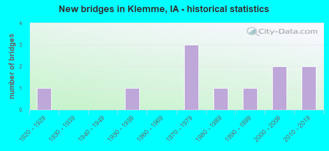
- New bridges - historical statistics
- 11920-1929
- 11950-1959
- 31970-1979
- 11980-1989
- 11990-1999
- 22000-2009
- 22010-2019

- Bridge Condition - Deck
- 30.0%Very good
- 10.0%Good
- 40.0%Satisfactory
- 10.0%Fair
- 10.0%Poor

- Bridge Condition - Superstructure
- 40.0%Very good
- 20.0%Good
- 30.0%Satisfactory
- 10.0%Fair

- Bridge Condition - Substructure
- 30.0%Very good
- 50.0%Good
- 20.0%Serious

- Bridge Condition - Channel
- 45.5%Very good
- 9.1%Good
- 45.5%Satisfactory
Find on map >> Show street view
Structure Number: 26851, Location: 0.6 mi. S of SR B-55 (Lat: 43.000028, Lng: -93.616367), Route carried "on" structure: US 69, Year Built: 2015, Status: Open, Structure Length: 5.22m (17.13ft), Average Daily Traffic: 1,490 (year 2020), Truck Traffic: 28%, Average Future Daily Traffic: 1,490 (year 2041), Design Load: HL 93, Features Intersected: E BRANCH IOWA RIVER
Minimum Vertical Clearance: 30+ m (98+ ft), Kilometerpoint: 299.526, Lanes on structure: 2, Base Highway Network: Yes, Owner: State Highway Agency, Approaching Roadway Width: 12.2m (40.0ft), Skew: 2 degrees, Material/Design: Prestressed concrete, Design/Construction: Stringer/Multi-beam, Number Of Spans In Main Unit: 3, Length of Maximum Span: 16.9m (55.4ft), Curb-To-Curb Width: 12.2m (40.0ft), Out-to-Out Width: 13.2m (43.3ft)
Condition: Deck: Good, Superstructure: Very good, Substructure: Very good, Channel: Very good, Operating Rating: 42.1 metric tons, Method Used To Determine Operating Rating: Assigned ratings based on Load and Resistance Factor Design (LRFD) reported by rating factor (RF) using HL93 loadings, Inventory Rating: 32.4 metric tons, Method Used To Determine Inventory Rating: Assigned ratings based on Load and Resistance Factor Design (LRFD) reported by rating factor (RF) using HL93 loadings, Structural Evaluation: Equal to present desirable criteria, Deck Geometry: Better than present minimum criteria, Waterway Adequacy: Superior to present desirable criteria, Approach Roadway Alignment: Equal to present desirable criteria, Designated Inspection Frequency: Every 24 months, Inspection Date: December 2021, Deck Structure Type: Concrete Cast-file-Place, Wearing Surface/Protective System: Wearing Surface: Monolithic Concrete, Deck Protection: Epoxy Coated Reinforcing
Find on map >> Show street view
Structure Number: 2686, Location: 0.4 mi. S of Jct. SR B55 (Lat: 43.003014, Lng: -93.616358), Route carried "on" structure: US 69, Year Built: 1922, Year Reconstructed: 1960, Status: Open, Structure Length: 0.64m (2.10ft), Average Daily Traffic: 1,490 (year 2020), Truck Traffic: 28%, Average Future Daily Traffic: 1,490 (year 2040), Design Load: H 20, Features Intersected: IOWA RIVER OVERFLOW
Minimum Vertical Clearance: 30+ m (98+ ft), Kilometerpoint: 299.858, Lanes on structure: 2, Base Highway Network: Yes, Owner: State Highway Agency, Approaching Roadway Width: 11.0m (36.1ft), Material/Design: Concrete, Design/Construction: Slab, Number Of Spans In Main Unit: 1, Length of Maximum Span: 5.8m (19.0ft), Curb-To-Curb Width: 12.9m (42.3ft), Out-to-Out Width: 14.0m (45.9ft)
Condition: Deck: Satisfactory, Superstructure: Satisfactory, Substructure: Good, Channel: Satisfactory, Operating Rating: 48.1 metric tons, Method Used To Determine Operating Rating: Load Factor (LF), Inventory Rating: 29.0 metric tons, Method Used To Determine Inventory Rating: Load Factor (LF), Structural Evaluation: Equal to present minimum criteria, Deck Geometry: Better than present minimum criteria, Waterway Adequacy: Somewhat better than minimum adequacy, Approach Roadway Alignment: Equal to present desirable criteria, Designated Inspection Frequency: Every 24 months, Inspection Date: August 2020, Deck Structure Type: Concrete Cast-file-Place, Wearing Surface/Protective System: Wearing Surface: Bituminous
Find on map >> Show street view
Structure Number: 172571, Location: 094230701 (Lat: 42.981100, Lng: -93.597247), Route carried "on" structure: County highway , Year Built: 2005, Status: Open, Structure Length: 4.21m (13.81ft), Average Daily Traffic: 40 (year 2015), Average Future Daily Traffic: 40 (year 2039), Design Load: HS 20, Features Intersected: EAST IOWA RIVER, Facility Carried by Structure: 1995 150TH ST
Minimum Vertical Clearance: 30+ m (98+ ft), Kilometerpoint: 30.520, Lanes on structure: 2, Owner: County Highway Agency, Approaching Roadway Width: 7.3m (24.0ft), Material/Design: Concrete continuous, Design/Construction: Slab, Number Of Spans In Main Unit: 3, Length of Maximum Span: 15.9m (52.2ft), Curb-To-Curb Width: 9.3m (30.5ft), Out-to-Out Width: 10.1m (33.1ft)
Condition: Deck: Very good, Superstructure: Very good, Substructure: Very good, Channel: Very good, Operating Rating: 82.9 metric tons, Method Used To Determine Operating Rating: Load Factor (LF), Inventory Rating: 49.7 metric tons, Method Used To Determine Inventory Rating: Load Factor (LF), Structural Evaluation: Equal to present desirable criteria, Deck Geometry: Better than present minimum criteria, Waterway Adequacy: Equal to present desirable criteria, Approach Roadway Alignment: Better than present minimum criteria, Length Of Structure Improvement: 13.50m (44.29ft), Designated Inspection Frequency: Every 48 months, Inspection Date: April 2019, Bridge Improvement Cost: $15,000, Roadway Improvement Cost: $2,000, Deck Structure Type: Concrete Cast-file-Place, Wearing Surface/Protective System: Wearing Surface: Monolithic Concrete
Find on map >> Show street view
Structure Number: 172581, Location: 094230802 (Lat: 42.978217, Lng: -93.596642), Route carried "on" structure: County highway , Year Built: 2005, Status: Open, Structure Length: 4.66m (15.29ft), Average Daily Traffic: 45 (year 2015), Average Future Daily Traffic: 45 (year 2039), Design Load: HS 20, Features Intersected: EAST IOWA RIVER, Facility Carried by Structure: 1480 TAFT AVE
Minimum Vertical Clearance: 30+ m (98+ ft), Kilometerpoint: 3.711, Lanes on structure: 2, Owner: County Highway Agency, Approaching Roadway Width: 7.9m (25.9ft), Material/Design: Concrete continuous, Design/Construction: Slab, Number Of Spans In Main Unit: 3, Length of Maximum Span: 17.7m (58.1ft), Curb-To-Curb Width: 7.3m (24.0ft), Out-to-Out Width: 8.1m (26.6ft)
Condition: Deck: Very good, Superstructure: Very good, Substructure: Very good, Channel: Very good, Operating Rating: 89.8 metric tons, Method Used To Determine Operating Rating: Load Factor (LF), Inventory Rating: 53.8 metric tons, Method Used To Determine Inventory Rating: Load Factor (LF), Structural Evaluation: Equal to present desirable criteria, Deck Geometry: Equal to present minimum criteria, Waterway Adequacy: Equal to present desirable criteria, Approach Roadway Alignment: Equal to present desirable criteria, Length Of Structure Improvement: 15.00m (49.21ft), Designated Inspection Frequency: Every 48 months, Inspection Date: April 2019, Bridge Improvement Cost: $15,000, Roadway Improvement Cost: $2,000, Deck Structure Type: Concrete Cast-file-Place, Wearing Surface/Protective System: Wearing Surface: Monolithic Concrete
Find on map >> Show street view
Structure Number: 173181, Location: 095233201 (Lat: 43.009678, Lng: -93.590389), Route carried "on" structure: County highway , Year Built: 1975, Status: Open, Structure Length: 1.65m (5.41ft), Average Daily Traffic: 690 (year 2019), Truck Traffic: 25%, Average Future Daily Traffic: 690 (year 2040), Design Load: H 20, Features Intersected: DRAINAGE DITCH #9, Facility Carried by Structure: FM 2030 170TH
Minimum Vertical Clearance: 30+ m (98+ ft), Kilometerpoint: 27.037, Lanes on structure: 2, Owner: County Highway Agency, Approaching Roadway Width: 9.8m (32.2ft), Material/Design: Prestressed concrete, Design/Construction: Stringer/Multi-beam, Number Of Spans In Main Unit: 1, Length of Maximum Span: 15.5m (50.9ft), Curb-To-Curb Width: 9.1m (29.9ft), Out-to-Out Width: 9.8m (32.2ft)
Condition: Deck: Satisfactory, Superstructure: Good, Substructure: Good, Channel: Good, Operating Rating: 71.7 metric tons, Method Used To Determine Operating Rating: Allowable Stress (AS), Inventory Rating: 36.9 metric tons, Method Used To Determine Inventory Rating: Allowable Stress (AS), Structural Evaluation: Better than present minimum criteria, Deck Geometry: Equal to present minimum criteria, Waterway Adequacy: Equal to present minimum criteria, Approach Roadway Alignment: Better than present minimum criteria, Length Of Structure Improvement: 5.40m (17.72ft), Designated Inspection Frequency: Every 48 months, Inspection Date: April 2020, Bridge Improvement Cost: $15,000, Roadway Improvement Cost: $2,000, Deck Structure Type: Concrete Cast-file-Place, Wearing Surface/Protective System: Wearing Surface: Monolithic Concrete
Find on map >> Show street view
Structure Number: 173191, Location: 095233212 (Lat: 42.999447, Lng: -93.596533), Route carried "on" structure: County highway , Year Built: 2010, Status: Open, Structure Length: 0.76m (2.49ft), Average Daily Traffic: 230 (year 2015), Average Future Daily Traffic: 230 (year 2040), Design Load: HS 20, Features Intersected: DRAINAGE DITCH 9, Facility Carried by Structure: LOC 1620 TAFT
Minimum Vertical Clearance: 30+ m (98+ ft), Kilometerpoint: 6.069, Lanes on structure: 2, Owner: County Highway Agency, Approaching Roadway Width: 9.1m (29.9ft), Material/Design: Concrete continuous, Design/Construction: Culvert, Number Of Spans In Main Unit: 2, Length of Maximum Span: 3.7m (12.1ft)
Condition: Channel: Very good, Culverts: Very good, Operating Rating: 44.1 metric tons, Method Used To Determine Operating Rating: Assigned rating based on Load Factor Design (LFD) reported in metric tons, Inventory Rating: 32.7 metric tons, Method Used To Determine Inventory Rating: Assigned rating based on Load Factor Design (LFD) reported in metric tons, Structural Evaluation: Equal to present desirable criteria, Waterway Adequacy: Equal to present desirable criteria, Approach Roadway Alignment: Better than present minimum criteria, Designated Inspection Frequency: Every 48 months, Inspection Date: April 2020, Deck Structure Type: Concrete Precast Panels, Wearing Surface/Protective System: Wearing Surface: Gravel
Find on map >> Show street view
Structure Number: 173301, Location: 095242301 (Lat: 43.038536, Lng: -93.642633), Route carried "on" structure: County highway , Year Built: 1993, Status: Open, Structure Length: 4.39m (14.40ft), Average Daily Traffic: 50 (year 2015), Average Future Daily Traffic: 50 (year 2040), Design Load: HS 20, Features Intersected: EAST BRANCH IA RIVER, Facility Carried by Structure: 1770 190TH ST
Minimum Vertical Clearance: 30+ m (98+ ft), Kilometerpoint: 26.749, Lanes on structure: 2, Owner: County Highway Agency, Approaching Roadway Width: 7.9m (25.9ft), Skew: 3 degrees, Material/Design: Concrete continuous, Design/Construction: Slab, Number Of Spans In Main Unit: 3, Length of Maximum Span: 16.5m (54.1ft), Curb-To-Curb Width: 7.5m (24.6ft), Out-to-Out Width: 8.3m (27.2ft)
Condition: Deck: Very good, Superstructure: Very good, Substructure: Good, Channel: Very good, Inventory Rating: 56.5 metric tons, Method Used To Determine Inventory Rating: Load Factor (LF), Structural Evaluation: Better than present minimum criteria, Deck Geometry: Equal to present minimum criteria, Waterway Adequacy: Equal to present desirable criteria, Approach Roadway Alignment: Equal to present desirable criteria, Length Of Structure Improvement: 14.40m (47.24ft), Designated Inspection Frequency: Every 48 months, Inspection Date: April 2020, Bridge Improvement Cost: $15,000, Roadway Improvement Cost: $2,000, Deck Structure Type: Concrete Cast-file-Place, Wearing Surface/Protective System: Wearing Surface: Monolithic Concrete
Find on map >> Show street view
Structure Number: 17331, Location: 095242302 (Lat: 43.030100, Lng: -93.655611), Route carried "on" structure: County highway , Year Built: 1970, Status: Posted for load, Structure Length: 0.64m (2.10ft), Average Daily Traffic: 20 (year 2015), Average Future Daily Traffic: 20 (year 2041), Features Intersected: DD #6, Facility Carried by Structure: 1840 QUAIL AVE
Minimum Vertical Clearance: 30+ m (98+ ft), Kilometerpoint: 11.906, Lanes on structure: 2, Owner: County Highway Agency, Approaching Roadway Width: 7.3m (24.0ft), Material/Design: Wood or Timber, Design/Construction: Stringer/Multi-beam, Number Of Spans In Main Unit: 1, Length of Maximum Span: 6.1m (20.0ft), Curb-To-Curb Width: 6.1m (20.0ft), Out-to-Out Width: 6.1m (20.0ft)
Condition: Deck: Fair, Superstructure: Fair, Substructure: Serious, Channel: Satisfactory, Operating Rating: 21.5 metric tons, Method Used To Determine Operating Rating: Allowable Stress (AS), Inventory Rating: 17.1 metric tons, Method Used To Determine Inventory Rating: Allowable Stress (AS), Structural Evaluation: High priority of corrective action, Deck Geometry: Somewhat better than minimum adequacy, Waterway Adequacy: Equal to present minimum criteria, Approach Roadway Alignment: Better than present minimum criteria, Bridge Posting: Required (Relationship of Operating Rating to Maximum Legal Load: 20.0 - 29.9% below), Length Of Structure Improvement: 4.00m (13.12ft), Designated Inspection Frequency: Every 12 months, Inspection Date: March 2021, Bridge Improvement Cost: $96,000, Roadway Improvement Cost: $10,000, Deck Structure Type: Wood or Timber, Wearing Surface/Protective System: Wearing Surface: Gravel
Find on map >> Show street view
Structure Number: 173321, Location: 095242502 (Lat: 43.015219, Lng: -93.635933), Route carried "on" structure: County highway , Year Built: 1985, Status: Open, Structure Length: 4.42m (14.50ft), Average Daily Traffic: 35 (year 2015), Average Future Daily Traffic: 35 (year 2040), Design Load: H 15, Features Intersected: EAST BRANCH IA RIVER, Facility Carried by Structure: 1740 RAKE AVE
Minimum Vertical Clearance: 30+ m (98+ ft), Kilometerpoint: 10.673, Lanes on structure: 2, Owner: County Highway Agency, Approaching Roadway Width: 7.3m (24.0ft), Material/Design: Concrete continuous, Design/Construction: Slab, Number Of Spans In Main Unit: 3, Length of Maximum Span: 16.5m (54.1ft), Curb-To-Curb Width: 7.3m (24.0ft), Out-to-Out Width: 7.9m (25.9ft)
Condition: Deck: Satisfactory, Superstructure: Satisfactory, Substructure: Good, Channel: Satisfactory, Operating Rating: 37.6 metric tons, Method Used To Determine Operating Rating: Load Factor (LF), Inventory Rating: 22.6 metric tons, Method Used To Determine Inventory Rating: Load Factor (LF), Structural Evaluation: Equal to present minimum criteria, Deck Geometry: Equal to present minimum criteria, Waterway Adequacy: Better than present minimum criteria, Approach Roadway Alignment: Better than present minimum criteria, Length Of Structure Improvement: 14.20m (46.59ft), Designated Inspection Frequency: Every 24 months, Inspection Date: March 2020, Bridge Improvement Cost: $15,000, Roadway Improvement Cost: $2,000, Deck Structure Type: Concrete Cast-file-Place, Wearing Surface/Protective System: Wearing Surface: Monolithic Concrete
Find on map >> Show street view
Structure Number: 17333, Location: 095242601 (Lat: 43.024117, Lng: -93.644400), Route carried "on" structure: County highway , Year Built: 1959, Status: Posted for load, Structure Length: 3.69m (12.11ft), Average Daily Traffic: 15 (year 2015), Average Future Daily Traffic: 15 (year 2041), Design Load: H 15, Features Intersected: EAST IOWA RIVER, Facility Carried by Structure: 1760 180TH ST
Minimum Vertical Clearance: 30+ m (98+ ft), Kilometerpoint: 23.616, Lanes on structure: 2, Owner: County Highway Agency, Approaching Roadway Width: 7.9m (25.9ft), Material/Design: Prestressed concrete, Design/Construction: Stringer/Multi-beam, Number Of Spans In Main Unit: 3, Length of Maximum Span: 17.4m (57.1ft), Curb-To-Curb Width: 6.1m (20.0ft), Out-to-Out Width: 6.6m (21.7ft)
Condition: Deck: Poor, Superstructure: Satisfactory, Substructure: Serious, Channel: Satisfactory, Operating Rating: 3.6 metric tons, Method Used To Determine Operating Rating: Allowable Stress (AS), Structural Evaluation: High priority of replacement, Deck Geometry: Somewhat better than minimum adequacy, Waterway Adequacy: Equal to present minimum criteria, Approach Roadway Alignment: Better than present minimum criteria, Bridge Posting: Required (Relationship of Operating Rating to Maximum Legal Load: > 39.9% below), Length Of Structure Improvement: 15.00m (49.21ft), Designated Inspection Frequency: Every 12 months, Inspection Date: March 2021, Bridge Improvement Cost: $342,000, Roadway Improvement Cost: $34,000, Deck Structure Type: Concrete Cast-file-Place, Wearing Surface/Protective System: Wearing Surface: Monolithic Concrete
Find on map >> Show street view
Structure Number: 173361, Location: 095243601 (Lat: 43.009253, Lng: -93.628117), Route carried "on" structure: County highway , Year Built: 1975, Status: Open, Structure Length: 4.33m (14.21ft), Average Daily Traffic: 650 (year 2019), Truck Traffic: 19%, Average Future Daily Traffic: 650 (year 2040), Design Load: H 20, Features Intersected: E BR IOWA RIVER, Facility Carried by Structure: 1840 170TH ST
Minimum Vertical Clearance: 30+ m (98+ ft), Kilometerpoint: 24.758, Lanes on structure: 2, Owner: County Highway Agency, Approaching Roadway Width: 10.4m (34.1ft), Skew: 2 degrees, Material/Design: Prestressed concrete, Design/Construction: Stringer/Multi-beam, Number Of Spans In Main Unit: 3, Length of Maximum Span: 15.9m (52.2ft), Curb-To-Curb Width: 9.1m (29.9ft), Out-to-Out Width: 9.8m (32.2ft)
Condition: Deck: Satisfactory, Superstructure: Good, Substructure: Good, Channel: Satisfactory, Operating Rating: 71.7 metric tons, Method Used To Determine Operating Rating: Allowable Stress (AS), Inventory Rating: 36.9 metric tons, Method Used To Determine Inventory Rating: Allowable Stress (AS), Structural Evaluation: Better than present minimum criteria, Deck Geometry: Equal to present minimum criteria, Waterway Adequacy: Equal to present minimum criteria, Approach Roadway Alignment: Better than present minimum criteria, Length Of Structure Improvement: 14.20m (46.59ft), Designated Inspection Frequency: Every 48 months, Inspection Date: April 2020, Bridge Improvement Cost: $15,000, Roadway Improvement Cost: $2,000, Deck Structure Type: Concrete Cast-file-Place, Wearing Surface/Protective System: Wearing Surface: Monolithic Concrete