Bridge Statistics for La Crosse, Indiana (IN)
Condition, Traffic, Stress, Structural Evaluation, Project Costs
- National Bridge Inventory (NBI) Statistics
- 16Number of bridges
- 121ft / 37.3mTotal length
- $1,420,000Total costs
- 16,132Total average daily traffic
- 1,686Total average daily truck traffic
- 23,836Total future (year 2030) average daily traffic
- National Bridge Inventory (NBI) Registered Bridges for La Crosse
- No street view available for this location
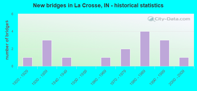
- New bridges - historical statistics
- 11920-1929
- 31930-1939
- 11940-1949
- 11960-1969
- 21970-1979
- 41980-1989
- 31990-1999
- 12000-2009

- Reconstructed bridges - Historical Statistics
- 21970-1979
- 21980-1989
- 01990-1999
- 02000-2009
- 12010-2019
- 12020-2022


- Bridge Condition - Deck
- 53.8%Good
- 7.7%Satisfactory
- 38.5%Fair

- Bridge Condition - Superstructure
- 42.9%Good
- 14.3%Satisfactory
- 35.7%Fair
- 7.1%Poor

- Bridge Condition - Substructure
- 35.7%Good
- 7.1%Satisfactory
- 50.0%Fair
- 7.1%Poor

- Bridge Condition - Channel
- 18.8%Very good
- 31.3%Good
- 37.5%Satisfactory
- 12.5%Fair
Find on map >> Show street view
Structure Number: 216, Location: 02.03 W US 421 (Lat: 41.318331, Lng: -86.931661), Route carried "on" structure: State highway 8, Year Built: 1994, Year Reconstructed: 2020, Status: Open, Structure Length: 2.41m (7.91ft), Average Daily Traffic: 2,707 (year 2016), Truck Traffic: 21%, Average Future Daily Traffic: 3,346 (year 2041), Design Load: HS 20, Features Intersected: GRASSMERE DITCH
Minimum Vertical Clearance: 30+ m (98+ ft), Kilometerpoint: 22.563, Lanes on structure: 2, Owner: State Highway Agency, Approaching Roadway Width: 10.1m (33.1ft), Material/Design: Concrete continuous, Design/Construction: Slab, Number Of Spans In Main Unit: 3, Length of Maximum Span: 9.3m (30.5ft), Curb-To-Curb Width: 10.2m (33.5ft), Out-to-Out Width: 11.1m (36.4ft)
Condition: Deck: Good, Superstructure: Good, Substructure: Good, Channel: Very good, Operating Rating: 39.9 metric tons, Method Used To Determine Operating Rating: Load and Resistance Factor Rating (LRFR) rating reported by rating factor(RF) method using HL-93 loadings, Inventory Rating: 30.8 metric tons, Method Used To Determine Inventory Rating: Load and Resistance Factor Rating (LRFR) rating reported by rating factor(RF) method using HL-93 loadings, Structural Evaluation: Better than present minimum criteria, Deck Geometry: Meets minimum limits, Waterway Adequacy: Equal to present desirable criteria, Approach Roadway Alignment: Equal to present desirable criteria, Designated Inspection Frequency: Every 24 months, Inspection Date: December 2020, Deck Structure Type: Concrete Cast-file-Place, Wearing Surface/Protective System: Wearing Surface: Latex Concrete, Deck Protection: Epoxy Coated Reinforcing
Find on map >> Show street view
Structure Number: 217, Location: 00.24 W US 421 (Lat: 41.317311, Lng: -86.896119), Route carried "on" structure: State highway 8, Year Built: 1933, Status: Open, Structure Length: 0.79m (2.59ft), Average Daily Traffic: 2,420 (year 2015), Truck Traffic: 5%, Average Future Daily Traffic: 3,970 (year 2030), Features Intersected: COOK DITCH
Minimum Vertical Clearance: 30+ m (98+ ft), Kilometerpoint: 2.881, Lanes on structure: 2, Owner: State Highway Agency, Approaching Roadway Width: 7.3m (24.0ft), Material/Design: Concrete, Design/Construction: Arch - Deck, Number Of Spans In Main Unit: 1, Length of Maximum Span: 7.3m (24.0ft), Curb-To-Curb Width: 9.8m (32.2ft), Out-to-Out Width: 10.7m (35.1ft)
Condition: Superstructure: Satisfactory, Substructure: Fair, Channel: Good, Operating Rating: 49.0 metric tons, Method Used To Determine Operating Rating: Field evaluation and documented engineering judgment, Inventory Rating: 29.4 metric tons, Method Used To Determine Inventory Rating: Field evaluation and documented engineering judgment, Structural Evaluation: Somewhat better than minimum adequacy, Deck Geometry: Meets minimum limits, Waterway Adequacy: Equal to present minimum criteria, Approach Roadway Alignment: Equal to present desirable criteria, Designated Inspection Frequency: Every 24 months, Inspection Date: December 2020
Find on map >> Show street view
Structure Number: 218, Location: 02.01 E US 421 (Lat: 41.317200, Lng: -86.852981), Route carried "on" structure: State highway 8, Year Built: 2003, Status: Open, Structure Length: 2.07m (6.79ft), Average Daily Traffic: 2,105 (year 2004), Truck Traffic: 10%, Average Future Daily Traffic: 3,495 (year 2030), Design Load: HS 20+Mod, Features Intersected: BESSLER DITCH
Minimum Vertical Clearance: 30+ m (98+ ft), Kilometerpoint: 29.065, Lanes on structure: 2, Owner: State Highway Agency, Approaching Roadway Width: 9.4m (30.8ft), Material/Design: Concrete continuous, Design/Construction: Slab, Number Of Spans In Main Unit: 3, Length of Maximum Span: 7.8m (25.6ft), Curb-To-Curb Width: 9.6m (31.5ft), Out-to-Out Width: 10.5m (34.4ft)
Condition: Deck: Good, Superstructure: Good, Substructure: Good, Channel: Very good, Operating Rating: 47.6 metric tons, Method Used To Determine Operating Rating: Load and Resistance Factor Rating (LRFR) rating reported by rating factor(RF) method using HL-93 loadings, Inventory Rating: 36.6 metric tons, Method Used To Determine Inventory Rating: Load and Resistance Factor Rating (LRFR) rating reported by rating factor(RF) method using HL-93 loadings, Structural Evaluation: Better than present minimum criteria, Deck Geometry: Meets minimum limits, Waterway Adequacy: Equal to present desirable criteria, Approach Roadway Alignment: Equal to present desirable criteria, Designated Inspection Frequency: Every 24 months, Inspection Date: December 2020, Deck Structure Type: Concrete Cast-file-Place, Wearing Surface/Protective System: Wearing Surface: Monolithic Concrete, Deck Protection: Epoxy Coated Reinforcing
Find on map >> Show street view
Structure Number: 219, Location: 02.24 E US 421 (Lat: 41.317169, Lng: -86.848481), Route carried "on" structure: State highway 8, Year Built: 1993, Year Reconstructed: 2015, Status: Open, Structure Length: 2.47m (8.10ft), Average Daily Traffic: 2,105 (year 2004), Truck Traffic: 10%, Average Future Daily Traffic: 3,495 (year 2030), Design Load: HS 20, Features Intersected: PITNER DITCH
Minimum Vertical Clearance: 30+ m (98+ ft), Kilometerpoint: 6.872, Lanes on structure: 2, Owner: State Highway Agency, Approaching Roadway Width: 7.3m (24.0ft), Skew: 1 degrees, Material/Design: Concrete continuous, Design/Construction: Slab, Number Of Spans In Main Unit: 3, Length of Maximum Span: 9.6m (31.5ft), Curb-To-Curb Width: 12.6m (41.3ft), Out-to-Out Width: 13.5m (44.3ft)
Condition: Deck: Good, Superstructure: Good, Substructure: Good, Channel: Very good, Operating Rating: 36.9 metric tons, Method Used To Determine Operating Rating: Load and Resistance Factor Rating (LRFR) rating reported by rating factor(RF) method using HL-93 loadings, Inventory Rating: 28.5 metric tons, Method Used To Determine Inventory Rating: Load and Resistance Factor Rating (LRFR) rating reported by rating factor(RF) method using HL-93 loadings, Structural Evaluation: Better than present minimum criteria, Deck Geometry: Equal to present minimum criteria, Waterway Adequacy: Equal to present desirable criteria, Approach Roadway Alignment: Equal to present desirable criteria, Designated Inspection Frequency: Every 24 months, Inspection Date: September 2020, Deck Structure Type: Concrete Cast-file-Place, Wearing Surface/Protective System: Wearing Surface: Latex Concrete, Deck Protection: Epoxy Coated Reinforcing
Find on map >> Show street view
Structure Number: 3245, Location: 02.87 N SR 10 (Lat: 41.256611, Lng: -86.890650), Route carried "on" structure: US 421, Year Built: 1999, Status: Open, Structure Length: 10.21m (33.50ft), Average Daily Traffic: 5,115 (year 2004), Truck Traffic: 10%, Average Future Daily Traffic: 7,085 (year 2030), Design Load: HS 20, Features Intersected: KANKAKEE RIVER
Minimum Vertical Clearance: 30+ m (98+ ft), Kilometerpoint: 9.415, Lanes on structure: 2, Base Highway Network: Yes (, Subroute: 1), Owner: State Highway Agency, Approaching Roadway Width: 13.4m (44.0ft), Skew: 1 degrees, Material/Design: Prestressed concrete continuous, Design/Construction: Stringer/Multi-beam, Number Of Spans In Main Unit: 4, Length of Maximum Span: 25.3m (83.0ft), Curb-To-Curb Width: 13.8m (45.3ft), Out-to-Out Width: 14.7m (48.2ft)
Condition: Deck: Good, Superstructure: Fair, Substructure: Good, Channel: Good, Operating Rating: 87.1 metric tons, Method Used To Determine Operating Rating: Load Factor (LF), Inventory Rating: 48.2 metric tons, Method Used To Determine Inventory Rating: Load Factor (LF), Structural Evaluation: Somewhat better than minimum adequacy, Deck Geometry: Superior to present desirable criteria, Waterway Adequacy: Equal to present desirable criteria, Approach Roadway Alignment: Equal to present desirable criteria, Designated Inspection Frequency: Every 24 months, Other Special Inspection Frequency: Every 24 months, Inspection Date: August 2021, Other Special Inspection Date: August 2021, Deck Structure Type: Concrete Cast-file-Place, Wearing Surface/Protective System: Wearing Surface: Monolithic Concrete, Deck Protection: Epoxy Coated Reinforcing
Find on map >> Show street view
Structure Number: 4600104, Location: 00.10 S CR 2150 S (Lat: 41.292881, Lng: -86.867261), Route carried "on" structure: County highway 13, Year Built: 1987, Status: Open, Structure Length: 3.66m (12.01ft), Average Daily Traffic: 175 (year 2018), Truck Traffic: 5%, Average Future Daily Traffic: 218 (year 2040), Design Load: HS 20, Features Intersected: PITNER DITCH, Facility Carried by Structure: CR 875W
Minimum Vertical Clearance: 30+ m (98+ ft), Kilometerpoint: 0.000, Lanes on structure: 2, Owner: County Highway Agency, Approaching Roadway Width: 6.1m (20.0ft), Skew: 4 degrees, Material/Design: Prestressed concrete, Design/Construction: Box Beam or Girders - Multiple, Number Of Spans In Main Unit: 3, Length of Maximum Span: 12.3m (40.4ft), Curb-To-Curb Width: 7.2m (23.6ft), Out-to-Out Width: 7.4m (24.3ft)
Condition: Deck: Good, Superstructure: Good, Substructure: Fair, Channel: Good, Operating Rating: 52.7 metric tons, Method Used To Determine Operating Rating: Load Factor (LF), Inventory Rating: 31.5 metric tons, Method Used To Determine Inventory Rating: Load Factor (LF), Structural Evaluation: Somewhat better than minimum adequacy, Deck Geometry: Meets minimum limits, Waterway Adequacy: Better than present minimum criteria, Approach Roadway Alignment: Equal to present desirable criteria, Designated Inspection Frequency: Every 24 months, Inspection Date: September 2020, Deck Structure Type: Concrete Precast Panels, Wearing Surface/Protective System: Wearing Surface: Bituminous, Membrane: Preformed Fabric
Find on map >> Show street view
Structure Number: 4600105, Location: 00.60 W CR 800 W (Lat: 41.295381, Lng: -86.864431), Route carried "on" structure: County highway 118, Year Built: 1979, Status: Open, Structure Length: 3.20m (10.50ft), Average Daily Traffic: 100 (year 2018), Average Future Daily Traffic: 125 (year 2040), Design Load: HS 20, Features Intersected: PITNER DITCH, Facility Carried by Structure: CR 2150S
Minimum Vertical Clearance: 30+ m (98+ ft), Kilometerpoint: 0.000, Lanes on structure: 2, Owner: County Highway Agency, Approaching Roadway Width: 4.9m (16.1ft), Skew: 4 degrees, Material/Design: Prestressed concrete, Design/Construction: Box Beam or Girders - Multiple, Number Of Spans In Main Unit: 3, Length of Maximum Span: 10.2m (33.5ft), Curb or Sidewalk Widths: Left: 0.1m (0.3ft), Right: 0.1m (0.3ft), Curb-To-Curb Width: 8.0m (26.2ft), Out-to-Out Width: 8.6m (28.2ft)
Condition: Deck: Fair, Superstructure: Fair, Substructure: Fair, Channel: Satisfactory, Operating Rating: 61.4 metric tons, Method Used To Determine Operating Rating: Load Factor (LF), Inventory Rating: 36.8 metric tons, Method Used To Determine Inventory Rating: Load Factor (LF), Structural Evaluation: Somewhat better than minimum adequacy, Deck Geometry: Equal to present minimum criteria, Waterway Adequacy: Better than present minimum criteria, Approach Roadway Alignment: Equal to present desirable criteria, Designated Inspection Frequency: Every 24 months, Inspection Date: September 2020, Deck Structure Type: Concrete Precast Panels, Wearing Surface/Protective System: Wearing Surface: Bituminous
Find on map >> Show street view
Structure Number: 4600106, Location: 01.00 W CR 875 W (Lat: 41.273739, Lng: -86.884631), Route carried "on" structure: County highway 118, Year Built: 1982, Status: Open, Structure Length: 1.71m (5.61ft), Average Daily Traffic: 200 (year 2018), Truck Traffic: 5%, Average Future Daily Traffic: 249 (year 2040), Design Load: HS 20, Features Intersected: PITNER DITCH, Facility Carried by Structure: CR 2300S
Minimum Vertical Clearance: 30+ m (98+ ft), Kilometerpoint: 0.000, Lanes on structure: 2, Owner: County Highway Agency, Approaching Roadway Width: 7.3m (24.0ft), Material/Design: Prestressed concrete, Design/Construction: Box Beam or Girders - Multiple, Number Of Spans In Main Unit: 1, Length of Maximum Span: 15.9m (52.2ft), Curb-To-Curb Width: 8.4m (27.6ft), Out-to-Out Width: 8.5m (27.9ft)
Condition: Deck: Fair, Superstructure: Fair, Substructure: Fair, Channel: Fair, Operating Rating: 71.8 metric tons, Method Used To Determine Operating Rating: Load Factor (LF), Inventory Rating: 43.0 metric tons, Method Used To Determine Inventory Rating: Load Factor (LF), Structural Evaluation: Somewhat better than minimum adequacy, Deck Geometry: Somewhat better than minimum adequacy, Waterway Adequacy: Equal to present minimum criteria, Approach Roadway Alignment: Equal to present minimum criteria, Length Of Structure Improvement: 2.32m (7.61ft), Designated Inspection Frequency: Every 24 months, Inspection Date: September 2020, Bridge Improvement Cost: $1,377,000, Roadway Improvement Cost: $43,000, Total Project Cost: $1,420,000 ( Estimate for 2020), Deck Structure Type: Concrete Precast Panels, Wearing Surface/Protective System: Wearing Surface: Bituminous
Find on map >> Show street view
Structure Number: 460011, Location: 01.20 WEST CR 600 W (Lat: 41.331600, Lng: -86.838839), Route carried "on" structure: County highway 4, Year Built: 1987, Status: Open, Structure Length: 2.13m (6.99ft), Average Daily Traffic: 100 (year 2018), Truck Traffic: 5%, Average Future Daily Traffic: 125 (year 2040), Design Load: HS 20, Features Intersected: PITNER DITCH, Facility Carried by Structure: CR 1900S
Minimum Vertical Clearance: 30+ m (98+ ft), Kilometerpoint: 0.000, Lanes on structure: 2, Owner: County Highway Agency, Approaching Roadway Width: 6.7m (22.0ft), Skew: 3 degrees, Material/Design: Prestressed concrete, Design/Construction: Box Beam or Girders - Multiple, Number Of Spans In Main Unit: 1, Length of Maximum Span: 20.6m (67.6ft), Curb-To-Curb Width: 7.2m (23.6ft), Out-to-Out Width: 7.4m (24.3ft)
Condition: Deck: Good, Superstructure: Good, Substructure: Good, Channel: Good, Operating Rating: 75.6 metric tons, Method Used To Determine Operating Rating: Load Factor (LF), Inventory Rating: 45.3 metric tons, Method Used To Determine Inventory Rating: Load Factor (LF), Structural Evaluation: Better than present minimum criteria, Deck Geometry: Somewhat better than minimum adequacy, Waterway Adequacy: Equal to present minimum criteria, Approach Roadway Alignment: Equal to present minimum criteria, Designated Inspection Frequency: Every 24 months, Inspection Date: September 2020, Deck Structure Type: Concrete Precast Panels, Wearing Surface/Protective System: Wearing Surface: Bituminous, Membrane: Preformed Fabric
Find on map >> Show street view
Structure Number: 4600112, Location: 01.50 N CR 2400 S (Lat: 41.280961, Lng: -86.910350), Route carried "on" structure: County highway 5, Year Built: 1940, Year Reconstructed: 1992, Status: Open, Structure Length: 0.90m (2.95ft), Average Daily Traffic: 125 (year 2018), Truck Traffic: 5%, Average Future Daily Traffic: 156 (year 2040), Design Load: HS 20, Features Intersected: COOK DITCH, Facility Carried by Structure: CR 1100W
Minimum Vertical Clearance: 30+ m (98+ ft), Kilometerpoint: 0.000, Lanes on structure: 2, Owner: County Highway Agency, Approaching Roadway Width: 6.7m (22.0ft), Material/Design: Prestressed concrete, Design/Construction: Box Beam or Girders - Multiple, Number Of Spans In Main Unit: 1, Length of Maximum Span: 8.2m (26.9ft), Curb-To-Curb Width: 8.4m (27.6ft), Out-to-Out Width: 8.6m (28.2ft)
Condition: Deck: Satisfactory, Superstructure: Satisfactory, Substructure: Fair, Channel: Fair, Operating Rating: 69.5 metric tons, Method Used To Determine Operating Rating: Load Factor (LF), Inventory Rating: 41.6 metric tons, Method Used To Determine Inventory Rating: Load Factor (LF), Structural Evaluation: Somewhat better than minimum adequacy, Deck Geometry: Somewhat better than minimum adequacy, Waterway Adequacy: Somewhat better than minimum adequacy, Approach Roadway Alignment: Equal to present desirable criteria, Designated Inspection Frequency: Every 24 months, Inspection Date: September 2020, Deck Structure Type: Concrete Precast Panels, Wearing Surface/Protective System: Wearing Surface: Bituminous, Membrane: Preformed Fabric
Find on map >> Show street view
Structure Number: 4600113, Location: 00.50 E CR 875 W (Lat: 41.302700, Lng: -86.857219), Route carried "on" structure: County highway 2, Year Built: 1979, Status: Open, Structure Length: 2.68m (8.79ft), Average Daily Traffic: 150 (year 2018), Truck Traffic: 5%, Average Future Daily Traffic: 187 (year 2040), Design Load: HS 20, Features Intersected: PITNER DITCH
Minimum Vertical Clearance: 30+ m (98+ ft), Kilometerpoint: 0.000, Lanes on structure: 2, Owner: County Highway Agency, Approaching Roadway Width: 6.7m (22.0ft), Skew: 2 degrees, Material/Design: Prestressed concrete, Design/Construction: Box Beam or Girders - Multiple, Number Of Spans In Main Unit: 3, Length of Maximum Span: 8.5m (27.9ft), Curb or Sidewalk Widths: Left: 0.1m (0.3ft), Right: 0.1m (0.3ft), Curb-To-Curb Width: 8.0m (26.2ft), Out-to-Out Width: 8.6m (28.2ft)
Condition: Deck: Fair, Superstructure: Fair, Substructure: Fair, Channel: Satisfactory, Operating Rating: 67.2 metric tons, Method Used To Determine Operating Rating: Load Factor (LF), Inventory Rating: 40.2 metric tons, Method Used To Determine Inventory Rating: Load Factor (LF), Structural Evaluation: Somewhat better than minimum adequacy, Deck Geometry: Somewhat better than minimum adequacy, Waterway Adequacy: Equal to present minimum criteria, Approach Roadway Alignment: Equal to present desirable criteria, Designated Inspection Frequency: Every 24 months, Inspection Date: September 2020, Deck Structure Type: Concrete Precast Panels, Wearing Surface/Protective System: Wearing Surface: Bituminous
Find on map >> Show street view
Structure Number: 4600147, Location: 0.20 EAST US 421 (Lat: 41.339089, Lng: -86.889100), Route carried "on" structure: County highway 124, Year Built: 1985, Status: Open, Structure Length: 0.78m (2.56ft), Average Daily Traffic: 200 (year 2018), Truck Traffic: 5%, Average Future Daily Traffic: 300 (year 2038), Design Load: HS 20, Features Intersected: CHAPMAN DITCH, Facility Carried by Structure: CR 1850S
Minimum Vertical Clearance: 30+ m (98+ ft), Kilometerpoint: 0.000, Lanes on structure: 2, Owner: County Highway Agency, Approaching Roadway Width: 5.2m (17.1ft), Material/Design: Steel, Design/Construction: Culvert, Number Of Spans In Main Unit: 2, Length of Maximum Span: 3.2m (10.5ft), Curb-To-Curb Width: 7.2m (23.6ft), Out-to-Out Width: 13.4m (44.0ft)
Condition: Channel: Satisfactory, Culverts: Satisfactory, Operating Rating: 76.4 metric tons, Method Used To Determine Operating Rating: Load and Resistance Factor (LRFR), Inventory Rating: 74.4 metric tons, Method Used To Determine Inventory Rating: Load and Resistance Factor (LRFR), Structural Evaluation: Equal to present minimum criteria, Deck Geometry: Meets minimum limits, Waterway Adequacy: Somewhat better than minimum adequacy, Approach Roadway Alignment: Equal to present desirable criteria, Designated Inspection Frequency: Every 24 months, Inspection Date: September 2020, Wearing Surface/Protective System: Wearing Surface: Bituminous
Find on map >> Show street view
Structure Number: 4600149, Location: 00.30 N CR 1850 S (Lat: 41.342811, Lng: -86.901411), Route carried "on" structure: County highway 124, Year Built: 1924, Year Reconstructed: 1986, Status: Open, Structure Length: 0.76m (2.49ft), Average Daily Traffic: 100 (year 2018), Truck Traffic: 3%, Average Future Daily Traffic: 150 (year 2038), Design Load: HS 20, Features Intersected: COOK DITCH, Facility Carried by Structure: CR 1050W
Minimum Vertical Clearance: 30+ m (98+ ft), Kilometerpoint: 0.000, Lanes on structure: 2, Owner: County Highway Agency, Approaching Roadway Width: 6.7m (22.0ft), Material/Design: Prestressed concrete, Design/Construction: Box Beam or Girders - Multiple, Number Of Spans In Main Unit: 1, Length of Maximum Span: 6.7m (22.0ft), Curb-To-Curb Width: 8.4m (27.6ft), Out-to-Out Width: 8.6m (28.2ft)
Condition: Deck: Fair, Superstructure: Fair, Substructure: Satisfactory, Channel: Satisfactory, Operating Rating: 82.6 metric tons, Method Used To Determine Operating Rating: Load Factor (LF), Inventory Rating: 49.5 metric tons, Method Used To Determine Inventory Rating: Load Factor (LF), Structural Evaluation: Somewhat better than minimum adequacy, Deck Geometry: Equal to present minimum criteria, Waterway Adequacy: Equal to present minimum criteria, Approach Roadway Alignment: High priority of corrective action, Designated Inspection Frequency: Every 24 months, Inspection Date: September 2020, Deck Structure Type: Concrete Precast Panels, Wearing Surface/Protective System: Wearing Surface: Bituminous, Membrane: Preformed Fabric
Find on map >> Show street view
Structure Number: 4600171, Location: 00.00 E CR 850 W (Lat: 41.360961, Lng: -86.862861), Route carried "on" structure: County highway 10, Year Built: 1960, Status: Open, Structure Length: 0.98m (3.22ft), Average Daily Traffic: 100 (year 2018), Average Future Daily Traffic: 125 (year 2040), Design Load: HS 20, Features Intersected: ECKERT DITCH, Facility Carried by Structure: CR 1700S
Minimum Vertical Clearance: 30+ m (98+ ft), Kilometerpoint: 0.000, Lanes on structure: 2, Owner: County Highway Agency, Approaching Roadway Width: 5.5m (18.0ft), Skew: 6 degrees, Material/Design: Steel, Design/Construction: Culvert, Number Of Spans In Main Unit: 1, Length of Maximum Span: 9.5m (31.2ft), Curb-To-Curb Width: 7.3m (24.0ft), Out-to-Out Width: 30.5m (100.1ft)
Condition: Channel: Satisfactory, Culverts: Satisfactory, Operating Rating: 39.7 metric tons, Method Used To Determine Operating Rating: Load and Resistance Factor (LRFR), Inventory Rating: 30.5 metric tons, Method Used To Determine Inventory Rating: Load and Resistance Factor (LRFR), Structural Evaluation: Equal to present minimum criteria, Deck Geometry: Equal to present minimum criteria, Waterway Adequacy: Somewhat better than minimum adequacy, Approach Roadway Alignment: Equal to present minimum criteria, Designated Inspection Frequency: Every 24 months, Inspection Date: September 2020, Wearing Surface/Protective System: Wearing Surface: Bituminous
Find on map >> Show street view
Structure Number: 6400014, Location: 00.50 E CR 600 E (Lat: 41.346981, Lng: -86.938147), Route carried "on" structure: Alternate County highway 20, Year Built: 1930, Year Reconstructed: 1975, Status: Open, Structure Length: 1.22m (4.00ft), Average Daily Traffic: 350 (year 2018), Truck Traffic: 5%, Average Future Daily Traffic: 660 (year 2038), Design Load: HS 20, Features Intersected: REEVES DITCH, Facility Carried by Structure: CR 600S
Minimum Vertical Clearance: 30+ m (98+ ft), Kilometerpoint: 0.000, Lanes on structure: 2, Owner: County Highway Agency, Approaching Roadway Width: 6.7m (22.0ft), Material/Design: Prestressed concrete, Design/Construction: Box Beam or Girders - Multiple, Number Of Spans In Main Unit: 1, Length of Maximum Span: 10.4m (34.1ft), Curb-To-Curb Width: 7.3m (24.0ft), Out-to-Out Width: 7.4m (24.3ft)
Condition: Deck: Good, Superstructure: Good, Substructure: Fair, Channel: Good, Operating Rating: 38.8 metric tons, Method Used To Determine Operating Rating: Load and Resistance Factor (LRFR), Inventory Rating: 33.1 metric tons, Method Used To Determine Inventory Rating: Load and Resistance Factor (LRFR), Structural Evaluation: Somewhat better than minimum adequacy, Deck Geometry: Somewhat better than minimum adequacy, Waterway Adequacy: Equal to present minimum criteria, Approach Roadway Alignment: Equal to present desirable criteria, Designated Inspection Frequency: Every 24 months, Inspection Date: May 2020, Deck Structure Type: Concrete Precast Panels, Wearing Surface/Protective System: Wearing Surface: Bituminous
Find on map >> Show street view
Structure Number: 6400031, Location: 01.00 E CR 600 E (Lat: 41.288400, Lng: -86.930122), Route carried "on" structure: Alternate County highway 1000, Year Built: 1930, Year Reconstructed: 1977, Status: Open, Structure Length: 1.34m (4.40ft), Average Daily Traffic: 80 (year 2018), Average Future Daily Traffic: 150 (year 2038), Features Intersected: REEVES DITCH
Minimum Vertical Clearance: 30+ m (98+ ft), Kilometerpoint: 0.000, Lanes on structure: 2, Owner: County Highway Agency, Approaching Roadway Width: 5.8m (19.0ft), Material/Design: Prestressed concrete, Design/Construction: Box Beam or Girders - Multiple, Number Of Spans In Main Unit: 1, Length of Maximum Span: 11.9m (39.0ft), Curb-To-Curb Width: 7.3m (24.0ft), Out-to-Out Width: 7.4m (24.3ft)
Condition: Deck: Fair, Superstructure: Poor, Substructure: Poor, Channel: Satisfactory, Operating Rating: 38.5 metric tons, Method Used To Determine Operating Rating: Load and Resistance Factor (LRFR), Inventory Rating: 28.6 metric tons, Method Used To Determine Inventory Rating: Load and Resistance Factor (LRFR), Structural Evaluation: Meets minimum limits, Deck Geometry: Equal to present minimum criteria, Waterway Adequacy: Better than present minimum criteria, Approach Roadway Alignment: Equal to present desirable criteria, Designated Inspection Frequency: Every 24 months, Inspection Date: July 2021, Deck Structure Type: Concrete Precast Panels, Wearing Surface/Protective System: Wearing Surface: Bituminous