Bridge Statistics for La Grange, Missouri (MO)
Condition, Traffic, Stress, Structural Evaluation, Project Costs
- National Bridge Inventory (NBI) Statistics
- 24Number of bridges
- 233ft / 70.6mTotal length
- $589,000Total costs
- 61,131Total average daily traffic
- 18,317Total average daily truck traffic
- National Bridge Inventory (NBI) Registered Bridges for La Grange
- No street view available for this location
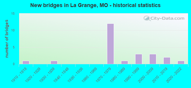
- New bridges - historical statistics
- 11910-1919
- 11930-1939
- 121970-1979
- 11980-1989
- 31990-1999
- 32000-2009
- 22010-2019
- 12020-2022


- Bridge Condition - Deck
- 5.6%Excellent
- 27.8%Very good
- 22.2%Good
- 22.2%Satisfactory
- 22.2%Fair

- Bridge Condition - Superstructure
- 5.6%Excellent
- 55.6%Good
- 22.2%Satisfactory
- 5.6%Fair
- 11.1%Serious

- Bridge Condition - Substructure
- 16.7%Excellent
- 11.1%Very good
- 22.2%Good
- 22.2%Satisfactory
- 27.8%Fair

- Bridge Condition - Channel
- 7.7%Very good
- 15.4%Good
- 69.2%Satisfactory
- 7.7%Fair
Find on map >> Show street view
Structure Number: 18763, Location: S 23 T 61 N R 6 W (Lat: 40.064583, Lng: -91.536778), Route carried "on" structure: County highway 198, Year Built: 1992, Status: Open, Structure Length: 2.13m (6.99ft), Average Daily Traffic: 50 (year 2020), Truck Traffic: 10%, Average Future Daily Traffic: 63 (year 2040), Features Intersected: LINN BR, Facility Carried by Structure: COUNTY RD 547
Minimum Vertical Clearance: 30+ m (98+ ft), Kilometerpoint: 1.609, Lanes on structure: 2, Owner: County Highway Agency, Approaching Roadway Width: 5.5m (18.0ft), Material/Design: Steel, Design/Construction: Stringer/Multi-beam, Number Of Spans In Main Unit: 1, Length of Maximum Span: 21.0m (68.9ft), Curb-To-Curb Width: 5.5m (18.0ft), Out-to-Out Width: 5.5m (18.0ft)
Condition: Deck: Very good, Superstructure: Good, Substructure: Fair, Channel: Satisfactory, Operating Rating: 45.9 metric tons, Method Used To Determine Operating Rating: Allowable Stress (AS), Inventory Rating: 28.8 metric tons, Method Used To Determine Inventory Rating: Allowable Stress (AS), Structural Evaluation: Somewhat better than minimum adequacy, Deck Geometry: Meets minimum limits, Waterway Adequacy: Equal to present minimum criteria, Approach Roadway Alignment: Equal to present desirable criteria, Designated Inspection Frequency: Every 24 months, Inspection Date: January 2022, Deck Structure Type: Concrete Cast-file-Place
Find on map >> Show street view
Structure Number: 20999, Location: S 6 T 60 N R 5 W (Lat: 40.024750, Lng: -91.493389), Route carried "on" structure: County highway 284, Year Built: 1910, Status: Posted for load, Structure Length: 1.43m (4.69ft), Average Daily Traffic: 15 (year 2020), Truck Traffic: 10%, Average Future Daily Traffic: 19 (year 2040), Features Intersected: OYSTER CR, Facility Carried by Structure: COUNTY RD 597
Minimum Vertical Clearance: 30+ m (98+ ft), Kilometerpoint: 1.448, Lanes on structure: 1, Owner: County Highway Agency, Approaching Roadway Width: 4.9m (16.1ft), Skew: 3 degrees, Material/Design: Steel, Design/Construction: Truss - Thru, Number Of Spans In Main Unit: 1, Length of Maximum Span: 13.7m (44.9ft), Curb-To-Curb Width: 5.4m (17.7ft), Out-to-Out Width: 5.5m (18.0ft)
Condition: Deck: Fair, Superstructure: Serious, Substructure: Fair, Channel: Satisfactory, Operating Rating: 18.9 metric tons, Method Used To Determine Operating Rating: Load Factor (LF), Inventory Rating: 10.8 metric tons, Method Used To Determine Inventory Rating: Load Factor (LF), Structural Evaluation: High priority of corrective action, Deck Geometry: High priority of corrective action, Waterway Adequacy: Somewhat better than minimum adequacy, Approach Roadway Alignment: Equal to present minimum criteria, Bridge Posting: Required (Relationship of Operating Rating to Maximum Legal Load: > 39.9% below), Length Of Structure Improvement: 0.21m (0.69ft), Designated Inspection Frequency: Every 24 months, Critical Feature Inspection Frequency: Every 24 months, Inspection Date: Febuary 2022, Critical Feature Inspection Date: Febuary 2022, Bridge Improvement Cost: $153,000, Roadway Improvement Cost: $15,000, Total Project Cost: $229,000 ( Estimate for 2022), Deck Structure Type: Concrete Cast-file-Place
Find on map >> Show street view
Structure Number: 21002, Location: S 19 T 60 N R 5 W (Lat: 39.982583, Lng: -91.493472), Route carried "on" structure: County highway 284, Year Built: 1930, Status: Posted for load, Structure Length: 2.47m (8.10ft), Average Daily Traffic: 30 (year 2020), Truck Traffic: 10%, Average Future Daily Traffic: 38 (year 2040), Features Intersected: DRAIN DTCH TO MISS, Facility Carried by Structure: COUNTY RD 597
Minimum Vertical Clearance: 30+ m (98+ ft), Kilometerpoint: 6.276, Lanes on structure: 1, Owner: County Highway Agency, Approaching Roadway Width: 5.5m (18.0ft), Material/Design: Steel, Design/Construction: Truss - Thru, Number Of Spans In Main Unit: 1, Length of Maximum Span: 24.4m (80.1ft), Curb-To-Curb Width: 5.4m (17.7ft), Out-to-Out Width: 5.5m (18.0ft)
Condition: Deck: Fair, Superstructure: Serious, Substructure: Fair, Channel: Satisfactory, Operating Rating: 15.3 metric tons, Method Used To Determine Operating Rating: Load Factor (LF), Inventory Rating: 10.8 metric tons, Method Used To Determine Inventory Rating: Load Factor (LF), Structural Evaluation: High priority of corrective action, Deck Geometry: High priority of corrective action, Waterway Adequacy: Somewhat better than minimum adequacy, Approach Roadway Alignment: Equal to present minimum criteria, Bridge Posting: Required (Relationship of Operating Rating to Maximum Legal Load: 30.0 - 39.9% below), Length Of Structure Improvement: 0.33m (1.08ft), Designated Inspection Frequency: Every 24 months, Critical Feature Inspection Frequency: Every 24 months, Inspection Date: January 2022, Critical Feature Inspection Date: January 2022, Bridge Improvement Cost: $240,000, Roadway Improvement Cost: $24,000, Total Project Cost: $360,000 ( Estimate for 2022), Deck Structure Type: Concrete Cast-file-Place
Find on map >> Show street view
Structure Number: 21018, Location: S 9 T 60 N R 6 W (Lat: 40.019250, Lng: -91.563194), Route carried "on" structure: County highway 285, Year Built: 1993, Status: Open, Structure Length: 2.29m (7.51ft), Average Daily Traffic: 65 (year 2020), Truck Traffic: 10%, Average Future Daily Traffic: 81 (year 2040), Features Intersected: DURGENS CR, Facility Carried by Structure: COUNTY RD 572
Minimum Vertical Clearance: 30+ m (98+ ft), Kilometerpoint: 2.092, Lanes on structure: 2, Owner: County Highway Agency, Approaching Roadway Width: 5.5m (18.0ft), Material/Design: Steel, Design/Construction: Stringer/Multi-beam, Number Of Spans In Main Unit: 1, Length of Maximum Span: 22.3m (73.2ft), Curb-To-Curb Width: 5.5m (18.0ft), Out-to-Out Width: 5.5m (18.0ft)
Condition: Deck: Very good, Superstructure: Good, Substructure: Fair, Channel: Satisfactory, Operating Rating: 89.1 metric tons, Method Used To Determine Operating Rating: Allowable Stress (AS), Inventory Rating: 72.0 metric tons, Method Used To Determine Inventory Rating: Allowable Stress (AS), Structural Evaluation: Somewhat better than minimum adequacy, Deck Geometry: Meets minimum limits, Waterway Adequacy: Equal to present minimum criteria, Approach Roadway Alignment: Equal to present desirable criteria, Designated Inspection Frequency: Every 24 months, Inspection Date: January 2022, Deck Structure Type: Concrete Cast-file-Place
Find on map >> Show street view
Structure Number: 21028, Location: S 1 T 60 N R 6 W (Lat: 40.028306, Lng: -91.515694), Route carried "on" structure: County highway 285, Year Built: 1998, Status: Open, Structure Length: 1.22m (4.00ft), Average Daily Traffic: 100 (year 2020), Truck Traffic: 10%, Average Future Daily Traffic: 125 (year 2040), Design Load: HS 20, Features Intersected: OYSTER BR, Facility Carried by Structure: COUNTY RD 572
Minimum Vertical Clearance: 30+ m (98+ ft), Kilometerpoint: 6.920, Lanes on structure: 2, Owner: County Highway Agency, Approaching Roadway Width: 5.5m (18.0ft), Material/Design: Steel, Design/Construction: Stringer/Multi-beam, Number Of Spans In Main Unit: 1, Length of Maximum Span: 11.9m (39.0ft), Curb-To-Curb Width: 5.5m (18.0ft), Out-to-Out Width: 5.5m (18.0ft)
Condition: Deck: Very good, Superstructure: Good, Substructure: Fair, Channel: Fair, Operating Rating: 89.1 metric tons, Method Used To Determine Operating Rating: Allowable Stress (AS), Inventory Rating: 63.9 metric tons, Method Used To Determine Inventory Rating: Allowable Stress (AS), Structural Evaluation: Somewhat better than minimum adequacy, Deck Geometry: Meets minimum limits, Waterway Adequacy: Somewhat better than minimum adequacy, Approach Roadway Alignment: Equal to present desirable criteria, Designated Inspection Frequency: Every 24 months, Inspection Date: January 2022, Deck Structure Type: Concrete Cast-file-Place
Find on map >> Show street view
Structure Number: 2698, Location: S 23 T 60 N R 6 W (Lat: 39.983389, Lng: -91.526703), Route carried "on" structure: US 61, Year Built: 1973, Status: Open, Structure Length: 4.69m (15.39ft), Average Daily Traffic: 6,100 (year 2021), Truck Traffic: 31%, Average Future Daily Traffic: 11,590 (year 2041), Design Load: HS 20, Features Intersected: DUNGENS CR
Minimum Vertical Clearance: 30+ m (98+ ft), Kilometerpoint: 58.001, Lanes on structure: 2, Base Highway Network: Yes, Owner: State Highway Agency, Approaching Roadway Width: 11.6m (38.1ft), Skew: 4 degrees, Material/Design: Prestressed concrete, Design/Construction: Stringer/Multi-beam, Number Of Spans In Main Unit: 3, Length of Maximum Span: 15.8m (51.8ft), Curb-To-Curb Width: 12.0m (39.4ft), Out-to-Out Width: 12.9m (42.3ft)
Condition: Deck: Satisfactory, Superstructure: Satisfactory, Substructure: Satisfactory, Channel: Satisfactory, Operating Rating: 63.9 metric tons, Method Used To Determine Operating Rating: Load Factor (LF), Inventory Rating: 37.8 metric tons, Method Used To Determine Inventory Rating: Load Factor (LF), Structural Evaluation: Equal to present minimum criteria, Deck Geometry: Better than present minimum criteria, Waterway Adequacy: Equal to present desirable criteria, Approach Roadway Alignment: Equal to present desirable criteria, Designated Inspection Frequency: Every 24 months, Inspection Date: October 2020, Deck Structure Type: Concrete Cast-file-Place, Wearing Surface/Protective System: Wearing Surface: Epoxy Overlay
Find on map >> Show street view
Structure Number: 2734, Location: S 23 T 60 N R 6 W (Lat: 39.982964, Lng: -91.525775), Route carried "on" structure: US 61, Year Built: 1973, Status: Open, Structure Length: 4.69m (15.39ft), Average Daily Traffic: 4,151 (year 2021), Truck Traffic: 32%, Average Future Daily Traffic: 7,887 (year 2041), Design Load: HS 20, Features Intersected: DUNGENS CR
Minimum Vertical Clearance: 30+ m (98+ ft), Kilometerpoint: 576.016, Lanes on structure: 2, Base Highway Network: Yes, Owner: State Highway Agency, Approaching Roadway Width: 11.0m (36.1ft), Skew: 4 degrees, Material/Design: Prestressed concrete, Design/Construction: Stringer/Multi-beam, Number Of Spans In Main Unit: 3, Length of Maximum Span: 15.8m (51.8ft), Curb-To-Curb Width: 12.0m (39.4ft), Out-to-Out Width: 12.9m (42.3ft)
Condition: Deck: Satisfactory, Superstructure: Satisfactory, Substructure: Good, Channel: Satisfactory, Operating Rating: 52.2 metric tons, Method Used To Determine Operating Rating: Load Factor (LF), Inventory Rating: 31.5 metric tons, Method Used To Determine Inventory Rating: Load Factor (LF), Structural Evaluation: Equal to present minimum criteria, Deck Geometry: Better than present minimum criteria, Waterway Adequacy: Equal to present desirable criteria, Approach Roadway Alignment: Equal to present desirable criteria, Designated Inspection Frequency: Every 24 months, Inspection Date: October 2020, Deck Structure Type: Concrete Cast-file-Place, Wearing Surface/Protective System: Wearing Surface: Epoxy Overlay
Find on map >> Show street view
Structure Number: 2877, Location: S 23 T 61 N R 6 W (Lat: 40.066497, Lng: -91.531078), Route carried "on" structure: US 61, Year Built: 1974, Year Reconstructed: 2004, Status: Open, Structure Length: 4.54m (14.90ft), Average Daily Traffic: 5,792 (year 2021), Truck Traffic: 38%, Average Future Daily Traffic: 11,005 (year 2041), Design Load: HS 20, Features Intersected: LINDEN BR
Minimum Vertical Clearance: 30+ m (98+ ft), Kilometerpoint: 48.686, Lanes on structure: 2, Base Highway Network: Yes, Owner: State Highway Agency, Approaching Roadway Width: 12.2m (40.0ft), Skew: 1 degrees, Material/Design: Concrete continuous, Design/Construction: Slab, Number Of Spans In Main Unit: 3, Length of Maximum Span: 15.2m (49.9ft), Curb-To-Curb Width: 13.4m (44.0ft), Out-to-Out Width: 14.3m (46.9ft)
Condition: Deck: Fair, Superstructure: Fair, Substructure: Good, Channel: Good, Operating Rating: 56.7 metric tons, Method Used To Determine Operating Rating: Load Factor (LF), Inventory Rating: 34.2 metric tons, Method Used To Determine Inventory Rating: Load Factor (LF), Structural Evaluation: Somewhat better than minimum adequacy, Deck Geometry: Superior to present desirable criteria, Waterway Adequacy: Equal to present minimum criteria, Approach Roadway Alignment: Equal to present desirable criteria, Designated Inspection Frequency: Every 24 months, Inspection Date: October 2020, Deck Structure Type: Concrete Cast-file-Place, Wearing Surface/Protective System: Wearing Surface: Epoxy Overlay, Deck Protection: Internally Sealed
Find on map >> Show street view
Structure Number: 2878, Location: S 26 T 61 N R 6 W (Lat: 40.048228, Lng: -91.525097), Route carried "on" structure: State highway C, Year Built: 1974, Status: Open, Structure Length: 7.92m (25.98ft), Average Daily Traffic: 601 (year 2021), Truck Traffic: 11%, Average Future Daily Traffic: 871 (year 2041), Design Load: H 20, Features Intersected: US 61
Minimum Vertical Clearance: 30+ m (98+ ft), Kilometerpoint: 20.221, Lanes on structure: 2, Lanes under structure: 4, Owner: State Highway Agency, Approaching Roadway Width: 6.1m (20.0ft), Material/Design: Steel continuous, Design/Construction: Stringer/Multi-beam, Number Of Spans In Main Unit: 2, Length of Maximum Span: 33.4m (109.6ft), Curb or Sidewalk Widths: Left: 0.2m (0.7ft), Right: 0.2m (0.7ft), Curb-To-Curb Width: 11.6m (38.1ft), Out-to-Out Width: 12.4m (40.7ft)
Condition: Deck: Fair, Superstructure: Good, Substructure: Satisfactory, Operating Rating: 57.6 metric tons, Method Used To Determine Operating Rating: Load Factor (LF), Inventory Rating: 34.2 metric tons, Method Used To Determine Inventory Rating: Load Factor (LF), Structural Evaluation: Equal to present minimum criteria, Deck Geometry: Better than present minimum criteria, Underclear: Better than present minimum criteria, Approach Roadway Alignment: Equal to present desirable criteria, Designated Inspection Frequency: Every 24 months, Inspection Date: October 2020, Deck Structure Type: Concrete Cast-file-Place
Find on map >> Show street view
Structure Number: 2879, Location: S 2 T 60 N R 6 W (Lat: 40.028042, Lng: -91.525933), Route carried "on" structure: US 61, Year Built: 1974, Year Reconstructed: 2004, Status: Open, Structure Length: 4.24m (13.91ft), Average Daily Traffic: 5,432 (year 2021), Truck Traffic: 31%, Average Future Daily Traffic: 10,321 (year 2041), Design Load: HS 20, Features Intersected: CRD 572 (OYSTER ST)
Minimum Vertical Clearance: 30+ m (98+ ft), Kilometerpoint: 53.033, Lanes on structure: 2, Lanes under structure: 2, Base Highway Network: Yes, Owner: State Highway Agency, Approaching Roadway Width: 12.2m (40.0ft), Skew: 2 degrees, Material/Design: Concrete continuous, Design/Construction: Slab, Number Of Spans In Main Unit: 3, Length of Maximum Span: 17.7m (58.1ft), Curb-To-Curb Width: 13.4m (44.0ft), Out-to-Out Width: 14.3m (46.9ft)
Condition: Deck: Satisfactory, Superstructure: Satisfactory, Substructure: Satisfactory, Operating Rating: 58.5 metric tons, Method Used To Determine Operating Rating: Load Factor (LF), Inventory Rating: 35.1 metric tons, Method Used To Determine Inventory Rating: Load Factor (LF), Structural Evaluation: Equal to present minimum criteria, Deck Geometry: Superior to present desirable criteria, Underclear: Equal to present minimum criteria, Approach Roadway Alignment: Equal to present desirable criteria, Designated Inspection Frequency: Every 24 months, Inspection Date: October 2020, Deck Structure Type: Concrete Cast-file-Place, Wearing Surface/Protective System: Wearing Surface: Epoxy Overlay
Find on map >> Show street view
Structure Number: 288, Location: S 11 T 60 N R 6 W (Lat: 40.011650, Lng: -91.526467), Route carried "on" structure: US 61, Year Built: 1974, Status: Open, Structure Length: 5.27m (17.29ft), Average Daily Traffic: 5,432 (year 2021), Truck Traffic: 31%, Average Future Daily Traffic: 10,321 (year 2041), Design Load: HS 20, Features Intersected: RT B
Minimum Vertical Clearance: 30+ m (98+ ft), Kilometerpoint: 54.858, Lanes on structure: 2, Lanes under structure: 2, Base Highway Network: Yes, Owner: State Highway Agency, Approaching Roadway Width: 11.6m (38.1ft), Skew: 3 degrees, Material/Design: Steel continuous, Design/Construction: Stringer/Multi-beam, Number Of Spans In Main Unit: 3, Length of Maximum Span: 21.9m (71.9ft), Curb-To-Curb Width: 12.0m (39.4ft), Out-to-Out Width: 12.9m (42.3ft)
Condition: Deck: Good, Superstructure: Good, Substructure: Good, Operating Rating: 50.4 metric tons, Method Used To Determine Operating Rating: Load Factor (LF), Inventory Rating: 30.6 metric tons, Method Used To Determine Inventory Rating: Load Factor (LF), Structural Evaluation: Better than present minimum criteria, Deck Geometry: Better than present minimum criteria, Underclear: Better than present minimum criteria, Approach Roadway Alignment: Equal to present desirable criteria, Designated Inspection Frequency: Every 24 months, Inspection Date: October 2020, Deck Structure Type: Concrete Cast-file-Place, Wearing Surface/Protective System: Wearing Surface: Bituminous, Deck Protection: Internally Sealed
Find on map >> Show street view
Structure Number: 2881, Location: S 11 T 60 N R 6 W (Lat: 40.011669, Lng: -91.526144), Route carried "on" structure: US 61, Year Built: 1974, Status: Open, Structure Length: 5.64m (18.50ft), Average Daily Traffic: 4,151 (year 2021), Truck Traffic: 32%, Average Future Daily Traffic: 7,887 (year 2041), Design Load: HS 20, Features Intersected: RT B
Minimum Vertical Clearance: 30+ m (98+ ft), Kilometerpoint: 579.193, Lanes on structure: 2, Lanes under structure: 2, Base Highway Network: Yes, Owner: State Highway Agency, Approaching Roadway Width: 11.6m (38.1ft), Skew: 3 degrees, Material/Design: Steel continuous, Design/Construction: Stringer/Multi-beam, Number Of Spans In Main Unit: 3, Length of Maximum Span: 21.9m (71.9ft), Curb-To-Curb Width: 12.0m (39.4ft), Out-to-Out Width: 12.9m (42.3ft)
Condition: Deck: Satisfactory, Superstructure: Good, Substructure: Good, Operating Rating: 51.3 metric tons, Method Used To Determine Operating Rating: Load Factor (LF), Inventory Rating: 30.6 metric tons, Method Used To Determine Inventory Rating: Load Factor (LF), Structural Evaluation: Better than present minimum criteria, Deck Geometry: Better than present minimum criteria, Underclear: Superior to present desirable criteria, Approach Roadway Alignment: Equal to present desirable criteria, Designated Inspection Frequency: Every 24 months, Inspection Date: October 2020, Deck Structure Type: Concrete Cast-file-Place, Wearing Surface/Protective System: Wearing Surface: Bituminous
Find on map >> Show street view
Structure Number: 29112, Location: S 23 T 61 N R 6 W (Lat: 40.066569, Lng: -91.530764), Route carried "on" structure: US 61, Year Built: 2001, Status: Open, Structure Length: 4.49m (14.73ft), Average Daily Traffic: 5,899 (year 2021), Truck Traffic: 33%, Average Future Daily Traffic: 11,208 (year 2041), Design Load: HS 25 or greater, Features Intersected: LINDEN BR
Minimum Vertical Clearance: 30+ m (98+ ft), Kilometerpoint: 585.390, Lanes on structure: 2, Base Highway Network: Yes, Owner: State Highway Agency, Approaching Roadway Width: 12.0m (39.4ft), Skew: 1 degrees, Material/Design: Prestressed concrete continuous, Design/Construction: Stringer/Multi-beam, Number Of Spans In Main Unit: 3, Length of Maximum Span: 15.5m (50.9ft), Curb-To-Curb Width: 11.4m (37.4ft), Out-to-Out Width: 12.2m (40.0ft)
Condition: Deck: Very good, Superstructure: Good, Substructure: Excellent, Channel: Good, Operating Rating: 83.7 metric tons, Method Used To Determine Operating Rating: Load Factor (LF), Inventory Rating: 50.4 metric tons, Method Used To Determine Inventory Rating: Load Factor (LF), Structural Evaluation: Better than present minimum criteria, Deck Geometry: Equal to present minimum criteria, Waterway Adequacy: Superior to present desirable criteria, Approach Roadway Alignment: Equal to present desirable criteria, Designated Inspection Frequency: Every 24 months, Inspection Date: October 2020, Deck Structure Type: Concrete Cast-file-Place, Wearing Surface/Protective System: Wearing Surface: Monolithic Concrete, Deck Protection: Epoxy Coated Reinforcing
Find on map >> Show street view
Structure Number: 29114, Location: S 2 T 60 N R 6 W (Lat: 40.027931, Lng: -91.525622), Route carried "on" structure: US 61, Year Built: 2001, Status: Open, Structure Length: 4.02m (13.19ft), Average Daily Traffic: 4,860 (year 2021), Truck Traffic: 32%, Average Future Daily Traffic: 9,234 (year 2041), Design Load: HS 25 or greater, Features Intersected: CRD 572 (OYSTER ST)
Minimum Vertical Clearance: 30+ m (98+ ft), Kilometerpoint: 581.018, Lanes on structure: 2, Lanes under structure: 2, Base Highway Network: Yes, Owner: State Highway Agency, Approaching Roadway Width: 12.0m (39.4ft), Skew: 2 degrees, Material/Design: Prestressed concrete continuous, Design/Construction: Stringer/Multi-beam, Number Of Spans In Main Unit: 3, Length of Maximum Span: 18.0m (59.1ft), Curb-To-Curb Width: 11.4m (37.4ft), Out-to-Out Width: 12.2m (40.0ft)
Condition: Deck: Very good, Superstructure: Good, Substructure: Satisfactory, Operating Rating: 90.0 metric tons, Method Used To Determine Operating Rating: Load Factor (LF), Inventory Rating: 54.0 metric tons, Method Used To Determine Inventory Rating: Load Factor (LF), Structural Evaluation: Equal to present minimum criteria, Deck Geometry: Equal to present minimum criteria, Underclear: Superior to present desirable criteria, Approach Roadway Alignment: Equal to present desirable criteria, Designated Inspection Frequency: Every 24 months, Inspection Date: October 2020, Deck Structure Type: Concrete Cast-file-Place, Wearing Surface/Protective System: Wearing Surface: Monolithic Concrete, Deck Protection: Epoxy Coated Reinforcing
Find on map >> Show street view
Structure Number: 3427, Location: S 15 T 60 N R 6 W (Lat: 39.990278, Lng: -91.550278), Route carried "on" structure: County highway 287, Year Built: 2013, Status: Open, Structure Length: 3.66m (12.01ft), Average Daily Traffic: 50 (year 2020), Truck Traffic: 10%, Average Future Daily Traffic: 63 (year 2040), Design Load: HS 20+Mod, Features Intersected: DURGENS CR, Facility Carried by Structure: COUNTY RD 588
Minimum Vertical Clearance: 30+ m (98+ ft), Kilometerpoint: 1.609, Lanes on structure: 2, Owner: County Highway Agency, Approaching Roadway Width: 5.5m (18.0ft), Material/Design: Steel, Design/Construction: Stringer/Multi-beam, Number Of Spans In Main Unit: 1, Length of Maximum Span: 35.1m (115.2ft), Curb-To-Curb Width: 7.3m (24.0ft), Out-to-Out Width: 7.5m (24.6ft)
Condition: Deck: Good, Superstructure: Good, Substructure: Excellent, Channel: Satisfactory, Operating Rating: 72.0 metric tons, Method Used To Determine Operating Rating: Load Factor (LF), Inventory Rating: 33.3 metric tons, Method Used To Determine Inventory Rating: Load Factor (LF), Structural Evaluation: Better than present minimum criteria, Deck Geometry: Equal to present minimum criteria, Waterway Adequacy: Better than present minimum criteria, Approach Roadway Alignment: Equal to present desirable criteria, Designated Inspection Frequency: Every 24 months, Inspection Date: Febuary 2022, Deck Structure Type: Concrete Cast-file-Place, Wearing Surface/Protective System: Wearing Surface: Monolithic Concrete
Find on map >> Show street view
Structure Number: 344, Location: S 30 T 61 N R 5 W (Lat: 40.058908, Lng: -91.498797), Route carried "on" structure: State highway B, Year Built: 2013, Status: Open, Structure Length: 6.32m (20.73ft), Average Daily Traffic: 823 (year 2021), Truck Traffic: 12%, Average Future Daily Traffic: 1,193 (year 2041), Features Intersected: WYACONDA RVR
Minimum Vertical Clearance: 30+ m (98+ ft), Kilometerpoint: 13.564, Lanes on structure: 2, Owner: State Highway Agency, Approaching Roadway Width: 8.5m (27.9ft), Material/Design: Prestressed concrete continuous, Design/Construction: Box Beam or Girders - Single/Spread, Number Of Spans In Main Unit: 3, Length of Maximum Span: 21.3m (69.9ft), Curb-To-Curb Width: 8.5m (27.9ft), Out-to-Out Width: 9.3m (30.5ft)
Condition: Deck: Good, Superstructure: Good, Substructure: Very good, Channel: Satisfactory, Operating Rating: 52.2 metric tons, Method Used To Determine Operating Rating: Load Factor (LF), Inventory Rating: 31.5 metric tons, Method Used To Determine Inventory Rating: Load Factor (LF), Structural Evaluation: Better than present minimum criteria, Deck Geometry: Somewhat better than minimum adequacy, Waterway Adequacy: Superior to present desirable criteria, Approach Roadway Alignment: Equal to present desirable criteria, Designated Inspection Frequency: Every 24 months, Underwater Inspection Frequency: Every 60 months, Inspection Date: October 2021, Underwater Inspection Date: September 2021, Deck Structure Type: Concrete Cast-file-Place, Wearing Surface/Protective System: Wearing Surface: Monolithic Concrete, Deck Protection: Epoxy Coated Reinforcing
Find on map >> Show street view
Structure Number: 3499, Location: S 1 T 60 N R 6 W (Lat: 40.025028, Lng: -91.506869), Route carried "on" structure: State highway B, Year Built: 1984, Status: Open, Structure Length: 1.52m (4.99ft), Average Daily Traffic: 1,987 (year 2021), Truck Traffic: 11%, Average Future Daily Traffic: 2,881 (year 2041), Design Load: H 20, Features Intersected: OYSTER BR
Minimum Vertical Clearance: 30+ m (98+ ft), Kilometerpoint: 17.566, Lanes on structure: 2, Owner: State Highway Agency, Approaching Roadway Width: 12.2m (40.0ft), Skew: 1 degrees, Material/Design: Prestressed concrete, Design/Construction: Tee Beam, Number Of Spans In Main Unit: 1, Length of Maximum Span: 15.2m (49.9ft), Curb or Sidewalk Widths: Left: 0.2m (0.7ft), Right: 0.2m (0.7ft), Curb-To-Curb Width: 11.8m (38.7ft), Out-to-Out Width: 12.6m (41.3ft)
Condition: Deck: Good, Superstructure: Satisfactory, Substructure: Very good, Channel: Satisfactory, Operating Rating: 55.8 metric tons, Method Used To Determine Operating Rating: Allowable Stress (AS), Inventory Rating: 25.2 metric tons, Method Used To Determine Inventory Rating: Allowable Stress (AS), Structural Evaluation: Equal to present minimum criteria, Deck Geometry: Equal to present minimum criteria, Waterway Adequacy: Equal to present desirable criteria, Approach Roadway Alignment: Equal to present desirable criteria, Designated Inspection Frequency: Every 24 months, Inspection Date: October 2020, Deck Structure Type: Concrete Cast-file-Place, Wearing Surface/Protective System: Wearing Surface: Monolithic Concrete
Find on map >> Show street view
Structure Number: 36557, Location: S 28 T 61 N R 6 W (Lat: 40.049031, Lng: -91.571139), Route carried "on" structure: State highway C, Year Built: 2021, Status: Open, Structure Length: 4.07m (13.35ft), Average Daily Traffic: 515 (year 2021), Truck Traffic: 11%, Average Future Daily Traffic: 747 (year 2041), Features Intersected: DURGNS CR
Minimum Vertical Clearance: 30+ m (98+ ft), Kilometerpoint: 16.217, Lanes on structure: 2, Owner: State Highway Agency, Approaching Roadway Width: 7.3m (24.0ft), Material/Design: Prestressed concrete continuous, Design/Construction: Stringer/Multi-beam, Number Of Spans In Main Unit: 3, Length of Maximum Span: 15.2m (49.9ft), Curb-To-Curb Width: 7.3m (24.0ft), Out-to-Out Width: 8.1m (26.6ft)
Condition: Deck: Excellent, Superstructure: Excellent, Substructure: Excellent, Channel: Very good, Operating Rating: 68.4 metric tons, Method Used To Determine Operating Rating: Load Factor (LF), Inventory Rating: 40.5 metric tons, Method Used To Determine Inventory Rating: Load Factor (LF), Structural Evaluation: Superior to present desirable criteria, Deck Geometry: Meets minimum limits, Waterway Adequacy: Superior to present desirable criteria, Approach Roadway Alignment: Equal to present desirable criteria, Designated Inspection Frequency: Every 24 months, Inspection Date: October 2021, Deck Structure Type: Concrete Cast-file-Place, Wearing Surface/Protective System: Wearing Surface: Monolithic Concrete, Deck Protection: Epoxy Coated Reinforcing
Find on map >> Show street view
Structure Number: 2878, Location: S 26 T 61 N R 6 W (Lat: 40.048228, Lng: -91.525097), Route carried "under" structure: US 61, Year Built: 1974, Structure Length: 0. m, Average Daily Traffic: 5,792 (year 2021), Truck Traffic: 38%, Features Intersected: US 61, Facility Carried by Structure: RT C E
Minimum Vertical Clearance: 4.93m (16.17ft), Kilometerpoint: 50.822, Lanes on structure: 2, Lanes under structure: 2, Material/Design: Steel continuous, Design/Construction: Stringer/Multi-beam, Length of Maximum Span: 33.4m (109.6ft)
Find on map >> Show street view
Structure Number: 2878, Location: S 26 T 61 N R 6 W (Lat: 40.048228, Lng: -91.525097), Route carried "under" structure: US 61, Year Built: 1974, Structure Length: 0. m, Average Daily Traffic: 4,860 (year 2021), Truck Traffic: 32%, Features Intersected: US 61, Facility Carried by Structure: RT C E
Minimum Vertical Clearance: 5.03m (16.50ft), Kilometerpoint: 583.292, Lanes on structure: 2, Lanes under structure: 2, Material/Design: Steel continuous, Design/Construction: Stringer/Multi-beam, Length of Maximum Span: 33.4m (109.6ft)
Find on map >> Show street view
Structure Number: 2879, Location: S 2 T 60 N R 6 W (Lat: 40.028042, Lng: -91.525933), Route carried "under" structure: County highway , Year Built: 1974, Structure Length: 0. m, Average Daily Traffic: 226 (year 2021), Truck Traffic: 10%, Features Intersected: CRD 572 (OYSTER ST), Facility Carried by Structure: US 61 S
Minimum Vertical Clearance: 5.69m (18.67ft), Kilometerpoint: 5.684, Lanes on structure: 2, Lanes under structure: 2, Material/Design: Concrete continuous, Design/Construction: Slab, Length of Maximum Span: 17.7m (58.1ft)
Find on map >> Show street view
Structure Number: 288, Location: S 11 T 60 N R 6 W (Lat: 40.011650, Lng: -91.526467), Route carried "under" structure: State highway B, Year Built: 1974, Structure Length: 0. m, Average Daily Traffic: 1,987 (year 2021), Truck Traffic: 11%, Features Intersected: RT B, Facility Carried by Structure: US 61 S
Minimum Vertical Clearance: 4.88m (16.01ft), Kilometerpoint: 19.908, Lanes on structure: 2, Lanes under structure: 2, Material/Design: Steel continuous, Design/Construction: Stringer/Multi-beam, Length of Maximum Span: 21.9m (71.9ft)
Find on map >> Show street view
Structure Number: 2881, Location: S 11 T 60 N R 6 W (Lat: 40.011669, Lng: -91.526144), Route carried "under" structure: State highway B, Year Built: 1974, Structure Length: 0. m, Average Daily Traffic: 1,987 (year 2021), Truck Traffic: 11%, Features Intersected: RT B, Facility Carried by Structure: US 61 N
Minimum Vertical Clearance: 5.79m (19.00ft), Kilometerpoint: 19.877, Lanes on structure: 2, Lanes under structure: 2, Material/Design: Steel continuous, Design/Construction: Stringer/Multi-beam, Length of Maximum Span: 21.9m (71.9ft)
Find on map >> Show street view
Structure Number: 29114, Location: S 2 T 60 N R 6 W (Lat: 40.027931, Lng: -91.525622), Route carried "under" structure: County highway , Year Built: 2001, Structure Length: 0. m, Average Daily Traffic: 226 (year 2021), Truck Traffic: 10%, Features Intersected: CRD 572 (OYSTER ST), Facility Carried by Structure: US 61 N
Minimum Vertical Clearance: 5.66m (18.57ft), Kilometerpoint: 5.710, Lanes on structure: 2, Lanes under structure: 2, Material/Design: Prestressed concrete continuous, Design/Construction: Stringer/Multi-beam, Length of Maximum Span: 18.0m (59.1ft)