Bridge Statistics for La Palma, California (CA)
Condition, Traffic, Stress, Structural Evaluation, Project Costs
- National Bridge Inventory (NBI) Statistics
- 10Number of bridges
- 174ft / 53.1mTotal length
- 1,341,100Total average daily traffic
- 97,672Total average daily truck traffic
- National Bridge Inventory (NBI) Registered Bridges for La Palma
- No street view available for this location
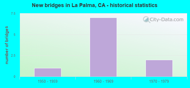
- New bridges - historical statistics
- 11950-1959
- 71960-1969
- 21970-1979
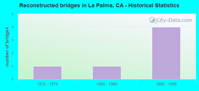
- Reconstructed bridges - Historical Statistics
- 11970-1979
- 11980-1989
- 41990-1999
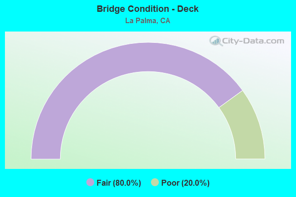
- Bridge Condition - Deck
- 80.0%Fair
- 20.0%Poor
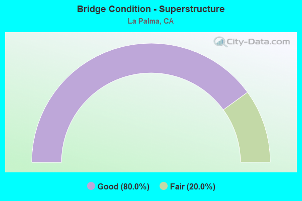
- Bridge Condition - Superstructure
- 80.0%Good
- 20.0%Fair
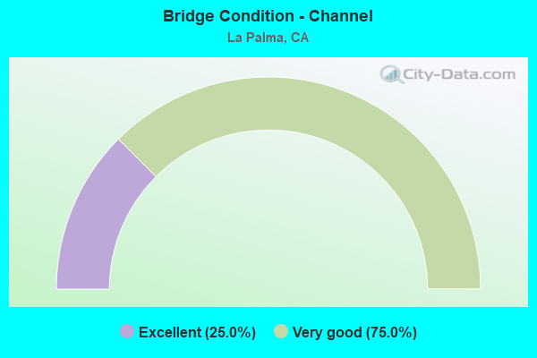
- Bridge Condition - Channel
- 25.0%Excellent
- 75.0%Very good
Find on map >> Show street view
Structure Number: 55 0301, Location: 12-ORA-091-R2.85-BPK (Lat: 33.855864, Lng: -117.993939), Route carried "on" structure: State highway 91, Year Built: 1970, Year Reconstructed: 1998, Status: Open, Structure Length: 3.84m (12.60ft), Average Daily Traffic: 268,000 (year 2012), Truck Traffic: 8%, Average Future Daily Traffic: 299,000 (year 2040), Design Load: HS 20, Features Intersected: STANTON AVE
Minimum Vertical Clearance: 30+ m (98+ ft), Kilometerpoint: 2.850, Lanes on structure: 12, Lanes under structure: 4, Base Highway Network: Yes (, Subroute: 1), Owner: State Highway Agency, Approaching Roadway Width: 53.7m (176.2ft), Skew: 30 degrees, Material/Design: Prestressed concrete, Design/Construction: Box Beam or Girders - Multiple, Number Of Spans In Main Unit: 1, Length of Maximum Span: 37.8m (124.0ft), Curb-To-Curb Width: 53.7m (176.2ft), Out-to-Out Width: 55.3m (181.4ft)
Condition: Deck: Fair, Superstructure: Good, Substructure: Good, Operating Rating: 54.1 metric tons, Method Used To Determine Operating Rating: Assigned rating based on Load Factor Design (LFD) reported in metric tons, Inventory Rating: 32.4 metric tons, Method Used To Determine Inventory Rating: Assigned rating based on Load Factor Design (LFD) reported in metric tons, Structural Evaluation: Better than present minimum criteria, Deck Geometry: Superior to present desirable criteria, Underclear: Meets minimum limits, Approach Roadway Alignment: Equal to present desirable criteria, Designated Inspection Frequency: Every 24 months, Inspection Date: December 2020, Deck Structure Type: Concrete Cast-file-Place
Find on map >> Show street view
Structure Number: 55 0306, Location: 12-ORA-091-R0.10-LPMA (Lat: 33.861250, Lng: -118.040500), Route carried "on" structure: State highway 91, Year Built: 1969, Year Reconstructed: 1998, Status: Open, Structure Length: 8.53m (27.99ft), Average Daily Traffic: 235,500 (year 2012), Truck Traffic: 8%, Average Future Daily Traffic: 271,000 (year 2040), Design Load: HS 20, Features Intersected: COYOTE CREEK
Minimum Vertical Clearance: 30+ m (98+ ft), Kilometerpoint: 0.100, Lanes on structure: 10, Base Highway Network: Yes (, Subroute: 1), Owner: State Highway Agency, Approaching Roadway Width: 46.4m (152.2ft), Skew: 31 degrees, Material/Design: Concrete continuous, Design/Construction: Box Beam or Girders - Multiple, Number Of Spans In Main Unit: 3, Length of Maximum Span: 33.5m (109.9ft), Curb-To-Curb Width: 46.4m (152.2ft), Out-to-Out Width: 48.0m (157.5ft)
Condition: Deck: Fair, Superstructure: Good, Substructure: Good, Channel: Very good, Operating Rating: 54.1 metric tons, Method Used To Determine Operating Rating: Assigned rating based on Load Factor Design (LFD) reported in metric tons, Inventory Rating: 32.4 metric tons, Method Used To Determine Inventory Rating: Assigned rating based on Load Factor Design (LFD) reported in metric tons, Structural Evaluation: Better than present minimum criteria, Deck Geometry: Superior to present desirable criteria, Waterway Adequacy: Equal to present desirable criteria, Approach Roadway Alignment: Equal to present desirable criteria, Designated Inspection Frequency: Every 24 months, Inspection Date: December 2020, Deck Structure Type: Concrete Cast-file-Place
Find on map >> Show street view
Structure Number: 55 0308, Location: 12-ORA-091-R0.28-LPMA (Lat: 33.860117, Lng: -118.037781), Route carried "on" structure: State highway 91, Year Built: 1969, Year Reconstructed: 1998, Status: Open, Structure Length: 5.04m (16.54ft), Average Daily Traffic: 235,500 (year 2012), Truck Traffic: 8%, Average Future Daily Traffic: 271,000 (year 2040), Design Load: HS 20, Features Intersected: WALKER STREET
Minimum Vertical Clearance: 30+ m (98+ ft), Kilometerpoint: 0.280, Lanes on structure: 11, Lanes under structure: 4, Base Highway Network: Yes (, Subroute: 1), Owner: State Highway Agency, Approaching Roadway Width: 52.1m (170.9ft), Skew: 32 degrees, Material/Design: Concrete continuous, Design/Construction: Box Beam or Girders - Multiple, Number Of Spans In Main Unit: 3, Length of Maximum Span: 28.0m (91.9ft), Curb-To-Curb Width: 52.1m (170.9ft), Out-to-Out Width: 53.5m (175.5ft)
Condition: Deck: Fair, Superstructure: Fair, Substructure: Good, Operating Rating: 54.1 metric tons, Method Used To Determine Operating Rating: Assigned rating based on Load Factor Design (LFD) reported in metric tons, Inventory Rating: 32.4 metric tons, Method Used To Determine Inventory Rating: Assigned rating based on Load Factor Design (LFD) reported in metric tons, Structural Evaluation: Somewhat better than minimum adequacy, Deck Geometry: Superior to present desirable criteria, Underclear: High priority of corrective action, Approach Roadway Alignment: Equal to present desirable criteria, Designated Inspection Frequency: Every 24 months, Inspection Date: December 2020, Deck Structure Type: Concrete Cast-file-Place
Find on map >> Show street view
Structure Number: 55 0309, Location: 12-ORA-091-R0.54-LPMA (Lat: 33.858917, Lng: -118.034806), Route carried "on" structure: State highway 91, Year Built: 1969, Year Reconstructed: 1998, Status: Open, Structure Length: 7.80m (25.59ft), Average Daily Traffic: 265,000 (year 2012), Truck Traffic: 6%, Average Future Daily Traffic: 295,000 (year 2040), Design Load: HS 20, Features Intersected: ORANGETHORPE AVE
Minimum Vertical Clearance: 7.62m (25.00ft), Kilometerpoint: 0.540, Lanes on structure: 10, Lanes under structure: 6, Base Highway Network: Yes (, Subroute: 1), Owner: State Highway Agency, Approaching Roadway Width: 46.4m (152.2ft), Skew: 36 degrees, Material/Design: Prestressed concrete continuous, Design/Construction: Box Beam or Girders - Multiple, Number Of Spans In Main Unit: 2, Length of Maximum Span: 38.4m (126.0ft), Curb-To-Curb Width: 46.4m (152.2ft), Out-to-Out Width: 48.0m (157.5ft)
Condition: Deck: Fair, Superstructure: Good, Substructure: Good, Operating Rating: 54.1 metric tons, Method Used To Determine Operating Rating: Assigned rating based on Load Factor Design (LFD) reported in metric tons, Inventory Rating: 32.4 metric tons, Method Used To Determine Inventory Rating: Assigned rating based on Load Factor Design (LFD) reported in metric tons, Structural Evaluation: Better than present minimum criteria, Deck Geometry: Superior to present desirable criteria, Underclear: Meets minimum limits, Approach Roadway Alignment: Equal to present desirable criteria, Designated Inspection Frequency: Every 24 months, Inspection Date: December 2020, Deck Structure Type: Concrete Cast-file-Place
Find on map >> Show street view
Structure Number: 55C0111, Location: 0.3 MI. S/O ROUTE 91 FWY. (Lat: 33.847664, Lng: -117.835672), Route carried "on" structure: City street , Year Built: 1967, Year Reconstructed: 1980, Status: Open, Structure Length: 26.29m (86.25ft), Average Daily Traffic: 19,800 (year 2017), Truck Traffic: 3%, Average Future Daily Traffic: 46,407 (year 2039), Design Load: HS 20, Features Intersected: SANTA ANA RIVER CHANNEL, Facility Carried by Structure: TUSTIN AVENUE
Minimum Vertical Clearance: 30+ m (98+ ft), Kilometerpoint: 0.000, Lanes on structure: 4, Base Highway Network: Yes, Owner: City or Municipal Highway Agency, Approaching Roadway Width: 25.0m (82.0ft), Skew: 9 degrees, Material/Design: Concrete continuous, Design/Construction: Tee Beam, Number Of Spans In Main Unit: 13, Length of Maximum Span: 20.7m (67.9ft), Curb or Sidewalk Widths: Left: 1.6m (5.2ft), Right: 0.0m, Curb-To-Curb Width: 20.4m (66.9ft), Out-to-Out Width: 22.9m (75.1ft)
Condition: Deck: Poor, Superstructure: Good, Substructure: Good, Channel: Very good, Operating Rating: 71.6 metric tons, Method Used To Determine Operating Rating: Load Factor (LF), Inventory Rating: 62.5 metric tons, Method Used To Determine Inventory Rating: Load Factor (LF), Structural Evaluation: Better than present minimum criteria, Deck Geometry: Superior to present desirable criteria, Waterway Adequacy: Superior to present desirable criteria, Approach Roadway Alignment: Better than present minimum criteria, Designated Inspection Frequency: Every 24 months, Inspection Date: August 2021, Deck Structure Type: Concrete Cast-file-Place
Find on map >> Show street view
Structure Number: 55C0116, Location: 0.15 MI. S/O LA PALMA AVE (Lat: 33.844347, Lng: -118.037047), Route carried "on" structure: City street , Year Built: 1978, Status: Open, Structure Length: 0.67m (2.20ft), Average Daily Traffic: 20,100 (year 2013), Truck Traffic: 1%, Average Future Daily Traffic: 42,469 (year 2037), Design Load: HS 20, Features Intersected: MOODY CREEK CHANNEL, Facility Carried by Structure: WALKER STREET
Minimum Vertical Clearance: 30+ m (98+ ft), Kilometerpoint: 0.000, Lanes on structure: 5, Owner: City or Municipal Highway Agency, Approaching Roadway Width: 19.2m (63.0ft), Material/Design: Concrete continuous, Design/Construction: Culvert, Number Of Spans In Main Unit: 2, Length of Maximum Span: 3.0m (9.8ft), Curb or Sidewalk Widths: Left: 2.7m (8.9ft), Right: 2.4m (7.9ft), Curb-To-Curb Width: 19.2m (63.0ft), Out-to-Out Width: 28.3m (92.8ft)
Condition: Channel: Excellent, Culverts: Good, Operating Rating: 54.1 metric tons, Method Used To Determine Operating Rating: Field evaluation and documented engineering judgment, Inventory Rating: 32.4 metric tons, Method Used To Determine Inventory Rating: Field evaluation and documented engineering judgment, Structural Evaluation: Better than present minimum criteria, Deck Geometry: Meets minimum limits, Waterway Adequacy: Superior to present desirable criteria, Approach Roadway Alignment: Equal to present desirable criteria, Designated Inspection Frequency: Every 48 months, Inspection Date: June 2019
Find on map >> Show street view
Structure Number: 55C0145, Location: 0.2 MI. S/O LA PALMA AVE (Lat: 33.843350, Lng: -118.045764), Route carried "on" structure: City street , Year Built: 1958, Year Reconstructed: 1975, Status: Open, Structure Length: 0.91m (2.99ft), Average Daily Traffic: 21,700 (year 2013), Truck Traffic: 1%, Average Future Daily Traffic: 49,493 (year 2041), Features Intersected: MOODY CREEK CHANNEL, Facility Carried by Structure: MOODY STREET
Minimum Vertical Clearance: 30+ m (98+ ft), Kilometerpoint: 0.000, Lanes on structure: 5, Base Highway Network: Yes, Owner: City or Municipal Highway Agency, Approaching Roadway Width: 23.8m (78.1ft), Skew: 33 degrees, Material/Design: Concrete continuous, Design/Construction: Culvert, Number Of Spans In Main Unit: 2, Length of Maximum Span: 4.3m (14.1ft), Curb or Sidewalk Widths: Left: 2.4m (7.9ft), Right: 2.4m (7.9ft), Curb-To-Curb Width: 23.8m (78.1ft), Out-to-Out Width: 32.0m (105.0ft)
Condition: Channel: Very good, Culverts: Good, Operating Rating: 40.5 metric tons, Method Used To Determine Operating Rating: Field evaluation and documented engineering judgment, Inventory Rating: 24.3 metric tons, Method Used To Determine Inventory Rating: Field evaluation and documented engineering judgment, Structural Evaluation: Equal to present minimum criteria, Deck Geometry: Better than present minimum criteria, Waterway Adequacy: Equal to present desirable criteria, Approach Roadway Alignment: Equal to present desirable criteria, Designated Inspection Frequency: Every 24 months, Inspection Date: Febuary 2021
Find on map >> Show street view
Structure Number: 55 0308, Location: 12-ORA-091-R0.28-LPMA (Lat: 33.860117, Lng: -118.037781), Route carried "under" structure: City street , Year Built: 1969, Structure Length: 0. m, Average Daily Traffic: 10,000 (year 2012), Truck Traffic: 7%, Features Intersected: WALKER STREET, Facility Carried by Structure: STATE ROUTE 91
Minimum Vertical Clearance: 4.87m (15.98ft), Kilometerpoint: 0.000, Lanes on structure: 11, Lanes under structure: 4, Material/Design: Concrete continuous, Design/Construction: Box Beam or Girders - Multiple, Length of Maximum Span: 28.0m (91.9ft)
Find on map >> Show street view
Structure Number: 55 0309, Location: 12-ORA-091-R0.54-LPMA (Lat: 33.858917, Lng: -118.034806), Route carried "under" structure: City street , Year Built: 1969, Structure Length: 0. m, Average Daily Traffic: 30,000 (year 2012), Truck Traffic: 7%, Features Intersected: ORANGETHORPE AVE, Facility Carried by Structure: STATE ROUTE 91
Minimum Vertical Clearance: 5.08m (16.67ft), Kilometerpoint: 0.000, Lanes on structure: 10, Lanes under structure: 6, Material/Design: Prestressed concrete continuous, Design/Construction: Box Beam or Girders - Multiple, Length of Maximum Span: 38.4m (126.0ft)
Find on map >> Show street view
Structure Number: 55 0473, Location: 12-ORA-091-R0.02-LPMA (Lat: 33.862336, Lng: -118.041569), Route carried "under" structure: State highway 91, Year Built: 1969, Structure Length: 0. m, Average Daily Traffic: 235,500 (year 2009), Truck Traffic: 8%, Features Intersected: STATE ROUTE 91, Facility Carried by Structure: PEDESTRIAN WALKWAY
Minimum Vertical Clearance: 5.00m (16.40ft), Kilometerpoint: 0.020, Lanes under structure: 10, Material/Design: Prestressed concrete continuous, Design/Construction: Box Beam or Girders - Single/Spread, Length of Maximum Span: 27.4m (89.9ft)