Bridge Statistics for La Presa, California (CA)
Condition, Traffic, Stress, Structural Evaluation, Project Costs
- National Bridge Inventory (NBI) Statistics
- 26Number of bridges
- 610ft / 186mTotal length
- 519,406Total average daily traffic
- 12,064Total average daily truck traffic
- National Bridge Inventory (NBI) Registered Bridges for La Presa
- No street view available for this location
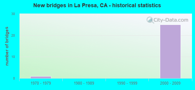
- New bridges - historical statistics
- 11970-1979
- 252000-2009


- Bridge Condition - Deck
- 41.7%Good
- 58.3%Fair

- Bridge Condition - Substructure
- 58.3%Good
- 41.7%Fair

- Bridge Condition - Channel
- 50.0%Excellent
- 50.0%Very good

- Bridge Condition - Culverts
- 50.0%Good
- 50.0%Satisfactory
Find on map >> Show street view
Structure Number: 57 1040L, Location: 11-SD-125-9.66 (Lat: 32.700967, Lng: -117.011361), Route carried "on" structure: State highway 125, Year Built: 2002, Status: Open, Structure Length: 9.10m (29.86ft), Average Daily Traffic: 58,500 (year 2018), Truck Traffic: 4%, Average Future Daily Traffic: 71,650 (year 2042), Design Load: HS 20, Features Intersected: ELKELTON PLACE
Minimum Vertical Clearance: 30+ m (98+ ft), Kilometerpoint: 9.660, Lanes on structure: 3, Lanes under structure: 5, Base Highway Network: Yes (Inventory Route: 1, Subroute: 1), Owner: State Highway Agency, Approaching Roadway Width: 16.8m (55.1ft), Skew: 3 degrees, Material/Design: Prestressed concrete continuous, Design/Construction: Box Beam or Girders - Multiple, Number Of Spans In Main Unit: 2, Length of Maximum Span: 54.0m (177.2ft), Curb-To-Curb Width: 16.8m (55.1ft), Out-to-Out Width: 17.8m (58.4ft)
Condition: Deck: Good, Superstructure: Good, Substructure: Good, Operating Rating: 54.1 metric tons, Method Used To Determine Operating Rating: Assigned rating based on Load Factor Design (LFD) reported in metric tons, Inventory Rating: 32.4 metric tons, Method Used To Determine Inventory Rating: Assigned rating based on Load Factor Design (LFD) reported in metric tons, Structural Evaluation: Better than present minimum criteria, Deck Geometry: Equal to present minimum criteria, Underclear: Superior to present desirable criteria, Approach Roadway Alignment: Equal to present desirable criteria, Designated Inspection Frequency: Every 24 months, Inspection Date: July 2020, Deck Structure Type: Concrete Cast-file-Place
Find on map >> Show street view
Structure Number: 57 1040R, Location: 11-SD-125-9.66 (Lat: 32.700569, Lng: -117.011025), Route carried "on" structure: State highway 125, Year Built: 2002, Status: Open, Structure Length: 10.13m (33.23ft), Average Daily Traffic: 58,500 (year 2018), Truck Traffic: 4%, Average Future Daily Traffic: 71,650 (year 2042), Design Load: HS 20, Features Intersected: ELKELTON PLACE
Minimum Vertical Clearance: 30+ m (98+ ft), Kilometerpoint: 9.660, Lanes on structure: 4, Lanes under structure: 5, Base Highway Network: Yes (Inventory Route: 1, Subroute: 1), Owner: State Highway Agency, Approaching Roadway Width: 20.2m (66.3ft), Skew: 3 degrees, Material/Design: Prestressed concrete continuous, Design/Construction: Box Beam or Girders - Multiple, Number Of Spans In Main Unit: 2, Length of Maximum Span: 57.6m (189.0ft), Curb-To-Curb Width: 20.2m (66.3ft), Out-to-Out Width: 21.2m (69.6ft)
Condition: Deck: Fair, Superstructure: Good, Substructure: Good, Operating Rating: 54.1 metric tons, Method Used To Determine Operating Rating: Assigned rating based on Load Factor Design (LFD) reported in metric tons, Inventory Rating: 32.4 metric tons, Method Used To Determine Inventory Rating: Assigned rating based on Load Factor Design (LFD) reported in metric tons, Structural Evaluation: Better than present minimum criteria, Deck Geometry: Equal to present minimum criteria, Underclear: Superior to present desirable criteria, Approach Roadway Alignment: Equal to present desirable criteria, Designated Inspection Frequency: Every 24 months, Inspection Date: July 2020, Deck Structure Type: Concrete Cast-file-Place
Find on map >> Show street view
Structure Number: 57 1041S, Location: 11-SD-125-9.77 (Lat: 32.702689, Lng: -117.010500), Route carried "on" structure: Ramp State highway 125, Year Built: 2002, Status: Open, Structure Length: 9.13m (29.95ft), Average Daily Traffic: 12,400 (year 2016), Truck Traffic: 1%, Average Future Daily Traffic: 12,900 (year 2037), Design Load: HS 20, Features Intersected: ELKELTON PLACE-N125 RAMP
Minimum Vertical Clearance: 30+ m (98+ ft), Kilometerpoint: 9.770, Lanes on structure: 1, Lanes under structure: 2, Owner: State Highway Agency, Approaching Roadway Width: 7.3m (24.0ft), Material/Design: Prestressed concrete continuous, Design/Construction: Box Beam or Girders - Multiple, Number Of Spans In Main Unit: 3, Length of Maximum Span: 43.8m (143.7ft), Curb-To-Curb Width: 7.3m (24.0ft), Out-to-Out Width: 8.3m (27.2ft)
Condition: Deck: Fair, Superstructure: Good, Substructure: Good, Operating Rating: 54.1 metric tons, Method Used To Determine Operating Rating: Assigned rating based on Load Factor Design (LFD) reported in metric tons, Inventory Rating: 32.4 metric tons, Method Used To Determine Inventory Rating: Assigned rating based on Load Factor Design (LFD) reported in metric tons, Structural Evaluation: Better than present minimum criteria, Deck Geometry: Better than present minimum criteria, Underclear: Better than present minimum criteria, Approach Roadway Alignment: Equal to present desirable criteria, Designated Inspection Frequency: Every 24 months, Inspection Date: July 2020, Deck Structure Type: Concrete Cast-file-Place
Find on map >> Show street view
Structure Number: 57 1042K, Location: 11-SD-125-9.76 (Lat: 32.702797, Lng: -117.011297), Route carried "on" structure: Ramp State highway 125, Year Built: 2002, Status: Open, Structure Length: 6.20m (20.34ft), Average Daily Traffic: 10,800 (year 2016), Truck Traffic: 1%, Average Future Daily Traffic: 11,297 (year 2042), Design Load: HS 20, Features Intersected: N125-ELKELTON PL RAMP
Minimum Vertical Clearance: 30+ m (98+ ft), Kilometerpoint: 9.760, Lanes on structure: 2, Lanes under structure: 2, Owner: State Highway Agency, Approaching Roadway Width: 12.0m (39.4ft), Skew: 2 degrees, Material/Design: Prestressed concrete continuous, Design/Construction: Box Beam or Girders - Multiple, Number Of Spans In Main Unit: 3, Length of Maximum Span: 29.0m (95.1ft), Curb-To-Curb Width: 12.0m (39.4ft), Out-to-Out Width: 13.0m (42.7ft)
Condition: Deck: Good, Superstructure: Good, Substructure: Good, Operating Rating: 54.1 metric tons, Method Used To Determine Operating Rating: Assigned rating based on Load Factor Design (LFD) reported in metric tons, Inventory Rating: 32.4 metric tons, Method Used To Determine Inventory Rating: Assigned rating based on Load Factor Design (LFD) reported in metric tons, Structural Evaluation: Better than present minimum criteria, Deck Geometry: Superior to present desirable criteria, Underclear: Equal to present minimum criteria, Approach Roadway Alignment: Equal to present desirable criteria, Designated Inspection Frequency: Every 48 months, Inspection Date: July 2020, Deck Structure Type: Concrete Cast-file-Place
Find on map >> Show street view
Structure Number: 57 1043, Location: 11-SD-125-9.79 (Lat: 32.703589, Lng: -117.011539), Route carried "on" structure: City street , Year Built: 2002, Status: Open, Structure Length: 16.76m (54.99ft), Average Daily Traffic: 22,900 (year 2015), Truck Traffic: 1%, Average Future Daily Traffic: 26,367 (year 2042), Design Load: HS 20, Features Intersected: STATE ROUTE 125, Facility Carried by Structure: PARADISE VALLEY RD
Minimum Vertical Clearance: 30+ m (98+ ft), Kilometerpoint: 0.000, Lanes on structure: 6, Lanes under structure: 8, Owner: State Highway Agency, Approaching Roadway Width: 27.0m (88.6ft), Skew: 4 degrees, Material/Design: Prestressed concrete continuous, Design/Construction: Box Beam or Girders - Multiple, Number Of Spans In Main Unit: 3, Length of Maximum Span: 51.5m (169.0ft), Curb or Sidewalk Widths: Left: 1.5m (4.9ft), Right: 1.5m (4.9ft), Curb-To-Curb Width: 27.0m (88.6ft), Out-to-Out Width: 30.6m (100.4ft)
Condition: Deck: Good, Superstructure: Good, Substructure: Good, Operating Rating: 54.1 metric tons, Method Used To Determine Operating Rating: Assigned rating based on Load Factor Design (LFD) reported in metric tons, Inventory Rating: 32.4 metric tons, Method Used To Determine Inventory Rating: Assigned rating based on Load Factor Design (LFD) reported in metric tons, Structural Evaluation: Better than present minimum criteria, Deck Geometry: Better than present minimum criteria, Underclear: Equal to present minimum criteria, Approach Roadway Alignment: Equal to present desirable criteria, Designated Inspection Frequency: Every 24 months, Inspection Date: July 2020, Deck Structure Type: Concrete Cast-file-Place
Find on map >> Show street view
Structure Number: 57 1173L, Location: 11-SD-054-6.00 (Lat: 32.691336, Lng: -117.017333), Route carried "on" structure: State highway 54, Year Built: 2007, Status: Open, Structure Length: 7.75m (25.43ft), Average Daily Traffic: 44,500 (year 2012), Truck Traffic: 1%, Average Future Daily Traffic: 63,500 (year 2040), Design Load: HS 20+Mod, Features Intersected: SWEETWATER RD & W54-S125
Minimum Vertical Clearance: 30+ m (98+ ft), Kilometerpoint: 6.000, Lanes on structure: 3, Lanes under structure: 3, Base Highway Network: Yes (, Subroute: 1), Owner: State Highway Agency, Approaching Roadway Width: 16.8m (55.1ft), Skew: 3 degrees, Material/Design: Prestressed concrete continuous, Design/Construction: Box Beam or Girders - Multiple, Number Of Spans In Main Unit: 2, Length of Maximum Span: 40.2m (131.9ft), Curb-To-Curb Width: 16.8m (55.1ft), Out-to-Out Width: 17.7m (58.1ft)
Condition: Deck: Fair, Superstructure: Good, Substructure: Fair, Operating Rating: 54.1 metric tons, Method Used To Determine Operating Rating: Assigned rating based on Load Factor Design (LFD) reported in metric tons, Inventory Rating: 32.4 metric tons, Method Used To Determine Inventory Rating: Assigned rating based on Load Factor Design (LFD) reported in metric tons, Structural Evaluation: Somewhat better than minimum adequacy, Deck Geometry: Equal to present minimum criteria, Underclear: Somewhat better than minimum adequacy, Approach Roadway Alignment: Equal to present desirable criteria, Designated Inspection Frequency: Every 24 months, Inspection Date: June 2020, Deck Structure Type: Concrete Cast-file-Place
Find on map >> Show street view
Structure Number: 57 1177G, Location: 11-SD-125-8.53R (Lat: 32.687722, Lng: -117.011672), Route carried "on" structure: Ramp State highway 125, Year Built: 2008, Status: Open, Structure Length: 49.90m (163.71ft), Average Daily Traffic: 8,900 (year 2018), Truck Traffic: 1%, Average Future Daily Traffic: 9,500 (year 2037), Design Load: HS 20+Mod, Features Intersected: SWEETWATER RIVER
Minimum Vertical Clearance: 5.64m (18.50ft), Kilometerpoint: 8.530, Lanes on structure: 2, Base Highway Network: Yes (Inventory Route: 1, Subroute: 1), Toll: On toll road, Owner: State Highway Agency, Approaching Roadway Width: 11.7m (38.4ft), Skew: 9 degrees, Material/Design: Prestressed concrete continuous, Design/Construction: Box Beam or Girders - Multiple, Number Of Spans In Main Unit: 9, Length of Maximum Span: 90.0m (295.3ft), Curb-To-Curb Width: 11.7m (38.4ft), Out-to-Out Width: 12.6m (41.3ft)
Condition: Deck: Fair, Superstructure: Good, Substructure: Good, Channel: Excellent, Operating Rating: 54.1 metric tons, Method Used To Determine Operating Rating: Assigned rating based on Load Factor Design (LFD) reported in metric tons, Inventory Rating: 32.4 metric tons, Method Used To Determine Inventory Rating: Assigned rating based on Load Factor Design (LFD) reported in metric tons, Structural Evaluation: Better than present minimum criteria, Deck Geometry: Superior to present desirable criteria, Waterway Adequacy: Superior to present desirable criteria, Approach Roadway Alignment: Equal to present desirable criteria, Designated Inspection Frequency: Every 24 months, Inspection Date: June 2020, Deck Structure Type: Concrete Cast-file-Place
Find on map >> Show street view
Structure Number: 57 1178G, Location: 11-SD-125-8.97L (Lat: 32.690800, Lng: -117.017061), Route carried "on" structure: Ramp State highway 125, Year Built: 2008, Status: Open, Structure Length: 6.20m (20.34ft), Average Daily Traffic: 8,900 (year 2018), Truck Traffic: 1%, Average Future Daily Traffic: 10,000 (year 2037), Design Load: HS 20, Features Intersected: SWEETWATER RD
Minimum Vertical Clearance: 30+ m (98+ ft), Kilometerpoint: 8.970, Lanes on structure: 2, Lanes under structure: 3, Owner: State Highway Agency, Approaching Roadway Width: 11.7m (38.4ft), Skew: 9 degrees, Material/Design: Prestressed concrete continuous, Design/Construction: Box Beam or Girders - Multiple, Number Of Spans In Main Unit: 2, Length of Maximum Span: 35.6m (116.8ft), Curb-To-Curb Width: 11.7m (38.4ft), Out-to-Out Width: 12.6m (41.3ft)
Condition: Deck: Fair, Superstructure: Good, Substructure: Fair, Operating Rating: 54.1 metric tons, Method Used To Determine Operating Rating: Assigned rating based on Load Factor Design (LFD) reported in metric tons, Inventory Rating: 32.4 metric tons, Method Used To Determine Inventory Rating: Assigned rating based on Load Factor Design (LFD) reported in metric tons, Structural Evaluation: Somewhat better than minimum adequacy, Deck Geometry: Superior to present desirable criteria, Underclear: Better than present minimum criteria, Approach Roadway Alignment: Equal to present desirable criteria, Designated Inspection Frequency: Every 24 months, Inspection Date: June 2020, Deck Structure Type: Concrete Cast-file-Place
Find on map >> Show street view
Structure Number: 57 1179G, Location: 11-SD-054-6.10 (Lat: 32.690044, Lng: -117.016864), Route carried "on" structure: Ramp State highway 54, Year Built: 2008, Status: Open, Structure Length: 4.50m (14.76ft), Average Daily Traffic: 2,000 (year 2012), Truck Traffic: 1%, Average Future Daily Traffic: 5,118 (year 2040), Design Load: HS 20+Mod, Features Intersected: SWEETWATER ROAD
Minimum Vertical Clearance: 30+ m (98+ ft), Kilometerpoint: 6.100, Lanes on structure: 1, Lanes under structure: 2, Owner: State Highway Agency, Approaching Roadway Width: 11.7m (38.4ft), Skew: 9 degrees, Material/Design: Prestressed concrete, Design/Construction: Box Beam or Girders - Multiple, Number Of Spans In Main Unit: 1, Length of Maximum Span: 45.0m (147.6ft), Curb-To-Curb Width: 11.7m (38.4ft), Out-to-Out Width: 12.6m (41.3ft)
Condition: Deck: Fair, Superstructure: Good, Substructure: Fair, Operating Rating: 54.1 metric tons, Method Used To Determine Operating Rating: Assigned rating based on Load Factor Design (LFD) reported in metric tons, Inventory Rating: 32.4 metric tons, Method Used To Determine Inventory Rating: Assigned rating based on Load Factor Design (LFD) reported in metric tons, Structural Evaluation: Somewhat better than minimum adequacy, Deck Geometry: Superior to present desirable criteria, Underclear: Somewhat better than minimum adequacy, Approach Roadway Alignment: Equal to present desirable criteria, Designated Inspection Frequency: Every 24 months, Inspection Date: June 2020, Deck Structure Type: Concrete Cast-file-Place
Find on map >> Show street view
Structure Number: 57 1180G, Location: 11-SD-054-6.20 (Lat: 32.689936, Lng: -117.015583), Route carried "on" structure: Ramp State highway 54, Year Built: 2008, Status: Open, Structure Length: 45.40m (148.95ft), Average Daily Traffic: 4,000 (year 2012), Truck Traffic: 1%, Average Future Daily Traffic: 10,236 (year 2040), Design Load: HS 20+Mod, Features Intersected: SWEETWATER RIVER
Minimum Vertical Clearance: 30+ m (98+ ft), Kilometerpoint: 6.200, Lanes on structure: 2, Base Highway Network: Yes (, Subroute: 1), Owner: State Highway Agency, Approaching Roadway Width: 11.7m (38.4ft), Skew: 9 degrees, Material/Design: Prestressed concrete continuous, Design/Construction: Box Beam or Girders - Multiple, Number Of Spans In Main Unit: 8, Length of Maximum Span: 88.0m (288.7ft), Curb-To-Curb Width: 11.7m (38.4ft), Out-to-Out Width: 12.6m (41.3ft)
Condition: Deck: Fair, Superstructure: Good, Substructure: Fair, Channel: Very good, Operating Rating: 54.1 metric tons, Method Used To Determine Operating Rating: Assigned rating based on Load Factor Design (LFD) reported in metric tons, Inventory Rating: 32.4 metric tons, Method Used To Determine Inventory Rating: Assigned rating based on Load Factor Design (LFD) reported in metric tons, Structural Evaluation: Somewhat better than minimum adequacy, Deck Geometry: Superior to present desirable criteria, Waterway Adequacy: Superior to present desirable criteria, Approach Roadway Alignment: Equal to present desirable criteria, Designated Inspection Frequency: Every 24 months, Inspection Date: June 2020, Deck Structure Type: Concrete Cast-file-Place
Find on map >> Show street view
Structure Number: 57 1182L, Location: 11-SD-054-6.07 (Lat: 32.692164, Lng: -117.016472), Route carried "on" structure: State highway 54, Year Built: 2008, Status: Open, Structure Length: 11.10m (36.42ft), Average Daily Traffic: 46,500 (year 2012), Truck Traffic: 1%, Average Future Daily Traffic: 71,650 (year 2040), Design Load: HS 20+Mod, Features Intersected: SPRING VALLEY
Minimum Vertical Clearance: 30+ m (98+ ft), Kilometerpoint: 6.070, Lanes on structure: 3, Base Highway Network: Yes (, Subroute: 1), Owner: State Highway Agency, Approaching Roadway Width: 16.8m (55.1ft), Skew: 4 degrees, Material/Design: Prestressed concrete continuous, Design/Construction: Box Beam or Girders - Multiple, Number Of Spans In Main Unit: 3, Length of Maximum Span: 50.5m (165.7ft), Curb-To-Curb Width: 16.8m (55.1ft), Out-to-Out Width: 17.7m (58.1ft)
Condition: Deck: Good, Superstructure: Good, Substructure: Good, Operating Rating: 54.1 metric tons, Method Used To Determine Operating Rating: Assigned rating based on Load Factor Design (LFD) reported in metric tons, Inventory Rating: 32.4 metric tons, Method Used To Determine Inventory Rating: Assigned rating based on Load Factor Design (LFD) reported in metric tons, Structural Evaluation: Better than present minimum criteria, Deck Geometry: Equal to present minimum criteria, Approach Roadway Alignment: Equal to present desirable criteria, Designated Inspection Frequency: Every 24 months, Inspection Date: June 2020, Deck Structure Type: Concrete Cast-file-Place
Find on map >> Show street view
Structure Number: 57 1182R, Location: 11-SD-054-6.07 (Lat: 32.691703, Lng: -117.016408), Route carried "on" structure: State highway 54, Year Built: 2008, Status: Open, Structure Length: 7.80m (25.59ft), Average Daily Traffic: 46,500 (year 2012), Truck Traffic: 1%, Average Future Daily Traffic: 71,650 (year 2040), Design Load: HS 20+Mod, Features Intersected: SPRING VALLEY
Minimum Vertical Clearance: 30+ m (98+ ft), Kilometerpoint: 6.070, Lanes on structure: 3, Base Highway Network: Yes (, Subroute: 1), Owner: State Highway Agency, Approaching Roadway Width: 16.8m (55.1ft), Skew: 4 degrees, Material/Design: Prestressed concrete continuous, Design/Construction: Box Beam or Girders - Multiple, Number Of Spans In Main Unit: 3, Length of Maximum Span: 30.8m (101.0ft), Curb-To-Curb Width: 16.8m (55.1ft), Out-to-Out Width: 17.7m (58.1ft)
Condition: Deck: Good, Superstructure: Good, Substructure: Fair, Operating Rating: 54.1 metric tons, Method Used To Determine Operating Rating: Assigned rating based on Load Factor Design (LFD) reported in metric tons, Inventory Rating: 32.4 metric tons, Method Used To Determine Inventory Rating: Assigned rating based on Load Factor Design (LFD) reported in metric tons, Structural Evaluation: Somewhat better than minimum adequacy, Deck Geometry: Equal to present minimum criteria, Approach Roadway Alignment: Equal to present desirable criteria, Designated Inspection Frequency: Every 24 months, Inspection Date: June 2020, Deck Structure Type: Concrete Cast-file-Place
Find on map >> Show street view
Structure Number: 57C0407, Location: 0.23MI E/O SWEETWATER RD (Lat: 32.730297, Lng: -117.010550), Route carried "on" structure: County highway , Year Built: 1977, Year Reconstructed: 1987, Status: Open, Structure Length: 1.58m (5.18ft), Average Daily Traffic: 2,110 (year 2016), Truck Traffic: 1%, Average Future Daily Traffic: 2,557 (year 2038), Features Intersected: SPRING VALLEY CREEK, Facility Carried by Structure: TYLER STREET
Minimum Vertical Clearance: 30+ m (98+ ft), Kilometerpoint: 0.000, Lanes on structure: 2, Owner: County Highway Agency, Approaching Roadway Width: 9.8m (32.2ft), Skew: 4 degrees, Material/Design: Concrete, Design/Construction: Culvert, Number Of Spans In Main Unit: 3, Length of Maximum Span: 4.9m (16.1ft), Curb or Sidewalk Widths: Left: 1.2m (3.9ft), Right: 1.2m (3.9ft), Curb-To-Curb Width: 9.8m (32.2ft), Out-to-Out Width: 15.8m (51.8ft)
Condition: Channel: Excellent, Culverts: Good, Operating Rating: 54.1 metric tons, Method Used To Determine Operating Rating: Field evaluation and documented engineering judgment, Inventory Rating: 32.4 metric tons, Method Used To Determine Inventory Rating: Field evaluation and documented engineering judgment, Structural Evaluation: Better than present minimum criteria, Deck Geometry: Meets minimum limits, Waterway Adequacy: Superior to present desirable criteria, Approach Roadway Alignment: Equal to present desirable criteria, Designated Inspection Frequency: Every 48 months, Inspection Date: May 2021, Deck Structure Type: Concrete Cast-file-Place, Wearing Surface/Protective System: Wearing Surface: Bituminous
Find on map >> Show street view
Structure Number: 57C0795, Location: 20FT S/O JAMACHA BLVD (Lat: 32.707531, Lng: -117.005694), Route carried "on" structure: City street , Year Built: 2009, Status: Open, Structure Length: 0.80m (2.62ft), Average Daily Traffic: 996 (year 2016), Truck Traffic: 2%, Average Future Daily Traffic: 1,126 (year 2038), Features Intersected: SWEETWATER RIV TRIBUTARY, Facility Carried by Structure: RUXTON AVENUE
Minimum Vertical Clearance: 30+ m (98+ ft), Kilometerpoint: 0.000, Lanes on structure: 2, Owner: County Highway Agency, Approaching Roadway Width: 11.0m (36.1ft), Material/Design: Concrete continuous, Design/Construction: Culvert, Number Of Spans In Main Unit: 3, Length of Maximum Span: 2.4m (7.9ft), Curb or Sidewalk Widths: Left: 4.4m (14.4ft), Right: 4.4m (14.4ft), Curb-To-Curb Width: 11.0m (36.1ft), Out-to-Out Width: 20.4m (66.9ft)
Condition: Channel: Very good, Culverts: Satisfactory, Operating Rating: 54.1 metric tons, Method Used To Determine Operating Rating: Field evaluation and documented engineering judgment, Inventory Rating: 32.4 metric tons, Method Used To Determine Inventory Rating: Field evaluation and documented engineering judgment, Structural Evaluation: Equal to present minimum criteria, Deck Geometry: Better than present minimum criteria, Waterway Adequacy: Equal to present desirable criteria, Approach Roadway Alignment: Equal to present desirable criteria, Designated Inspection Frequency: Every 48 months, Inspection Date: May 2021, Deck Structure Type: Concrete Cast-file-Place
Find on map >> Show street view
Structure Number: 57 1040K, Location: 11-SD-125-9.67 (Lat: 32.701175, Lng: -117.011539), Route carried "under" structure: City street , Year Built: 2002, Structure Length: 0. m, Average Daily Traffic: 5,100 (year 2015), Truck Traffic: 1%, Features Intersected: ELKELTON PLACE, Facility Carried by Structure: S125 & 54 ON RAMP
Minimum Vertical Clearance: 5.59m (18.34ft), Kilometerpoint: 0.000, Lanes on structure: 3, Lanes under structure: 4, Material/Design: Prestressed concrete continuous, Design/Construction: Box Beam or Girders - Multiple, Length of Maximum Span: 50.5m (165.7ft)
Find on map >> Show street view
Structure Number: 57 1040L, Location: 11-SD-125-9.66 (Lat: 32.700967, Lng: -117.011361), Route carried "under" structure: City street , Year Built: 2002, Structure Length: 0. m, Average Daily Traffic: 5,100 (year 2015), Truck Traffic: 1%, Features Intersected: ELKELTON PLACE, Facility Carried by Structure: ROUTE 125
Minimum Vertical Clearance: 7.18m (23.56ft), Kilometerpoint: 0.000, Lanes on structure: 3, Lanes under structure: 5, Material/Design: Prestressed concrete continuous, Design/Construction: Box Beam or Girders - Multiple, Length of Maximum Span: 54.0m (177.2ft)
Find on map >> Show street view
Structure Number: 57 1040R, Location: 11-SD-125-9.66 (Lat: 32.700569, Lng: -117.011025), Route carried "under" structure: City street , Year Built: 2002, Structure Length: 0. m, Average Daily Traffic: 5,100 (year 2015), Truck Traffic: 1%, Features Intersected: ELKELTON PLACE, Facility Carried by Structure: ROUTE 125
Minimum Vertical Clearance: 10.97m (35.99ft), Kilometerpoint: 0.000, Lanes on structure: 4, Lanes under structure: 5, Material/Design: Prestressed concrete continuous, Design/Construction: Box Beam or Girders - Multiple, Length of Maximum Span: 57.6m (189.0ft)
Find on map >> Show street view
Structure Number: 57 1041S, Location: 11-SD-125-9.77 (Lat: 32.702689, Lng: -117.010500), Route carried "under" structure: Ramp State highway 125, Year Built: 2002, Structure Length: 0. m, Average Daily Traffic: 8,800 (year 2016), Truck Traffic: 1%, Features Intersected: ELKELTON PLACE-N125 RAMP
Minimum Vertical Clearance: 5.16m (16.93ft), Kilometerpoint: 9.770, Lanes on structure: 1, Lanes under structure: 2, Material/Design: Prestressed concrete continuous, Design/Construction: Box Beam or Girders - Multiple, Length of Maximum Span: 43.8m (143.7ft)
Find on map >> Show street view
Structure Number: 57 1042K, Location: 11-SD-125-9.76 (Lat: 32.702797, Lng: -117.011297), Route carried "under" structure: Ramp State highway 125, Year Built: 2002, Structure Length: 0. m, Average Daily Traffic: 9,900 (year 2016), Truck Traffic: 1%, Features Intersected: N125-ELKELTON PL RAMP
Minimum Vertical Clearance: 6.38m (20.93ft), Kilometerpoint: 9.760, Lanes on structure: 2, Lanes under structure: 2, Material/Design: Prestressed concrete continuous, Design/Construction: Box Beam or Girders - Multiple, Length of Maximum Span: 29.0m (95.1ft)
Find on map >> Show street view
Structure Number: 57 1043, Location: 11-SD-125-9.79 (Lat: 32.703589, Lng: -117.011539), Route carried "under" structure: Ramp State highway 125, Year Built: 2002, Structure Length: 0. m, Average Daily Traffic: 9,000 (year 2018), Truck Traffic: 1%, Features Intersected: STATE ROUTE 125, Facility Carried by Structure: PARADISE VALLEY RD
Minimum Vertical Clearance: 7.12m (23.36ft), Kilometerpoint: 9.790, Lanes on structure: 6, Lanes under structure: 1, Material/Design: Prestressed concrete continuous, Design/Construction: Box Beam or Girders - Multiple, Length of Maximum Span: 51.5m (169.0ft)
Find on map >> Show street view
Structure Number: 57 1043, Location: 11-SD-125-9.79 (Lat: 32.703589, Lng: -117.011539), Route carried "under" structure: State highway 125, Year Built: 2002, Structure Length: 0. m, Average Daily Traffic: 111,700 (year 2018), Truck Traffic: 4%, Features Intersected: STATE ROUTE 125, Facility Carried by Structure: PARADISE VALLEY RD
Minimum Vertical Clearance: 5.64m (18.50ft), Kilometerpoint: 9.790, Lanes on structure: 6, Lanes under structure: 7, Material/Design: Prestressed concrete continuous, Design/Construction: Box Beam or Girders - Multiple, Length of Maximum Span: 51.5m (169.0ft)
Find on map >> Show street view
Structure Number: 57 1173L, Location: 11-SD-054-6.00 (Lat: 32.691336, Lng: -117.017333), Route carried "under" structure: City street , Year Built: 2007, Structure Length: 0. m, Average Daily Traffic: 5,000 (year 2012), Truck Traffic: 1%, Features Intersected: SWEETWATER RD & W54-S125, Facility Carried by Structure: STATE ROUTE 54 WB
Minimum Vertical Clearance: 9.58m (31.43ft), Kilometerpoint: 0.000, Lanes on structure: 3, Lanes under structure: 2, Material/Design: Prestressed concrete continuous, Design/Construction: Box Beam or Girders - Multiple, Length of Maximum Span: 40.2m (131.9ft)
Find on map >> Show street view
Structure Number: 57 1173L, Location: 11-SD-054-6.00 (Lat: 32.691336, Lng: -117.017333), Route carried "under" structure: Ramp State highway 54, Year Built: 2007, Structure Length: 0. m, Average Daily Traffic: 2,000 (year 2012), Truck Traffic: 1%, Features Intersected: SWEETWATER RD & W54-S125
Minimum Vertical Clearance: 16.60m (54.46ft), Kilometerpoint: 6.000, Lanes on structure: 3, Lanes under structure: 1, Material/Design: Prestressed concrete continuous, Design/Construction: Box Beam or Girders - Multiple, Length of Maximum Span: 40.2m (131.9ft)
Find on map >> Show street view
Structure Number: 57 1178G, Location: 11-SD-125-8.97L (Lat: 32.690800, Lng: -117.017061), Route carried "under" structure: Ramp State highway 54, Year Built: 2008, Structure Length: 0. m, Average Daily Traffic: 8,200 (year 2018), Truck Traffic: 1%, Features Intersected: SWEETWATER RD
Minimum Vertical Clearance: 5.12m (16.80ft), Kilometerpoint: 6.000, Lanes on structure: 2, Lanes under structure: 1, Material/Design: Prestressed concrete continuous, Design/Construction: Box Beam or Girders - Multiple, Length of Maximum Span: 35.6m (116.8ft)
Find on map >> Show street view
Structure Number: 57 1178G, Location: 11-SD-125-8.97L (Lat: 32.690800, Lng: -117.017061), Route carried "under" structure: City street , Year Built: 2008, Structure Length: 0. m, Average Daily Traffic: 17,000 (year 2015), Truck Traffic: 1%, Features Intersected: SWEETWATER RD, Facility Carried by Structure: NB 125-WB 54 CONN
Minimum Vertical Clearance: 5.21m (17.09ft), Kilometerpoint: 0.000, Lanes on structure: 2, Lanes under structure: 2, Material/Design: Prestressed concrete continuous, Design/Construction: Box Beam or Girders - Multiple, Length of Maximum Span: 35.6m (116.8ft)
Find on map >> Show street view
Structure Number: 57 1179G, Location: 11-SD-054-6.10 (Lat: 32.690044, Lng: -117.016864), Route carried "under" structure: City street , Year Built: 2008, Structure Length: 0. m, Average Daily Traffic: 5,000 (year 2012), Truck Traffic: 1%, Features Intersected: SWEETWATER ROAD, Facility Carried by Structure: E54-S125 CONNECTOR
Minimum Vertical Clearance: 4.64m (15.22ft), Kilometerpoint: 0.000, Lanes on structure: 1, Lanes under structure: 2, Material/Design: Prestressed concrete, Design/Construction: Box Beam or Girders - Multiple, Length of Maximum Span: 45.0m (147.6ft)