Bridge Statistics for LaFayette, New York (NY)
Condition, Traffic, Stress, Structural Evaluation, Project Costs
- National Bridge Inventory (NBI) Statistics
- 24Number of bridges
- 118ft / 36.3mTotal length
- $23,678,000Total costs
- 75,419Total average daily traffic
- 7,155Total average daily truck traffic
- National Bridge Inventory (NBI) Registered Bridges for LaFayette
- No street view available for this location
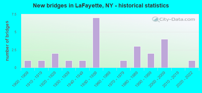
- New bridges - historical statistics
- 11900-1909
- 11910-1919
- 21920-1929
- 11930-1939
- 11940-1949
- 71950-1959
- 11970-1979
- 31980-1989
- 21990-1999
- 42000-2009
- 12020-2022

- Reconstructed bridges - Historical Statistics
- 11960-1969
- 01970-1979
- 01980-1989
- 41990-1999


- Bridge Condition - Deck
- 41.2%Good
- 29.4%Satisfactory
- 17.6%Fair
- 11.8%Poor

- Bridge Condition - Superstructure
- 5.9%Very good
- 35.3%Good
- 35.3%Satisfactory
- 11.8%Fair
- 11.8%Poor

- Bridge Condition - Substructure
- 29.4%Good
- 52.9%Satisfactory
- 11.8%Fair
- 5.9%Critical

- Bridge Condition - Channel
- 6.3%Good
- 25.0%Satisfactory
- 50.0%Fair
- 18.8%Poor

- Bridge Condition - Culverts
- 50.0%Satisfactory
- 50.0%Fair
Find on map >> Show street view
Structure Number: 10091, Location: JCT OF RTS 20 & 11A (Lat: 42.891622, Lng: -76.144592), Route carried "on" structure: US 20, Year Built: 2001, Status: Open, Structure Length: 4.21m (13.81ft), Average Daily Traffic: 4,364 (year 2018), Truck Traffic: 9%, Average Future Daily Traffic: 4,512 (year 2040), Design Load: HS 25 or greater, Features Intersected: RTE 11A
Minimum Vertical Clearance: 30+ m (98+ ft), Kilometerpoint: 27.096, Lanes on structure: 2, Lanes under structure: 2, Base Highway Network: Yes, Owner: State Highway Agency, Approaching Roadway Width: 15.8m (51.8ft), Skew: 3 degrees, Material/Design: Steel, Design/Construction: Stringer/Multi-beam, Number Of Spans In Main Unit: 1, Length of Maximum Span: 40.5m (132.9ft), Curb-To-Curb Width: 15.9m (52.2ft), Out-to-Out Width: 16.7m (54.8ft)
Condition: Deck: Good, Superstructure: Good, Substructure: Good, Operating Rating: 17.5 metric tons, Method Used To Determine Operating Rating: Load and Resistance Factor Rating (LRFR) rating reported by rating factor(RF) method using HL-93 loadings, Inventory Rating: 13.6 metric tons, Method Used To Determine Inventory Rating: Load and Resistance Factor Rating (LRFR) rating reported by rating factor(RF) method using HL-93 loadings, Structural Evaluation: Meets minimum limits, Deck Geometry: Superior to present desirable criteria, Underclear: Equal to present minimum criteria, Approach Roadway Alignment: Equal to present desirable criteria, Length Of Structure Improvement: 4.20m (13.78ft), Designated Inspection Frequency: Every 24 months, Inspection Date: August 2020, Bridge Improvement Cost: $1,781,000, Roadway Improvement Cost: $1,043,000, Total Project Cost: $2,824,000 ( Estimate for 2021), Deck Structure Type: Concrete Cast-file-Place, Wearing Surface/Protective System: Wearing Surface: Integral Concrete, Deck Protection: Epoxy Coated Reinforcing
Find on map >> Show street view
Structure Number: 101576, Location: 1.3 MI NW JCT US20 &US11A (Lat: 42.900139, Lng: -76.168939), Route carried "on" structure: US 20, Year Built: 2004, Status: Open, Structure Length: 3.96m (12.99ft), Average Daily Traffic: 3,535 (year 2018), Truck Traffic: 9%, Average Future Daily Traffic: 3,655 (year 2040), Design Load: HL 93, Features Intersected: Onondaga Creek
Minimum Vertical Clearance: 30+ m (98+ ft), Kilometerpoint: 24.891, Lanes on structure: 2, Base Highway Network: Yes, Owner: State Highway Agency, Approaching Roadway Width: 12.2m (40.0ft), Skew: 4 degrees, Material/Design: Steel, Design/Construction: Stringer/Multi-beam, Number Of Spans In Main Unit: 1, Length of Maximum Span: 39.0m (128.0ft), Curb-To-Curb Width: 12.2m (40.0ft), Out-to-Out Width: 13.1m (43.0ft)
Condition: Deck: Good, Superstructure: Good, Substructure: Good, Channel: Good, Operating Rating: 77.1 metric tons, Method Used To Determine Operating Rating: Load Factor (LF), Inventory Rating: 46.3 metric tons, Method Used To Determine Inventory Rating: Load Factor (LF), Structural Evaluation: Better than present minimum criteria, Deck Geometry: Equal to present minimum criteria, Waterway Adequacy: Equal to present desirable criteria, Approach Roadway Alignment: Equal to present desirable criteria, Length Of Structure Improvement: 3.96m (12.99ft), Designated Inspection Frequency: Every 24 months, Inspection Date: October 2020, Bridge Improvement Cost: $1,166,000, Roadway Improvement Cost: $683,000, Total Project Cost: $1,848,000 ( Estimate for 2021), Deck Structure Type: Concrete Cast-file-Place, Wearing Surface/Protective System: Wearing Surface: Integral Concrete
Find on map >> Show street view
Structure Number: 101577, Location: JCT OF RTS 20 & I-81 (Lat: 42.892792, Lng: -76.110203), Route carried "on" structure: US 20, Year Built: 1985, Status: Open, Structure Length: 6.22m (20.41ft), Average Daily Traffic: 5,643 (year 2020), Truck Traffic: 9%, Average Future Daily Traffic: 5,834 (year 2040), Design Load: HS 20, Features Intersected: RTE I81
Minimum Vertical Clearance: 30+ m (98+ ft), Kilometerpoint: 29.943, Lanes on structure: 2, Lanes under structure: 5, Base Highway Network: Yes, Owner: State Highway Agency, Approaching Roadway Width: 15.5m (50.9ft), Skew: 22 degrees, Material/Design: Steel continuous, Design/Construction: Stringer/Multi-beam, Number Of Spans In Main Unit: 2, Length of Maximum Span: 34.4m (112.9ft), Curb-To-Curb Width: 15.5m (50.9ft), Out-to-Out Width: 16.5m (54.1ft)
Condition: Deck: Satisfactory, Superstructure: Good, Substructure: Satisfactory, Operating Rating: 19.8 metric tons, Method Used To Determine Operating Rating: Load and Resistance Factor Rating (LRFR) rating reported by rating factor(RF) method using HL-93 loadings, Inventory Rating: 15.2 metric tons, Method Used To Determine Inventory Rating: Load and Resistance Factor Rating (LRFR) rating reported by rating factor(RF) method using HL-93 loadings, Structural Evaluation: High priority of corrective action, Deck Geometry: Superior to present desirable criteria, Underclear: Meets minimum limits, Approach Roadway Alignment: Equal to present desirable criteria, Length Of Structure Improvement: 6.21m (20.37ft), Designated Inspection Frequency: Every 24 months, Inspection Date: November 2020, Bridge Improvement Cost: $2,282,000, Roadway Improvement Cost: $1,336,000, Total Project Cost: $3,618,000 ( Estimate for 2021), Deck Structure Type: Concrete Cast-file-Place, Wearing Surface/Protective System: Wearing Surface: Integral Concrete, Deck Protection: Epoxy Coated Reinforcing
Find on map >> Show street view
Structure Number: 101579, Location: 1.9 MI SE JCT RTS 20 + 11 (Lat: 42.880989, Lng: -76.082703), Route carried "on" structure: US 20, Year Built: 1931, Status: Open, Structure Length: 1.16m (3.81ft), Average Daily Traffic: 2,154 (year 2020), Truck Traffic: 9%, Average Future Daily Traffic: 2,227 (year 2040), Design Load: H 20, Features Intersected: BUTTERNUT CREEK
Minimum Vertical Clearance: 30+ m (98+ ft), Kilometerpoint: 33.580, Lanes on structure: 2, Base Highway Network: Yes, Owner: State Highway Agency, Approaching Roadway Width: 10.4m (34.1ft), Skew: 3 degrees, Material/Design: Steel, Design/Construction: Stringer/Multi-beam, Number Of Spans In Main Unit: 1, Length of Maximum Span: 10.6m (34.8ft), Curb-To-Curb Width: 10.7m (35.1ft), Out-to-Out Width: 11.5m (37.7ft)
Condition: Deck: Poor, Superstructure: Fair, Substructure: Satisfactory, Channel: Poor, Operating Rating: 41.7 metric tons, Method Used To Determine Operating Rating: Load Factor (LF), Inventory Rating: 25.4 metric tons, Method Used To Determine Inventory Rating: Load Factor (LF), Structural Evaluation: Somewhat better than minimum adequacy, Deck Geometry: Somewhat better than minimum adequacy, Waterway Adequacy: Equal to present minimum criteria, Approach Roadway Alignment: Equal to present desirable criteria, Length Of Structure Improvement: 1.15m (3.77ft), Designated Inspection Frequency: Every 24 months, Inspection Date: July 2020, Bridge Improvement Cost: $416,000, Roadway Improvement Cost: $244,000, Total Project Cost: $660,000 ( Estimate for 2021), Deck Structure Type: Concrete Cast-file-Place, Wearing Surface/Protective System: Wearing Surface: Bituminous
Find on map >> Show street view
Structure Number: 103148, Location: 2.2 MI N JCT RTS I-81 +20 (Lat: 42.922933, Lng: -76.122689), Route carried "on" structure: Interstate 81, Year Built: 1958, Year Reconstructed: 1972, Status: Open, Structure Length: 1.77m (5.81ft), Average Daily Traffic: 25,926 (year 2019), Truck Traffic: 21%, Average Future Daily Traffic: 29,063 (year 2040), Design Load: HS 20, Features Intersected: WEBB ROAD
Minimum Vertical Clearance: 30+ m (98+ ft), Kilometerpoint: 16.508, Lanes on structure: 5, Lanes under structure: 2, Base Highway Network: Yes, Owner: State Highway Agency, Approaching Roadway Width: 32.6m (107.0ft), Skew: 34 degrees, Material/Design: Concrete, Design/Construction: Culvert, Number Of Spans In Main Unit: 1, Length of Maximum Span: 15.5m (50.9ft), Curb-To-Curb Width: 49.1m (161.1ft), Out-to-Out Width: 53.2m (174.5ft)
Condition: Culverts: Satisfactory, Operating Rating: 83.6 metric tons, Method Used To Determine Operating Rating: Field evaluation and documented engineering judgment, Inventory Rating: 32.7 metric tons, Method Used To Determine Inventory Rating: Field evaluation and documented engineering judgment, Structural Evaluation: Equal to present minimum criteria, Deck Geometry: Superior to present desirable criteria, Underclear: High priority of corrective action, Approach Roadway Alignment: Equal to present desirable criteria, Length Of Structure Improvement: 1.76m (5.77ft), Designated Inspection Frequency: Every 24 months, Inspection Date: May 2020, Bridge Improvement Cost: $4,188,000, Roadway Improvement Cost: $2,453,000, Total Project Cost: $6,641,000 ( Estimate for 2021), Wearing Surface/Protective System: Wearing Surface: Bituminous
Find on map >> Show street view
Structure Number: 107939, Location: 1.5 mi N. of Lafayette (Lat: 42.913381, Lng: -76.115561), Route carried "on" structure: State highway 11, Year Built: 1912, Status: Open, Structure Length: 0.67m (2.20ft), Average Daily Traffic: 1,847 (year 2020), Truck Traffic: 5%, Average Future Daily Traffic: 2,582 (year 2040), Design Load: HS 20, Features Intersected: Kennedy Creek
Minimum Vertical Clearance: 30+ m (98+ ft), Kilometerpoint: 16.524, Lanes on structure: 2, Base Highway Network: Yes, Owner: State Highway Agency, Approaching Roadway Width: 9.1m (29.9ft), Material/Design: Steel, Design/Construction: Culvert, Number Of Spans In Main Unit: 2, Length of Maximum Span: 2.7m (8.9ft)
Condition: Channel: Poor, Culverts: Fair, Operating Rating: 74.5 metric tons, Method Used To Determine Operating Rating: Field evaluation and documented engineering judgment, Inventory Rating: 32.7 metric tons, Method Used To Determine Inventory Rating: Field evaluation and documented engineering judgment, Structural Evaluation: Somewhat better than minimum adequacy, Waterway Adequacy: Meets minimum limits, Approach Roadway Alignment: Equal to present desirable criteria, Length Of Structure Improvement: 0.67m (2.20ft), Designated Inspection Frequency: Every 24 months, Inspection Date: September 2021, Bridge Improvement Cost: $142,000, Roadway Improvement Cost: $83,000, Total Project Cost: $225,000 ( Estimate for 2021)
Find on map >> Show street view
Structure Number: 220804, Location: .8 MI SW JCT 11A & 20 (Lat: 42.882642, Lng: -76.153556), Route carried "on" structure: County highway , Year Built: 1920, Status: Open, Structure Length: 0.82m (2.69ft), Average Daily Traffic: 55 (year 2018), Truck Traffic: 8%, Average Future Daily Traffic: 77 (year 2038), Features Intersected: ONONDAGA CREEK, Facility Carried by Structure: WEBSTER ROAD
Minimum Vertical Clearance: 30+ m (98+ ft), Kilometerpoint: 0.949, Lanes on structure: 1, Owner: Town or Township Highway Agency, Approaching Roadway Width: 4.9m (16.1ft), Material/Design: Concrete, Design/Construction: Tee Beam, Number Of Spans In Main Unit: 1, Length of Maximum Span: 7.6m (24.9ft), Curb-To-Curb Width: 6.0m (19.7ft), Out-to-Out Width: 6.8m (22.3ft)
Condition: Deck: Fair, Superstructure: Satisfactory, Substructure: Satisfactory, Channel: Fair, Operating Rating: 50.6 metric tons, Method Used To Determine Operating Rating: Field evaluation and documented engineering judgment, Inventory Rating: 21.2 metric tons, Method Used To Determine Inventory Rating: Field evaluation and documented engineering judgment, Structural Evaluation: Equal to present minimum criteria, Deck Geometry: Meets minimum limits, Waterway Adequacy: Equal to present desirable criteria, Approach Roadway Alignment: Somewhat better than minimum adequacy, Length Of Structure Improvement: 0.82m (2.69ft), Designated Inspection Frequency: Every 24 months, Inspection Date: June 2020, Bridge Improvement Cost: $251,000, Roadway Improvement Cost: $147,000, Total Project Cost: $398,000 ( Estimate for 2021), Deck Structure Type: Concrete Cast-file-Place, Wearing Surface/Protective System: Wearing Surface: Bituminous
Find on map >> Show street view
Structure Number: 225772, Location: 2.4MI SE LAFAYETTE (Lat: 42.866550, Lng: -76.072533), Route carried "on" structure: Other road , Year Built: 1974, Status: Posted for load, Structure Length: 0.79m (2.59ft), Average Daily Traffic: 136 (year 2018), Truck Traffic: 5%, Average Future Daily Traffic: 190 (year 2038), Features Intersected: CASCADE CREEK, Facility Carried by Structure: CLARK HOLLOW ROAD
Minimum Vertical Clearance: 30+ m (98+ ft), Kilometerpoint: 2.220, Lanes on structure: 2, Owner: Town or Township Highway Agency, Approaching Roadway Width: 6.7m (22.0ft), Skew: 3 degrees, Material/Design: Steel, Design/Construction: Stringer/Multi-beam, Number Of Spans In Main Unit: 1, Length of Maximum Span: 7.6m (24.9ft), Curb-To-Curb Width: 9.8m (32.2ft), Out-to-Out Width: 10.3m (33.8ft)
Condition: Deck: Fair, Superstructure: Poor, Substructure: Satisfactory, Channel: Fair, Operating Rating: 28.1 metric tons, Method Used To Determine Operating Rating: Load Factor (LF), Inventory Rating: 17.2 metric tons, Method Used To Determine Inventory Rating: Load Factor (LF), Structural Evaluation: Meets minimum limits, Deck Geometry: Better than present minimum criteria, Waterway Adequacy: Equal to present desirable criteria, Approach Roadway Alignment: Equal to present desirable criteria, Bridge Posting: Required (Relationship of Operating Rating to Maximum Legal Load: > 39.9% below), Length Of Structure Improvement: 0.79m (2.59ft), Designated Inspection Frequency: Every 12 months, Inspection Date: May 2021, Bridge Improvement Cost: $332,000, Roadway Improvement Cost: $194,000, Total Project Cost: $527,000 ( Estimate for 2021), Deck Structure Type: Concrete Cast-file-Place, Wearing Surface/Protective System: Wearing Surface: Bituminous
Find on map >> Show street view
Structure Number: 320805, Location: 1.5 MI S JCT SH11A & US20 (Lat: 42.872539, Lng: -76.140692), Route carried "on" structure: Other road , Year Built: 2006, Status: Open, Structure Length: 1.34m (4.40ft), Average Daily Traffic: 83 (year 2017), Truck Traffic: 8%, Average Future Daily Traffic: 116 (year 2037), Features Intersected: ONONDAGA CREEK, Facility Carried by Structure: NICHOLS ROAD
Minimum Vertical Clearance: 30+ m (98+ ft), Kilometerpoint: 0.724, Lanes on structure: 2, Owner: County Highway Agency, Approaching Roadway Width: 5.2m (17.1ft), Material/Design: Prestressed concrete, Design/Construction: Box Beam or Girders - Multiple, Number Of Spans In Main Unit: 1, Length of Maximum Span: 12.4m (40.7ft), Curb-To-Curb Width: 7.8m (25.6ft), Out-to-Out Width: 8.5m (27.9ft)
Condition: Deck: Good, Superstructure: Good, Substructure: Satisfactory, Channel: Satisfactory, Operating Rating: 70.8 metric tons, Method Used To Determine Operating Rating: Load Factor (LF), Inventory Rating: 41.7 metric tons, Method Used To Determine Inventory Rating: Load Factor (LF), Structural Evaluation: Equal to present minimum criteria, Deck Geometry: Equal to present minimum criteria, Waterway Adequacy: Somewhat better than minimum adequacy, Approach Roadway Alignment: Equal to present desirable criteria, Length Of Structure Improvement: 1.34m (4.40ft), Designated Inspection Frequency: Every 24 months, Inspection Date: August 2020, Bridge Improvement Cost: $472,000, Roadway Improvement Cost: $276,000, Total Project Cost: $748,000 ( Estimate for 2021), Wearing Surface/Protective System: Wearing Surface: Bituminous
Find on map >> Show street view
Structure Number: 320806, Location: 1.5 MI E JCT US 20 & I81 (Lat: 42.889644, Lng: -76.085772), Route carried "on" structure: Other road , Year Built: 1954, Year Reconstructed: 2002, Status: Open, Structure Length: 1.10m (3.61ft), Average Daily Traffic: 502 (year 2019), Truck Traffic: 8%, Average Future Daily Traffic: 703 (year 2039), Design Load: HS 25 or greater, Features Intersected: BUTTERNUT CREEK, Facility Carried by Structure: DODGE RD
Minimum Vertical Clearance: 30+ m (98+ ft), Kilometerpoint: 1.271, Lanes on structure: 2, Owner: County Highway Agency, Approaching Roadway Width: 7.9m (25.9ft), Material/Design: Prestressed concrete, Design/Construction: Box Beam or Girders - Multiple, Number Of Spans In Main Unit: 1, Length of Maximum Span: 10.0m (32.8ft), Curb-To-Curb Width: 7.9m (25.9ft), Out-to-Out Width: 8.5m (27.9ft)
Condition: Deck: Satisfactory, Superstructure: Satisfactory, Substructure: Satisfactory, Channel: Fair, Operating Rating: 69.9 metric tons, Method Used To Determine Operating Rating: Load Factor (LF), Inventory Rating: 40.8 metric tons, Method Used To Determine Inventory Rating: Load Factor (LF), Structural Evaluation: Equal to present minimum criteria, Deck Geometry: Somewhat better than minimum adequacy, Waterway Adequacy: Meets minimum limits, Approach Roadway Alignment: Better than present minimum criteria, Length Of Structure Improvement: 1.09m (3.58ft), Designated Inspection Frequency: Every 24 months, Inspection Date: July 2020, Bridge Improvement Cost: $447,000, Roadway Improvement Cost: $262,000, Total Project Cost: $709,000 ( Estimate for 2021), Wearing Surface/Protective System: Wearing Surface: Bituminous
Find on map >> Show street view
Structure Number: 320807, Location: 3 MI N OF APULIA STATION (Lat: 42.867892, Lng: -76.081044), Route carried "on" structure: Other road , Year Built: 1955, Year Reconstructed: 1998, Status: Open, Structure Length: 1.13m (3.71ft), Average Daily Traffic: 145 (year 2018), Truck Traffic: 4%, Average Future Daily Traffic: 203 (year 2038), Design Load: HS 25 or greater, Features Intersected: BUTTERNUT CREEK, Facility Carried by Structure: CASCADE RD
Minimum Vertical Clearance: 30+ m (98+ ft), Kilometerpoint: 0.145, Lanes on structure: 2, Owner: County Highway Agency, Approaching Roadway Width: 7.9m (25.9ft), Material/Design: Prestressed concrete, Design/Construction: Box Beam or Girders - Multiple, Number Of Spans In Main Unit: 1, Length of Maximum Span: 10.3m (33.8ft), Curb-To-Curb Width: 7.9m (25.9ft), Out-to-Out Width: 8.5m (27.9ft)
Condition: Deck: Good, Superstructure: Satisfactory, Substructure: Fair, Channel: Fair, Operating Rating: 68.0 metric tons, Method Used To Determine Operating Rating: Load Factor (LF), Inventory Rating: 34.5 metric tons, Method Used To Determine Inventory Rating: Load Factor (LF), Structural Evaluation: Somewhat better than minimum adequacy, Deck Geometry: Somewhat better than minimum adequacy, Waterway Adequacy: Meets minimum limits, Approach Roadway Alignment: Somewhat better than minimum adequacy, Length Of Structure Improvement: 1.12m (3.67ft), Designated Inspection Frequency: Every 24 months, Inspection Date: July 2020, Bridge Improvement Cost: $376,000, Roadway Improvement Cost: $220,000, Total Project Cost: $596,000 ( Estimate for 2021), Wearing Surface/Protective System: Wearing Surface: Bituminous
Find on map >> Show street view
Structure Number: 320808, Location: 2 MI SE JCT OF US20(Lat: 42.877639, Lng: -76.081667), Route carried "on" structure: Other road , Year Built: 1955, Year Reconstructed: 2004, Status: Open, Structure Length: 1.10m (3.61ft), Average Daily Traffic: 171 (year 2018), Truck Traffic: 8%, Average Future Daily Traffic: 239 (year 2038), Features Intersected: BUTTERNUT CREEK, Facility Carried by Structure: PALMER ROAD
Minimum Vertical Clearance: 30+ m (98+ ft), Kilometerpoint: 0.354, Lanes on structure: 2, Owner: County Highway Agency, Approaching Roadway Width: 5.8m (19.0ft), Material/Design: Prestressed concrete, Design/Construction: Box Beam or Girders - Multiple, Number Of Spans In Main Unit: 1, Length of Maximum Span: 10.3m (33.8ft), Curb-To-Curb Width: 7.6m (24.9ft), Out-to-Out Width: 8.5m (27.9ft)
Condition: Deck: Satisfactory, Superstructure: Good, Substructure: Satisfactory, Channel: Fair, Operating Rating: 49.0 metric tons, Method Used To Determine Operating Rating: Load Factor (LF), Inventory Rating: 29.0 metric tons, Method Used To Determine Inventory Rating: Load Factor (LF), Structural Evaluation: Equal to present minimum criteria, Deck Geometry: Somewhat better than minimum adequacy, Waterway Adequacy: Meets minimum limits, Approach Roadway Alignment: Better than present minimum criteria, Length Of Structure Improvement: 1.09m (3.58ft), Designated Inspection Frequency: Every 24 months, Inspection Date: July 2020, Bridge Improvement Cost: $372,000, Roadway Improvement Cost: $218,000, Total Project Cost: $590,000 ( Estimate for 2021), Wearing Surface/Protective System: Wearing Surface: Bituminous
Structure Number: 320808, Location: 2 MI SE JCT OF US20
Minimum Vertical Clearance: 30+ m (98+ ft), Kilometerpoint: 0.354, Lanes on structure: 2, Owner: County Highway Agency, Approaching Roadway Width: 5.8m (19.0ft), Material/Design: Prestressed concrete, Design/Construction: Box Beam or Girders - Multiple, Number Of Spans In Main Unit: 1, Length of Maximum Span: 10.3m (33.8ft), Curb-To-Curb Width: 7.6m (24.9ft), Out-to-Out Width: 8.5m (27.9ft)
Condition: Deck: Satisfactory, Superstructure: Good, Substructure: Satisfactory, Channel: Fair, Operating Rating: 49.0 metric tons, Method Used To Determine Operating Rating: Load Factor (LF), Inventory Rating: 29.0 metric tons, Method Used To Determine Inventory Rating: Load Factor (LF), Structural Evaluation: Equal to present minimum criteria, Deck Geometry: Somewhat better than minimum adequacy, Waterway Adequacy: Meets minimum limits, Approach Roadway Alignment: Better than present minimum criteria, Length Of Structure Improvement: 1.09m (3.58ft), Designated Inspection Frequency: Every 24 months, Inspection Date: July 2020, Bridge Improvement Cost: $372,000, Roadway Improvement Cost: $218,000, Total Project Cost: $590,000 ( Estimate for 2021), Wearing Surface/Protective System: Wearing Surface: Bituminous
Find on map >> Show street view
Structure Number: 320809, Location: 3.2 MI S OF JAMESVILLE (Lat: 42.946119, Lng: -76.060042), Route carried "on" structure: Other road , Year Built: 1940, Year Reconstructed: 2004, Status: Open, Structure Length: 1.22m (4.00ft), Average Daily Traffic: 166 (year 2016), Truck Traffic: 8%, Average Future Daily Traffic: 232 (year 2036), Features Intersected: BUTTERNUT CREEK, Facility Carried by Structure: PALLADINO RD
Minimum Vertical Clearance: 30+ m (98+ ft), Kilometerpoint: 0.756, Lanes on structure: 2, Owner: County Highway Agency, Approaching Roadway Width: 6.7m (22.0ft), Material/Design: Concrete, Design/Construction: Box Beam or Girders - Multiple, Number Of Spans In Main Unit: 1, Length of Maximum Span: 10.7m (35.1ft), Curb-To-Curb Width: 6.5m (21.3ft), Out-to-Out Width: 7.3m (24.0ft)
Condition: Deck: Satisfactory, Superstructure: Satisfactory, Substructure: Satisfactory, Channel: Fair, Operating Rating: 70.8 metric tons, Method Used To Determine Operating Rating: Load Factor (LF), Inventory Rating: 41.7 metric tons, Method Used To Determine Inventory Rating: Load Factor (LF), Structural Evaluation: Equal to present minimum criteria, Deck Geometry: Meets minimum limits, Waterway Adequacy: Equal to present desirable criteria, Approach Roadway Alignment: Better than present minimum criteria, Length Of Structure Improvement: 1.21m (3.97ft), Designated Inspection Frequency: Every 24 months, Inspection Date: April 2020, Bridge Improvement Cost: $404,000, Roadway Improvement Cost: $237,000, Total Project Cost: $641,000 ( Estimate for 2021), Wearing Surface/Protective System: Wearing Surface: Bituminous
Find on map >> Show street view
Structure Number: 32081, Location: 4.4 MI S JCT SH 1 & SH 81 (Lat: 42.934150, Lng: -76.061942), Route carried "on" structure: Other road , Year Built: 1928, Status: Posted for load, Structure Length: 1.46m (4.79ft), Average Daily Traffic: 11 (year 2016), Truck Traffic: 8%, Average Future Daily Traffic: 15 (year 2036), Features Intersected: BUTTERNUT CREEK, Facility Carried by Structure: WALLBERGER ROAD
Minimum Vertical Clearance: 30+ m (98+ ft), Kilometerpoint: 0.290, Lanes on structure: 1, Owner: Town or Township Highway Agency, Approaching Roadway Width: 2.7m (8.9ft), Material/Design: Steel, Design/Construction: Stringer/Multi-beam, Number Of Spans In Main Unit: 1, Length of Maximum Span: 14.0m (45.9ft), Curb-To-Curb Width: 3.3m (10.8ft), Out-to-Out Width: 3.8m (12.5ft)
Condition: Deck: Poor, Superstructure: Poor, Substructure: Critical, Channel: Poor, Operating Rating: 7.3 metric tons, Method Used To Determine Operating Rating: Load Factor (LF), Inventory Rating: 3.6 metric tons, Method Used To Determine Inventory Rating: Load Factor (LF), Structural Evaluation: High priority of replacement, Deck Geometry: High priority of replacement, Waterway Adequacy: High priority of corrective action, Approach Roadway Alignment: Meets minimum limits, Bridge Posting: Required (Relationship of Operating Rating to Maximum Legal Load: > 39.9% below), Length Of Structure Improvement: 1.46m (4.79ft), Designated Inspection Frequency: Every 12 months, Underwater Inspection Frequency: Every 60 months, Inspection Date: August 2021, Underwater Inspection Date: August 2017, Bridge Improvement Cost: $143,000, Roadway Improvement Cost: $84,000, Total Project Cost: $226,000 ( Estimate for 2021), Deck Structure Type: Wood or Timber, Wearing Surface/Protective System: Wearing Surface: Wood or Timber
Find on map >> Show street view
Structure Number: 331256, Location: 6 MI. S. OF JAMESVILLE (Lat: 42.911331, Lng: -76.070856), Route carried "on" structure: County highway , Year Built: 1985, Status: Open, Structure Length: 1.19m (3.90ft), Average Daily Traffic: 620 (year 2020), Truck Traffic: 7%, Average Future Daily Traffic: 866 (year 2040), Features Intersected: BUTTERNUT CREEK, Facility Carried by Structure: APULIA RD
Minimum Vertical Clearance: 30+ m (98+ ft), Kilometerpoint: 4.216, Lanes on structure: 2, Owner: County Highway Agency, Approaching Roadway Width: 9.1m (29.9ft), Material/Design: Steel, Design/Construction: Stringer/Multi-beam, Number Of Spans In Main Unit: 1, Length of Maximum Span: 11.5m (37.7ft), Curb-To-Curb Width: 10.2m (33.5ft), Out-to-Out Width: 11.2m (36.7ft)
Condition: Deck: Satisfactory, Superstructure: Satisfactory, Substructure: Satisfactory, Channel: Fair, Operating Rating: 38.6 metric tons, Method Used To Determine Operating Rating: Load and Resistance Factor Rating (LRFR) rating reported by rating factor(RF) method using HL-93 loadings, Inventory Rating: 29.8 metric tons, Method Used To Determine Inventory Rating: Load and Resistance Factor Rating (LRFR) rating reported by rating factor(RF) method using HL-93 loadings, Structural Evaluation: Equal to present minimum criteria, Deck Geometry: Equal to present minimum criteria, Waterway Adequacy: Meets minimum limits, Approach Roadway Alignment: Equal to present desirable criteria, Length Of Structure Improvement: 1.18m (3.87ft), Designated Inspection Frequency: Every 24 months, Inspection Date: August 2020, Bridge Improvement Cost: $412,000, Roadway Improvement Cost: $241,000, Total Project Cost: $653,000 ( Estimate for 2021), Deck Structure Type: Concrete Cast-file-Place, Wearing Surface/Protective System: Wearing Surface: Bituminous, Membrane: Other
Find on map >> Show street view
Structure Number: 331257, Location: 4MI S JAMESVILLE BTTNT CR (Lat: 42.930575, Lng: -76.064281), Route carried "on" structure: County highway , Year Built: 1995, Status: Open, Structure Length: 0.91m (2.99ft), Average Daily Traffic: 620 (year 2020), Truck Traffic: 7%, Average Future Daily Traffic: 866 (year 2040), Design Load: HS 25 or greater, Features Intersected: BUTTERNUT CREEK, Facility Carried by Structure: APULIA ROAD
Minimum Vertical Clearance: 30+ m (98+ ft), Kilometerpoint: 6.581, Lanes on structure: 2, Owner: County Highway Agency, Approaching Roadway Width: 10.4m (34.1ft), Skew: 1 degrees, Material/Design: Concrete, Design/Construction: Frame, Number Of Spans In Main Unit: 1, Length of Maximum Span: 8.8m (28.9ft), Curb-To-Curb Width: 10.4m (34.1ft), Out-to-Out Width: 11.0m (36.1ft)
Condition: Deck: Good, Superstructure: Good, Substructure: Good, Channel: Satisfactory, Operating Rating: 69.9 metric tons, Method Used To Determine Operating Rating: Load Factor (LF), Inventory Rating: 41.7 metric tons, Method Used To Determine Inventory Rating: Load Factor (LF), Structural Evaluation: Better than present minimum criteria, Deck Geometry: Equal to present minimum criteria, Waterway Adequacy: Somewhat better than minimum adequacy, Approach Roadway Alignment: Equal to present desirable criteria, Length Of Structure Improvement: 0.91m (2.99ft), Designated Inspection Frequency: Every 24 months, Inspection Date: July 2021, Bridge Improvement Cost: $522,000, Roadway Improvement Cost: $306,000, Total Project Cost: $828,000 ( Estimate for 2021), Wearing Surface/Protective System: Wearing Surface: Bituminous
Find on map >> Show street view
Structure Number: 331297, Location: 3.5 MI NE of VESPER (Lat: 42.863089, Lng: -76.148506), Route carried "on" structure: County highway , Year Built: 2020, Status: Open, Structure Length: 1.40m (4.59ft), Average Daily Traffic: 352 (year 2017), Truck Traffic: 4%, Average Future Daily Traffic: 493 (year 2037), Design Load: HL 93, Features Intersected: Blue Hole Creek, Facility Carried by Structure: CR234 Tully Farms
Minimum Vertical Clearance: 32.69m (107.25ft), Kilometerpoint: 5.181, Lanes on structure: 2, Owner: County Highway Agency, Approaching Roadway Width: 9.8m (32.2ft), Material/Design: Prestressed concrete, Design/Construction: Box Beam or Girders - Multiple, Number Of Spans In Main Unit: 1, Length of Maximum Span: 12.5m (41.0ft), Curb-To-Curb Width: 9.8m (32.2ft), Out-to-Out Width: 10.8m (35.4ft)
Condition: Deck: Good, Superstructure: Very good, Substructure: Good, Channel: Satisfactory, Operating Rating: 81.5 metric tons, Method Used To Determine Operating Rating: Field evaluation and documented engineering judgment, Inventory Rating: 40.8 metric tons, Method Used To Determine Inventory Rating: Field evaluation and documented engineering judgment, Structural Evaluation: Better than present minimum criteria, Deck Geometry: Better than present minimum criteria, Waterway Adequacy: Equal to present desirable criteria, Approach Roadway Alignment: Equal to present desirable criteria, Designated Inspection Frequency: Every 24 months, Inspection Date: May 2021, Deck Structure Type: Concrete Cast-file-Place, Wearing Surface/Protective System: Wearing Surface: Monolithic Concrete, Deck Protection: Epoxy Coated Reinforcing
Find on map >> Show street view
Structure Number: 331298, Location: ONON CR .5 MI W CARDIFF (Lat: 42.888378, Lng: -76.155636), Route carried "on" structure: County highway , Year Built: 1952, Status: Open, Structure Length: 1.19m (3.90ft), Average Daily Traffic: 370 (year 2020), Truck Traffic: 4%, Average Future Daily Traffic: 518 (year 2040), Features Intersected: ONONDAGA CREEK, Facility Carried by Structure: CR234 TULLY FARMS
Minimum Vertical Clearance: 30+ m (98+ ft), Kilometerpoint: 8.077, Lanes on structure: 2, Owner: County Highway Agency, Approaching Roadway Width: 5.8m (19.0ft), Material/Design: Steel, Design/Construction: Stringer/Multi-beam, Number Of Spans In Main Unit: 1, Length of Maximum Span: 10.9m (35.8ft), Curb-To-Curb Width: 7.0m (23.0ft), Out-to-Out Width: 7.9m (25.9ft)
Condition: Deck: Fair, Superstructure: Fair, Substructure: Fair, Channel: Fair, Operating Rating: 35.4 metric tons, Method Used To Determine Operating Rating: Load Factor (LF), Inventory Rating: 20.9 metric tons, Method Used To Determine Inventory Rating: Load Factor (LF), Structural Evaluation: Somewhat better than minimum adequacy, Deck Geometry: Meets minimum limits, Waterway Adequacy: Meets minimum limits, Approach Roadway Alignment: Somewhat better than minimum adequacy, Length Of Structure Improvement: 1.18m (3.87ft), Designated Inspection Frequency: Every 24 months, Inspection Date: June 2020, Bridge Improvement Cost: $345,000, Roadway Improvement Cost: $202,000, Total Project Cost: $547,000 ( Estimate for 2021), Deck Structure Type: Concrete Cast-file-Place, Wearing Surface/Protective System: Wearing Surface: Bituminous
Find on map >> Show street view
Structure Number: 336152, Location: N END JAMESVILLE RESERVOR (Lat: 42.983006, Lng: -76.070289), Route carried "on" structure: County highway , Year Built: 1991, Status: Open, Structure Length: 4.69m (15.39ft), Average Daily Traffic: 224 (year 2019), Truck Traffic: 4%, Average Future Daily Traffic: 314 (year 2039), Design Load: HS 20, Features Intersected: BUTTERNUT CREEK, Facility Carried by Structure: COUNTY GARAGE RD
Minimum Vertical Clearance: 30+ m (98+ ft), Kilometerpoint: 0.113, Lanes on structure: 2, Owner: County Highway Agency, Approaching Roadway Width: 7.3m (24.0ft), Material/Design: Steel, Design/Construction: Stringer/Multi-beam, Number Of Spans In Main Unit: 1, Length of Maximum Span: 45.7m (149.9ft), Curb-To-Curb Width: 7.3m (24.0ft), Out-to-Out Width: 7.9m (25.9ft)
Condition: Deck: Good, Superstructure: Satisfactory, Substructure: Good, Channel: Satisfactory, Operating Rating: 80.7 metric tons, Method Used To Determine Operating Rating: Load Factor (LF), Inventory Rating: 38.1 metric tons, Method Used To Determine Inventory Rating: Load Factor (LF), Structural Evaluation: Equal to present minimum criteria, Deck Geometry: Somewhat better than minimum adequacy, Waterway Adequacy: Somewhat better than minimum adequacy, Approach Roadway Alignment: Equal to present minimum criteria, Length Of Structure Improvement: 4.69m (15.39ft), Designated Inspection Frequency: Every 24 months, Inspection Date: May 2021, Bridge Improvement Cost: $882,000, Roadway Improvement Cost: $517,000, Total Project Cost: $1,399,000 ( Estimate for 2021), Deck Structure Type: Concrete Cast-file-Place, Wearing Surface/Protective System: Wearing Surface: Integral Concrete, Deck Protection: Epoxy Coated Reinforcing
Find on map >> Show street view
Structure Number: 10091, Location: JCT OF RTS 20 & 11A (Lat: 42.891622, Lng: -76.144592), Route carried "under" structure: State highway 11A, Year Built: 2001, Structure Length: 0. m, Average Daily Traffic: 630 (year 2001), Features Intersected: RTE 11A, Facility Carried by Structure: RTE 20
Minimum Vertical Clearance: 5.18m (16.99ft), Kilometerpoint: 10.716, Lanes on structure: 2, Lanes under structure: 2, Material/Design: Steel, Design/Construction: Stringer/Multi-beam, Length of Maximum Span: 40.5m (132.9ft)
Find on map >> Show street view
Structure Number: 101577, Location: JCT OF RTS 20 & I-81 (Lat: 42.892792, Lng: -76.110203), Route carried "under" structure: Interstate 81, Year Built: 1985, Structure Length: 0. m, Average Daily Traffic: 24,184 (year 1999), Features Intersected: RTE I81, Facility Carried by Structure: RTE 20
Minimum Vertical Clearance: 5.61m (18.41ft), Kilometerpoint: 13.017, Lanes on structure: 2, Lanes under structure: 5, Material/Design: Steel continuous, Design/Construction: Stringer/Multi-beam, Length of Maximum Span: 34.4m (112.9ft)
Find on map >> Show street view
Structure Number: 103148, Location: 2.2 MI N JCT RTS I-81 +20 (Lat: 42.922933, Lng: -76.122689), Route carried "under" structure: County highway , Year Built: 1958, Structure Length: 0. m, Features Intersected: WEBB ROAD, Facility Carried by Structure: RTE I81
Minimum Vertical Clearance: 4.19m (13.75ft), Kilometerpoint: 0.000, Lanes on structure: 5, Lanes under structure: 2, Material/Design: Concrete, Design/Construction: Culvert, Length of Maximum Span: 15.5m (50.9ft)
Find on map >> Show street view
Structure Number: 701578, Location: 1.1 MI SE JCT RTS 20 + 11 (Lat: 42.880128, Lng: -76.092364), Route carried "under" structure: US 20, Year Built: 1950, Structure Length: 0. m, Average Daily Traffic: 3,181 (year 1998), Features Intersected: RTE 20, Facility Carried by Structure: NY SUSQUEHANNA& W
Minimum Vertical Clearance: 4.26m (13.98ft), Kilometerpoint: 32.550, Lanes under structure: 4, Material/Design: Steel, Design/Construction: Girder and Floorbeam System, Length of Maximum Span: 31.6m (103.7ft)
Find on map >> Show street view
Structure Number: 731258, Location: 1.8MI NE OF LAFAYETTE (Lat: 42.907372, Lng: -76.077864), Route carried "under" structure: County highway , Year Built: 1901, Structure Length: 0. m, Average Daily Traffic: 500 (year 2021), Features Intersected: EAGER ROAD CR 232, Facility Carried by Structure: NY SUSQUEHANNA &W
Minimum Vertical Clearance: 3.73m (12.24ft), Kilometerpoint: 0.000, Lanes under structure: 2, Material/Design: Steel, Design/Construction: Stringer/Multi-beam, Length of Maximum Span: 7.0m (23.0ft)