Bridge Statistics for Laguna, New Mexico (NM)
Condition, Traffic, Stress, Structural Evaluation, Project Costs
- National Bridge Inventory (NBI) Statistics
- 18Number of bridges
- 115ft / 35.1mTotal length
- $4,111,000Total costs
- 62,440Total average daily traffic
- 20,195Total average daily truck traffic
- 90,510Total future (year 2040) average daily traffic
- National Bridge Inventory (NBI) Registered Bridges for Laguna
- No street view available for this location
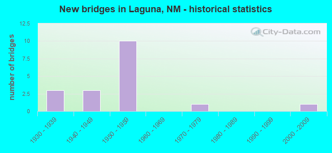
- New bridges - historical statistics
- 31930-1939
- 31940-1949
- 101950-1959
- 11970-1979
- 12000-2009

- Reconstructed bridges - Historical Statistics
- 11960-1969
- 11970-1979
- 11980-1989
- 11990-1999
- 12000-2009


- Bridge Condition - Deck
- 16.7%Good
- 33.3%Satisfactory
- 50.0%Fair

- Bridge Condition - Superstructure
- 16.7%Good
- 16.7%Satisfactory
- 50.0%Fair
- 16.7%Serious

- Bridge Condition - Substructure
- 33.3%Good
- 50.0%Fair
- 16.7%Poor

- Bridge Condition - Channel
- 64.7%Good
- 35.3%Satisfactory

- Bridge Condition - Culverts
- 25.0%Good
- 50.0%Satisfactory
- 8.3%Fair
- 16.7%Poor
Find on map >> Show street view
Structure Number: 3088, Location: 2.5 MI W OF I-40/LAGUNA (Lat: 35.047047, Lng: -107.408806), Route carried "on" structure: State highway 124, Year Built: 1936, Status: Open, Structure Length: 0.79m (2.59ft), Average Daily Traffic: 1,071 (year 2020), Truck Traffic: 21%, Average Future Daily Traffic: 921 (year 2040), Design Load: H 15, Features Intersected: UNNAMED WATERWAY
Minimum Vertical Clearance: 30+ m (98+ ft), Kilometerpoint: 36.934, Lanes on structure: 2, Owner: State Highway Agency, Approaching Roadway Width: 7.6m (24.9ft), Material/Design: Concrete continuous, Design/Construction: Culvert, Number Of Spans In Main Unit: 4, Length of Maximum Span: 1.8m (5.9ft)
Condition: Channel: Good, Culverts: Poor, Operating Rating: 34.0 metric tons, Method Used To Determine Operating Rating: Load Factor (LF), Inventory Rating: 24.3 metric tons, Method Used To Determine Inventory Rating: Load Factor (LF), Structural Evaluation: Meets minimum limits, Waterway Adequacy: Equal to present desirable criteria, Approach Roadway Alignment: Equal to present desirable criteria, Length Of Structure Improvement: 0.79m (2.59ft), Designated Inspection Frequency: Every 12 months, Inspection Date: October 2021, Bridge Improvement Cost: $37,000, Roadway Improvement Cost: $3,000, Total Project Cost: $56,000 ( Estimate for 2020)
Find on map >> Show street view
Structure Number: 3089, Location: 15.5M E NM124-I40/LAGUNA (Lat: 35.046825, Lng: -107.411300), Route carried "on" structure: State highway 124, Year Built: 1936, Status: Open, Structure Length: 0.78m (2.56ft), Average Daily Traffic: 1,071 (year 2020), Truck Traffic: 21%, Average Future Daily Traffic: 921 (year 2040), Design Load: H 15, Features Intersected: UNNAMED WATERWAY
Minimum Vertical Clearance: 30+ m (98+ ft), Kilometerpoint: 36.731, Lanes on structure: 2, Owner: State Highway Agency, Approaching Roadway Width: 7.8m (25.6ft), Material/Design: Concrete continuous, Design/Construction: Culvert, Number Of Spans In Main Unit: 4, Length of Maximum Span: 1.8m (5.9ft)
Condition: Channel: Good, Culverts: Poor, Operating Rating: 34.0 metric tons, Method Used To Determine Operating Rating: Load Factor (LF), Inventory Rating: 24.3 metric tons, Method Used To Determine Inventory Rating: Load Factor (LF), Structural Evaluation: Meets minimum limits, Waterway Adequacy: Equal to present desirable criteria, Approach Roadway Alignment: Equal to present desirable criteria, Length Of Structure Improvement: 0.79m (2.59ft), Designated Inspection Frequency: Every 24 months, Inspection Date: October 2021, Bridge Improvement Cost: $39,000, Roadway Improvement Cost: $3,000, Total Project Cost: $59,000 ( Estimate for 2020)
Find on map >> Show street view
Structure Number: 3303, Location: 9.2 MI N OF JCT US-60 (Lat: 34.550147, Lng: -106.755514), Route carried "on" structure: State highway 304, Year Built: 1973, Status: Open, Structure Length: 0.98m (3.22ft), Average Daily Traffic: 3,126 (year 2020), Truck Traffic: 21%, Average Future Daily Traffic: 2,686 (year 2040), Features Intersected: SAN JUAN CANAL
Minimum Vertical Clearance: 30+ m (98+ ft), Kilometerpoint: 25.669, Lanes on structure: 2, Owner: State Highway Agency, Approaching Roadway Width: 6.7m (22.0ft), Material/Design: Wood or Timber, Design/Construction: Stringer/Multi-beam, Number Of Spans In Main Unit: 1, Length of Maximum Span: 9.8m (32.2ft), Curb-To-Curb Width: 10.1m (33.1ft), Out-to-Out Width: 10.2m (33.5ft)
Condition: Deck: Fair, Superstructure: Fair, Substructure: Fair, Channel: Good, Operating Rating: 38.9 metric tons, Method Used To Determine Operating Rating: Allowable Stress (AS), Inventory Rating: 27.5 metric tons, Method Used To Determine Inventory Rating: Allowable Stress (AS), Structural Evaluation: Somewhat better than minimum adequacy, Deck Geometry: Meets minimum limits, Waterway Adequacy: Superior to present desirable criteria, Approach Roadway Alignment: Equal to present desirable criteria, Length Of Structure Improvement: 0.98m (3.22ft), Designated Inspection Frequency: Every 18 months, Inspection Date: September 2021, Bridge Improvement Cost: $180,000, Roadway Improvement Cost: $138,000, Total Project Cost: $390,000 ( Estimate for 2030), Deck Structure Type: Wood or Timber, Wearing Surface/Protective System: Wearing Surface: Bituminous
Find on map >> Show street view
Structure Number: 4295, Location: 29.8 MI E OF ARIZ ST LINE (Lat: 34.326767, Lng: -108.571956), Route carried "on" structure: US 60, Year Built: 1941, Year Reconstructed: 1991, Status: Open, Structure Length: 0.62m (2.03ft), Average Daily Traffic: 488 (year 2020), Truck Traffic: 16%, Average Future Daily Traffic: 377 (year 2040), Design Load: H 15, Features Intersected: ARMSTRONG CANYON
Minimum Vertical Clearance: 30+ m (98+ ft), Kilometerpoint: 47.898, Lanes on structure: 2, Base Highway Network: Yes, Owner: State Highway Agency, Approaching Roadway Width: 13.1m (43.0ft), Skew: 4 degrees, Material/Design: Concrete continuous, Design/Construction: Culvert, Number Of Spans In Main Unit: 2, Length of Maximum Span: 2.1m (6.9ft)
Condition: Channel: Good, Culverts: Satisfactory, Operating Rating: 38.9 metric tons, Method Used To Determine Operating Rating: Load Factor (LF), Inventory Rating: 24.3 metric tons, Method Used To Determine Inventory Rating: Load Factor (LF), Structural Evaluation: Equal to present minimum criteria, Waterway Adequacy: Equal to present desirable criteria, Approach Roadway Alignment: Equal to present desirable criteria, Length Of Structure Improvement: 0.67m (2.20ft), Designated Inspection Frequency: Every 48 months, Inspection Date: January 2021, Bridge Improvement Cost: $134,000, Roadway Improvement Cost: $13,000, Total Project Cost: $202,000 ( Estimate for 2020)
Find on map >> Show street view
Structure Number: 5354, Location: 38.4 MI E OF JCT NM-36 (Lat: 34.185200, Lng: -107.894283), Route carried "on" structure: US 60, Year Built: 1941, Year Reconstructed: 1997, Status: Open, Structure Length: 0.86m (2.82ft), Average Daily Traffic: 335 (year 2020), Truck Traffic: 16%, Average Future Daily Traffic: 258 (year 2040), Design Load: H 15, Features Intersected: SWINGLE CANYON
Minimum Vertical Clearance: 30+ m (98+ ft), Kilometerpoint: 118.014, Lanes on structure: 2, Base Highway Network: Yes, Owner: State Highway Agency, Approaching Roadway Width: 14.3m (46.9ft), Skew: 4 degrees, Material/Design: Concrete continuous, Design/Construction: Culvert, Number Of Spans In Main Unit: 2, Length of Maximum Span: 3.0m (9.8ft)
Condition: Channel: Good, Culverts: Good, Operating Rating: 40.5 metric tons, Method Used To Determine Operating Rating: Load Factor (LF), Inventory Rating: 24.3 metric tons, Method Used To Determine Inventory Rating: Load Factor (LF), Structural Evaluation: Equal to present minimum criteria, Waterway Adequacy: Equal to present desirable criteria, Approach Roadway Alignment: Equal to present desirable criteria, Length Of Structure Improvement: 0.85m (2.79ft), Designated Inspection Frequency: Every 48 months, Inspection Date: March 2019, Bridge Improvement Cost: $133,000, Roadway Improvement Cost: $13,000, Total Project Cost: $199,000 ( Estimate for 2020)
Find on map >> Show street view
Structure Number: 5475, Location: 0.5 MI W OF EXIT-114 (Lat: 35.038247, Lng: -107.379950), Route carried "on" structure: State highway 124, Year Built: 1955, Status: Open, Structure Length: 3.93m (12.89ft), Average Daily Traffic: 1,946 (year 2020), Truck Traffic: 15%, Average Future Daily Traffic: 307 (year 2040), Design Load: HS 20, Features Intersected: RIO SAN JOSE
Minimum Vertical Clearance: 30+ m (98+ ft), Kilometerpoint: 39.928, Lanes on structure: 2, Owner: State Highway Agency, Approaching Roadway Width: 8.8m (28.9ft), Skew: 10 degrees, Material/Design: Steel continuous, Design/Construction: Stringer/Multi-beam, Number Of Spans In Main Unit: 3, Length of Maximum Span: 14.9m (48.9ft), Curb or Sidewalk Widths: Left: 0.5m (1.6ft), Right: 0.5m (1.6ft), Curb-To-Curb Width: 8.7m (28.5ft), Out-to-Out Width: 9.7m (31.8ft)
Condition: Deck: Satisfactory, Superstructure: Fair, Substructure: Fair, Channel: Satisfactory, Operating Rating: 58.3 metric tons, Method Used To Determine Operating Rating: Load Factor (LF), Inventory Rating: 32.4 metric tons, Method Used To Determine Inventory Rating: Load Factor (LF), Structural Evaluation: Somewhat better than minimum adequacy, Deck Geometry: High priority of corrective action, Waterway Adequacy: Equal to present desirable criteria, Approach Roadway Alignment: Equal to present desirable criteria, Length Of Structure Improvement: 3.93m (12.89ft), Designated Inspection Frequency: Every 24 months, Inspection Date: May 2021, Bridge Improvement Cost: $170,000, Roadway Improvement Cost: $92,000, Total Project Cost: $330,000 ( Estimate for 2020), Deck Structure Type: Concrete Cast-file-Place
Find on map >> Show street view
Structure Number: 5476, Location: 0.5 MI W OF EXIT-114 (Lat: 35.038100, Lng: -107.379992), Route carried "on" structure: State highway 124, Year Built: 1955, Status: Open, Structure Length: 3.93m (12.89ft), Average Daily Traffic: 1,946 (year 2020), Truck Traffic: 15%, Average Future Daily Traffic: 307 (year 2040), Design Load: HS 20, Features Intersected: RIO SAN JOSE
Minimum Vertical Clearance: 30+ m (98+ ft), Kilometerpoint: 39.928, Lanes on structure: 2, Owner: State Highway Agency, Approaching Roadway Width: 7.6m (24.9ft), Skew: 10 degrees, Material/Design: Steel continuous, Design/Construction: Stringer/Multi-beam, Number Of Spans In Main Unit: 3, Length of Maximum Span: 14.9m (48.9ft), Curb or Sidewalk Widths: Left: 0.5m (1.6ft), Right: 0.5m (1.6ft), Curb-To-Curb Width: 8.7m (28.5ft), Out-to-Out Width: 9.7m (31.8ft)
Condition: Deck: Fair, Superstructure: Fair, Substructure: Fair, Channel: Good, Operating Rating: 58.3 metric tons, Method Used To Determine Operating Rating: Load Factor (LF), Inventory Rating: 32.4 metric tons, Method Used To Determine Inventory Rating: Load Factor (LF), Structural Evaluation: Somewhat better than minimum adequacy, Deck Geometry: High priority of corrective action, Waterway Adequacy: Equal to present desirable criteria, Approach Roadway Alignment: Equal to present desirable criteria, Length Of Structure Improvement: 3.93m (12.89ft), Designated Inspection Frequency: Every 24 months, Inspection Date: October 2020, Bridge Improvement Cost: $170,000, Roadway Improvement Cost: $92,000, Total Project Cost: $330,000 ( Estimate for 2020), Deck Structure Type: Concrete Cast-file-Place
Find on map >> Show street view
Structure Number: 5477, Location: 0.1 MI E OF NM-279 (Lat: 35.045203, Lng: -107.393056), Route carried "on" structure: State highway 124, Year Built: 1955, Year Reconstructed: 2007, Status: Open, Structure Length: 5.43m (17.81ft), Average Daily Traffic: 1,946 (year 2020), Truck Traffic: 15%, Average Future Daily Traffic: 307 (year 2040), Design Load: HS 20, Features Intersected: BNSF RAILROAD
Minimum Vertical Clearance: 30+ m (98+ ft), Kilometerpoint: 38.431, Lanes on structure: 4, Lanes under structure: 2, Owner: State Highway Agency, Approaching Roadway Width: 15.9m (52.2ft), Skew: 4 degrees, Material/Design: Steel continuous, Design/Construction: Stringer/Multi-beam, Number Of Spans In Main Unit: 3, Length of Maximum Span: 20.4m (66.9ft), Curb-To-Curb Width: 18.9m (62.0ft), Out-to-Out Width: 20.0m (65.6ft)
Condition: Deck: Good, Superstructure: Good, Substructure: Good, Operating Rating: 53.4 metric tons, Method Used To Determine Operating Rating: Load Factor (LF), Inventory Rating: 31.9 metric tons, Method Used To Determine Inventory Rating: Load Factor (LF), Structural Evaluation: Better than present minimum criteria, Deck Geometry: Equal to present minimum criteria, Underclear: Better than present minimum criteria, Approach Roadway Alignment: Equal to present desirable criteria, Length Of Structure Improvement: 5.43m (17.81ft), Designated Inspection Frequency: Every 24 months, Inspection Date: January 2022, Bridge Improvement Cost: $420,000, Roadway Improvement Cost: $82,000, Total Project Cost: $670,000 ( Estimate for 2020), Deck Structure Type: Concrete Cast-file-Place, Wearing Surface/Protective System: Deck Protection: Epoxy Coated Reinforcing
Find on map >> Show street view
Structure Number: 5603, Location: 7.20 MI S OF NM-337 (Lat: 34.694567, Lng: -106.303242), Route carried "on" structure: State highway 55, Year Built: 1948, Status: Open, Structure Length: 1.87m (6.14ft), Average Daily Traffic: 626 (year 2020), Truck Traffic: 21%, Average Future Daily Traffic: 538 (year 2040), Design Load: HS 20, Features Intersected: UNNAMED WATERWAY
Minimum Vertical Clearance: 30+ m (98+ ft), Kilometerpoint: 127.782, Lanes on structure: 2, Owner: State Highway Agency, Approaching Roadway Width: 6.6m (21.7ft), Material/Design: Concrete continuous, Design/Construction: Culvert, Number Of Spans In Main Unit: 7, Length of Maximum Span: 2.4m (7.9ft)
Condition: Channel: Good, Culverts: Good, Operating Rating: 50.2 metric tons, Method Used To Determine Operating Rating: Load Factor (LF), Inventory Rating: 32.4 metric tons, Method Used To Determine Inventory Rating: Load Factor (LF), Structural Evaluation: Better than present minimum criteria, Waterway Adequacy: Equal to present desirable criteria, Approach Roadway Alignment: Equal to present desirable criteria, Designated Inspection Frequency: Every 48 months, Inspection Date: November 2020
Find on map >> Show street view
Structure Number: 5654, Location: 5.3 MI N OF NM-445/HOXIE (Lat: 36.772050, Lng: -104.480958), Route carried "on" structure: US 64, Year Built: 1951, Status: Open, Structure Length: 1.07m (3.51ft), Average Daily Traffic: 569 (year 2020), Truck Traffic: 16%, Average Future Daily Traffic: 914 (year 2040), Design Load: H 20, Features Intersected: UNNAMED WATERWAY
Minimum Vertical Clearance: 30+ m (98+ ft), Kilometerpoint: 547.528, Lanes on structure: 2, Base Highway Network: Yes, Owner: State Highway Agency, Approaching Roadway Width: 12.2m (40.0ft), Material/Design: Concrete continuous, Design/Construction: Culvert, Number Of Spans In Main Unit: 4, Length of Maximum Span: 2.4m (7.9ft)
Condition: Channel: Satisfactory, Culverts: Good, Operating Rating: 53.5 metric tons, Method Used To Determine Operating Rating: Load Factor (LF), Inventory Rating: 24.3 metric tons, Method Used To Determine Inventory Rating: Load Factor (LF), Structural Evaluation: Equal to present minimum criteria, Waterway Adequacy: Equal to present desirable criteria, Approach Roadway Alignment: Equal to present desirable criteria, Designated Inspection Frequency: Every 48 months, Inspection Date: April 2018
Find on map >> Show street view
Structure Number: 5762, Location: 6.7 MI N OF JCT US-550 (Lat: 35.387947, Lng: -106.457419), Route carried "on" structure: Interstate 25, Year Built: 1955, Year Reconstructed: 1983, Status: Open, Structure Length: 1.37m (4.49ft), Average Daily Traffic: 26,720 (year 2020), Truck Traffic: 37%, Average Future Daily Traffic: 45,742 (year 2040), Design Load: HS 20, Features Intersected: N BRANCH MARIA CHAVEZ AR
Minimum Vertical Clearance: 30+ m (98+ ft), Kilometerpoint: 400.534, Lanes on structure: 4, Base Highway Network: Yes, Owner: State Highway Agency, Approaching Roadway Width: 29.3m (96.1ft), Skew: 14 degrees, Material/Design: Concrete continuous, Design/Construction: Culvert, Number Of Spans In Main Unit: 4, Length of Maximum Span: 3.0m (9.8ft)
Condition: Channel: Satisfactory, Culverts: Satisfactory, Operating Rating: 89.1 metric tons, Method Used To Determine Operating Rating: Load Factor (LF), Inventory Rating: 32.4 metric tons, Method Used To Determine Inventory Rating: Load Factor (LF), Structural Evaluation: Equal to present minimum criteria, Waterway Adequacy: Equal to present desirable criteria, Approach Roadway Alignment: Equal to present desirable criteria, Designated Inspection Frequency: Every 24 months, Inspection Date: September 2021
Find on map >> Show street view
Structure Number: 5921, Location: JCT NM-519 @ LA MADERA (Lat: 36.390375, Lng: -106.041992), Route carried "on" structure: State highway 111, Year Built: 1957, Status: Open, Structure Length: 1.30m (4.27ft), Average Daily Traffic: 342 (year 2020), Truck Traffic: 20%, Average Future Daily Traffic: 294 (year 2040), Design Load: HS 20, Features Intersected: UNNAMED WATERWAY
Minimum Vertical Clearance: 30+ m (98+ ft), Kilometerpoint: 7.886, Lanes on structure: 2, Owner: State Highway Agency, Approaching Roadway Width: 7.0m (23.0ft), Material/Design: Concrete continuous, Design/Construction: Culvert, Number Of Spans In Main Unit: 4, Length of Maximum Span: 3.0m (9.8ft)
Condition: Channel: Good, Culverts: Satisfactory, Operating Rating: 53.5 metric tons, Method Used To Determine Operating Rating: Load Factor (LF), Inventory Rating: 32.4 metric tons, Method Used To Determine Inventory Rating: Load Factor (LF), Structural Evaluation: Equal to present minimum criteria, Waterway Adequacy: Equal to present desirable criteria, Approach Roadway Alignment: Equal to present minimum criteria, Designated Inspection Frequency: Every 48 months, Inspection Date: April 2018
Find on map >> Show street view
Structure Number: 5922, Location: 1.4 MI N OF JCT NM-519 (Lat: 36.400244, Lng: -106.051378), Route carried "on" structure: State highway 111, Year Built: 1957, Status: Open, Structure Length: 2.28m (7.48ft), Average Daily Traffic: 342 (year 2020), Truck Traffic: 20%, Average Future Daily Traffic: 294 (year 2040), Features Intersected: UNNAMED WATERWAY
Minimum Vertical Clearance: 30+ m (98+ ft), Kilometerpoint: 10.139, Lanes on structure: 2, Owner: State Highway Agency, Approaching Roadway Width: 6.4m (21.0ft), Skew: 3 degrees, Material/Design: Concrete continuous, Design/Construction: Culvert, Number Of Spans In Main Unit: 5, Length of Maximum Span: 3.0m (9.8ft)
Condition: Channel: Satisfactory, Culverts: Satisfactory, Operating Rating: 53.5 metric tons, Method Used To Determine Operating Rating: Load Factor (LF), Inventory Rating: 32.4 metric tons, Method Used To Determine Inventory Rating: Load Factor (LF), Structural Evaluation: Equal to present minimum criteria, Waterway Adequacy: Better than present minimum criteria, Approach Roadway Alignment: Equal to present minimum criteria, Designated Inspection Frequency: Every 48 months, Inspection Date: April 2018
Find on map >> Show street view
Structure Number: 5995, Location: 2.0 MI E OF JCT NM-129 (Lat: 35.329094, Lng: -104.226697), Route carried "on" structure: State highway 104, Year Built: 1959, Status: Open, Structure Length: 5.70m (18.70ft), Average Daily Traffic: 123 (year 2020), Truck Traffic: 20%, Average Future Daily Traffic: 106 (year 2040), Design Load: HS 20, Features Intersected: UNNAMED WATERWAY
Minimum Vertical Clearance: 30+ m (98+ ft), Kilometerpoint: 114.746, Lanes on structure: 2, Owner: State Highway Agency, Approaching Roadway Width: 7.3m (24.0ft), Material/Design: Concrete, Design/Construction: Channel Beam, Number Of Spans In Main Unit: 6, Length of Maximum Span: 9.4m (30.8ft), Curb-To-Curb Width: 8.7m (28.5ft), Out-to-Out Width: 9.3m (30.5ft)
Condition: Deck: Fair, Superstructure: Serious, Substructure: Poor, Channel: Satisfactory, Operating Rating: 45.6 metric tons, Method Used To Determine Operating Rating: Load Factor (LF), Inventory Rating: 27.3 metric tons, Method Used To Determine Inventory Rating: Load Factor (LF), Structural Evaluation: High priority of corrective action, Deck Geometry: Equal to present minimum criteria, Waterway Adequacy: Equal to present desirable criteria, Approach Roadway Alignment: Equal to present desirable criteria, Length Of Structure Improvement: 5.73m (18.80ft), Designated Inspection Frequency: Every 12 months, Inspection Date: Febuary 2022, Bridge Improvement Cost: $430,000, Roadway Improvement Cost: $108,000, Total Project Cost: $710,000 ( Estimate for 2030), Deck Structure Type: Concrete Precast Panels, Wearing Surface/Protective System: Wearing Surface: Bituminous
Find on map >> Show street view
Structure Number: 6008, Location: 22.7 MI E OF JCT US-491 (Lat: 35.447028, Lng: -108.365606), Route carried "on" structure: Interstate 40, Year Built: 1957, Year Reconstructed: 1966, Status: Open, Structure Length: 1.31m (4.30ft), Average Daily Traffic: 20,726 (year 2020), Truck Traffic: 37%, Average Future Daily Traffic: 35,481 (year 2040), Design Load: HS 20, Features Intersected: FOSTER CANYON
Minimum Vertical Clearance: 30+ m (98+ ft), Kilometerpoint: 71.691, Lanes on structure: 4, Base Highway Network: Yes, Owner: State Highway Agency, Approaching Roadway Width: 23.8m (78.1ft), Skew: 20 degrees, Material/Design: Concrete continuous, Design/Construction: Culvert, Number Of Spans In Main Unit: 4, Length of Maximum Span: 3.0m (9.8ft)
Condition: Channel: Good, Culverts: Satisfactory, Operating Rating: 87.5 metric tons, Method Used To Determine Operating Rating: Load Factor (LF), Inventory Rating: 32.4 metric tons, Method Used To Determine Inventory Rating: Load Factor (LF), Structural Evaluation: Equal to present minimum criteria, Waterway Adequacy: Equal to present desirable criteria, Approach Roadway Alignment: Equal to present desirable criteria, Length Of Structure Improvement: 1.31m (4.30ft), Designated Inspection Frequency: Every 48 months, Inspection Date: July 2020, Bridge Improvement Cost: $550,000, Roadway Improvement Cost: $55,000, Total Project Cost: $825,000 ( Estimate for 2020)
Find on map >> Show street view
Structure Number: 6046, Location: 3.84 MI S OF US-60 (Lat: 34.404928, Lng: -104.197664), Route carried "on" structure: State highway 212, Year Built: 1935, Status: Open, Structure Length: 1.01m (3.31ft), Average Daily Traffic: 108 (year 2020), Truck Traffic: 16%, Average Future Daily Traffic: 201 (year 2040), Design Load: H 15, Features Intersected: IRRIGATION CANAL
Minimum Vertical Clearance: 30+ m (98+ ft), Kilometerpoint: 0.386, Lanes on structure: 2, Owner: State Highway Agency, Approaching Roadway Width: 7.3m (24.0ft), Material/Design: Wood or Timber, Design/Construction: Stringer/Multi-beam, Number Of Spans In Main Unit: 1, Length of Maximum Span: 9.4m (30.8ft), Curb-To-Curb Width: 5.4m (17.7ft), Out-to-Out Width: 5.5m (18.0ft)
Condition: Deck: Satisfactory, Superstructure: Satisfactory, Substructure: Good, Channel: Good, Operating Rating: 29.2 metric tons, Method Used To Determine Operating Rating: Allowable Stress (AS), Inventory Rating: 21.1 metric tons, Method Used To Determine Inventory Rating: Allowable Stress (AS), Structural Evaluation: Equal to present minimum criteria, Waterway Adequacy: Equal to present desirable criteria, Approach Roadway Alignment: Equal to present minimum criteria, Length Of Structure Improvement: 1.01m (3.31ft), Designated Inspection Frequency: Every 24 months, Inspection Date: June 2020, Bridge Improvement Cost: $160,000, Roadway Improvement Cost: $116,000, Total Project Cost: $340,000, Deck Structure Type: Wood or Timber, Wearing Surface/Protective System: Wearing Surface: Bituminous
Find on map >> Show street view
Structure Number: 6151, Location: 0.1 MI W JCT NM 107/US 60 (Lat: 34.111714, Lng: -107.257903), Route carried "on" structure: US 60, Year Built: 1958, Status: Open, Structure Length: 0.63m (2.07ft), Average Daily Traffic: 655 (year 2020), Truck Traffic: 16%, Average Future Daily Traffic: 505 (year 2040), Design Load: HS 20, Features Intersected: UNNAMED WATERWAY
Minimum Vertical Clearance: 30+ m (98+ ft), Kilometerpoint: 179.764, Lanes on structure: 2, Base Highway Network: Yes, Owner: State Highway Agency, Approaching Roadway Width: 13.4m (44.0ft), Material/Design: Concrete continuous, Design/Construction: Culvert, Number Of Spans In Main Unit: 2, Length of Maximum Span: 3.0m (9.8ft), Out-to-Out Width: 14.2m (46.6ft)
Condition: Channel: Good, Culverts: Satisfactory, Operating Rating: 57.2 metric tons, Method Used To Determine Operating Rating: Load Factor (LF), Inventory Rating: 32.7 metric tons, Method Used To Determine Inventory Rating: Load Factor (LF), Structural Evaluation: Equal to present minimum criteria, Waterway Adequacy: Equal to present desirable criteria, Approach Roadway Alignment: Equal to present desirable criteria, Designated Inspection Frequency: Every 24 months, Inspection Date: Febuary 2021
Find on map >> Show street view
Structure Number: M15, Location: 7.2 KM S OF CASA BLANCA (Lat: 34.991350, Lng: -107.485447), Route carried "on" structure: Federal lands road L22, Year Built: 2000, Status: Open, Structure Length: 1.26m (4.13ft), Average Daily Traffic: 300 (year 2021), Truck Traffic: 10%, Average Future Daily Traffic: 351 (year 2041), Design Load: HS 25 or greater, Features Intersected: ACOMA WASH
Minimum Vertical Clearance: 30+ m (98+ ft), Kilometerpoint: 14.000, Lanes on structure: 2, Owner: Bureau of Indian Affairs, Approaching Roadway Width: 9.7m (31.8ft), Skew: 2 degrees, Material/Design: Steel, Design/Construction: Culvert, Number Of Spans In Main Unit: 4, Length of Maximum Span: 2.4m (7.9ft), Curb-To-Curb Width: 9.3m (30.5ft), Out-to-Out Width: 9.3m (30.5ft)
Condition: Channel: Satisfactory, Culverts: Fair, Operating Rating: 54.4 metric tons, Method Used To Determine Operating Rating: No rating analysis performed, Inventory Rating: 40.8 metric tons, Method Used To Determine Inventory Rating: No rating analysis performed, Structural Evaluation: Somewhat better than minimum adequacy, Deck Geometry: Equal to present minimum criteria, Waterway Adequacy: Equal to present desirable criteria, Approach Roadway Alignment: Equal to present desirable criteria, Designated Inspection Frequency: Every 24 months, Inspection Date: April 2021, Deck Structure Type: Other