Bridge Statistics for Lake Andes, South Dakota (SD)
Condition, Traffic, Stress, Structural Evaluation, Project Costs
- National Bridge Inventory (NBI) Statistics
- 10Number of bridges
- 33ft / 9.8mTotal length
- $2,620,000Total costs
- 3,824Total average daily traffic
- 469Total average daily truck traffic
- 5,401Total future (year 2032) average daily traffic
- National Bridge Inventory (NBI) Registered Bridges for Lake Andes
- No street view available for this location
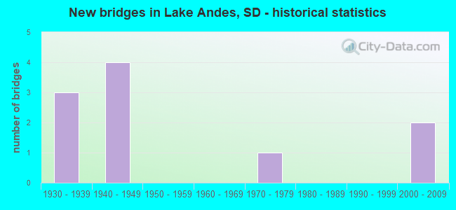
- New bridges - historical statistics
- 31930-1939
- 41940-1949
- 11970-1979
- 22000-2009

- Bridge Condition - Deck
- 40.0%Satisfactory
- 60.0%Fair

- Bridge Condition - Superstructure
- 40.0%Satisfactory
- 40.0%Fair
- 20.0%Poor

- Bridge Condition - Substructure
- 20.0%Satisfactory
- 20.0%Poor
- 40.0%Serious
- 20.0%Critical

- Bridge Condition - Channel
- 40.0%Very good
- 20.0%Satisfactory
- 40.0%Fair

- Bridge Condition - Culverts
- 60.0%Very good
- 20.0%Poor
- 20.0%Serious
Find on map >> Show street view
Structure Number: 1236823, Location: 1.0N & 1.2W of Lake Andes (Lat: 43.169919, Lng: -98.570875), Route carried "on" structure: Other road , Year Built: 1935, Status: Posted for load, Structure Length: 0.98m (3.22ft), Average Daily Traffic: 48 (year 2019), Truck Traffic: 2%, Average Future Daily Traffic: 48 (year 2032), Features Intersected: Creek, Facility Carried by Structure: 38080 291st Street
Minimum Vertical Clearance: 30+ m (98+ ft), Kilometerpoint: 0.000, Lanes on structure: 2, Owner: County Highway Agency, Approaching Roadway Width: 6.1m (20.0ft), Skew: 3 degrees, Material/Design: Steel, Design/Construction: Stringer/Multi-beam, Number Of Spans In Main Unit: 1, Length of Maximum Span: 9.1m (29.9ft), Curb-To-Curb Width: 5.0m (16.4ft), Out-to-Out Width: 5.3m (17.4ft)
Condition: Deck: Fair, Superstructure: Fair, Substructure: Serious, Channel: Fair, Operating Rating: 24.5 metric tons, Method Used To Determine Operating Rating: Field evaluation and documented engineering judgment, Inventory Rating: 18.3 metric tons, Method Used To Determine Inventory Rating: Field evaluation and documented engineering judgment, Structural Evaluation: High priority of corrective action, Deck Geometry: High priority of corrective action, Waterway Adequacy: Equal to present minimum criteria, Approach Roadway Alignment: Meets minimum limits, Bridge Posting: Required (Relationship of Operating Rating to Maximum Legal Load: 20.0 - 29.9% below), Length Of Structure Improvement: 1.07m (3.51ft), Designated Inspection Frequency: Every 24 months, Inspection Date: August 2021, Bridge Improvement Cost: $530,000, Roadway Improvement Cost: $30,000, Total Project Cost: $560,000 ( Estimate for 2019), Deck Structure Type: Concrete Cast-file-Place, Wearing Surface/Protective System: Wearing Surface: Gravel
Find on map >> Show street view
Structure Number: 12370267, Location: 2.7S & 1.0W of Lake Andes (Lat: 43.116314, Lng: -98.566075), Route carried "on" structure: Other road , Year Built: 1979, Status: Posted for load, Structure Length: 1.55m (5.09ft), Average Daily Traffic: 48 (year 2019), Truck Traffic: 2%, Average Future Daily Traffic: 48 (year 2032), Features Intersected: Creek, Facility Carried by Structure: 29470 381st Avenue
Minimum Vertical Clearance: 30+ m (98+ ft), Kilometerpoint: 0.000, Lanes on structure: 2, Owner: County Highway Agency, Approaching Roadway Width: 4.9m (16.1ft), Material/Design: Prestressed concrete, Design/Construction: Tee Beam, Number Of Spans In Main Unit: 1, Length of Maximum Span: 14.9m (48.9ft), Curb-To-Curb Width: 6.0m (19.7ft), Out-to-Out Width: 6.1m (20.0ft)
Condition: Deck: Satisfactory, Superstructure: Satisfactory, Substructure: Serious, Channel: Fair, Operating Rating: 24.5 metric tons, Method Used To Determine Operating Rating: Field evaluation and documented engineering judgment, Inventory Rating: 18.4 metric tons, Method Used To Determine Inventory Rating: Field evaluation and documented engineering judgment, Structural Evaluation: High priority of corrective action, Deck Geometry: Meets minimum limits, Waterway Adequacy: Equal to present desirable criteria, Approach Roadway Alignment: Better than present minimum criteria, Bridge Posting: Required (Relationship of Operating Rating to Maximum Legal Load: 20.0 - 29.9% below), Length Of Structure Improvement: 1.68m (5.51ft), Designated Inspection Frequency: Every 24 months, Inspection Date: August 2021, Bridge Improvement Cost: $604,000, Roadway Improvement Cost: $30,000, Total Project Cost: $634,000 ( Estimate for 2019), Deck Structure Type: Concrete Precast Panels, Wearing Surface/Protective System: Wearing Surface: Gravel
Find on map >> Show street view
Structure Number: 1237426, Location: 1.5W & 2.9S Lake Andes (Lat: 43.126269, Lng: -98.556239), Route carried "on" structure: County highway , Year Built: 1940, Status: Posted for load, Structure Length: 0.99m (3.25ft), Average Daily Traffic: 20 (year 2020), Average Future Daily Traffic: 20 (year 2040), Design Load: HS 20, Features Intersected: Garden Ck, Facility Carried by Structure: 294th Street
Minimum Vertical Clearance: 30+ m (98+ ft), Kilometerpoint: 0.000, Lanes on structure: 2, Owner: County Highway Agency, Approaching Roadway Width: 3.0m (9.8ft), Material/Design: Steel, Design/Construction: Stringer/Multi-beam, Number Of Spans In Main Unit: 1, Length of Maximum Span: 9.8m (32.2ft), Curb-To-Curb Width: 5.0m (16.4ft), Out-to-Out Width: 5.0m (16.4ft)
Condition: Deck: Satisfactory, Superstructure: Satisfactory, Substructure: Poor, Channel: Fair, Operating Rating: 8.8 metric tons, Method Used To Determine Operating Rating: Load Factor (LF), Inventory Rating: 5.3 metric tons, Method Used To Determine Inventory Rating: Load Factor (LF), Structural Evaluation: High priority of corrective action, Deck Geometry: High priority of corrective action, Waterway Adequacy: Equal to present minimum criteria, Approach Roadway Alignment: Somewhat better than minimum adequacy, Bridge Posting: Required (Relationship of Operating Rating to Maximum Legal Load: > 39.9% below), Designated Inspection Frequency: Every 24 months, Inspection Date: December 2021, Deck Structure Type: Wood or Timber, Wearing Surface/Protective System: Wearing Surface: Wood or Timber
Find on map >> Show street view
Structure Number: 1237624, Location: 0.8 W JCT US 18 & 281 (Lat: 43.155311, Lng: -98.554067), Route carried "on" structure: State highway 50, Year Built: 1941, Status: Open, Structure Length: 0.63m (2.07ft), Average Daily Traffic: 548 (year 2021), Truck Traffic: 9%, Average Future Daily Traffic: 791 (year 2041), Design Load: H 15, Features Intersected: GARDEN CK
Minimum Vertical Clearance: 30+ m (98+ ft), Kilometerpoint: 504.240, Lanes on structure: 2, Base Highway Network: Yes, Owner: State Highway Agency, Approaching Roadway Width: 9.1m (29.9ft), Material/Design: Concrete continuous, Design/Construction: Culvert, Number Of Spans In Main Unit: 2, Length of Maximum Span: 3.0m (9.8ft)
Condition: Channel: Very good, Culverts: Very good, Operating Rating: 32.7 metric tons, Method Used To Determine Operating Rating: Field evaluation and documented engineering judgment, Inventory Rating: 25.1 metric tons, Method Used To Determine Inventory Rating: Field evaluation and documented engineering judgment, Structural Evaluation: Equal to present minimum criteria, Waterway Adequacy: Equal to present desirable criteria, Approach Roadway Alignment: Equal to present desirable criteria, Length Of Structure Improvement: 0.64m (2.10ft), Designated Inspection Frequency: Every 24 months, Inspection Date: June 2020, Bridge Improvement Cost: $10,000, Roadway Improvement Cost: $1,000, Total Project Cost: $12,000
Find on map >> Show street view
Structure Number: 12389243, Location: 0.6 E JCT SD 50 W (Lat: 43.150667, Lng: -98.526933), Route carried "on" structure: US 18, Year Built: 2005, Status: Open, Structure Length: 0.63m (2.07ft), Average Daily Traffic: 1,506 (year 2021), Truck Traffic: 14%, Average Future Daily Traffic: 2,173 (year 2041), Design Load: HS 20+Mod, Features Intersected: LAKE ANDES OUTLET
Minimum Vertical Clearance: 30+ m (98+ ft), Kilometerpoint: 546.662, Lanes on structure: 2, Owner: State Highway Agency, Approaching Roadway Width: 13.4m (44.0ft), Material/Design: Concrete continuous, Design/Construction: Culvert, Number Of Spans In Main Unit: 2, Length of Maximum Span: 3.0m (9.8ft)
Condition: Channel: Very good, Culverts: Very good, Operating Rating: 89.8 metric tons, Method Used To Determine Operating Rating: Load Factor (LF), Inventory Rating: 62.2 metric tons, Method Used To Determine Inventory Rating: Load Factor (LF), Structural Evaluation: Equal to present desirable criteria, Waterway Adequacy: Superior to present desirable criteria, Approach Roadway Alignment: Superior to present desirable criteria, Designated Inspection Frequency: Every 48 months, Inspection Date: September 2021
Find on map >> Show street view
Structure Number: 12390232, Location: 0.3N & 1.0E of Lake Andes (Lat: 43.166617, Lng: -98.525992), Route carried "on" structure: Other road , Year Built: 1930, Status: Open, Structure Length: 1.61m (5.28ft), Average Daily Traffic: 4 (year 2019), Truck Traffic: 2%, Average Future Daily Traffic: 4 (year 2032), Features Intersected: Drainage Ditch, Facility Carried by Structure: 29120 383rd Avenue
Minimum Vertical Clearance: 30+ m (98+ ft), Kilometerpoint: 0.000, Lanes on structure: 2, Owner: County Highway Agency, Approaching Roadway Width: 5.8m (19.0ft), Skew: 2 degrees, Material/Design: Concrete continuous, Design/Construction: Slab, Number Of Spans In Main Unit: 3, Length of Maximum Span: 4.9m (16.1ft), Curb-To-Curb Width: 5.9m (19.4ft), Out-to-Out Width: 6.7m (22.0ft)
Condition: Deck: Fair, Superstructure: Fair, Substructure: Critical, Channel: Very good, Operating Rating: 32.7 metric tons, Method Used To Determine Operating Rating: Field evaluation and documented engineering judgment, Inventory Rating: 24.5 metric tons, Method Used To Determine Inventory Rating: Field evaluation and documented engineering judgment, Structural Evaluation: High priority of replacement, Deck Geometry: Meets minimum limits, Waterway Adequacy: Equal to present desirable criteria, Approach Roadway Alignment: Equal to present desirable criteria, Designated Inspection Frequency: Every 12 months, Inspection Date: September 2021, Deck Structure Type: Concrete Cast-file-Place, Wearing Surface/Protective System: Wearing Surface: Bituminous
Find on map >> Show street view
Structure Number: 12394244, Location: 1.0 E JCT SD 50 W (Lat: 43.149222, Lng: -98.518864), Route carried "on" structure: US 18, Year Built: 2005, Status: Open, Structure Length: 0.65m (2.13ft), Average Daily Traffic: 1,506 (year 2021), Truck Traffic: 14%, Average Future Daily Traffic: 2,173 (year 2041), Design Load: HS 20+Mod, Features Intersected: TRIB TO LAKE ANDES
Minimum Vertical Clearance: 30+ m (98+ ft), Kilometerpoint: 547.257, Lanes on structure: 2, Owner: State Highway Agency, Approaching Roadway Width: 13.4m (44.0ft), Skew: 1 degrees, Material/Design: Concrete continuous, Design/Construction: Culvert, Number Of Spans In Main Unit: 2, Length of Maximum Span: 3.2m (10.5ft)
Condition: Channel: Very good, Culverts: Very good, Structural Evaluation: Equal to present desirable criteria, Waterway Adequacy: Superior to present desirable criteria, Approach Roadway Alignment: Superior to present desirable criteria, Designated Inspection Frequency: Every 48 months, Inspection Date: September 2021
Find on map >> Show street view
Structure Number: 12405242, Location: 0.2S & 2.5E Lake Andes (Lat: 43.153381, Lng: -98.496422), Route carried "on" structure: County highway , Year Built: 1935, Status: Posted for load, Structure Length: 1.46m (4.79ft), Average Daily Traffic: 48 (year 2019), Truck Traffic: 2%, Average Future Daily Traffic: 48 (year 2032), Design Load: HS 20+Mod, Features Intersected: Creek, Facility Carried by Structure: 38450 292nd Street
Minimum Vertical Clearance: 30+ m (98+ ft), Kilometerpoint: 0.000, Lanes on structure: 2, Owner: County Highway Agency, Approaching Roadway Width: 5.8m (19.0ft), Material/Design: Steel, Design/Construction: Stringer/Multi-beam, Number Of Spans In Main Unit: 2, Length of Maximum Span: 7.2m (23.6ft), Curb-To-Curb Width: 5.5m (18.0ft), Out-to-Out Width: 6.2m (20.3ft)
Condition: Deck: Fair, Superstructure: Poor, Substructure: Satisfactory, Channel: Satisfactory, Operating Rating: 23.9 metric tons, Method Used To Determine Operating Rating: Load Factor (LF), Inventory Rating: 14.2 metric tons, Method Used To Determine Inventory Rating: Load Factor (LF), Structural Evaluation: Meets minimum limits, Deck Geometry: Meets minimum limits, Waterway Adequacy: Equal to present desirable criteria, Approach Roadway Alignment: Equal to present minimum criteria, Bridge Posting: Required (Relationship of Operating Rating to Maximum Legal Load: 30.0 - 39.9% below), Length Of Structure Improvement: 1.52m (4.99ft), Designated Inspection Frequency: Every 24 months, Inspection Date: August 2021, Bridge Improvement Cost: $561,000, Roadway Improvement Cost: $30,000, Total Project Cost: $591,000 ( Estimate for 2019), Deck Structure Type: Concrete Cast-file-Place, Wearing Surface/Protective System: Wearing Surface: Gravel
Find on map >> Show street view
Structure Number: 12410207, Location: 3.3N & 3.0E of Lake Andes (Lat: 43.203681, Lng: -98.486267), Route carried "on" structure: Other road , Year Built: 1945, Status: Open, Structure Length: 0.63m (2.07ft), Average Daily Traffic: 48 (year 2019), Truck Traffic: 2%, Average Future Daily Traffic: 48 (year 2032), Features Intersected: Creek, Facility Carried by Structure: 28870 385th Avenue
Minimum Vertical Clearance: 30+ m (98+ ft), Kilometerpoint: 0.000, Lanes on structure: 2, Owner: County Highway Agency, Approaching Roadway Width: 4.9m (16.1ft), Material/Design: Concrete continuous, Design/Construction: Culvert, Number Of Spans In Main Unit: 2, Length of Maximum Span: 3.0m (9.8ft)
Condition: Channel: Satisfactory, Culverts: Poor, Operating Rating: 32.7 metric tons, Method Used To Determine Operating Rating: Field evaluation and documented engineering judgment, Inventory Rating: 24.5 metric tons, Method Used To Determine Inventory Rating: Field evaluation and documented engineering judgment, Structural Evaluation: Meets minimum limits, Waterway Adequacy: Equal to present desirable criteria, Approach Roadway Alignment: Equal to present desirable criteria, Length Of Structure Improvement: 0.73m (2.40ft), Designated Inspection Frequency: Every 24 months, Inspection Date: September 2021, Bridge Improvement Cost: $392,000, Roadway Improvement Cost: $30,000, Total Project Cost: $422,000 ( Estimate for 2019)
Find on map >> Show street view
Structure Number: 1241221, Location: 3.0N & 3.2E of Lake Andes (Lat: 43.198572, Lng: -98.481878), Route carried "on" structure: Other road , Year Built: 1940, Status: Posted for load, Structure Length: 0.63m (2.07ft), Average Daily Traffic: 48 (year 2019), Truck Traffic: 2%, Average Future Daily Traffic: 48 (year 2032), Features Intersected: Creek, Facility Carried by Structure: 38520 289th Street
Minimum Vertical Clearance: 30+ m (98+ ft), Kilometerpoint: 0.000, Lanes on structure: 2, Owner: County Highway Agency, Approaching Roadway Width: 6.1m (20.0ft), Material/Design: Concrete continuous, Design/Construction: Culvert, Number Of Spans In Main Unit: 2, Length of Maximum Span: 3.0m (9.8ft)
Condition: Channel: Fair, Culverts: Serious, Operating Rating: 16.3 metric tons, Method Used To Determine Operating Rating: Field evaluation and documented engineering judgment, Inventory Rating: 12.2 metric tons, Method Used To Determine Inventory Rating: Field evaluation and documented engineering judgment, Structural Evaluation: High priority of corrective action, Waterway Adequacy: Equal to present desirable criteria, Approach Roadway Alignment: Equal to present minimum criteria, Bridge Posting: Required (Relationship of Operating Rating to Maximum Legal Load: > 39.9% below), Length Of Structure Improvement: 0.67m (2.20ft), Designated Inspection Frequency: Every 24 months, Inspection Date: August 2021, Bridge Improvement Cost: $371,000, Roadway Improvement Cost: $30,000, Total Project Cost: $401,000 ( Estimate for 2019)