Bridge Statistics for Lake California, California (CA)
Condition, Traffic, Stress, Structural Evaluation, Project Costs
- National Bridge Inventory (NBI) Statistics
- 13Number of bridges
- 299ft / 91.1mTotal length
- 10,507Total average daily traffic
- 450Total average daily truck traffic
- 22,589Total future (year 2038) average daily traffic
- National Bridge Inventory (NBI) Registered Bridges for Lake California
- No street view available for this location
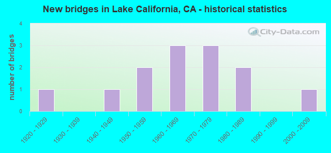
- New bridges - historical statistics
- 11920-1929
- 11940-1949
- 21950-1959
- 31960-1969
- 31970-1979
- 21980-1989
- 12000-2009

- Bridge Condition - Deck
- 61.5%Good
- 23.1%Satisfactory
- 15.4%Fair

- Bridge Condition - Superstructure
- 61.5%Good
- 23.1%Satisfactory
- 15.4%Fair

- Bridge Condition - Substructure
- 61.5%Good
- 7.7%Satisfactory
- 30.8%Fair

- Bridge Condition - Channel
- 38.5%Good
- 53.8%Satisfactory
- 7.7%Fair
Find on map >> Show street view
Structure Number: 6C0019, Location: 1.2 MI E BALLS FERRY RD (Lat: 40.417303, Lng: -122.194956), Route carried "on" structure: County highway , Year Built: 1970, Status: Open, Structure Length: 15.03m (49.31ft), Average Daily Traffic: 850 (year 2013), Truck Traffic: 5%, Average Future Daily Traffic: 3,265 (year 2040), Design Load: HS 20, Features Intersected: SACRAMENTO RIVER, Facility Carried by Structure: ASH CR RD
Minimum Vertical Clearance: 30+ m (98+ ft), Kilometerpoint: 0.000, Lanes on structure: 2, Owner: County Highway Agency, Approaching Roadway Width: 7.9m (25.9ft), Navigation Control: Yes ( Vertical Clearance: 7.6m (24.9ft), Horizontal Clearance: 39.6m (129.9ft)), Material/Design: Prestressed concrete, Design/Construction: Stringer/Multi-beam, Number Of Spans In Main Unit: 1, Number Of Approach Spans: 4, Length of Maximum Span: 42.6m (139.8ft), Curb-To-Curb Width: 8.4m (27.6ft), Out-to-Out Width: 8.6m (28.2ft)
Condition: Deck: Satisfactory, Superstructure: Satisfactory, Substructure: Fair, Channel: Satisfactory, Operating Rating: 43.7 metric tons, Method Used To Determine Operating Rating: Load and Resistance Factor Rating (LRFR) rating reported by rating factor(RF) method using HL-93 loadings, Inventory Rating: 20.4 metric tons, Method Used To Determine Inventory Rating: Load and Resistance Factor Rating (LRFR) rating reported by rating factor(RF) method using HL-93 loadings, Structural Evaluation: Somewhat better than minimum adequacy, Deck Geometry: Somewhat better than minimum adequacy, Waterway Adequacy: Better than present minimum criteria, Approach Roadway Alignment: Meets minimum limits, Designated Inspection Frequency: Every 24 months, Underwater Inspection Frequency: Every 60 months, Inspection Date: September 2020, Underwater Inspection Date: November 2017, Deck Structure Type: Concrete Cast-file-Place
Find on map >> Show street view
Structure Number: 6C0171, Location: 0.9 MI E BALLS FERRY RD (Lat: 40.415225, Lng: -122.200156), Route carried "on" structure: County highway , Year Built: 1977, Status: Open, Structure Length: 9.78m (32.09ft), Average Daily Traffic: 850 (year 2013), Truck Traffic: 5%, Average Future Daily Traffic: 3,265 (year 2040), Design Load: HS 20+Mod, Features Intersected: SACRAMENTO RIV OVERFLOW, Facility Carried by Structure: ASH CREEK ROAD
Minimum Vertical Clearance: 30+ m (98+ ft), Kilometerpoint: 0.000, Lanes on structure: 2, Owner: County Highway Agency, Approaching Roadway Width: 9.1m (29.9ft), Material/Design: Concrete continuous, Design/Construction: Slab, Number Of Spans In Main Unit: 15, Length of Maximum Span: 6.7m (22.0ft), Curb-To-Curb Width: 8.5m (27.9ft), Out-to-Out Width: 8.7m (28.5ft)
Condition: Deck: Good, Superstructure: Good, Substructure: Good, Channel: Satisfactory, Operating Rating: 64.8 metric tons, Method Used To Determine Operating Rating: Load Factor (LF), Inventory Rating: 40.8 metric tons, Method Used To Determine Inventory Rating: Load Factor (LF), Structural Evaluation: Better than present minimum criteria, Deck Geometry: Somewhat better than minimum adequacy, Waterway Adequacy: Superior to present desirable criteria, Approach Roadway Alignment: Equal to present minimum criteria, Designated Inspection Frequency: Every 48 months, Inspection Date: September 2018, Deck Structure Type: Concrete Cast-file-Place
Find on map >> Show street view
Structure Number: 6C0203, Location: 3.4 MI SE BALLS FERRY RD (Lat: 40.391278, Lng: -122.198469), Route carried "on" structure: County highway , Year Built: 1968, Status: Open, Structure Length: 4.72m (15.49ft), Average Daily Traffic: 10 (year 2013), Truck Traffic: 2%, Average Future Daily Traffic: 20 (year 2040), Features Intersected: ANDERSON CREEK, Facility Carried by Structure: ADOBE RD
Minimum Vertical Clearance: 30+ m (98+ ft), Kilometerpoint: 0.000, Lanes on structure: 1, Owner: County Highway Agency, Approaching Roadway Width: 6.4m (21.0ft), Material/Design: Wood or Timber, Design/Construction: Stringer/Multi-beam, Number Of Spans In Main Unit: 3, Length of Maximum Span: 15.8m (51.8ft), Curb-To-Curb Width: 4.0m (13.1ft), Out-to-Out Width: 4.2m (13.8ft)
Condition: Deck: Good, Superstructure: Good, Substructure: Fair, Channel: Good, Operating Rating: 25.9 metric tons, Method Used To Determine Operating Rating: Allowable Stress (AS), Inventory Rating: 13.6 metric tons, Method Used To Determine Inventory Rating: Allowable Stress (AS), Structural Evaluation: Meets minimum limits, Deck Geometry: Somewhat better than minimum adequacy, Waterway Adequacy: Superior to present desirable criteria, Approach Roadway Alignment: High priority of corrective action, Designated Inspection Frequency: Every 24 months, Inspection Date: September 2020, Deck Structure Type: Concrete Cast-file-Place
Find on map >> Show street view
Structure Number: 6C022, Location: 3.4 MI S DERSCH RD (Lat: 40.436636, Lng: -122.191972), Route carried "on" structure: County highway , Year Built: 1958, Status: Open, Structure Length: 1.49m (4.89ft), Average Daily Traffic: 130 (year 2013), Truck Traffic: 3%, Average Future Daily Traffic: 408 (year 2040), Features Intersected: ASH CREEK, Facility Carried by Structure: PARKVILLE RD
Minimum Vertical Clearance: 30+ m (98+ ft), Kilometerpoint: 0.000, Lanes on structure: 1, Owner: County Highway Agency, Approaching Roadway Width: 5.2m (17.1ft), Material/Design: Wood or Timber, Design/Construction: Stringer/Multi-beam, Number Of Spans In Main Unit: 2, Length of Maximum Span: 7.3m (24.0ft), Curb or Sidewalk Widths: Left: 0.3m (1.0ft), Right: 0.3m (1.0ft), Curb-To-Curb Width: 4.9m (16.1ft), Out-to-Out Width: 5.5m (18.0ft)
Condition: Deck: Good, Superstructure: Good, Substructure: Fair, Channel: Satisfactory, Operating Rating: 24.9 metric tons, Method Used To Determine Operating Rating: Allowable Stress (AS), Inventory Rating: 17.8 metric tons, Method Used To Determine Inventory Rating: Allowable Stress (AS), Structural Evaluation: Somewhat better than minimum adequacy, Deck Geometry: High priority of replacement, Waterway Adequacy: Better than present minimum criteria, Approach Roadway Alignment: Somewhat better than minimum adequacy, Designated Inspection Frequency: Every 24 months, Inspection Date: September 2020, Deck Structure Type: Wood or Timber, Wearing Surface/Protective System: Wearing Surface: Bituminous
Find on map >> Show street view
Structure Number: 6C0233, Location: 1.0 MI E BALLS FERRY RD (Lat: 40.416242, Lng: -122.197986), Route carried "on" structure: County highway , Year Built: 1927, Status: Open, Structure Length: 4.60m (15.09ft), Average Daily Traffic: 850 (year 2013), Truck Traffic: 5%, Average Future Daily Traffic: 2,448 (year 2040), Features Intersected: SACRAMENTO RIV OVERFLOW, Facility Carried by Structure: ASH CR RD
Minimum Vertical Clearance: 30+ m (98+ ft), Kilometerpoint: 0.000, Lanes on structure: 2, Owner: County Highway Agency, Approaching Roadway Width: 6.4m (21.0ft), Material/Design: Concrete, Design/Construction: Tee Beam, Number Of Spans In Main Unit: 5, Length of Maximum Span: 11.0m (36.1ft), Curb or Sidewalk Widths: Left: 0.2m (0.7ft), Right: 0.2m (0.7ft), Curb-To-Curb Width: 6.7m (22.0ft), Out-to-Out Width: 7.5m (24.6ft)
Condition: Deck: Fair, Superstructure: Good, Substructure: Satisfactory, Channel: Satisfactory, Operating Rating: 25.6 metric tons, Method Used To Determine Operating Rating: Field evaluation and documented engineering judgment, Inventory Rating: 15.2 metric tons, Method Used To Determine Inventory Rating: Field evaluation and documented engineering judgment, Structural Evaluation: Meets minimum limits, Deck Geometry: Meets minimum limits, Waterway Adequacy: Superior to present desirable criteria, Approach Roadway Alignment: Equal to present minimum criteria, Designated Inspection Frequency: Every 24 months, Inspection Date: September 2020, Deck Structure Type: Concrete Cast-file-Place
Find on map >> Show street view
Structure Number: 6C0242, Location: 100' E BALLS FERRY RD (Lat: 40.418031, Lng: -122.213725), Route carried "on" structure: County highway , Year Built: 1950, Status: Open, Structure Length: 3.11m (10.20ft), Average Daily Traffic: 1,161 (year 1996), Truck Traffic: 5%, Average Future Daily Traffic: 1,141 (year 2040), Design Load: H 20, Features Intersected: ANDERSON CREEK, Facility Carried by Structure: ASH CREEK ROAD
Minimum Vertical Clearance: 30+ m (98+ ft), Kilometerpoint: 0.000, Lanes on structure: 2, Owner: County Highway Agency, Approaching Roadway Width: 7.0m (23.0ft), Material/Design: Concrete continuous, Design/Construction: Slab, Number Of Spans In Main Unit: 5, Length of Maximum Span: 6.1m (20.0ft), Curb or Sidewalk Widths: Left: 0.2m (0.7ft), Right: 0.2m (0.7ft), Curb-To-Curb Width: 7.4m (24.3ft), Out-to-Out Width: 8.0m (26.2ft)
Condition: Deck: Fair, Superstructure: Fair, Substructure: Good, Channel: Fair, Operating Rating: 38.2 metric tons, Method Used To Determine Operating Rating: Load Factor (LF), Inventory Rating: 23.0 metric tons, Method Used To Determine Inventory Rating: Load Factor (LF), Structural Evaluation: Somewhat better than minimum adequacy, Deck Geometry: Meets minimum limits, Waterway Adequacy: Better than present minimum criteria, Approach Roadway Alignment: Equal to present minimum criteria, Designated Inspection Frequency: Every 24 months, Inspection Date: September 2020, Deck Structure Type: Concrete Cast-file-Place
Find on map >> Show street view
Structure Number: 6C026, Location: 0.1 MI N TEHAMA CO LINE (Lat: 40.391733, Lng: -122.178511), Route carried "on" structure: County highway , Year Built: 1961, Status: Open, Structure Length: 6.46m (21.19ft), Average Daily Traffic: 536 (year 2000), Truck Traffic: 5%, Average Future Daily Traffic: 1,027 (year 2038), Design Load: H 20, Features Intersected: BATTLE CREEK OVERFLOW, Facility Carried by Structure: GOVER ROAD
Minimum Vertical Clearance: 30+ m (98+ ft), Kilometerpoint: 0.000, Lanes on structure: 2, Owner: County Highway Agency, Approaching Roadway Width: 6.1m (20.0ft), Material/Design: Concrete continuous, Design/Construction: Slab, Number Of Spans In Main Unit: 9, Length of Maximum Span: 7.3m (24.0ft), Curb-To-Curb Width: 7.3m (24.0ft), Out-to-Out Width: 7.5m (24.6ft)
Condition: Deck: Good, Superstructure: Good, Substructure: Good, Channel: Satisfactory, Operating Rating: 50.2 metric tons, Method Used To Determine Operating Rating: Load Factor (LF), Inventory Rating: 30.1 metric tons, Method Used To Determine Inventory Rating: Load Factor (LF), Structural Evaluation: Better than present minimum criteria, Deck Geometry: Meets minimum limits, Waterway Adequacy: Superior to present desirable criteria, Approach Roadway Alignment: Meets minimum limits, Designated Inspection Frequency: Every 24 months, Inspection Date: September 2020, Deck Structure Type: Concrete Cast-file-Place, Wearing Surface/Protective System: Wearing Surface: Bituminous
Find on map >> Show street view
Structure Number: 6C0371, Location: 0.2 MI E BALLS FERRY RD (Lat: 40.422739, Lng: -122.214686), Route carried "on" structure: County highway , Year Built: 2006, Status: Open, Structure Length: 4.75m (15.58ft), Average Daily Traffic: 375 (year 1981), Truck Traffic: 5%, Average Future Daily Traffic: 547 (year 2042), Design Load: HS 20+Mod, Features Intersected: ANDERSON CREEK, Facility Carried by Structure: BLUE JAY LANE
Minimum Vertical Clearance: 30+ m (98+ ft), Kilometerpoint: 0.000, Lanes on structure: 2, Owner: County Highway Agency, Approaching Roadway Width: 7.3m (24.0ft), Skew: 2 degrees, Material/Design: Concrete continuous, Design/Construction: Slab, Number Of Spans In Main Unit: 4, Length of Maximum Span: 13.4m (44.0ft), Curb-To-Curb Width: 6.7m (22.0ft), Out-to-Out Width: 7.2m (23.6ft)
Condition: Deck: Satisfactory, Superstructure: Satisfactory, Substructure: Good, Channel: Satisfactory, Operating Rating: 54.1 metric tons, Method Used To Determine Operating Rating: Assigned rating based on Load Factor Design (LFD) reported in metric tons, Inventory Rating: 32.4 metric tons, Method Used To Determine Inventory Rating: Assigned rating based on Load Factor Design (LFD) reported in metric tons, Structural Evaluation: Equal to present minimum criteria, Deck Geometry: Meets minimum limits, Waterway Adequacy: Equal to present minimum criteria, Approach Roadway Alignment: Equal to present desirable criteria, Designated Inspection Frequency: Every 48 months, Inspection Date: September 2020, Deck Structure Type: Concrete Cast-file-Place
Find on map >> Show street view
Structure Number: 8C0043, Location: 7.2 MI NE OF I-5 (Lat: 40.316311, Lng: -122.190375), Route carried "on" structure: County highway , Year Built: 1949, Status: Open, Structure Length: 28.65m (94.00ft), Average Daily Traffic: 200 (year 2010), Truck Traffic: 5%, Average Future Daily Traffic: 416 (year 2042), Features Intersected: SACRAMENTO RIVER, Facility Carried by Structure: JELLYS FERRY RD
Minimum Vertical Clearance: 4.60m (15.09ft), Kilometerpoint: 0.000, Lanes on structure: 1, Owner: County Highway Agency, Approaching Roadway Width: 6.1m (20.0ft), Material/Design: Steel, Design/Construction: Truss - Thru, Number Of Spans In Main Unit: 5, Number Of Approach Spans: 10, Length of Maximum Span: 45.7m (149.9ft), Curb or Sidewalk Widths: Left: 0.2m (0.7ft), Right: 0.2m (0.7ft), Curb-To-Curb Width: 5.1m (16.7ft), Out-to-Out Width: 5.4m (17.7ft)
Condition: Deck: Good, Superstructure: Fair, Substructure: Fair, Channel: Good, Operating Rating: 27.5 metric tons, Method Used To Determine Operating Rating: Allowable Stress (AS), Inventory Rating: 20.1 metric tons, Method Used To Determine Inventory Rating: Allowable Stress (AS), Structural Evaluation: Somewhat better than minimum adequacy, Deck Geometry: High priority of replacement, Waterway Adequacy: Better than present minimum criteria, Approach Roadway Alignment: Somewhat better than minimum adequacy, Designated Inspection Frequency: Every 24 months, Critical Feature Inspection Frequency: Every 24 months, Underwater Inspection Frequency: Every 60 months, Inspection Date: July 2020, Critical Feature Inspection Date: August 2020, Underwater Inspection Date: November 2017, Deck Structure Type: Wood or Timber, Wearing Surface/Protective System: Wearing Surface: Bituminous
Find on map >> Show street view
Structure Number: 8C0168, Location: 2.0 MI EAST OF I-5 (Lat: 40.366458, Lng: -122.255669), Route carried "on" structure: County highway , Year Built: 1980, Status: Open, Structure Length: 2.19m (7.19ft), Average Daily Traffic: 1,695 (year 2010), Truck Traffic: 1%, Average Future Daily Traffic: 3,143 (year 2042), Design Load: HS 20, Features Intersected: NORTH FORK PATTERSON CRK, Facility Carried by Structure: LAKE CALIFORNIA DR
Minimum Vertical Clearance: 30+ m (98+ ft), Kilometerpoint: 0.000, Lanes on structure: 2, Owner: County Highway Agency, Approaching Roadway Width: 9.8m (32.2ft), Skew: 3 degrees, Material/Design: Concrete continuous, Design/Construction: Slab, Number Of Spans In Main Unit: 3, Length of Maximum Span: 7.3m (24.0ft), Curb-To-Curb Width: 9.7m (31.8ft), Out-to-Out Width: 10.0m (32.8ft)
Condition: Deck: Good, Superstructure: Good, Substructure: Good, Channel: Good, Operating Rating: 47.0 metric tons, Method Used To Determine Operating Rating: Load and Resistance Factor Rating (LRFR) rating reported by rating factor(RF) method using HL-93 loadings, Inventory Rating: 33.0 metric tons, Method Used To Determine Inventory Rating: Load and Resistance Factor Rating (LRFR) rating reported by rating factor(RF) method using HL-93 loadings, Structural Evaluation: Better than present minimum criteria, Deck Geometry: Somewhat better than minimum adequacy, Waterway Adequacy: Better than present minimum criteria, Approach Roadway Alignment: Equal to present desirable criteria, Designated Inspection Frequency: Every 48 months, Inspection Date: Febuary 2020, Deck Structure Type: Concrete Cast-file-Place, Wearing Surface/Protective System: Wearing Surface: Bituminous
Find on map >> Show street view
Structure Number: 8C0194, Location: 7.2 MI E OF I-5 (Lat: 40.313575, Lng: -122.193017), Route carried "on" structure: County highway , Year Built: 1964, Status: Open, Structure Length: 1.04m (3.41ft), Average Daily Traffic: 1,971 (year 2008), Truck Traffic: 5%, Average Future Daily Traffic: 3,143 (year 2042), Features Intersected: UNNAMED STREAM, Facility Carried by Structure: JELLYS FERRY RD
Minimum Vertical Clearance: 30+ m (98+ ft), Kilometerpoint: 0.000, Lanes on structure: 2, Owner: County Highway Agency, Approaching Roadway Width: 8.5m (27.9ft), Material/Design: Concrete, Design/Construction: Slab, Number Of Spans In Main Unit: 2, Length of Maximum Span: 4.9m (16.1ft), Curb-To-Curb Width: 10.7m (35.1ft), Out-to-Out Width: 10.9m (35.8ft)
Condition: Deck: Good, Superstructure: Good, Substructure: Good, Channel: Satisfactory, Operating Rating: 40.5 metric tons, Method Used To Determine Operating Rating: Field evaluation and documented engineering judgment, Inventory Rating: 24.3 metric tons, Method Used To Determine Inventory Rating: Field evaluation and documented engineering judgment, Structural Evaluation: Equal to present minimum criteria, Deck Geometry: Equal to present minimum criteria, Waterway Adequacy: Better than present minimum criteria, Approach Roadway Alignment: Equal to present desirable criteria, Designated Inspection Frequency: Every 24 months, Inspection Date: Febuary 2022, Deck Structure Type: Concrete Cast-file-Place
Find on map >> Show street view
Structure Number: 8C0195, Location: 12.3 MI E OF I-5 (Lat: 40.371944, Lng: -122.161056), Route carried "on" structure: Alternate County highway , Year Built: 1974, Status: Open, Structure Length: 2.19m (7.19ft), Average Daily Traffic: 1,695 (year 2010), Truck Traffic: 5%, Average Future Daily Traffic: 3,123 (year 2042), Features Intersected: UNNAMED STREAM, Facility Carried by Structure: JELLYS FERRY RD
Minimum Vertical Clearance: 30+ m (98+ ft), Kilometerpoint: 0.000, Lanes on structure: 2, Owner: County Highway Agency, Approaching Roadway Width: 9.1m (29.9ft), Material/Design: Concrete continuous, Design/Construction: Slab, Number Of Spans In Main Unit: 3, Length of Maximum Span: 7.3m (24.0ft), Curb-To-Curb Width: 9.8m (32.2ft), Out-to-Out Width: 10.0m (32.8ft)
Condition: Deck: Satisfactory, Superstructure: Satisfactory, Substructure: Good, Channel: Good, Operating Rating: 54.1 metric tons, Method Used To Determine Operating Rating: Field evaluation and documented engineering judgment, Inventory Rating: 32.4 metric tons, Method Used To Determine Inventory Rating: Field evaluation and documented engineering judgment, Structural Evaluation: Equal to present minimum criteria, Deck Geometry: Somewhat better than minimum adequacy, Waterway Adequacy: Better than present minimum criteria, Approach Roadway Alignment: Equal to present desirable criteria, Designated Inspection Frequency: Every 48 months, Inspection Date: Febuary 2020, Deck Structure Type: Concrete Cast-file-Place
Find on map >> Show street view
Structure Number: 8C0344, Location: TEHAMA/SHASTA CO LINE (Lat: 40.391689, Lng: -122.178489), Route carried "on" structure: County highway , Year Built: 1984, Status: Open, Structure Length: 7.07m (23.20ft), Average Daily Traffic: 184 (year 2004), Truck Traffic: 6%, Average Future Daily Traffic: 643 (year 2042), Design Load: HS 20+Mod, Features Intersected: BATTLE CREEK, Facility Carried by Structure: JELLYS FERRY RD
Minimum Vertical Clearance: 4.42m (14.50ft), Kilometerpoint: 0.000, Lanes on structure: 2, Owner: County Highway Agency, Approaching Roadway Width: 7.3m (24.0ft), Skew: 9 degrees, Material/Design: Concrete continuous, Design/Construction: Box Beam or Girders - Multiple, Number Of Spans In Main Unit: 2, Number Of Approach Spans: 3, Length of Maximum Span: 23.2m (76.1ft), Curb-To-Curb Width: 7.3m (24.0ft), Out-to-Out Width: 7.5m (24.6ft)
Condition: Deck: Good, Superstructure: Good, Substructure: Good, Channel: Good, Operating Rating: 83.6 metric tons, Method Used To Determine Operating Rating: Load Factor (LF), Inventory Rating: 50.2 metric tons, Method Used To Determine Inventory Rating: Load Factor (LF), Structural Evaluation: Better than present minimum criteria, Deck Geometry: Somewhat better than minimum adequacy, Waterway Adequacy: Better than present minimum criteria, Approach Roadway Alignment: Somewhat better than minimum adequacy, Designated Inspection Frequency: Every 48 months, Inspection Date: Febuary 2020, Deck Structure Type: Concrete Cast-file-Place, Wearing Surface/Protective System: Wearing Surface: Bituminous