Bridge Statistics for Lake Junaluska, North Carolina (NC)
Condition, Traffic, Stress, Structural Evaluation, Project Costs
- National Bridge Inventory (NBI) Statistics
- 25Number of bridges
- 312ft / 95.0mTotal length
- 193,190Total average daily traffic
- 31,774Total average daily truck traffic
- National Bridge Inventory (NBI) Registered Bridges for Lake Junaluska
- No street view available for this location
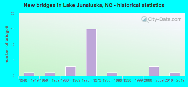
- New bridges - historical statistics
- 11940-1949
- 11950-1959
- 31960-1969
- 151970-1979
- 11980-1989
- 32000-2009
- 12010-2019


- Bridge Condition - Deck
- 6.3%Very good
- 56.3%Good
- 18.8%Satisfactory
- 12.5%Fair
- 6.3%Poor

- Bridge Condition - Superstructure
- 12.5%Very good
- 25.0%Good
- 25.0%Satisfactory
- 18.8%Fair
- 18.8%Poor

- Bridge Condition - Substructure
- 6.3%Very good
- 31.3%Good
- 43.8%Satisfactory
- 18.8%Fair

- Bridge Condition - Channel
- 16.7%Very good
- 75.0%Good
- 8.3%Fair
Find on map >> Show street view
Structure Number: 870036, Location: .8 MI.E.JCT.NC209 (Lat: 35.598522, Lng: -82.928419), Route carried "on" structure: State highway 1503, Year Built: 2009, Status: Open, Structure Length: 3.04m (9.97ft), Average Daily Traffic: 1,700 (year 2018), Truck Traffic: 6%, Average Future Daily Traffic: 3,400 (year 2040), Design Load: HS 25 or greater, Features Intersected: CRABTREE CREEK
Minimum Vertical Clearance: 30+ m (98+ ft), Kilometerpoint: 0.000, Lanes on structure: 2, Owner: State Highway Agency, Approaching Roadway Width: 6.0m (19.7ft), Skew: 3 degrees, Material/Design: Steel, Design/Construction: Stringer/Multi-beam, Number Of Spans In Main Unit: 1, Length of Maximum Span: 29.8m (97.8ft), Curb-To-Curb Width: 8.5m (27.9ft), Out-to-Out Width: 9.5m (31.2ft)
Condition: Deck: Good, Superstructure: Good, Substructure: Good, Channel: Good, Operating Rating: 89.8 metric tons, Method Used To Determine Operating Rating: Load Factor (LF), Inventory Rating: 64.4 metric tons, Method Used To Determine Inventory Rating: Load Factor (LF), Structural Evaluation: Better than present minimum criteria, Deck Geometry: Somewhat better than minimum adequacy, Waterway Adequacy: Better than present minimum criteria, Approach Roadway Alignment: Equal to present minimum criteria, Designated Inspection Frequency: Every 24 months, Inspection Date: May 2021, Deck Structure Type: Concrete Cast-file-Place, Wearing Surface/Protective System: Wearing Surface: Monolithic Concrete, Deck Protection: Epoxy Coated Reinforcing
Find on map >> Show street view
Structure Number: 870041, Location: 0.01 MI.S.JCT.SR1355 (Lat: 35.602742, Lng: -82.939264), Route carried "on" structure: State highway 1357, Year Built: 1956, Status: Posted for load, Structure Length: 1.85m (6.07ft), Average Daily Traffic: 150 (year 2019), Truck Traffic: 7%, Average Future Daily Traffic: 300 (year 2040), Features Intersected: CRABTREE CREEK
Minimum Vertical Clearance: 30+ m (98+ ft), Kilometerpoint: 0.000, Lanes on structure: 2, Owner: State Highway Agency, Approaching Roadway Width: 4.8m (15.7ft), Skew: 2 degrees, Material/Design: Steel, Design/Construction: Stringer/Multi-beam, Number Of Spans In Main Unit: 2, Length of Maximum Span: 8.8m (28.9ft), Curb-To-Curb Width: 5.3m (17.4ft), Out-to-Out Width: 5.6m (18.4ft)
Condition: Deck: Good, Superstructure: Poor, Substructure: Satisfactory, Channel: Good, Operating Rating: 13.6 metric tons, Method Used To Determine Operating Rating: Load Factor (LF), Inventory Rating: 8.1 metric tons, Method Used To Determine Inventory Rating: Load Factor (LF), Structural Evaluation: High priority of replacement, Deck Geometry: High priority of replacement, Waterway Adequacy: High priority of corrective action, Approach Roadway Alignment: Equal to present desirable criteria, Bridge Posting: Required (Relationship of Operating Rating to Maximum Legal Load: > 39.9% below), Designated Inspection Frequency: Every 24 months, Inspection Date: May 2021, Deck Structure Type: Wood or Timber, Wearing Surface/Protective System: Wearing Surface: Bituminous
Find on map >> Show street view
Structure Number: 870053, Location: 0.4 MI.W.JCT.SR1375 (Lat: 35.528950, Lng: -82.962650), Route carried "on" structure: State highway 1376, Year Built: 1970, Status: Posted for load, Structure Length: 1.24m (4.07ft), Average Daily Traffic: 1,600 (year 2018), Truck Traffic: 7%, Average Future Daily Traffic: 3,200 (year 2040), Features Intersected: RICHLAND CREEK
Minimum Vertical Clearance: 30+ m (98+ ft), Kilometerpoint: 0.000, Lanes on structure: 2, Owner: State Highway Agency, Approaching Roadway Width: 4.8m (15.7ft), Skew: 3 degrees, Material/Design: Steel, Design/Construction: Stringer/Multi-beam, Number Of Spans In Main Unit: 1, Length of Maximum Span: 11.5m (37.7ft), Curb-To-Curb Width: 7.4m (24.3ft), Out-to-Out Width: 7.7m (25.3ft)
Condition: Deck: Satisfactory, Superstructure: Fair, Substructure: Fair, Channel: Fair, Operating Rating: 16.3 metric tons, Method Used To Determine Operating Rating: Load Factor (LF), Inventory Rating: 9.9 metric tons, Method Used To Determine Inventory Rating: Load Factor (LF), Structural Evaluation: High priority of corrective action, Deck Geometry: Meets minimum limits, Waterway Adequacy: Equal to present minimum criteria, Approach Roadway Alignment: Equal to present desirable criteria, Bridge Posting: Required (Relationship of Operating Rating to Maximum Legal Load: > 39.9% below), Designated Inspection Frequency: Every 24 months, Underwater Inspection Frequency: Every 60 months, Inspection Date: May 2021, Underwater Inspection Date: May 2021, Deck Structure Type: Wood or Timber, Wearing Surface/Protective System: Wearing Surface: Bituminous
Find on map >> Show street view
Structure Number: 870054, Location: .1 MI.W.JCT.SR1375 (Lat: 35.527828, Lng: -82.962139), Route carried "on" structure: State highway 1376, Year Built: 1940, Status: Open, Structure Length: 1.61m (5.28ft), Average Daily Traffic: 1,600 (year 2018), Truck Traffic: 6%, Average Future Daily Traffic: 3,200 (year 2040), Features Intersected: RICHLAND CREEK
Minimum Vertical Clearance: 30+ m (98+ ft), Kilometerpoint: 0.000, Lanes on structure: 2, Owner: State Highway Agency, Approaching Roadway Width: 4.8m (15.7ft), Material/Design: Steel, Design/Construction: Stringer/Multi-beam, Number Of Spans In Main Unit: 2, Length of Maximum Span: 7.6m (24.9ft), Curb-To-Curb Width: 6.0m (19.7ft), Out-to-Out Width: 6.5m (21.3ft)
Condition: Deck: Good, Superstructure: Satisfactory, Substructure: Fair, Channel: Good, Operating Rating: 68.0 metric tons, Method Used To Determine Operating Rating: Load Factor (LF), Inventory Rating: 40.8 metric tons, Method Used To Determine Inventory Rating: Load Factor (LF), Structural Evaluation: Somewhat better than minimum adequacy, Deck Geometry: High priority of replacement, Waterway Adequacy: Better than present minimum criteria, Approach Roadway Alignment: Equal to present minimum criteria, Designated Inspection Frequency: Every 24 months, Underwater Inspection Frequency: Every 60 months, Inspection Date: May 2021, Underwater Inspection Date: May 2021, Deck Structure Type: Wood or Timber, Wearing Surface/Protective System: Wearing Surface: Bituminous
Find on map >> Show street view
Structure Number: 870084, Location: .1 MI.N.JCT.SR1364 (Lat: 35.569864, Lng: -82.957264), Route carried "on" structure: State highway 209, Year Built: 1974, Status: Open, Structure Length: 7.46m (24.48ft), Average Daily Traffic: 7,600 (year 2019), Truck Traffic: 7%, Average Future Daily Traffic: 15,200 (year 2040), Design Load: HS 20+Mod, Features Intersected: I-40
Minimum Vertical Clearance: 30+ m (98+ ft), Kilometerpoint: 7.379, Lanes on structure: 3, Lanes under structure: 5, Base Highway Network: Yes (Inventory Route: 3, Subroute: 9), Owner: State Highway Agency, Approaching Roadway Width: 15.8m (51.8ft), Skew: 2 degrees, Material/Design: Steel continuous, Design/Construction: Stringer/Multi-beam, Number Of Spans In Main Unit: 2, Length of Maximum Span: 40.2m (131.9ft), Curb-To-Curb Width: 16.8m (55.1ft), Out-to-Out Width: 17.6m (57.7ft)
Condition: Deck: Poor, Superstructure: Satisfactory, Substructure: Satisfactory, Operating Rating: 89.8 metric tons, Method Used To Determine Operating Rating: Load Factor (LF), Inventory Rating: 57.1 metric tons, Method Used To Determine Inventory Rating: Load Factor (LF), Structural Evaluation: Equal to present minimum criteria, Deck Geometry: Superior to present desirable criteria, Underclear: High priority of corrective action, Approach Roadway Alignment: Equal to present desirable criteria, Designated Inspection Frequency: Every 24 months, Inspection Date: May 2021, Deck Structure Type: Concrete Cast-file-Place, Wearing Surface/Protective System: Wearing Surface: Monolithic Concrete
Find on map >> Show street view
Structure Number: 870094, Location: 1.0 MI.N.JCT.US276 (Lat: 35.517722, Lng: -82.974928), Route carried "on" structure: US 19, Year Built: 2007, Status: Open, Structure Length: 9.14m (29.99ft), Average Daily Traffic: 14,000 (year 2018), Truck Traffic: 12%, Average Future Daily Traffic: 28,000 (year 2040), Design Load: HS 20+Mod, Features Intersected: RICHLAND CREEK
Minimum Vertical Clearance: 30+ m (98+ ft), Kilometerpoint: 0.000, Lanes on structure: 5, Owner: State Highway Agency, Approaching Roadway Width: 19.5m (64.0ft), Skew: 9 degrees, Material/Design: Prestressed concrete continuous, Design/Construction: Stringer/Multi-beam, Number Of Spans In Main Unit: 5, Length of Maximum Span: 21.0m (68.9ft), Curb or Sidewalk Widths: Left: 1.6m (5.2ft), Right: 1.6m (5.2ft), Curb-To-Curb Width: 19.6m (64.3ft), Out-to-Out Width: 23.6m (77.4ft)
Condition: Deck: Very good, Superstructure: Very good, Substructure: Very good, Channel: Very good, Operating Rating: 66.2 metric tons, Method Used To Determine Operating Rating: Load Factor (LF), Inventory Rating: 38.1 metric tons, Method Used To Determine Inventory Rating: Load Factor (LF), Structural Evaluation: Equal to present desirable criteria, Deck Geometry: Meets minimum limits, Waterway Adequacy: Equal to present desirable criteria, Approach Roadway Alignment: Equal to present desirable criteria, Designated Inspection Frequency: Every 24 months, Underwater Inspection Frequency: Every 60 months, Inspection Date: May 2021, Underwater Inspection Date: June 2021, Deck Structure Type: Concrete Cast-file-Place, Wearing Surface/Protective System: Wearing Surface: Epoxy Overlay
Find on map >> Show street view
Structure Number: 870098, Location: 150 FT.S.JCT.SR1649 (Lat: 35.580697, Lng: -82.945897), Route carried "on" structure: State highway 209, Year Built: 1972, Status: Open, Structure Length: 12.49m (40.98ft), Average Daily Traffic: 6,500 (year 2019), Truck Traffic: 7%, Average Future Daily Traffic: 13,000 (year 2040), Design Load: HS 20+Mod, Features Intersected: PIGEON RIVER
Minimum Vertical Clearance: 30+ m (98+ ft), Kilometerpoint: 0.000, Lanes on structure: 2, Owner: State Highway Agency, Approaching Roadway Width: 10.0m (32.8ft), Material/Design: Steel, Design/Construction: Stringer/Multi-beam, Number Of Spans In Main Unit: 3, Length of Maximum Span: 41.1m (134.8ft), Curb-To-Curb Width: 12.1m (39.7ft), Out-to-Out Width: 12.9m (42.3ft)
Condition: Deck: Fair, Superstructure: Fair, Substructure: Fair, Channel: Good, Operating Rating: 58.0 metric tons, Method Used To Determine Operating Rating: Load Factor (LF), Inventory Rating: 34.4 metric tons, Method Used To Determine Inventory Rating: Load Factor (LF), Structural Evaluation: Somewhat better than minimum adequacy, Deck Geometry: Somewhat better than minimum adequacy, Waterway Adequacy: Equal to present desirable criteria, Approach Roadway Alignment: Equal to present desirable criteria, Designated Inspection Frequency: Every 24 months, Underwater Inspection Frequency: Every 60 months, Inspection Date: April 2021, Underwater Inspection Date: December 2019, Deck Structure Type: Concrete Cast-file-Place, Wearing Surface/Protective System: Wearing Surface: Monolithic Concrete
Find on map >> Show street view
Structure Number: 870113, Location: .01 MI.N.JCT.SR1503 (Lat: 35.598178, Lng: -82.933753), Route carried "on" structure: State highway 209, Year Built: 1984, Year Reconstructed: 2013, Status: Open, Structure Length: 4.54m (14.90ft), Average Daily Traffic: 2,100 (year 2019), Truck Traffic: 7%, Average Future Daily Traffic: 4,200 (year 2040), Design Load: HS 20+Mod, Features Intersected: CRABTREE CREEK
Minimum Vertical Clearance: 30+ m (98+ ft), Kilometerpoint: 0.000, Lanes on structure: 2, Owner: State Highway Agency, Approaching Roadway Width: 8.8m (28.9ft), Skew: 9 degrees, Material/Design: Prestressed concrete, Design/Construction: Stringer/Multi-beam, Number Of Spans In Main Unit: 3, Length of Maximum Span: 14.3m (46.9ft), Curb-To-Curb Width: 9.1m (29.9ft), Out-to-Out Width: 10.0m (32.8ft)
Condition: Deck: Satisfactory, Superstructure: Fair, Substructure: Satisfactory, Channel: Good, Operating Rating: 83.4 metric tons, Method Used To Determine Operating Rating: Load Factor (LF), Inventory Rating: 35.3 metric tons, Method Used To Determine Inventory Rating: Load Factor (LF), Structural Evaluation: Somewhat better than minimum adequacy, Deck Geometry: Meets minimum limits, Waterway Adequacy: Better than present minimum criteria, Approach Roadway Alignment: Equal to present desirable criteria, Designated Inspection Frequency: Every 24 months, Inspection Date: May 2021, Deck Structure Type: Concrete Cast-file-Place, Wearing Surface/Protective System: Wearing Surface: Latex Concrete
Find on map >> Show street view
Structure Number: 870133, Location: .8 MI.S.JCT.SR1660 (Lat: 35.528608, Lng: -82.939989), Route carried "on" structure: US 19, Year Built: 1969, Status: Open, Structure Length: 3.68m (12.07ft), Average Daily Traffic: 43,500 (year 2018), Truck Traffic: 12%, Average Future Daily Traffic: 87,000 (year 2040), Design Load: HS 20+Mod, Features Intersected: SR1527
Minimum Vertical Clearance: 30+ m (98+ ft), Kilometerpoint: 32.034, Lanes on structure: 4, Lanes under structure: 3, Base Highway Network: Yes (Inventory Route: 2, Subroute: 19), Owner: State Highway Agency, Approaching Roadway Width: 25.6m (84.0ft), Skew: 20 degrees, Material/Design: Steel, Design/Construction: Stringer/Multi-beam, Number Of Spans In Main Unit: 3, Length of Maximum Span: 14.0m (45.9ft), Curb-To-Curb Width: 26.1m (85.6ft), Out-to-Out Width: 27.5m (90.2ft)
Condition: Deck: Fair, Superstructure: Poor, Substructure: Satisfactory, Operating Rating: 55.3 metric tons, Method Used To Determine Operating Rating: Load Factor (LF), Inventory Rating: 32.6 metric tons, Method Used To Determine Inventory Rating: Load Factor (LF), Structural Evaluation: Meets minimum limits, Deck Geometry: Superior to present desirable criteria, Underclear: High priority of corrective action, Approach Roadway Alignment: Equal to present desirable criteria, Designated Inspection Frequency: Every 24 months, Inspection Date: Febuary 2021, Deck Structure Type: Concrete Cast-file-Place, Wearing Surface/Protective System: Wearing Surface: Bituminous
Find on map >> Show street view
Structure Number: 870173, Location: 150 FT.W.JCT.SR1357 (Lat: 35.603031, Lng: -82.939956), Route carried "on" structure: State highway 1355, Year Built: 1969, Status: Posted for load, Structure Length: 1.24m (4.07ft), Average Daily Traffic: 650 (year 2019), Truck Traffic: 6%, Average Future Daily Traffic: 1,300 (year 2040), Features Intersected: RUSH FORK CREEK
Minimum Vertical Clearance: 30+ m (98+ ft), Kilometerpoint: 0.000, Lanes on structure: 2, Owner: State Highway Agency, Approaching Roadway Width: 6.0m (19.7ft), Skew: 4 degrees, Material/Design: Steel, Design/Construction: Stringer/Multi-beam, Number Of Spans In Main Unit: 1, Length of Maximum Span: 11.8m (38.7ft), Curb-To-Curb Width: 7.3m (24.0ft), Out-to-Out Width: 7.6m (24.9ft)
Condition: Deck: Good, Superstructure: Poor, Substructure: Satisfactory, Channel: Good, Operating Rating: 21.7 metric tons, Method Used To Determine Operating Rating: Load Factor (LF), Inventory Rating: 12.7 metric tons, Method Used To Determine Inventory Rating: Load Factor (LF), Structural Evaluation: Meets minimum limits, Deck Geometry: Meets minimum limits, Waterway Adequacy: Somewhat better than minimum adequacy, Approach Roadway Alignment: Equal to present minimum criteria, Bridge Posting: Required (Relationship of Operating Rating to Maximum Legal Load: > 39.9% below), Designated Inspection Frequency: Every 24 months, Inspection Date: May 2021, Deck Structure Type: Wood or Timber, Wearing Surface/Protective System: Wearing Surface: Bituminous
Find on map >> Show street view
Structure Number: 870209, Location: 1 MI.W.JCT.NC209 (Lat: 35.576539, Lng: -82.979386), Route carried "on" structure: Interstate 40, Year Built: 1974, Status: Open, Structure Length: 3.56m (11.68ft), Average Daily Traffic: 14,000 (year 2019), Truck Traffic: 23%, Average Future Daily Traffic: 28,000 (year 2040), Design Load: HS 20+Mod, Features Intersected: SR1366
Minimum Vertical Clearance: 30+ m (98+ ft), Kilometerpoint: 6.980, Lanes on structure: 2, Lanes under structure: 2, Base Highway Network: Yes (Inventory Route: 1, Subroute: 40), Owner: State Highway Agency, Approaching Roadway Width: 11.8m (38.7ft), Skew: 10 degrees, Material/Design: Steel continuous, Design/Construction: Stringer/Multi-beam, Number Of Spans In Main Unit: 3, Length of Maximum Span: 15.2m (49.9ft), Curb-To-Curb Width: 11.9m (39.0ft), Out-to-Out Width: 12.8m (42.0ft)
Condition: Deck: Good, Superstructure: Good, Substructure: Good, Operating Rating: 62.5 metric tons, Method Used To Determine Operating Rating: Load Factor (LF), Inventory Rating: 37.1 metric tons, Method Used To Determine Inventory Rating: Load Factor (LF), Structural Evaluation: Better than present minimum criteria, Deck Geometry: Equal to present minimum criteria, Underclear: Meets minimum limits, Approach Roadway Alignment: Equal to present desirable criteria, Designated Inspection Frequency: Every 24 months, Inspection Date: May 2021, Deck Structure Type: Concrete Cast-file-Place, Wearing Surface/Protective System: Wearing Surface: Monolithic Concrete
Find on map >> Show street view
Structure Number: 870222, Location: 1.0 MI.W.JCT.NC209 (Lat: 35.576683, Lng: -82.979244), Route carried "on" structure: Interstate 40, Year Built: 1974, Status: Open, Structure Length: 3.56m (11.68ft), Average Daily Traffic: 14,000 (year 2019), Truck Traffic: 23%, Average Future Daily Traffic: 28,000 (year 2040), Design Load: HS 20+Mod, Features Intersected: SR1366
Minimum Vertical Clearance: 30+ m (98+ ft), Kilometerpoint: 6.980, Lanes on structure: 2, Lanes under structure: 2, Base Highway Network: Yes (Inventory Route: 1, Subroute: 40), Owner: State Highway Agency, Approaching Roadway Width: 11.8m (38.7ft), Skew: 10 degrees, Material/Design: Steel continuous, Design/Construction: Stringer/Multi-beam, Number Of Spans In Main Unit: 3, Length of Maximum Span: 14.9m (48.9ft), Curb-To-Curb Width: 11.9m (39.0ft), Out-to-Out Width: 12.8m (42.0ft)
Condition: Deck: Good, Superstructure: Good, Substructure: Good, Operating Rating: 63.5 metric tons, Method Used To Determine Operating Rating: Load Factor (LF), Inventory Rating: 37.1 metric tons, Method Used To Determine Inventory Rating: Load Factor (LF), Structural Evaluation: Better than present minimum criteria, Deck Geometry: Equal to present minimum criteria, Underclear: Meets minimum limits, Approach Roadway Alignment: Equal to present desirable criteria, Designated Inspection Frequency: Every 24 months, Inspection Date: May 2021, Deck Structure Type: Concrete Cast-file-Place, Wearing Surface/Protective System: Wearing Surface: Monolithic Concrete
Find on map >> Show street view
Structure Number: 870228, Location: .1 MI.E.JCT.NC209 (Lat: 35.567222, Lng: -82.953819), Route carried "on" structure: Interstate 40, Year Built: 1974, Status: Open, Structure Length: 14.63m (48.00ft), Average Daily Traffic: 14,250 (year 2019), Truck Traffic: 23%, Average Future Daily Traffic: 28,500 (year 2040), Design Load: HS 20+Mod, Features Intersected: PIGEON RIVER
Minimum Vertical Clearance: 30+ m (98+ ft), Kilometerpoint: 7.345, Lanes on structure: 2, Base Highway Network: Yes (Inventory Route: 1, Subroute: 40), Owner: State Highway Agency, Approaching Roadway Width: 12.8m (42.0ft), Skew: 13 degrees, Material/Design: Steel, Design/Construction: Stringer/Multi-beam, Number Of Spans In Main Unit: 5, Length of Maximum Span: 28.6m (93.8ft), Curb-To-Curb Width: 12.0m (39.4ft), Out-to-Out Width: 12.8m (42.0ft)
Condition: Deck: Satisfactory, Superstructure: Satisfactory, Substructure: Satisfactory, Channel: Good, Operating Rating: 59.8 metric tons, Method Used To Determine Operating Rating: Load Factor (LF), Inventory Rating: 35.3 metric tons, Method Used To Determine Inventory Rating: Load Factor (LF), Structural Evaluation: Equal to present minimum criteria, Deck Geometry: Equal to present minimum criteria, Waterway Adequacy: Better than present minimum criteria, Approach Roadway Alignment: Equal to present desirable criteria, Designated Inspection Frequency: Every 24 months, Underwater Inspection Frequency: Every 60 months, Inspection Date: April 2021, Underwater Inspection Date: December 2019, Deck Structure Type: Concrete Cast-file-Place, Wearing Surface/Protective System: Wearing Surface: Bituminous
Find on map >> Show street view
Structure Number: 87023, Location: .1 MI.E.JCT.NC209 (Lat: 35.567256, Lng: -82.953592), Route carried "on" structure: Interstate 40, Year Built: 1974, Status: Open, Structure Length: 14.63m (48.00ft), Average Daily Traffic: 14,250 (year 2019), Truck Traffic: 23%, Average Future Daily Traffic: 28,500 (year 2040), Design Load: HS 20+Mod, Features Intersected: PIGEON RIVER
Minimum Vertical Clearance: 30+ m (98+ ft), Kilometerpoint: 7.345, Lanes on structure: 2, Base Highway Network: Yes (Inventory Route: 1, Subroute: 40), Owner: State Highway Agency, Approaching Roadway Width: 12.1m (39.7ft), Skew: 13 degrees, Material/Design: Steel, Design/Construction: Stringer/Multi-beam, Number Of Spans In Main Unit: 5, Length of Maximum Span: 28.6m (93.8ft), Curb-To-Curb Width: 12.0m (39.4ft), Out-to-Out Width: 12.8m (42.0ft)
Condition: Deck: Good, Superstructure: Satisfactory, Substructure: Satisfactory, Channel: Good, Operating Rating: 89.8 metric tons, Method Used To Determine Operating Rating: Load Factor (LF), Inventory Rating: 53.5 metric tons, Method Used To Determine Inventory Rating: Load Factor (LF), Structural Evaluation: Equal to present minimum criteria, Deck Geometry: Equal to present minimum criteria, Waterway Adequacy: Equal to present desirable criteria, Approach Roadway Alignment: Equal to present desirable criteria, Designated Inspection Frequency: Every 24 months, Underwater Inspection Frequency: Every 60 months, Inspection Date: April 2021, Underwater Inspection Date: December 2019, Deck Structure Type: Concrete Cast-file-Place, Wearing Surface/Protective System: Wearing Surface: Bituminous
Find on map >> Show street view
Structure Number: 870232, Location: 1.7 MI.E.JCT.NC209 (Lat: 35.550414, Lng: -82.938886), Route carried "on" structure: Interstate 40, Year Built: 1974, Status: Open, Structure Length: 4.66m (15.29ft), Average Daily Traffic: 12,000 (year 2015), Truck Traffic: 23%, Average Future Daily Traffic: 24,000 (year 2040), Design Load: HS 20+Mod, Features Intersected: SR1513
Minimum Vertical Clearance: 30+ m (98+ ft), Kilometerpoint: 7.909, Lanes on structure: 2, Lanes under structure: 2, Base Highway Network: Yes (Inventory Route: 1, Subroute: 40), Owner: State Highway Agency, Approaching Roadway Width: 10.9m (35.8ft), Skew: 11 degrees, Material/Design: Steel continuous, Design/Construction: Stringer/Multi-beam, Number Of Spans In Main Unit: 3, Length of Maximum Span: 19.2m (63.0ft), Curb-To-Curb Width: 12.1m (39.7ft), Out-to-Out Width: 12.8m (42.0ft)
Condition: Deck: Good, Superstructure: Very good, Substructure: Good, Operating Rating: 72.5 metric tons, Method Used To Determine Operating Rating: Load Factor (LF), Inventory Rating: 43.5 metric tons, Method Used To Determine Inventory Rating: Load Factor (LF), Structural Evaluation: Better than present minimum criteria, Deck Geometry: Equal to present minimum criteria, Underclear: Better than present minimum criteria, Approach Roadway Alignment: Equal to present desirable criteria, Designated Inspection Frequency: Every 24 months, Inspection Date: April 2021, Deck Structure Type: Concrete Cast-file-Place, Wearing Surface/Protective System: Wearing Surface: Bituminous
Find on map >> Show street view
Structure Number: 870291, Location: 50 FT.E.JCT.NC209 (Lat: 35.561764, Lng: -82.954139), Route carried "on" structure: State highway 1625, Year Built: 2000, Status: Open, Structure Length: 7.01m (23.00ft), Average Daily Traffic: 990 (year 2010), Truck Traffic: 6%, Average Future Daily Traffic: 1,980 (year 2040), Design Load: HS 20+Mod, Features Intersected: PIGEON RIVER
Minimum Vertical Clearance: 30+ m (98+ ft), Kilometerpoint: 0.000, Lanes on structure: 2, Owner: State Highway Agency, Approaching Roadway Width: 6.7m (22.0ft), Material/Design: Prestressed concrete, Design/Construction: Slab, Number Of Spans In Main Unit: 5, Length of Maximum Span: 17.6m (57.7ft), Curb-To-Curb Width: 7.1m (23.3ft), Out-to-Out Width: 8.2m (26.9ft)
Condition: Deck: Good, Superstructure: Good, Substructure: Good, Channel: Very good, Operating Rating: 64.4 metric tons, Method Used To Determine Operating Rating: Load Factor (LF), Inventory Rating: 38.1 metric tons, Method Used To Determine Inventory Rating: Load Factor (LF), Structural Evaluation: Better than present minimum criteria, Deck Geometry: Meets minimum limits, Waterway Adequacy: Equal to present desirable criteria, Approach Roadway Alignment: Equal to present minimum criteria, Designated Inspection Frequency: Every 24 months, Inspection Date: December 2020, Deck Structure Type: Concrete Precast Panels, Wearing Surface/Protective System: Wearing Surface: Bituminous, Deck Protection: Epoxy Coated Reinforcing
Find on map >> Show street view
Structure Number: 870467, Location: 0.01MI.W.JCT.US-23 BUS. (Lat: 35.511611, Lng: -82.935056), Route carried "on" structure: State highway 1184, Year Built: 2017, Status: Open, Structure Length: 0.64m (2.10ft), Average Daily Traffic: 4,200 (year 2018), Truck Traffic: 6%, Average Future Daily Traffic: 8,400 (year 2040), Design Load: HL 93, Features Intersected: RACOON CREEK
Minimum Vertical Clearance: 30+ m (98+ ft), Kilometerpoint: 0.000, Lanes on structure: 4, Owner: State Highway Agency, Approaching Roadway Width: 13.7m (44.9ft), Skew: 21 degrees, Material/Design: Concrete continuous, Design/Construction: Culvert, Number Of Spans In Main Unit: 2, Length of Maximum Span: 3.0m (9.8ft)
Condition: Channel: Good, Culverts: Good, Operating Rating: 55.3 metric tons, Method Used To Determine Operating Rating: Load and Resistance Factor (LRFR), Inventory Rating: 42.6 metric tons, Method Used To Determine Inventory Rating: Load and Resistance Factor (LRFR), Structural Evaluation: Better than present minimum criteria, Waterway Adequacy: Better than present minimum criteria, Approach Roadway Alignment: Equal to present desirable criteria, Designated Inspection Frequency: Every 24 months, Inspection Date: June 2021
Find on map >> Show street view
Structure Number: 870084, Location: .1 MI.N.JCT.SR1364 (Lat: 35.569864, Lng: -82.957264), Route carried "under" structure: Interstate 40, Year Built: 1974, Structure Length: 0. m, Average Daily Traffic: 14,250 (year 2017), Truck Traffic: 23%, Features Intersected: NC209
Minimum Vertical Clearance: 6.52m (21.39ft), Kilometerpoint: 7.379, Lanes on structure: 3, Lanes under structure: 3, Material/Design: Steel continuous, Design/Construction: Stringer/Multi-beam, Length of Maximum Span: 40.2m (131.9ft)
Find on map >> Show street view
Structure Number: 870084, Location: .1 MI.N.JCT.SR1364 (Lat: 35.569864, Lng: -82.957264), Route carried "under" structure: Interstate 40, Year Built: 1974, Structure Length: 0. m, Average Daily Traffic: 14,250 (year 2017), Truck Traffic: 23%, Features Intersected: NC209
Minimum Vertical Clearance: 5.25m (17.22ft), Kilometerpoint: 7.379, Lanes on structure: 3, Lanes under structure: 2, Material/Design: Steel continuous, Design/Construction: Stringer/Multi-beam, Length of Maximum Span: 40.2m (131.9ft)
Find on map >> Show street view
Structure Number: 870133, Location: .8 MI.S.JCT.SR1660 (Lat: 35.528608, Lng: -82.939989), Route carried "under" structure: State highway 1527, Year Built: 1969, Structure Length: 0. m, Average Daily Traffic: 6,000 (year 2016), Truck Traffic: 7%, Features Intersected: US19,23,74
Minimum Vertical Clearance: 4.85m (15.91ft), Kilometerpoint: 0.000, Lanes on structure: 4, Lanes under structure: 3, Material/Design: Steel, Design/Construction: Stringer/Multi-beam, Length of Maximum Span: 14.0m (45.9ft)
Find on map >> Show street view
Structure Number: 870209, Location: 1 MI.W.JCT.NC209 (Lat: 35.576539, Lng: -82.979386), Route carried "under" structure: State highway 1366, Year Built: 1974, Structure Length: 0. m, Average Daily Traffic: 750 (year 2019), Truck Traffic: 6%, Features Intersected: I40 EBL
Minimum Vertical Clearance: 4.74m (15.55ft), Kilometerpoint: 0.000, Lanes on structure: 2, Lanes under structure: 2, Material/Design: Steel continuous, Design/Construction: Stringer/Multi-beam, Length of Maximum Span: 15.2m (49.9ft)
Find on map >> Show street view
Structure Number: 870222, Location: 1.0 MI.W.JCT.NC209 (Lat: 35.576683, Lng: -82.979244), Route carried "under" structure: State highway 1366, Year Built: 1974, Structure Length: 0. m, Average Daily Traffic: 750 (year 2019), Truck Traffic: 6%, Features Intersected: I40 WBL
Minimum Vertical Clearance: 6.73m (22.08ft), Kilometerpoint: 0.000, Lanes on structure: 2, Lanes under structure: 2, Material/Design: Steel continuous, Design/Construction: Stringer/Multi-beam, Length of Maximum Span: 14.9m (48.9ft)
Find on map >> Show street view
Structure Number: 870223, Location: 0.5 MI.W.JCT.NC209 (Lat: 35.571592, Lng: -82.965122), Route carried "under" structure: State highway 1364, Year Built: 1974, Structure Length: 0. m, Average Daily Traffic: 1,700 (year 2014), Truck Traffic: 6%, Features Intersected: I-40 EBL
Minimum Vertical Clearance: 7.59m (24.90ft), Kilometerpoint: 0.000, Lanes on structure: 2, Lanes under structure: 2, Material/Design: Steel continuous, Design/Construction: Stringer/Multi-beam, Length of Maximum Span: 21.6m (70.9ft)
Find on map >> Show street view
Structure Number: 870224, Location: .5 MI.W.JCT.NC209 (Lat: 35.571772, Lng: -82.965222), Route carried "under" structure: State highway 1364, Year Built: 1974, Structure Length: 0. m, Average Daily Traffic: 1,800 (year 2016), Truck Traffic: 6%, Features Intersected: I-40 WBL
Minimum Vertical Clearance: 6.90m (22.64ft), Kilometerpoint: 0.000, Lanes on structure: 2, Lanes under structure: 2, Material/Design: Steel continuous, Design/Construction: Stringer/Multi-beam, Length of Maximum Span: 21.6m (70.9ft)
Find on map >> Show street view
Structure Number: 870232, Location: 1.7 MI.E.JCT.NC209 (Lat: 35.550414, Lng: -82.938886), Route carried "under" structure: State highway 1513, Year Built: 1974, Structure Length: 0. m, Average Daily Traffic: 600 (year 2016), Truck Traffic: 7%, Features Intersected: I-40 WBL
Minimum Vertical Clearance: 7.94m (26.05ft), Kilometerpoint: 7.909, Lanes on structure: 2, Lanes under structure: 2, Material/Design: Steel continuous, Design/Construction: Stringer/Multi-beam, Length of Maximum Span: 19.2m (63.0ft)