Bridge Statistics for Lakeville, Massachusetts (MA)
Condition, Traffic, Stress, Structural Evaluation, Project Costs
- National Bridge Inventory (NBI) Statistics
- 11Number of bridges
- 89ft / 26.8mTotal length
- $16,966,000Total costs
- 73,095Total average daily traffic
- 4,997Total average daily truck traffic
- 182,797Total future (year 2031) average daily traffic
- National Bridge Inventory (NBI) Registered Bridges for Lakeville
- No street view available for this location
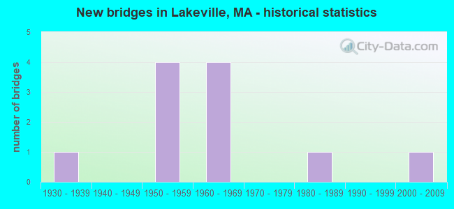
- New bridges - historical statistics
- 11930-1939
- 41950-1959
- 41960-1969
- 11980-1989
- 12000-2009


- Bridge Condition - Deck
- 27.3%Very good
- 54.5%Satisfactory
- 18.2%Fair

- Bridge Condition - Superstructure
- 27.3%Very good
- 27.3%Good
- 36.4%Satisfactory
- 9.1%Fair

- Bridge Condition - Substructure
- 9.1%Very good
- 54.5%Good
- 27.3%Satisfactory
- 9.1%Fair

- Bridge Condition - Channel
- 33.3%Very good
- 66.7%Good
Find on map >> Show street view
Structure Number: L01001419DOT634, Location: 0.1MI WEST OF SHERWOOD LN (Lat: 41.798047, Lng: -70.996333), Route carried "on" structure: City street , Year Built: 1984, Status: Open, Structure Length: 2.35m (7.71ft), Average Daily Traffic: 2,936 (year 2017), Truck Traffic: 6%, Average Future Daily Traffic: 5,528 (year 2032), Design Load: HS 20+Mod, Features Intersected: RR MACRR, Facility Carried by Structure: HWY HOWLAND RD
Minimum Vertical Clearance: 30+ m (98+ ft), Kilometerpoint: 0.000, Lanes on structure: 2, Owner: State Highway Agency, Approaching Roadway Width: 12.2m (40.0ft), Skew: 3 degrees, Material/Design: Steel, Design/Construction: Stringer/Multi-beam, Number Of Spans In Main Unit: 1, Length of Maximum Span: 21.9m (71.9ft), Curb or Sidewalk Widths: Left: 0.2m (0.7ft), Right: 1.5m (4.9ft), Curb-To-Curb Width: 12.2m (40.0ft), Out-to-Out Width: 14.8m (48.6ft)
Condition: Deck: Satisfactory, Superstructure: Good, Substructure: Good, Operating Rating: 68.3 metric tons, Method Used To Determine Operating Rating: Load Factor (LF), Inventory Rating: 40.9 metric tons, Method Used To Determine Inventory Rating: Load Factor (LF), Structural Evaluation: Better than present minimum criteria, Deck Geometry: Equal to present minimum criteria, Underclear: Meets minimum limits, Approach Roadway Alignment: Equal to present desirable criteria, Length Of Structure Improvement: 2.40m (7.87ft), Designated Inspection Frequency: Every 24 months, Inspection Date: January 2021, Bridge Improvement Cost: $272,000, Roadway Improvement Cost: $28,000, Total Project Cost: $409,000 ( Estimate for 2022), Deck Structure Type: Concrete Cast-file-Place, Wearing Surface/Protective System: Wearing Surface: Bituminous, Membrane: Built-up, Deck Protection: Epoxy Coated Reinforcing
Find on map >> Show street view
Structure Number: L01003AFEMUNNBI, Location: MIDDLEBORO TOWN LINE (Lat: 41.859528, Lng: -70.916758), Route carried "on" structure: City street , Year Built: 2002, Status: Open, Structure Length: 1.85m (6.07ft), Average Daily Traffic: 1,000 (year 2019), Truck Traffic: 6%, Average Future Daily Traffic: 1,579 (year 2031), Design Load: HS 20, Features Intersected: WATER NEMASKET RIVER, Facility Carried by Structure: HWY VAUGHN ST
Minimum Vertical Clearance: 30+ m (98+ ft), Kilometerpoint: 0.016, Lanes on structure: 2, Owner: Town or Township Highway Agency, Approaching Roadway Width: 7.0m (23.0ft), Material/Design: Prestressed concrete, Design/Construction: Box Beam or Girders - Multiple, Number Of Spans In Main Unit: 1, Length of Maximum Span: 17.3m (56.8ft), Curb-To-Curb Width: 6.7m (22.0ft), Out-to-Out Width: 7.6m (24.9ft)
Condition: Deck: Very good, Superstructure: Very good, Substructure: Very good, Channel: Very good, Operating Rating: 64.2 metric tons, Method Used To Determine Operating Rating: Load Factor (LF), Inventory Rating: 38.5 metric tons, Method Used To Determine Inventory Rating: Load Factor (LF), Structural Evaluation: Equal to present desirable criteria, Deck Geometry: Meets minimum limits, Waterway Adequacy: Equal to present desirable criteria, Approach Roadway Alignment: Superior to present desirable criteria, Length Of Structure Improvement: 1.90m (6.23ft), Designated Inspection Frequency: Every 24 months, Inspection Date: June 2020, Bridge Improvement Cost: $986,000, Roadway Improvement Cost: $99,000, Total Project Cost: $1,480,000 ( Estimate for 2022), Deck Structure Type: Concrete Precast Panels, Wearing Surface/Protective System: Wearing Surface: Bituminous, Membrane: Built-up, Deck Protection: Epoxy Coated Reinforcing
Find on map >> Show street view
Structure Number: L0100547FDOTNBI, Location: CSX MP QNB 19.56 (Lat: 41.886731, Lng: -70.955972), Route carried "on" structure: State highway 18, Year Built: 1931, Status: Open, Structure Length: 3.35m (10.99ft), Average Daily Traffic: 14,000 (year 2019), Truck Traffic: 4%, Average Future Daily Traffic: 25,111 (year 2032), Design Load: H 20, Features Intersected: RR MBTA/CSX
Minimum Vertical Clearance: 30+ m (98+ ft), Kilometerpoint: 30.400, Lanes on structure: 2, Owner: State Highway Agency, Approaching Roadway Width: 11.0m (36.1ft), Material/Design: Steel, Design/Construction: Stringer/Multi-beam, Number Of Spans In Main Unit: 3, Length of Maximum Span: 11.0m (36.1ft), Curb or Sidewalk Widths: Left: 0.2m (0.7ft), Right: 1.6m (5.2ft), Curb-To-Curb Width: 12.3m (40.4ft), Out-to-Out Width: 14.9m (48.9ft)
Condition: Deck: Fair, Superstructure: Fair, Substructure: Fair, Operating Rating: 57.0 metric tons, Method Used To Determine Operating Rating: Load Factor (LF), Inventory Rating: 34.2 metric tons, Method Used To Determine Inventory Rating: Load Factor (LF), Structural Evaluation: Somewhat better than minimum adequacy, Deck Geometry: Somewhat better than minimum adequacy, Underclear: High priority of corrective action, Approach Roadway Alignment: Equal to present desirable criteria, Length Of Structure Improvement: 3.40m (11.15ft), Designated Inspection Frequency: Every 24 months, Inspection Date: September 2021, Bridge Improvement Cost: $1,990,000, Roadway Improvement Cost: $200,000, Total Project Cost: $2,986,000 ( Estimate for 2022), Deck Structure Type: Concrete Cast-file-Place, Wearing Surface/Protective System: Wearing Surface: Bituminous, Membrane: Built-up
Find on map >> Show street view
Structure Number: L0100844FMUNNBI, Location: .5 MI SW OF PIERCE ST (Lat: 41.819922, Lng: -71.027117), Route carried "on" structure: City street , Year Built: 1959, Status: Open, Structure Length: 1.37m (4.49ft), Average Daily Traffic: 2,068 (year 2021), Truck Traffic: 19%, Average Future Daily Traffic: 3,885 (year 2032), Design Load: H 20, Features Intersected: WATER CEDAR SWAMP RIVER, Facility Carried by Structure: HWY MALBONE ST
Minimum Vertical Clearance: 30+ m (98+ ft), Kilometerpoint: 0.966, Lanes on structure: 2, Owner: Town or Township Highway Agency, Approaching Roadway Width: 8.5m (27.9ft), Material/Design: Concrete continuous, Design/Construction: Slab, Number Of Spans In Main Unit: 3, Length of Maximum Span: 4.3m (14.1ft), Curb or Sidewalk Widths: Left: 0.1m (0.3ft), Right: 0.1m (0.3ft), Curb-To-Curb Width: 9.1m (29.9ft), Out-to-Out Width: 10.4m (34.1ft)
Condition: Deck: Satisfactory, Superstructure: Satisfactory, Substructure: Satisfactory, Channel: Good, Operating Rating: 36.8 metric tons, Method Used To Determine Operating Rating: Allowable Stress (AS), Inventory Rating: 24.3 metric tons, Method Used To Determine Inventory Rating: Allowable Stress (AS), Structural Evaluation: Equal to present minimum criteria, Deck Geometry: Meets minimum limits, Waterway Adequacy: Better than present minimum criteria, Approach Roadway Alignment: Equal to present desirable criteria, Length Of Structure Improvement: 1.40m (4.59ft), Designated Inspection Frequency: Every 24 months, Underwater Inspection Frequency: Every 36 months, Inspection Date: May 2021, Underwater Inspection Date: June 2019, Bridge Improvement Cost: $577,000, Roadway Improvement Cost: $58,000, Total Project Cost: $866,000 ( Estimate for 2022), Deck Structure Type: Concrete Cast-file-Place, Wearing Surface/Protective System: Wearing Surface: Bituminous
Find on map >> Show street view
Structure Number: L010093NRDOTNBI, Location: AT ST 140 (Lat: 41.803564, Lng: -70.961508), Route carried "on" structure: State highway 140, Year Built: 1958, Status: Posted for load, Structure Length: 2.96m (9.71ft), Average Daily Traffic: 15,928 (year 2021), Truck Traffic: 7%, Average Future Daily Traffic: 48,394 (year 2032), Design Load: H 20, Features Intersected: HWY COUNTY ST
Minimum Vertical Clearance: 30+ m (98+ ft), Kilometerpoint: 19.627, Lanes on structure: 2, Lanes under structure: 2, Base Highway Network: Yes, Owner: State Highway Agency, Approaching Roadway Width: 12.2m (40.0ft), Skew: 5 degrees, Material/Design: Steel, Design/Construction: Stringer/Multi-beam, Number Of Spans In Main Unit: 1, Length of Maximum Span: 28.0m (91.9ft), Curb-To-Curb Width: 14.0m (45.9ft), Out-to-Out Width: 15.5m (50.9ft)
Condition: Deck: Satisfactory, Superstructure: Good, Substructure: Satisfactory, Operating Rating: 49.6 metric tons, Method Used To Determine Operating Rating: Load Factor (LF), Inventory Rating: 29.7 metric tons, Method Used To Determine Inventory Rating: Load Factor (LF), Structural Evaluation: Equal to present minimum criteria, Deck Geometry: Superior to present desirable criteria, Underclear: Meets minimum limits, Approach Roadway Alignment: Equal to present desirable criteria, Length Of Structure Improvement: 3.00m (9.84ft), Designated Inspection Frequency: Every 24 months, Inspection Date: October 2021, Bridge Improvement Cost: $1,827,000, Roadway Improvement Cost: $183,000, Total Project Cost: $2,741,000 ( Estimate for 2022), Deck Structure Type: Concrete Cast-file-Place, Wearing Surface/Protective System: Wearing Surface: Bituminous, Membrane: Built-up
Find on map >> Show street view
Structure Number: L010103X6DOTNBI, Location: 1.2 MI NE OF COUNTY ST (Lat: 41.818967, Lng: -70.968353), Route carried "on" structure: City street , Year Built: 1958, Year Reconstructed: 2005, Status: Open, Structure Length: 2.01m (6.59ft), Average Daily Traffic: 7,200 (year 2019), Truck Traffic: 5%, Average Future Daily Traffic: 18,952 (year 2031), Design Load: HS 20, Features Intersected: ST140 NB, Facility Carried by Structure: HWY HIGHLAND RD
Minimum Vertical Clearance: 30+ m (98+ ft), Kilometerpoint: 2.575, Lanes on structure: 2, Lanes under structure: 2, Owner: State Highway Agency, Approaching Roadway Width: 12.2m (40.0ft), Material/Design: Steel, Design/Construction: Stringer/Multi-beam, Number Of Spans In Main Unit: 1, Length of Maximum Span: 19.2m (63.0ft), Curb or Sidewalk Widths: Left: 0.0m, Right: 1.4m (4.6ft), Curb-To-Curb Width: 12.2m (40.0ft), Out-to-Out Width: 15.2m (49.9ft)
Condition: Deck: Very good, Superstructure: Very good, Substructure: Good, Operating Rating: 95.7 metric tons, Method Used To Determine Operating Rating: Load Factor (LF), Inventory Rating: 57.3 metric tons, Method Used To Determine Inventory Rating: Load Factor (LF), Structural Evaluation: Better than present minimum criteria, Deck Geometry: Somewhat better than minimum adequacy, Underclear: Meets minimum limits, Approach Roadway Alignment: Better than present minimum criteria, Length Of Structure Improvement: 2.10m (6.89ft), Designated Inspection Frequency: Every 24 months, Inspection Date: November 2020, Bridge Improvement Cost: $238,000, Roadway Improvement Cost: $24,000, Total Project Cost: $358,000 ( Estimate for 2022), Deck Structure Type: Concrete Cast-file-Place, Wearing Surface/Protective System: Wearing Surface: Bituminous, Membrane: Built-up, Deck Protection: Epoxy Coated Reinforcing
Find on map >> Show street view
Structure Number: L010113YPDOTNBI, Location: 1.5 MI SE OF TAUNTON T.L. (Lat: 41.828472, Lng: -70.984000), Route carried "on" structure: City street , Year Built: 1958, Status: Open, Structure Length: 1.92m (6.30ft), Average Daily Traffic: 1,300 (year 2018), Truck Traffic: 10%, Average Future Daily Traffic: 3,474 (year 2031), Design Load: H 20, Features Intersected: ST140 NB, Facility Carried by Structure: HWY PICKENS ST
Minimum Vertical Clearance: 30+ m (98+ ft), Kilometerpoint: 23.195, Lanes on structure: 2, Lanes under structure: 2, Owner: State Highway Agency, Approaching Roadway Width: 9.8m (32.2ft), Material/Design: Steel, Design/Construction: Stringer/Multi-beam, Number Of Spans In Main Unit: 1, Length of Maximum Span: 17.8m (58.4ft), Curb or Sidewalk Widths: Left: 0.6m (2.0ft), Right: 1.4m (4.6ft), Curb-To-Curb Width: 9.8m (32.2ft), Out-to-Out Width: 12.6m (41.3ft)
Condition: Deck: Fair, Superstructure: Satisfactory, Substructure: Good, Operating Rating: 64.9 metric tons, Method Used To Determine Operating Rating: Load Factor (LF), Inventory Rating: 38.9 metric tons, Method Used To Determine Inventory Rating: Load Factor (LF), Structural Evaluation: Equal to present minimum criteria, Deck Geometry: Somewhat better than minimum adequacy, Underclear: Meets minimum limits, Approach Roadway Alignment: Equal to present desirable criteria, Length Of Structure Improvement: 2.00m (6.56ft), Designated Inspection Frequency: Every 24 months, Inspection Date: April 2020, Bridge Improvement Cost: $1,471,000, Roadway Improvement Cost: $148,000, Total Project Cost: $2,207,000 ( Estimate for 2022), Deck Structure Type: Concrete Cast-file-Place, Wearing Surface/Protective System: Wearing Surface: Bituminous, Membrane: Built-up
Find on map >> Show street view
Structure Number: L0101244EMUNNBI, Location: 0.7 M EAST OF RTE 105 (Lat: 41.870994, Lng: -70.913408), Route carried "on" structure: City street , Year Built: 1968, Status: Open, Structure Length: 2.47m (8.10ft), Average Daily Traffic: 4,000 (year 2018), Truck Traffic: 12%, Average Future Daily Traffic: 5,054 (year 2031), Design Load: H 20, Features Intersected: WATER NEMASKET RIVER, Facility Carried by Structure: HWY BRIDGE ST
Minimum Vertical Clearance: 30+ m (98+ ft), Kilometerpoint: 0.016, Lanes on structure: 2, Owner: Town or Township Highway Agency, Approaching Roadway Width: 9.8m (32.2ft), Skew: 3 degrees, Material/Design: Concrete continuous, Design/Construction: Slab, Number Of Spans In Main Unit: 4, Length of Maximum Span: 6.4m (21.0ft), Curb or Sidewalk Widths: Left: 1.5m (4.9ft), Right: 0.5m (1.6ft), Curb-To-Curb Width: 9.8m (32.2ft), Out-to-Out Width: 12.6m (41.3ft)
Condition: Deck: Satisfactory, Superstructure: Satisfactory, Substructure: Satisfactory, Channel: Good, Operating Rating: 50.9 metric tons, Method Used To Determine Operating Rating: Load Factor (LF), Inventory Rating: 30.5 metric tons, Method Used To Determine Inventory Rating: Load Factor (LF), Structural Evaluation: Equal to present minimum criteria, Deck Geometry: Meets minimum limits, Waterway Adequacy: Better than present minimum criteria, Approach Roadway Alignment: Equal to present desirable criteria, Length Of Structure Improvement: 2.50m (8.20ft), Designated Inspection Frequency: Every 24 months, Underwater Inspection Frequency: Every 36 months, Inspection Date: March 2020, Underwater Inspection Date: August 2019, Bridge Improvement Cost: $1,238,000, Roadway Improvement Cost: $124,000, Total Project Cost: $1,858,000 ( Estimate for 2022), Deck Structure Type: Concrete Cast-file-Place, Wearing Surface/Protective System: Wearing Surface: Bituminous, Membrane: Built-up
Find on map >> Show street view
Structure Number: L010133NTDOTNBI, Location: AT ST140 (Lat: 41.803872, Lng: -70.962022), Route carried "on" structure: State highway 140, Year Built: 1969, Status: Open, Structure Length: 2.90m (9.51ft), Average Daily Traffic: 16,163 (year 2019), Truck Traffic: 7%, Average Future Daily Traffic: 48,394 (year 2032), Design Load: H 20, Features Intersected: HWY COUNTY ST
Minimum Vertical Clearance: 30+ m (98+ ft), Kilometerpoint: 19.627, Lanes on structure: 2, Lanes under structure: 2, Base Highway Network: Yes, Owner: State Highway Agency, Approaching Roadway Width: 11.6m (38.1ft), Skew: 5 degrees, Material/Design: Steel, Design/Construction: Stringer/Multi-beam, Number Of Spans In Main Unit: 1, Length of Maximum Span: 27.7m (90.9ft), Curb-To-Curb Width: 11.5m (37.7ft), Out-to-Out Width: 12.1m (39.7ft)
Condition: Deck: Satisfactory, Superstructure: Good, Substructure: Good, Operating Rating: 42.5 metric tons, Method Used To Determine Operating Rating: Load Factor (LF), Inventory Rating: 25.5 metric tons, Method Used To Determine Inventory Rating: Load Factor (LF), Structural Evaluation: Equal to present minimum criteria, Deck Geometry: Somewhat better than minimum adequacy, Underclear: Meets minimum limits, Approach Roadway Alignment: Equal to present desirable criteria, Length Of Structure Improvement: 3.00m (9.84ft), Designated Inspection Frequency: Every 24 months, Inspection Date: October 2021, Bridge Improvement Cost: $1,426,000, Roadway Improvement Cost: $143,000, Total Project Cost: $2,140,000 ( Estimate for 2022), Deck Structure Type: Concrete Cast-file-Place, Wearing Surface/Protective System: Wearing Surface: Bituminous, Membrane: Built-up
Find on map >> Show street view
Structure Number: L010143X7DOTNBI, Location: 1.2 MI NE OF COUNTY ST (Lat: 41.819006, Lng: -70.968331), Route carried "on" structure: City street , Year Built: 1969, Year Reconstructed: 2005, Status: Open, Structure Length: 2.87m (9.42ft), Average Daily Traffic: 7,200 (year 2019), Truck Traffic: 5%, Average Future Daily Traffic: 18,952 (year 2031), Design Load: HS 20, Features Intersected: ST140 SB, Facility Carried by Structure: HWY HIGHLAND RD
Minimum Vertical Clearance: 30+ m (98+ ft), Kilometerpoint: 2.575, Lanes on structure: 2, Lanes under structure: 2, Owner: State Highway Agency, Approaching Roadway Width: 12.2m (40.0ft), Material/Design: Steel, Design/Construction: Stringer/Multi-beam, Number Of Spans In Main Unit: 1, Length of Maximum Span: 27.7m (90.9ft), Curb or Sidewalk Widths: Left: 0.1m (0.3ft), Right: 1.8m (5.9ft), Curb-To-Curb Width: 12.2m (40.0ft), Out-to-Out Width: 15.1m (49.5ft)
Condition: Deck: Very good, Superstructure: Very good, Substructure: Good, Inventory Rating: 60.7 metric tons, Method Used To Determine Inventory Rating: Load Factor (LF), Structural Evaluation: Better than present minimum criteria, Deck Geometry: Somewhat better than minimum adequacy, Underclear: Superior to present desirable criteria, Approach Roadway Alignment: Equal to present desirable criteria, Length Of Structure Improvement: 2.90m (9.51ft), Designated Inspection Frequency: Every 24 months, Inspection Date: November 2020, Bridge Improvement Cost: $329,000, Roadway Improvement Cost: $33,000, Total Project Cost: $494,000 ( Estimate for 2022), Deck Structure Type: Concrete Cast-file-Place, Wearing Surface/Protective System: Wearing Surface: Bituminous, Membrane: Built-up, Deck Protection: Epoxy Coated Reinforcing
Find on map >> Show street view
Structure Number: L010153YQDOTNBI, Location: 1.5 MI SE OF TAUNTON T.L. (Lat: 41.828194, Lng: -70.984222), Route carried "on" structure: City street , Year Built: 1969, Status: Open, Structure Length: 2.78m (9.12ft), Average Daily Traffic: 1,300 (year 2018), Truck Traffic: 18%, Average Future Daily Traffic: 3,474 (year 2031), Design Load: H 20, Features Intersected: ST140 SB, Facility Carried by Structure: HWY PICKENS ST
Minimum Vertical Clearance: 30+ m (98+ ft), Kilometerpoint: 23.195, Lanes on structure: 2, Lanes under structure: 2, Owner: State Highway Agency, Approaching Roadway Width: 9.8m (32.2ft), Material/Design: Steel, Design/Construction: Stringer/Multi-beam, Number Of Spans In Main Unit: 1, Length of Maximum Span: 26.4m (86.6ft), Curb or Sidewalk Widths: Left: 0.6m (2.0ft), Right: 1.4m (4.6ft), Curb-To-Curb Width: 9.8m (32.2ft), Out-to-Out Width: 12.6m (41.3ft)
Condition: Deck: Satisfactory, Superstructure: Satisfactory, Substructure: Good, Operating Rating: 96.4 metric tons, Method Used To Determine Operating Rating: Load Factor (LF), Inventory Rating: 57.7 metric tons, Method Used To Determine Inventory Rating: Load Factor (LF), Structural Evaluation: Equal to present minimum criteria, Deck Geometry: Somewhat better than minimum adequacy, Underclear: Equal to present minimum criteria, Approach Roadway Alignment: Equal to present desirable criteria, Length Of Structure Improvement: 2.80m (9.19ft), Designated Inspection Frequency: Every 24 months, Inspection Date: April 2020, Bridge Improvement Cost: $951,000, Roadway Improvement Cost: $96,000, Total Project Cost: $1,427,000 ( Estimate for 2022), Deck Structure Type: Concrete Cast-file-Place, Wearing Surface/Protective System: Wearing Surface: Bituminous, Membrane: Built-up