Bridge Statistics for Lampasas, Texas (TX)
Condition, Traffic, Stress, Structural Evaluation, Project Costs
- National Bridge Inventory (NBI) Statistics
- 26Number of bridges
- 243ft / 73.6mTotal length
- $190,000Total costs
- 126,396Total average daily traffic
- 11,514Total average daily truck traffic
- National Bridge Inventory (NBI) Registered Bridges for Lampasas
- No street view available for this location
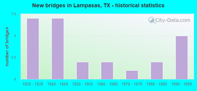
- New bridges - historical statistics
- 71930-1939
- 71940-1949
- 21950-1959
- 21960-1969
- 11970-1979
- 21980-1989
- 51990-1999

- Reconstructed bridges - Historical Statistics
- 31950-1959
- 01960-1969
- 01970-1979
- 41980-1989
- 11990-1999
- 12000-2009


- Bridge Condition - Deck
- 73.3%Good
- 26.7%Satisfactory

- Bridge Condition - Superstructure
- 6.7%Very good
- 40.0%Good
- 53.3%Satisfactory

- Bridge Condition - Substructure
- 53.3%Good
- 40.0%Satisfactory
- 6.7%Fair

- Bridge Condition - Channel
- 62.5%Good
- 37.5%Satisfactory

- Bridge Condition - Culverts
- 80.0%Good
- 20.0%Satisfactory
Find on map >> Show street view
Structure Number: 140270025107058, Location: 3.20 MI S OF US 183 (Lat: 31.014706, Lng: -98.189025), Route carried "on" structure: US 281, Year Built: 1963, Status: Open, Structure Length: 0.67m (2.20ft), Average Daily Traffic: 6,514 (year 2020), Truck Traffic: 10%, Average Future Daily Traffic: 8,300 (year 2033), Design Load: HS 20, Features Intersected: DRAW
Minimum Vertical Clearance: 30+ m (98+ ft), Kilometerpoint: 2.023, Lanes on structure: 4, Owner: State Highway Agency, Approaching Roadway Width: 15.9m (52.2ft), Material/Design: Concrete, Design/Construction: Culvert, Number Of Spans In Main Unit: 2, Length of Maximum Span: 3.0m (9.8ft)
Condition: Channel: Good, Culverts: Good, Operating Rating: 39.9 metric tons, Method Used To Determine Operating Rating: Load Factor (LF), Inventory Rating: 23.6 metric tons, Method Used To Determine Inventory Rating: Load Factor (LF), Structural Evaluation: Somewhat better than minimum adequacy, Waterway Adequacy: Equal to present minimum criteria, Approach Roadway Alignment: Equal to present desirable criteria, Designated Inspection Frequency: Every 24 months, Inspection Date: June 2021
Find on map >> Show street view
Structure Number: 140270027302002, Location: 9.15 MI NW OF RM 963 (Lat: 31.020039, Lng: -98.124778), Route carried "on" structure: US 183, Year Built: 1931, Year Reconstructed: 1958, Status: Open, Structure Length: 6.10m (20.01ft), Average Daily Traffic: 5,247 (year 2020), Truck Traffic: 11%, Average Future Daily Traffic: 4,480 (year 2033), Features Intersected: MESQUITE CREEK
Minimum Vertical Clearance: 30+ m (98+ ft), Kilometerpoint: 2.406, Lanes on structure: 4, Owner: State Highway Agency, Approaching Roadway Width: 13.4m (44.0ft), Material/Design: Concrete, Design/Construction: Slab, Number Of Spans In Main Unit: 10, Length of Maximum Span: 6.1m (20.0ft), Curb-To-Curb Width: 13.4m (44.0ft), Out-to-Out Width: 14.3m (46.9ft)
Condition: Deck: Satisfactory, Superstructure: Satisfactory, Substructure: Satisfactory, Channel: Good, Operating Rating: 42.6 metric tons, Method Used To Determine Operating Rating: Load Factor (LF), Inventory Rating: 25.4 metric tons, Method Used To Determine Inventory Rating: Load Factor (LF), Structural Evaluation: Equal to present minimum criteria, Deck Geometry: High priority of replacement, Waterway Adequacy: Equal to present minimum criteria, Approach Roadway Alignment: Equal to present desirable criteria, Length Of Structure Improvement: 6.10m (20.01ft), Designated Inspection Frequency: Every 24 months, Inspection Date: June 2021, Bridge Improvement Cost: $18,000, Roadway Improvement Cost: $5,000, Total Project Cost: $23,000, Deck Structure Type: Concrete Cast-file-Place, Wearing Surface/Protective System: Wearing Surface: Bituminous
Find on map >> Show street view
Structure Number: 231410023101013, Location: 4.5 MI E OF US 281 (Lat: 31.051803, Lng: -98.113647), Route carried "on" structure: US 190, Year Built: 1938, Year Reconstructed: 1987, Status: Open, Structure Length: 1.46m (4.79ft), Average Daily Traffic: 12,926 (year 2020), Truck Traffic: 5%, Average Future Daily Traffic: 13,890 (year 2033), Design Load: H 15, Features Intersected: COOKSEY CREEK
Minimum Vertical Clearance: 30+ m (98+ ft), Kilometerpoint: 8.050, Lanes on structure: 5, Base Highway Network: Yes, Owner: State Highway Agency, Approaching Roadway Width: 25.0m (82.0ft), Skew: 4 degrees, Material/Design: Concrete, Design/Construction: Culvert, Number Of Spans In Main Unit: 5, Length of Maximum Span: 1.8m (5.9ft), Curb-To-Curb Width: 26.4m (86.6ft), Out-to-Out Width: 28.7m (94.2ft)
Condition: Channel: Good, Culverts: Satisfactory, Operating Rating: 39.9 metric tons, Method Used To Determine Operating Rating: Load Factor (LF), Inventory Rating: 23.6 metric tons, Method Used To Determine Inventory Rating: Load Factor (LF), Structural Evaluation: Somewhat better than minimum adequacy, Deck Geometry: Superior to present desirable criteria, Waterway Adequacy: Better than present minimum criteria, Approach Roadway Alignment: Equal to present desirable criteria, Designated Inspection Frequency: Every 24 months, Inspection Date: November 2021, Deck Structure Type: Concrete Cast-file-Place, Wearing Surface/Protective System: Wearing Surface: Bituminous
Find on map >> Show street view
Structure Number: 23141002310113, Location: 0.15 MI E OF US 183 (Lat: 31.056328, Lng: -98.175864), Route carried "on" structure: US 190, Year Built: 1986, Year Reconstructed: 1993, Status: Open, Structure Length: 0.91m (2.99ft), Average Daily Traffic: 12,172 (year 2020), Truck Traffic: 5%, Average Future Daily Traffic: 15,790 (year 2033), Design Load: HS 20, Features Intersected: DRAIN
Minimum Vertical Clearance: 30+ m (98+ ft), Kilometerpoint: 1.555, Lanes on structure: 4, Base Highway Network: Yes, Owner: State Highway Agency, Approaching Roadway Width: 19.5m (64.0ft), Skew: 4 degrees, Material/Design: Concrete, Design/Construction: Culvert, Number Of Spans In Main Unit: 3, Length of Maximum Span: 1.8m (5.9ft)
Condition: Channel: Satisfactory, Culverts: Good, Operating Rating: 39.9 metric tons, Method Used To Determine Operating Rating: Load Factor (LF), Inventory Rating: 23.6 metric tons, Method Used To Determine Inventory Rating: Load Factor (LF), Structural Evaluation: Somewhat better than minimum adequacy, Waterway Adequacy: Better than present minimum criteria, Approach Roadway Alignment: Equal to present desirable criteria, Designated Inspection Frequency: Every 24 months, Inspection Date: November 2021
Find on map >> Show street view
Structure Number: 231410023101131, Location: 1.40 MI NE OF US 183 (Lat: 31.064947, Lng: -98.158550), Route carried "on" structure: US 190, Year Built: 1938, Year Reconstructed: 1986, Status: Open, Structure Length: 0.73m (2.40ft), Average Daily Traffic: 12,926 (year 2020), Truck Traffic: 5%, Average Future Daily Traffic: 13,890 (year 2033), Design Load: H 15, Features Intersected: GOOCH BRANCH
Minimum Vertical Clearance: 30+ m (98+ ft), Kilometerpoint: 3.449, Lanes on structure: 5, Base Highway Network: Yes, Owner: State Highway Agency, Approaching Roadway Width: 22.6m (74.1ft), Material/Design: Concrete, Design/Construction: Culvert, Number Of Spans In Main Unit: 3, Length of Maximum Span: 2.1m (6.9ft), Curb-To-Curb Width: 22.7m (74.5ft), Out-to-Out Width: 27.5m (90.2ft)
Condition: Channel: Good, Culverts: Good, Operating Rating: 39.9 metric tons, Method Used To Determine Operating Rating: Load Factor (LF), Inventory Rating: 23.6 metric tons, Method Used To Determine Inventory Rating: Load Factor (LF), Structural Evaluation: Somewhat better than minimum adequacy, Deck Geometry: Equal to present minimum criteria, Waterway Adequacy: Better than present minimum criteria, Approach Roadway Alignment: Equal to present desirable criteria, Designated Inspection Frequency: Every 24 months, Inspection Date: November 2021, Deck Structure Type: Concrete Cast-file-Place, Wearing Surface/Protective System: Wearing Surface: Bituminous
Find on map >> Show street view
Structure Number: 231410023115037, Location: 2.40 MI W OF FM 1494 (Lat: 31.083036, Lng: -98.267075), Route carried "on" structure: State highway 580, Year Built: 1947, Status: Open, Structure Length: 2.29m (7.51ft), Average Daily Traffic: 944 (year 2020), Truck Traffic: 22%, Average Future Daily Traffic: 1,207 (year 2038), Design Load: H 15, Features Intersected: DONALSON CREEK
Minimum Vertical Clearance: 30+ m (98+ ft), Kilometerpoint: 29.047, Lanes on structure: 2, Owner: State Highway Agency, Approaching Roadway Width: 6.1m (20.0ft), Material/Design: Concrete, Design/Construction: Slab, Number Of Spans In Main Unit: 3, Length of Maximum Span: 7.6m (24.9ft), Curb-To-Curb Width: 6.9m (22.6ft), Out-to-Out Width: 7.7m (25.3ft)
Condition: Deck: Good, Superstructure: Good, Substructure: Satisfactory, Channel: Good, Operating Rating: 39.9 metric tons, Method Used To Determine Operating Rating: Load Factor (LF), Inventory Rating: 22.7 metric tons, Method Used To Determine Inventory Rating: Load Factor (LF), Structural Evaluation: Equal to present minimum criteria, Deck Geometry: Meets minimum limits, Waterway Adequacy: Equal to present minimum criteria, Approach Roadway Alignment: Equal to present desirable criteria, Designated Inspection Frequency: Every 24 months, Inspection Date: January 2020, Deck Structure Type: Concrete Cast-file-Place, Wearing Surface/Protective System: Wearing Surface: Bituminous
Find on map >> Show street view
Structure Number: 231410023117043, Location: 0.5 MI E OF US 281 (Lat: 31.066103, Lng: -98.173539), Route carried "on" structure: Business State highway 257, Year Built: 1942, Status: Open, Structure Length: 8.44m (27.69ft), Average Daily Traffic: 8,804 (year 2019), Truck Traffic: 13%, Average Future Daily Traffic: 5,010 (year 2033), Design Load: H 20, Features Intersected: SULPHUR CREEK
Minimum Vertical Clearance: 30+ m (98+ ft), Kilometerpoint: 0.787, Lanes on structure: 2, Owner: State Highway Agency, Approaching Roadway Width: 12.2m (40.0ft), Skew: 2 degrees, Material/Design: Concrete, Design/Construction: Tee Beam, Number Of Spans In Main Unit: 6, Number Of Approach Spans: 1, Length of Maximum Span: 12.8m (42.0ft), Curb or Sidewalk Widths: Left: 1.5m (4.9ft), Right: 1.5m (4.9ft), Curb-To-Curb Width: 12.1m (39.7ft), Out-to-Out Width: 15.9m (52.2ft)
Condition: Deck: Good, Superstructure: Satisfactory, Substructure: Satisfactory, Channel: Good, Operating Rating: 44.4 metric tons, Method Used To Determine Operating Rating: Load Factor (LF), Inventory Rating: 32.7 metric tons, Method Used To Determine Inventory Rating: Load Factor (LF), Structural Evaluation: Equal to present minimum criteria, Deck Geometry: Somewhat better than minimum adequacy, Waterway Adequacy: Better than present minimum criteria, Approach Roadway Alignment: Equal to present desirable criteria, Designated Inspection Frequency: Every 24 months, Inspection Date: November 2021, Deck Structure Type: Concrete Cast-file-Place, Wearing Surface/Protective System: Wearing Surface: Bituminous
Find on map >> Show street view
Structure Number: 231410025105027, Location: 2.65 MI N OF US 183 (Lat: 31.119714, Lng: -98.191792), Route carried "on" structure: US 281, Year Built: 1934, Year Reconstructed: 1963, Status: Open, Structure Length: 2.62m (8.60ft), Average Daily Traffic: 3,793 (year 2020), Truck Traffic: 15%, Average Future Daily Traffic: 6,294 (year 2038), Design Load: H 15, Features Intersected: LITTLE LUCY CREEK
Minimum Vertical Clearance: 30+ m (98+ ft), Kilometerpoint: 37.181, Lanes on structure: 2, Base Highway Network: Yes, Owner: State Highway Agency, Approaching Roadway Width: 13.4m (44.0ft), Material/Design: Concrete, Design/Construction: Tee Beam, Number Of Spans In Main Unit: 3, Length of Maximum Span: 8.5m (27.9ft), Curb-To-Curb Width: 13.4m (44.0ft), Out-to-Out Width: 13.8m (45.3ft)
Condition: Deck: Good, Superstructure: Good, Substructure: Good, Channel: Satisfactory, Operating Rating: 44.4 metric tons, Method Used To Determine Operating Rating: Load Factor (LF), Inventory Rating: 32.7 metric tons, Method Used To Determine Inventory Rating: Load Factor (LF), Structural Evaluation: Better than present minimum criteria, Deck Geometry: Better than present minimum criteria, Waterway Adequacy: Equal to present minimum criteria, Approach Roadway Alignment: Equal to present desirable criteria, Designated Inspection Frequency: Every 24 months, Inspection Date: January 2020, Deck Structure Type: Concrete Cast-file-Place, Wearing Surface/Protective System: Wearing Surface: Bituminous
Find on map >> Show street view
Structure Number: 231410025105028, Location: 2.35 MI N OF US 183 (Lat: 31.115558, Lng: -98.193844), Route carried "on" structure: US 281, Year Built: 1934, Year Reconstructed: 1963, Status: Open, Structure Length: 4.79m (15.72ft), Average Daily Traffic: 3,793 (year 2020), Truck Traffic: 15%, Average Future Daily Traffic: 6,294 (year 2038), Design Load: H 15, Features Intersected: AT&SF RAILROAD
Minimum Vertical Clearance: 30+ m (98+ ft), Kilometerpoint: 37.689, Lanes on structure: 2, Base Highway Network: Yes, Owner: State Highway Agency, Approaching Roadway Width: 12.8m (42.0ft), Skew: 9 degrees, Material/Design: Steel, Design/Construction: Stringer/Multi-beam, Number Of Spans In Main Unit: 3, Length of Maximum Span: 15.9m (52.2ft), Curb-To-Curb Width: 13.0m (42.7ft), Out-to-Out Width: 13.5m (44.3ft)
Condition: Deck: Satisfactory, Superstructure: Satisfactory, Substructure: Good, Operating Rating: 35.4 metric tons, Method Used To Determine Operating Rating: Load Factor (LF), Inventory Rating: 20.9 metric tons, Method Used To Determine Inventory Rating: Load Factor (LF), Structural Evaluation: Somewhat better than minimum adequacy, Deck Geometry: Equal to present minimum criteria, Underclear: Meets minimum limits, Approach Roadway Alignment: Equal to present desirable criteria, Designated Inspection Frequency: Every 24 months, Inspection Date: January 2020, Deck Structure Type: Concrete Cast-file-Place, Wearing Surface/Protective System: Wearing Surface: Bituminous
Find on map >> Show street view
Structure Number: 231410025105063, Location: 6.00 MI S OF FM 1690 (Lat: 31.140161, Lng: -98.184847), Route carried "on" structure: US 281, Year Built: 1970, Status: Open, Structure Length: 0.88m (2.89ft), Average Daily Traffic: 3,793 (year 2020), Truck Traffic: 15%, Average Future Daily Traffic: 6,294 (year 2038), Design Load: HS 20, Features Intersected: LITTLE LUCY CREEK TRIB
Minimum Vertical Clearance: 30+ m (98+ ft), Kilometerpoint: 34.833, Lanes on structure: 3, Base Highway Network: Yes, Owner: State Highway Agency, Approaching Roadway Width: 12.8m (42.0ft), Skew: 4 degrees, Material/Design: Concrete, Design/Construction: Culvert, Number Of Spans In Main Unit: 3, Length of Maximum Span: 1.8m (5.9ft), Out-to-Out Width: 48.6m (159.4ft)
Condition: Channel: Good, Culverts: Good, Operating Rating: 39.9 metric tons, Method Used To Determine Operating Rating: Load Factor (LF), Inventory Rating: 23.6 metric tons, Method Used To Determine Inventory Rating: Load Factor (LF), Structural Evaluation: Equal to present minimum criteria, Waterway Adequacy: Equal to present minimum criteria, Approach Roadway Alignment: Equal to present desirable criteria, Designated Inspection Frequency: Every 24 months, Inspection Date: January 2020
Find on map >> Show street view
Structure Number: 231410025105064, Location: 0.00 MI S OF FM 580 N (Lat: 31.076017, Lng: -98.186219), Route carried "on" structure: US 183, Year Built: 1995, Status: Open, Structure Length: 2.77m (9.09ft), Average Daily Traffic: 13,589 (year 2019), Truck Traffic: 10%, Average Future Daily Traffic: 15,710 (year 2033), Design Load: HS 20, Features Intersected: BURLESON CREEK, Facility Carried by Structure: US 281
Minimum Vertical Clearance: 30+ m (98+ ft), Kilometerpoint: 41.684, Lanes on structure: 5, Base Highway Network: Yes, Owner: State Highway Agency, Approaching Roadway Width: 21.9m (71.9ft), Material/Design: Concrete, Design/Construction: Stringer/Multi-beam, Number Of Spans In Main Unit: 3, Length of Maximum Span: 9.1m (29.9ft), Curb or Sidewalk Widths: Left: 1.8m (5.9ft), Right: 1.8m (5.9ft), Curb-To-Curb Width: 23.8m (78.1ft), Out-to-Out Width: 28.0m (91.9ft)
Condition: Deck: Good, Superstructure: Good, Substructure: Good, Channel: Satisfactory, Operating Rating: 54.4 metric tons, Method Used To Determine Operating Rating: Assigned rating based on Load Factor Design (LFD) reported in metric tons, Inventory Rating: 32.7 metric tons, Method Used To Determine Inventory Rating: Assigned rating based on Load Factor Design (LFD) reported in metric tons, Structural Evaluation: Better than present minimum criteria, Deck Geometry: Better than present minimum criteria, Waterway Adequacy: Superior to present desirable criteria, Approach Roadway Alignment: Equal to present desirable criteria, Designated Inspection Frequency: Every 24 months, Inspection Date: January 2020, Deck Structure Type: Concrete Cast-file-Place
Find on map >> Show street view
Structure Number: 231410025106029, Location: 0.30 MI S OF US 183 S (Lat: 31.055447, Lng: -98.182128), Route carried "on" structure: US 281, Year Built: 1934, Status: Open, Structure Length: 6.83m (22.41ft), Average Daily Traffic: 4,971 (year 2020), Truck Traffic: 18%, Average Future Daily Traffic: 8,470 (year 2030), Design Load: H 15, Features Intersected: SULPHUR CREEK
Minimum Vertical Clearance: 30+ m (98+ ft), Kilometerpoint: 44.635, Lanes on structure: 2, Base Highway Network: Yes, Owner: State Highway Agency, Approaching Roadway Width: 9.1m (29.9ft), Material/Design: Steel continuous, Design/Construction: Stringer/Multi-beam, Number Of Spans In Main Unit: 3, Length of Maximum Span: 20.4m (66.9ft), Curb-To-Curb Width: 9.1m (29.9ft), Out-to-Out Width: 10.2m (33.5ft)
Condition: Deck: Good, Superstructure: Satisfactory, Substructure: Satisfactory, Channel: Good, Operating Rating: 39.0 metric tons, Method Used To Determine Operating Rating: Load Factor (LF), Inventory Rating: 23.6 metric tons, Method Used To Determine Inventory Rating: Load Factor (LF), Structural Evaluation: Equal to present minimum criteria, Deck Geometry: Meets minimum limits, Waterway Adequacy: Equal to present minimum criteria, Approach Roadway Alignment: Equal to present desirable criteria, Designated Inspection Frequency: Every 24 months, Inspection Date: October 2021, Deck Structure Type: Concrete Cast-file-Place, Wearing Surface/Protective System: Wearing Surface: Bituminous
Find on map >> Show street view
Structure Number: 23141002510603, Location: 1.35 MI S OF US 183 S (Lat: 31.041369, Lng: -98.180475), Route carried "on" structure: US 281, Year Built: 1934, Year Reconstructed: 2009, Status: Open, Structure Length: 0.64m (2.10ft), Average Daily Traffic: 7,467 (year 2020), Truck Traffic: 17%, Average Future Daily Traffic: 11,005 (year 2038), Design Load: H 15, Features Intersected: SULPHUR CREEK TRIBUTARY
Minimum Vertical Clearance: 30+ m (98+ ft), Kilometerpoint: 46.254, Lanes on structure: 5, Base Highway Network: Yes, Owner: State Highway Agency, Approaching Roadway Width: 26.5m (86.9ft), Skew: 9 degrees, Material/Design: Concrete, Design/Construction: Culvert, Number Of Spans In Main Unit: 2, Length of Maximum Span: 3.0m (9.8ft), Curb-To-Curb Width: 33.0m (108.3ft), Out-to-Out Width: 33.6m (110.2ft)
Condition: Channel: Good, Culverts: Satisfactory, Operating Rating: 39.9 metric tons, Method Used To Determine Operating Rating: Load Factor (LF), Inventory Rating: 23.6 metric tons, Method Used To Determine Inventory Rating: Load Factor (LF), Structural Evaluation: Somewhat better than minimum adequacy, Deck Geometry: Superior to present desirable criteria, Waterway Adequacy: Equal to present minimum criteria, Approach Roadway Alignment: Equal to present desirable criteria, Designated Inspection Frequency: Every 24 months, Inspection Date: January 2020, Deck Structure Type: Concrete Cast-file-Place, Wearing Surface/Protective System: Wearing Surface: Bituminous
Find on map >> Show street view
Structure Number: 231410027301012, Location: 0.15 MI N OF US 190 (Lat: 31.057594, Lng: -98.179500), Route carried "on" structure: US 183, Year Built: 1949, Year Reconstructed: 1991, Status: Open, Structure Length: 8.53m (27.99ft), Average Daily Traffic: 12,133 (year 2020), Truck Traffic: 8%, Average Future Daily Traffic: 20,000 (year 2033), Design Load: HS 20, Features Intersected: SULPHUR CREEK
Minimum Vertical Clearance: 30+ m (98+ ft), Kilometerpoint: 0.192, Lanes on structure: 5, Lanes under structure: 2, Base Highway Network: Yes, Owner: State Highway Agency, Approaching Roadway Width: 21.9m (71.9ft), Skew: 3 degrees, Material/Design: Steel continuous, Design/Construction: Stringer/Multi-beam, Number Of Spans In Main Unit: 4, Length of Maximum Span: 27.4m (89.9ft), Curb or Sidewalk Widths: Left: 1.8m (5.9ft), Right: 1.8m (5.9ft), Curb-To-Curb Width: 21.9m (71.9ft), Out-to-Out Width: 26.2m (86.0ft)
Condition: Deck: Good, Superstructure: Satisfactory, Substructure: Satisfactory, Channel: Good, Operating Rating: 54.4 metric tons, Method Used To Determine Operating Rating: Assigned rating based on Load Factor Design (LFD) reported in metric tons, Inventory Rating: 32.7 metric tons, Method Used To Determine Inventory Rating: Assigned rating based on Load Factor Design (LFD) reported in metric tons, Structural Evaluation: Equal to present minimum criteria, Deck Geometry: Somewhat better than minimum adequacy, Underclear: High priority of corrective action, Waterway Adequacy: Superior to present desirable criteria, Approach Roadway Alignment: Equal to present desirable criteria, Length Of Structure Improvement: 8.53m (27.99ft), Designated Inspection Frequency: Every 24 months, Inspection Date: October 2021, Bridge Improvement Cost: $40,000, Roadway Improvement Cost: $10,000, Total Project Cost: $50,000, Deck Structure Type: Concrete Cast-file-Place, Wearing Surface/Protective System: Wearing Surface: Bituminous
Find on map >> Show street view
Structure Number: 231410103201017, Location: 0.80 MI E OF US 183 (Lat: 31.079753, Lng: -98.173461), Route carried "on" structure: State highway 580, Year Built: 1966, Year Reconstructed: 1996, Status: Open, Structure Length: 1.07m (3.51ft), Average Daily Traffic: 3,004 (year 2020), Truck Traffic: 12%, Average Future Daily Traffic: 4,221 (year 2038), Design Load: HS 20, Features Intersected: GIBSON CREEK
Minimum Vertical Clearance: 30+ m (98+ ft), Kilometerpoint: 1.730, Lanes on structure: 2, Owner: State Highway Agency, Approaching Roadway Width: 13.4m (44.0ft), Material/Design: Concrete, Design/Construction: Culvert, Number Of Spans In Main Unit: 4, Length of Maximum Span: 2.4m (7.9ft), Curb or Sidewalk Widths: Left: 1.8m (5.9ft), Right: 1.8m (5.9ft), Curb-To-Curb Width: 13.3m (43.6ft), Out-to-Out Width: 17.7m (58.1ft)
Condition: Channel: Satisfactory, Culverts: Good, Operating Rating: 39.9 metric tons, Method Used To Determine Operating Rating: Load Factor (LF), Inventory Rating: 23.6 metric tons, Method Used To Determine Inventory Rating: Load Factor (LF), Structural Evaluation: Equal to present minimum criteria, Deck Geometry: Equal to present minimum criteria, Waterway Adequacy: Equal to present minimum criteria, Approach Roadway Alignment: Equal to present desirable criteria, Designated Inspection Frequency: Every 24 months, Inspection Date: January 2020, Deck Structure Type: Concrete Cast-file-Place, Wearing Surface/Protective System: Wearing Surface: Bituminous
Find on map >> Show street view
Structure Number: 231410103201019, Location: 1.75 MI E OF US 183 (Lat: 31.087281, Lng: -98.162200), Route carried "on" structure: State highway 580, Year Built: 1996, Status: Open, Structure Length: 0.67m (2.20ft), Average Daily Traffic: 2,520 (year 2020), Truck Traffic: 11%, Average Future Daily Traffic: 3,410 (year 2033), Design Load: HS 20, Features Intersected: DRAW
Minimum Vertical Clearance: 30+ m (98+ ft), Kilometerpoint: 3.211, Lanes on structure: 2, Owner: State Highway Agency, Approaching Roadway Width: 12.2m (40.0ft), Skew: 3 degrees, Material/Design: Concrete, Design/Construction: Culvert, Number Of Spans In Main Unit: 3, Length of Maximum Span: 1.8m (5.9ft), Out-to-Out Width: 26.5m (86.9ft)
Condition: Channel: Satisfactory, Culverts: Good, Operating Rating: 39.9 metric tons, Method Used To Determine Operating Rating: Load Factor (LF), Inventory Rating: 23.6 metric tons, Method Used To Determine Inventory Rating: Load Factor (LF), Structural Evaluation: Equal to present minimum criteria, Waterway Adequacy: Equal to present minimum criteria, Approach Roadway Alignment: Equal to present desirable criteria, Designated Inspection Frequency: Every 48 months, Inspection Date: January 2020
Find on map >> Show street view
Structure Number: 231410103203007, Location: 1.05 MI S OF FM 580 (Lat: 31.050072, Lng: -98.189844), Route carried "on" structure: State highway 1478, Year Built: 1941, Status: Open, Structure Length: 0.64m (2.10ft), Average Daily Traffic: 1,397 (year 2020), Truck Traffic: 5%, Average Future Daily Traffic: 1,997 (year 2038), Features Intersected: DRAW
Minimum Vertical Clearance: 30+ m (98+ ft), Kilometerpoint: 17.477, Lanes on structure: 2, Owner: State Highway Agency, Approaching Roadway Width: 6.4m (21.0ft), Skew: 1 degrees, Material/Design: Concrete, Design/Construction: Culvert, Number Of Spans In Main Unit: 2, Length of Maximum Span: 3.0m (9.8ft), Curb-To-Curb Width: 8.4m (27.6ft), Out-to-Out Width: 8.8m (28.9ft)
Condition: Channel: Good, Culverts: Good, Operating Rating: 32.7 metric tons, Method Used To Determine Operating Rating: Field evaluation and documented engineering judgment, Inventory Rating: 24.5 metric tons, Method Used To Determine Inventory Rating: Field evaluation and documented engineering judgment, Structural Evaluation: Equal to present minimum criteria, Deck Geometry: Meets minimum limits, Waterway Adequacy: Equal to present minimum criteria, Approach Roadway Alignment: Equal to present desirable criteria, Designated Inspection Frequency: Every 24 months, Inspection Date: January 2020, Deck Structure Type: Concrete Cast-file-Place, Wearing Surface/Protective System: Wearing Surface: Bituminous
Find on map >> Show street view
Structure Number: 231410103203011, Location: 0.80 MI NE OF BURNET C/L (Lat: 31.035753, Lng: -98.213708), Route carried "on" structure: State highway 1478, Year Built: 1959, Status: Open, Structure Length: 3.81m (12.50ft), Average Daily Traffic: 688 (year 2020), Truck Traffic: 6%, Average Future Daily Traffic: 1,134 (year 2038), Features Intersected: SULPHUR CREEK
Minimum Vertical Clearance: 30+ m (98+ ft), Kilometerpoint: 20.410, Lanes on structure: 2, Owner: State Highway Agency, Approaching Roadway Width: 6.1m (20.0ft), Skew: 2 degrees, Material/Design: Concrete, Design/Construction: Stringer/Multi-beam, Number Of Spans In Main Unit: 3, Length of Maximum Span: 12.8m (42.0ft), Curb-To-Curb Width: 7.2m (23.6ft), Out-to-Out Width: 7.5m (24.6ft)
Condition: Deck: Good, Superstructure: Satisfactory, Substructure: Good, Channel: Satisfactory, Operating Rating: 44.4 metric tons, Method Used To Determine Operating Rating: Load Factor (LF), Inventory Rating: 31.7 metric tons, Method Used To Determine Inventory Rating: Load Factor (LF), Structural Evaluation: Equal to present minimum criteria, Deck Geometry: Meets minimum limits, Waterway Adequacy: Equal to present minimum criteria, Approach Roadway Alignment: Equal to present desirable criteria, Length Of Structure Improvement: 3.81m (12.50ft), Designated Inspection Frequency: Every 24 months, Inspection Date: January 2020, Bridge Improvement Cost: $6,000, Roadway Improvement Cost: $2,000, Total Project Cost: $8,000, Deck Structure Type: Concrete Cast-file-Place, Wearing Surface/Protective System: Wearing Surface: Bituminous
Find on map >> Show street view
Structure Number: 231410103203012, Location: 0.20 MI NE OF BURNET C/L (Lat: 31.032828, Lng: -98.222328), Route carried "on" structure: State highway 1478, Year Built: 1959, Status: Open, Structure Length: 2.53m (8.30ft), Average Daily Traffic: 688 (year 2020), Truck Traffic: 6%, Average Future Daily Traffic: 1,134 (year 2038), Features Intersected: BLUFF CREEK
Minimum Vertical Clearance: 30+ m (98+ ft), Kilometerpoint: 21.311, Lanes on structure: 2, Owner: State Highway Agency, Approaching Roadway Width: 6.1m (20.0ft), Skew: 2 degrees, Material/Design: Concrete, Design/Construction: Stringer/Multi-beam, Number Of Spans In Main Unit: 2, Length of Maximum Span: 12.8m (42.0ft), Curb-To-Curb Width: 7.2m (23.6ft), Out-to-Out Width: 7.5m (24.6ft)
Condition: Deck: Good, Superstructure: Good, Substructure: Good, Channel: Good, Operating Rating: 44.4 metric tons, Method Used To Determine Operating Rating: Load Factor (LF), Inventory Rating: 31.7 metric tons, Method Used To Determine Inventory Rating: Load Factor (LF), Structural Evaluation: Better than present minimum criteria, Deck Geometry: Meets minimum limits, Waterway Adequacy: Equal to present minimum criteria, Approach Roadway Alignment: Equal to present desirable criteria, Length Of Structure Improvement: 2.53m (8.30ft), Designated Inspection Frequency: Every 24 months, Inspection Date: January 2020, Bridge Improvement Cost: $4,000, Roadway Improvement Cost: $1,000, Total Project Cost: $5,000, Deck Structure Type: Concrete Cast-file-Place, Wearing Surface/Protective System: Wearing Surface: Bituminous
Find on map >> Show street view
Structure Number: 231410AA0006001, Location: 1.40 MI SE OF FM 580 (Lat: 31.073406, Lng: -98.134592), Route carried "on" structure: County highway 3040, Year Built: 1999, Status: Open, Structure Length: 1.89m (6.20ft), Average Daily Traffic: 110 (year 2013), Average Future Daily Traffic: 50 (year 2033), Design Load: HS 20, Features Intersected: PECAN BRANCH
Minimum Vertical Clearance: 30+ m (98+ ft), Kilometerpoint: 2.414, Lanes on structure: 2, Owner: County Highway Agency, Approaching Roadway Width: 5.7m (18.7ft), Skew: 1 degrees, Material/Design: Concrete, Design/Construction: Stringer/Multi-beam, Number Of Spans In Main Unit: 2, Length of Maximum Span: 9.4m (30.8ft), Curb-To-Curb Width: 7.1m (23.3ft), Out-to-Out Width: 7.8m (25.6ft)
Condition: Deck: Good, Superstructure: Good, Substructure: Good, Channel: Good, Operating Rating: 54.4 metric tons, Method Used To Determine Operating Rating: Assigned rating based on Load Factor Design (LFD) reported in metric tons, Inventory Rating: 32.7 metric tons, Method Used To Determine Inventory Rating: Assigned rating based on Load Factor Design (LFD) reported in metric tons, Structural Evaluation: Better than present minimum criteria, Deck Geometry: Meets minimum limits, Waterway Adequacy: Better than present minimum criteria, Approach Roadway Alignment: Equal to present desirable criteria, Designated Inspection Frequency: Every 24 months, Inspection Date: January 2021, Deck Structure Type: Concrete Cast-file-Place, Wearing Surface/Protective System: Wearing Surface: Bituminous
Find on map >> Show street view
Structure Number: 231410AA0041001, Location: 1.80 MI SE OF US 183/190 (Lat: 31.083539, Lng: -98.200217), Route carried "on" structure: County highway 1045, Year Built: 1999, Status: Open, Structure Length: 1.59m (5.22ft), Average Daily Traffic: 515 (year 2017), Truck Traffic: 5%, Average Future Daily Traffic: 500 (year 2033), Design Load: HS 20, Features Intersected: BURLESON CREEK
Minimum Vertical Clearance: 30+ m (98+ ft), Kilometerpoint: 1.046, Lanes on structure: 2, Owner: County Highway Agency, Approaching Roadway Width: 7.0m (23.0ft), Skew: 1 degrees, Material/Design: Steel, Design/Construction: Culvert, Number Of Spans In Main Unit: 2, Length of Maximum Span: 7.0m (23.0ft)
Condition: Channel: Good, Culverts: Good, Operating Rating: 39.9 metric tons, Method Used To Determine Operating Rating: Load Factor (LF), Inventory Rating: 23.6 metric tons, Method Used To Determine Inventory Rating: Load Factor (LF), Structural Evaluation: Equal to present minimum criteria, Waterway Adequacy: Better than present minimum criteria, Approach Roadway Alignment: Equal to present desirable criteria, Designated Inspection Frequency: Every 24 months, Inspection Date: January 2021
Find on map >> Show street view
Structure Number: 231410B00610001, Location: 0.90 MI N OF US 190 (Lat: 31.070031, Lng: -98.181100), Route carried "on" structure: City street , Year Built: 1982, Status: Open, Structure Length: 2.44m (8.01ft), Average Daily Traffic: 1,381 (year 2017), Truck Traffic: 2%, Average Future Daily Traffic: 1,000 (year 2033), Design Load: H 15, Features Intersected: BURLESON CREEK, Facility Carried by Structure: WESTERN AVE.
Minimum Vertical Clearance: 30+ m (98+ ft), Kilometerpoint: 1.046, Lanes on structure: 2, Owner: City or Municipal Highway Agency, Approaching Roadway Width: 7.6m (24.9ft), Material/Design: Concrete, Design/Construction: Stringer/Multi-beam, Number Of Spans In Main Unit: 2, Length of Maximum Span: 12.2m (40.0ft), Curb-To-Curb Width: 7.9m (25.9ft), Out-to-Out Width: 8.6m (28.2ft)
Condition: Deck: Good, Superstructure: Good, Substructure: Good, Channel: Satisfactory, Operating Rating: 45.4 metric tons, Method Used To Determine Operating Rating: Load Factor (LF), Inventory Rating: 27.2 metric tons, Method Used To Determine Inventory Rating: Load Factor (LF), Structural Evaluation: Equal to present minimum criteria, Deck Geometry: Meets minimum limits, Waterway Adequacy: Equal to present minimum criteria, Approach Roadway Alignment: Equal to present desirable criteria, Length Of Structure Improvement: 2.44m (8.01ft), Designated Inspection Frequency: Every 24 months, Inspection Date: January 2021, Total Project Cost: $45,000, Deck Structure Type: Concrete Cast-file-Place
Find on map >> Show street view
Structure Number: 231410B00610002, Location: 0.20 MI N OF US 190 (Lat: 31.059775, Lng: -98.177039), Route carried "on" structure: City street 908, Year Built: 1992, Status: Open, Structure Length: 7.92m (25.98ft), Average Daily Traffic: 2,900 (year 2013), Average Future Daily Traffic: 3,500 (year 2033), Design Load: HS 20, Features Intersected: SULPHUR CREEK, Facility Carried by Structure: WESTERN AVE.
Minimum Vertical Clearance: 30+ m (98+ ft), Kilometerpoint: 0.354, Lanes on structure: 2, Owner: City or Municipal Highway Agency, Approaching Roadway Width: 13.4m (44.0ft), Skew: 3 degrees, Material/Design: Prestressed concrete, Design/Construction: Stringer/Multi-beam, Number Of Spans In Main Unit: 3, Length of Maximum Span: 33.5m (109.9ft), Curb or Sidewalk Widths: Left: 1.8m (5.9ft), Right: 1.8m (5.9ft), Curb-To-Curb Width: 13.4m (44.0ft), Out-to-Out Width: 17.8m (58.4ft)
Condition: Deck: Good, Superstructure: Very good, Substructure: Good, Channel: Good, Operating Rating: 54.4 metric tons, Method Used To Determine Operating Rating: Assigned rating based on Load Factor Design (LFD) reported in metric tons, Inventory Rating: 32.7 metric tons, Method Used To Determine Inventory Rating: Assigned rating based on Load Factor Design (LFD) reported in metric tons, Structural Evaluation: Better than present minimum criteria, Deck Geometry: Better than present minimum criteria, Waterway Adequacy: Superior to present desirable criteria, Approach Roadway Alignment: Equal to present desirable criteria, Designated Inspection Frequency: Every 24 months, Inspection Date: January 2021, Deck Structure Type: Concrete Precast Panels
Find on map >> Show street view
Structure Number: 231410B00645001, Location: 0.60 MI NE OF US 183 (Lat: 31.068808, Lng: -98.172767), Route carried "on" structure: City street 905, Year Built: 1948, Status: Open, Structure Length: 1.83m (6.00ft), Average Daily Traffic: 2,900 (year 2013), Average Future Daily Traffic: 3,500 (year 2033), Design Load: H 15, Features Intersected: BURLESON CREEK, Facility Carried by Structure: THIRD ST
Minimum Vertical Clearance: 30+ m (98+ ft), Kilometerpoint: 0.966, Lanes on structure: 2, Owner: City or Municipal Highway Agency, Approaching Roadway Width: 6.7m (22.0ft), Material/Design: Concrete, Design/Construction: Slab, Number Of Spans In Main Unit: 3, Length of Maximum Span: 6.1m (20.0ft), Curb-To-Curb Width: 6.5m (21.3ft), Out-to-Out Width: 7.1m (23.3ft)
Condition: Deck: Satisfactory, Superstructure: Satisfactory, Substructure: Fair, Channel: Satisfactory, Operating Rating: 32.7 metric tons, Method Used To Determine Operating Rating: Field evaluation and documented engineering judgment, Inventory Rating: 20.9 metric tons, Method Used To Determine Inventory Rating: Load Factor (LF), Structural Evaluation: Somewhat better than minimum adequacy, Deck Geometry: High priority of replacement, Waterway Adequacy: Equal to present minimum criteria, Approach Roadway Alignment: Somewhat better than minimum adequacy, Length Of Structure Improvement: 1.83m (6.00ft), Designated Inspection Frequency: Every 24 months, Inspection Date: January 2021, Bridge Improvement Cost: $26,000, Roadway Improvement Cost: $7,000, Total Project Cost: $33,000, Deck Structure Type: Concrete Cast-file-Place
Find on map >> Show street view
Structure Number: 231410B00645002, Location: 0.90 MI NE OF US 183 (Lat: 31.073372, Lng: -98.170733), Route carried "on" structure: City street 905, Year Built: 1948, Status: Open, Structure Length: 1.52m (4.99ft), Average Daily Traffic: 1,171 (year 2017), Average Future Daily Traffic: 3,500 (year 2033), Design Load: H 15, Features Intersected: GIBSON BRANCH, Facility Carried by Structure: THIRD ST
Minimum Vertical Clearance: 30+ m (98+ ft), Kilometerpoint: 1.448, Lanes on structure: 2, Owner: City or Municipal Highway Agency, Approaching Roadway Width: 6.4m (21.0ft), Material/Design: Concrete, Design/Construction: Slab, Number Of Spans In Main Unit: 2, Length of Maximum Span: 7.6m (24.9ft), Curb-To-Curb Width: 6.5m (21.3ft), Out-to-Out Width: 7.1m (23.3ft)
Condition: Deck: Satisfactory, Superstructure: Satisfactory, Substructure: Satisfactory, Channel: Satisfactory, Operating Rating: 43.5 metric tons, Method Used To Determine Operating Rating: Load Factor (LF), Inventory Rating: 21.8 metric tons, Method Used To Determine Inventory Rating: Load Factor (LF), Structural Evaluation: Somewhat better than minimum adequacy, Deck Geometry: High priority of replacement, Waterway Adequacy: Equal to present minimum criteria, Approach Roadway Alignment: Equal to present desirable criteria, Length Of Structure Improvement: 1.52m (4.99ft), Designated Inspection Frequency: Every 24 months, Inspection Date: January 2021, Bridge Improvement Cost: $21,000, Roadway Improvement Cost: $5,000, Total Project Cost: $26,000, Deck Structure Type: Concrete Cast-file-Place
Find on map >> Show street view
Structure Number: 231410027301012, Location: 0.15 MI N OF US 190 (Lat: 31.057594, Lng: -98.179500), Route carried "under" structure: Other road 183, Year Built: 1949, Structure Length: 0. m, Average Daily Traffic: 50 (year 2010), Features Intersected: Park Rd
Minimum Vertical Clearance: 30+ m (98+ ft), Kilometerpoint: 0.354, Lanes on structure: 5, Lanes under structure: 2, Material/Design: Steel continuous, Design/Construction: Stringer/Multi-beam, Length of Maximum Span: 27.4m (89.9ft)