Bridge Statistics for Lancaster, Missouri (MO)
Condition, Traffic, Stress, Structural Evaluation, Project Costs
- National Bridge Inventory (NBI) Statistics
- 21Number of bridges
- 138ft / 42.5mTotal length
- $1,475,000Total costs
- 20,704Total average daily traffic
- 5,459Total average daily truck traffic
- 33,799Total future (year 2040) average daily traffic
- National Bridge Inventory (NBI) Registered Bridges for Lancaster
- No street view available for this location
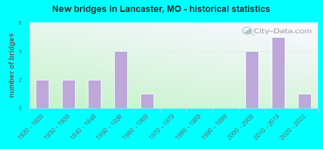
- New bridges - historical statistics
- 21920-1929
- 21930-1939
- 21940-1949
- 41950-1959
- 11960-1969
- 42000-2009
- 52010-2019
- 12020-2022


- Bridge Condition - Deck
- 14.3%Excellent
- 28.6%Very good
- 28.6%Good
- 7.1%Satisfactory
- 7.1%Fair
- 14.3%Serious

- Bridge Condition - Superstructure
- 21.4%Excellent
- 28.6%Very good
- 14.3%Good
- 21.4%Satisfactory
- 7.1%Fair
- 7.1%Poor

- Bridge Condition - Substructure
- 21.4%Excellent
- 42.9%Very good
- 7.1%Good
- 21.4%Satisfactory
- 7.1%Fair

- Bridge Condition - Channel
- 4.8%Excellent
- 9.5%Very good
- 9.5%Good
- 42.9%Satisfactory
- 33.3%Fair

- Bridge Condition - Culverts
- 57.1%Satisfactory
- 42.9%Fair
Find on map >> Show street view
Structure Number: 25098, Location: S 13 T 60 N R 29 W (Lat: 40.014772, Lng: -94.110344), Route carried "on" structure: County highway 625, Year Built: 1962, Status: Open, Structure Length: 0.82m (2.69ft), Average Daily Traffic: 15 (year 2021), Truck Traffic: 10%, Average Future Daily Traffic: 17 (year 2041), Design Load: H 15, Features Intersected: PENHOOK BR, Facility Carried by Structure: IVORY AVE
Minimum Vertical Clearance: 30+ m (98+ ft), Kilometerpoint: 0.966, Lanes on structure: 2, Owner: County Highway Agency, Approaching Roadway Width: 6.1m (20.0ft), Material/Design: Concrete, Design/Construction: Culvert, Number Of Spans In Main Unit: 2, Length of Maximum Span: 3.7m (12.1ft), Curb-To-Curb Width: 7.3m (24.0ft), Out-to-Out Width: 7.3m (24.0ft)
Condition: Channel: Fair, Culverts: Fair, Operating Rating: 51.3 metric tons, Method Used To Determine Operating Rating: Allowable Stress (AS), Inventory Rating: 17.1 metric tons, Method Used To Determine Inventory Rating: Allowable Stress (AS), Structural Evaluation: Somewhat better than minimum adequacy, Deck Geometry: Equal to present minimum criteria, Waterway Adequacy: Better than present minimum criteria, Approach Roadway Alignment: Equal to present desirable criteria, Designated Inspection Frequency: Every 24 months, Inspection Date: Febuary 2022
Find on map >> Show street view
Structure Number: 28556, Location: S 34 T 67 N R 15 W (Lat: 40.574611, Lng: -92.559125), Route carried "on" structure: County highway 40, Year Built: 2001, Status: Open, Structure Length: 2.47m (8.10ft), Average Daily Traffic: 15 (year 2020), Truck Traffic: 10%, Average Future Daily Traffic: 17 (year 2040), Features Intersected: S FK OF N FABIUS R, Facility Carried by Structure: CEDER CREEK LN
Minimum Vertical Clearance: 30+ m (98+ ft), Kilometerpoint: 2.092, Lanes on structure: 2, Owner: County Highway Agency, Approaching Roadway Width: 4.9m (16.1ft), Material/Design: Steel, Design/Construction: Stringer/Multi-beam, Number Of Spans In Main Unit: 2, Length of Maximum Span: 18.0m (59.1ft), Curb-To-Curb Width: 4.9m (16.1ft), Out-to-Out Width: 4.9m (16.1ft)
Condition: Deck: Good, Superstructure: Good, Substructure: Very good, Channel: Satisfactory, Operating Rating: 82.8 metric tons, Method Used To Determine Operating Rating: Load Factor (LF), Inventory Rating: 49.5 metric tons, Method Used To Determine Inventory Rating: Load Factor (LF), Structural Evaluation: Better than present minimum criteria, Deck Geometry: High priority of corrective action, Waterway Adequacy: Equal to present minimum criteria, Approach Roadway Alignment: Equal to present desirable criteria, Designated Inspection Frequency: Every 24 months, Inspection Date: Febuary 2020, Deck Structure Type: Concrete Cast-file-Place
Find on map >> Show street view
Structure Number: 28634, Location: S 6 T 65 N R 14 W (Lat: 40.461611, Lng: -92.514944), Route carried "on" structure: County highway 160, Year Built: 2001, Status: Open, Structure Length: 1.55m (5.09ft), Average Daily Traffic: 15 (year 2020), Truck Traffic: 10%, Average Future Daily Traffic: 17 (year 2040), Features Intersected: FK OF MID FABIUS R
Minimum Vertical Clearance: 30+ m (98+ ft), Kilometerpoint: 1.770, Lanes on structure: 2, Owner: County Highway Agency, Approaching Roadway Width: 5.5m (18.0ft), Material/Design: Steel, Design/Construction: Stringer/Multi-beam, Number Of Spans In Main Unit: 1, Length of Maximum Span: 14.9m (48.9ft), Curb-To-Curb Width: 4.9m (16.1ft), Out-to-Out Width: 4.9m (16.1ft)
Condition: Deck: Good, Superstructure: Very good, Substructure: Very good, Channel: Good, Operating Rating: 54.9 metric tons, Method Used To Determine Operating Rating: Load Factor (LF), Inventory Rating: 33.3 metric tons, Method Used To Determine Inventory Rating: Load Factor (LF), Structural Evaluation: Equal to present desirable criteria, Deck Geometry: High priority of corrective action, Waterway Adequacy: Equal to present minimum criteria, Approach Roadway Alignment: Equal to present desirable criteria, Designated Inspection Frequency: Every 24 months, Inspection Date: Febuary 2020, Deck Structure Type: Concrete Cast-file-Place
Find on map >> Show street view
Structure Number: 29461, Location: S 1 T 66 N R 15 W (Lat: 40.560892, Lng: -92.524519), Route carried "on" structure: US 63, Year Built: 2003, Status: Open, Structure Length: 5.06m (16.60ft), Average Daily Traffic: 2,088 (year 2021), Truck Traffic: 31%, Average Future Daily Traffic: 3,654 (year 2041), Design Load: HS 20, Features Intersected: S FK OF N FABIUS R
Minimum Vertical Clearance: 30+ m (98+ ft), Kilometerpoint: 3.687, Lanes on structure: 2, Base Highway Network: Yes, Owner: State Highway Agency, Approaching Roadway Width: 13.4m (44.0ft), Material/Design: Prestressed concrete continuous, Design/Construction: Stringer/Multi-beam, Number Of Spans In Main Unit: 3, Length of Maximum Span: 19.8m (65.0ft), Curb-To-Curb Width: 13.4m (44.0ft), Out-to-Out Width: 14.2m (46.6ft)
Condition: Deck: Very good, Superstructure: Good, Substructure: Excellent, Channel: Satisfactory, Operating Rating: 96.3 metric tons, Method Used To Determine Operating Rating: Load Factor (LF), Inventory Rating: 51.3 metric tons, Method Used To Determine Inventory Rating: Load Factor (LF), Structural Evaluation: Better than present minimum criteria, Deck Geometry: Better than present minimum criteria, Waterway Adequacy: Superior to present desirable criteria, Approach Roadway Alignment: Equal to present desirable criteria, Designated Inspection Frequency: Every 24 months, Inspection Date: November 2021, Deck Structure Type: Concrete Cast-file-Place, Wearing Surface/Protective System: Wearing Surface: Monolithic Concrete, Deck Protection: Internally Sealed
Find on map >> Show street view
Structure Number: 29812, Location: S 30 T 67 N R 14 W (Lat: 40.581833, Lng: -92.501722), Route carried "on" structure: County highway 70, Year Built: 2003, Status: Open, Structure Length: 1.83m (6.00ft), Average Daily Traffic: 30 (year 2020), Truck Traffic: 10%, Average Future Daily Traffic: 33 (year 2040), Features Intersected: TRIB OF N FABIUS R, Facility Carried by Structure: TURKEY STRUT RD
Minimum Vertical Clearance: 30+ m (98+ ft), Kilometerpoint: 1.609, Lanes on structure: 2, Owner: County Highway Agency, Approaching Roadway Width: 4.9m (16.1ft), Material/Design: Steel, Design/Construction: Stringer/Multi-beam, Number Of Spans In Main Unit: 1, Length of Maximum Span: 18.0m (59.1ft), Curb-To-Curb Width: 4.9m (16.1ft), Out-to-Out Width: 4.9m (16.1ft)
Condition: Deck: Very good, Superstructure: Very good, Substructure: Very good, Channel: Satisfactory, Operating Rating: 34.2 metric tons, Method Used To Determine Operating Rating: Load Factor (LF), Inventory Rating: 20.7 metric tons, Method Used To Determine Inventory Rating: Load Factor (LF), Structural Evaluation: Equal to present minimum criteria, Deck Geometry: High priority of corrective action, Waterway Adequacy: Equal to present minimum criteria, Approach Roadway Alignment: Equal to present desirable criteria, Length Of Structure Improvement: 0.25m (0.82ft), Designated Inspection Frequency: Every 24 months, Inspection Date: Febuary 2020, Bridge Improvement Cost: $124,000, Roadway Improvement Cost: $12,000, Total Project Cost: $186,000 ( Estimate for 2022), Deck Structure Type: Concrete Cast-file-Place
Find on map >> Show street view
Structure Number: 33958, Location: S 26 T 67 N R 15 W (Lat: 40.578778, Lng: -92.549944), Route carried "on" structure: County highway 68, Year Built: 2010, Status: Open, Structure Length: 1.09m (3.58ft), Average Daily Traffic: 25 (year 2020), Truck Traffic: 10%, Average Future Daily Traffic: 28 (year 2040), Features Intersected: TRIB OF N FABIUS R, Facility Carried by Structure: LIBERTY RD
Minimum Vertical Clearance: 30+ m (98+ ft), Kilometerpoint: 0.644, Lanes on structure: 2, Owner: County Highway Agency, Approaching Roadway Width: 5.5m (18.0ft), Material/Design: Steel, Design/Construction: Stringer/Multi-beam, Number Of Spans In Main Unit: 1, Length of Maximum Span: 10.6m (34.8ft), Curb-To-Curb Width: 4.9m (16.1ft), Out-to-Out Width: 4.9m (16.1ft)
Condition: Deck: Good, Superstructure: Very good, Substructure: Very good, Channel: Fair, Operating Rating: 65.7 metric tons, Method Used To Determine Operating Rating: Load Factor (LF), Inventory Rating: 39.6 metric tons, Method Used To Determine Inventory Rating: Load Factor (LF), Structural Evaluation: Equal to present desirable criteria, Deck Geometry: High priority of corrective action, Waterway Adequacy: Better than present minimum criteria, Approach Roadway Alignment: Equal to present desirable criteria, Designated Inspection Frequency: Every 24 months, Inspection Date: Febuary 2020, Deck Structure Type: Concrete Cast-file-Place
Find on map >> Show street view
Structure Number: 33959, Location: S 31 T 66 N R 14 W (Lat: 40.479444, Lng: -92.520250), Route carried "on" structure: County highway 81, Year Built: 2011, Status: Open, Structure Length: 1.05m (3.44ft), Average Daily Traffic: 15 (year 2020), Truck Traffic: 10%, Average Future Daily Traffic: 17 (year 2040), Features Intersected: BRANCH, Facility Carried by Structure: BEAR RD
Minimum Vertical Clearance: 30+ m (98+ ft), Kilometerpoint: 2.414, Lanes on structure: 1, Owner: County Highway Agency, Approaching Roadway Width: 5.5m (18.0ft), Material/Design: Steel, Design/Construction: Stringer/Multi-beam, Number Of Spans In Main Unit: 1, Length of Maximum Span: 10.5m (34.4ft), Curb-To-Curb Width: 4.9m (16.1ft), Out-to-Out Width: 4.9m (16.1ft)
Condition: Deck: Very good, Superstructure: Satisfactory, Substructure: Very good, Channel: Fair, Operating Rating: 49.5 metric tons, Method Used To Determine Operating Rating: Load Factor (LF), Inventory Rating: 29.7 metric tons, Method Used To Determine Inventory Rating: Load Factor (LF), Structural Evaluation: Equal to present minimum criteria, Deck Geometry: High priority of corrective action, Waterway Adequacy: Equal to present minimum criteria, Approach Roadway Alignment: Equal to present desirable criteria, Designated Inspection Frequency: Every 24 months, Inspection Date: Febuary 2020, Deck Structure Type: Concrete Cast-file-Place
Find on map >> Show street view
Structure Number: 33962, Location: S 22 T 66 N R 14 W (Lat: 40.515639, Lng: -92.459111), Route carried "on" structure: County highway 89, Year Built: 2010, Status: Open, Structure Length: 2.47m (8.10ft), Average Daily Traffic: 25 (year 2020), Truck Traffic: 10%, Average Future Daily Traffic: 28 (year 2040), Features Intersected: MID FABIUS RVR, Facility Carried by Structure: HILLARD LN
Minimum Vertical Clearance: 30+ m (98+ ft), Kilometerpoint: 0.966, Lanes on structure: 2, Owner: County Highway Agency, Approaching Roadway Width: 4.9m (16.1ft), Material/Design: Steel, Design/Construction: Stringer/Multi-beam, Number Of Spans In Main Unit: 1, Length of Maximum Span: 24.4m (80.1ft), Curb-To-Curb Width: 4.9m (16.1ft), Out-to-Out Width: 4.9m (16.1ft)
Condition: Deck: Very good, Superstructure: Very good, Substructure: Very good, Channel: Good, Operating Rating: 62.1 metric tons, Method Used To Determine Operating Rating: Load Factor (LF), Inventory Rating: 36.9 metric tons, Method Used To Determine Inventory Rating: Load Factor (LF), Structural Evaluation: Equal to present desirable criteria, Deck Geometry: High priority of corrective action, Waterway Adequacy: Somewhat better than minimum adequacy, Approach Roadway Alignment: Better than present minimum criteria, Designated Inspection Frequency: Every 24 months, Inspection Date: Febuary 2020, Deck Structure Type: Concrete Cast-file-Place
Find on map >> Show street view
Structure Number: 3464, Location: S 5 T 66 N R 14 W (Lat: 40.551939, Lng: -92.485450), Route carried "on" structure: State highway C, Year Built: 2014, Status: Open, Structure Length: 4.40m (14.44ft), Average Daily Traffic: 282 (year 2021), Truck Traffic: 13%, Average Future Daily Traffic: 353 (year 2041), Features Intersected: S. FORK N. FABIUS
Minimum Vertical Clearance: 30+ m (98+ ft), Kilometerpoint: 5.396, Lanes on structure: 2, Owner: State Highway Agency, Approaching Roadway Width: 7.3m (24.0ft), Material/Design: Prestressed concrete continuous, Design/Construction: Stringer/Multi-beam, Number Of Spans In Main Unit: 3, Length of Maximum Span: 18.0m (59.1ft), Curb-To-Curb Width: 7.3m (24.0ft), Out-to-Out Width: 8.1m (26.6ft)
Condition: Deck: Good, Superstructure: Excellent, Substructure: Good, Channel: Very good, Operating Rating: 60.3 metric tons, Method Used To Determine Operating Rating: Load Factor (LF), Inventory Rating: 36.9 metric tons, Method Used To Determine Inventory Rating: Load Factor (LF), Structural Evaluation: Better than present minimum criteria, Deck Geometry: Somewhat better than minimum adequacy, Waterway Adequacy: Superior to present desirable criteria, Approach Roadway Alignment: Equal to present desirable criteria, Designated Inspection Frequency: Every 48 months, Inspection Date: November 2019, Deck Structure Type: Concrete Cast-file-Place, Wearing Surface/Protective System: Wearing Surface: Monolithic Concrete, Deck Protection: Other Coated Reinforcing
Find on map >> Show street view
Structure Number: 36007, Location: S 12 T 66 N R 15 W (Lat: 40.544658, Lng: -92.535250), Route carried "on" structure: US 63, Year Built: 2019, Status: Open, Structure Length: 3.15m (10.33ft), Average Daily Traffic: 2,088 (year 2021), Truck Traffic: 31%, Average Future Daily Traffic: 3,654 (year 2041), Features Intersected: N FK MID FABIUS RV
Minimum Vertical Clearance: 30+ m (98+ ft), Kilometerpoint: 5.707, Lanes on structure: 2, Base Highway Network: Yes, Owner: State Highway Agency, Approaching Roadway Width: 12.2m (40.0ft), Material/Design: Prestressed concrete, Design/Construction: Tee Beam, Number Of Spans In Main Unit: 1, Length of Maximum Span: 30.5m (100.1ft), Curb-To-Curb Width: 12.2m (40.0ft), Out-to-Out Width: 13.0m (42.7ft)
Condition: Deck: Excellent, Superstructure: Excellent, Substructure: Excellent, Channel: Very good, Operating Rating: 76.5 metric tons, Method Used To Determine Operating Rating: Load Factor (LF), Inventory Rating: 33.3 metric tons, Method Used To Determine Inventory Rating: Load Factor (LF), Structural Evaluation: Superior to present desirable criteria, Deck Geometry: Equal to present minimum criteria, Waterway Adequacy: Superior to present desirable criteria, Approach Roadway Alignment: Equal to present desirable criteria, Designated Inspection Frequency: Every 24 months, Inspection Date: November 2021, Deck Structure Type: Concrete Cast-file-Place, Wearing Surface/Protective System: Wearing Surface: Monolithic Concrete, Deck Protection: Epoxy Coated Reinforcing
Find on map >> Show street view
Structure Number: 36534, Location: S 4 T 62 N R 14 W (Lat: 40.529981, Lng: -92.478461), Route carried "on" structure: State highway 11, Year Built: 2021, Status: Open, Structure Length: 2.56m (8.40ft), Average Daily Traffic: 781 (year 2021), Truck Traffic: 24%, Average Future Daily Traffic: 976 (year 2041), Features Intersected: STEER CR
Minimum Vertical Clearance: 30+ m (98+ ft), Kilometerpoint: 26.250, Lanes on structure: 2, Owner: State Highway Agency, Approaching Roadway Width: 7.9m (25.9ft), Skew: 3 degrees, Material/Design: Prestressed concrete, Design/Construction: Tee Beam, Number Of Spans In Main Unit: 1, Length of Maximum Span: 24.4m (80.1ft), Curb-To-Curb Width: 7.9m (25.9ft), Out-to-Out Width: 8.7m (28.5ft)
Condition: Deck: Excellent, Superstructure: Excellent, Substructure: Excellent, Channel: Excellent, Operating Rating: 88.2 metric tons, Method Used To Determine Operating Rating: Load Factor (LF), Inventory Rating: 36.0 metric tons, Method Used To Determine Inventory Rating: Load Factor (LF), Structural Evaluation: Superior to present desirable criteria, Deck Geometry: Somewhat better than minimum adequacy, Waterway Adequacy: Superior to present desirable criteria, Approach Roadway Alignment: Equal to present desirable criteria, Designated Inspection Frequency: Every 24 months, Inspection Date: December 2021, Deck Structure Type: Concrete Cast-file-Place, Wearing Surface/Protective System: Wearing Surface: Monolithic Concrete, Deck Protection: Epoxy Coated Reinforcing
Find on map >> Show street view
Structure Number: 4567, Location: S 36 T 66 N R 15 W (Lat: 40.482808, Lng: -92.532678), Route carried "on" structure: State highway U, Year Built: 1923, Status: Open, Structure Length: 1.31m (4.30ft), Average Daily Traffic: 294 (year 2021), Truck Traffic: 13%, Average Future Daily Traffic: 368 (year 2041), Design Load: H 15, Features Intersected: BR OF MID FABIUS R
Minimum Vertical Clearance: 30+ m (98+ ft), Kilometerpoint: 4.509, Lanes on structure: 2, Owner: State Highway Agency, Approaching Roadway Width: 5.5m (18.0ft), Material/Design: Concrete, Design/Construction: Tee Beam, Number Of Spans In Main Unit: 1, Length of Maximum Span: 12.2m (40.0ft), Curb-To-Curb Width: 6.1m (20.0ft), Out-to-Out Width: 6.8m (22.3ft)
Condition: Deck: Satisfactory, Superstructure: Satisfactory, Substructure: Satisfactory, Channel: Satisfactory, Operating Rating: 65.7 metric tons, Method Used To Determine Operating Rating: Load Factor (LF), Inventory Rating: 39.6 metric tons, Method Used To Determine Inventory Rating: Load Factor (LF), Structural Evaluation: Equal to present minimum criteria, Deck Geometry: Meets minimum limits, Waterway Adequacy: Equal to present desirable criteria, Approach Roadway Alignment: Meets minimum limits, Designated Inspection Frequency: Every 24 months, Inspection Date: November 2021, Deck Structure Type: Concrete Cast-file-Place, Wearing Surface/Protective System: Wearing Surface: Bituminous, Membrane: Built-up
Find on map >> Show street view
Structure Number: 496, Location: S 30 T 67 N R 14 W (Lat: 40.585033, Lng: -92.520792), Route carried "on" structure: US 63, Year Built: 1926, Year Reconstructed: 1951, Status: Open, Structure Length: 0.65m (2.13ft), Average Daily Traffic: 2,088 (year 2021), Truck Traffic: 31%, Average Future Daily Traffic: 3,654 (year 2041), Design Load: H 15, Features Intersected: FABIUS RVR
Minimum Vertical Clearance: 30+ m (98+ ft), Kilometerpoint: 0.995, Lanes on structure: 2, Base Highway Network: Yes, Owner: State Highway Agency, Approaching Roadway Width: 12.2m (40.0ft), Material/Design: Concrete continuous, Design/Construction: Culvert, Number Of Spans In Main Unit: 2, Length of Maximum Span: 3.0m (9.8ft)
Condition: Channel: Satisfactory, Culverts: Satisfactory, Operating Rating: 54.0 metric tons, Method Used To Determine Operating Rating: Field evaluation and documented engineering judgment, Inventory Rating: 32.4 metric tons, Method Used To Determine Inventory Rating: Field evaluation and documented engineering judgment, Structural Evaluation: Equal to present minimum criteria, Waterway Adequacy: Equal to present minimum criteria, Approach Roadway Alignment: Equal to present desirable criteria, Designated Inspection Frequency: Every 24 months, Inspection Date: November 2021
Find on map >> Show street view
Structure Number: 5487, Location: S 17 T 66 N R 14 W (Lat: 40.523303, Lng: -92.503706), Route carried "on" structure: US 136, Year Built: 1931, Status: Posted for load, Structure Length: 3.05m (10.01ft), Average Daily Traffic: 1,781 (year 2021), Truck Traffic: 23%, Average Future Daily Traffic: 2,315 (year 2041), Features Intersected: N FK MID FABIUS RV
Minimum Vertical Clearance: 30+ m (98+ ft), Kilometerpoint: 313.628, Lanes on structure: 2, Base Highway Network: Yes, Owner: State Highway Agency, Approaching Roadway Width: 6.7m (22.0ft), Skew: 2 degrees, Material/Design: Steel, Design/Construction: Stringer/Multi-beam, Number Of Spans In Main Unit: 3, Length of Maximum Span: 10.2m (33.5ft), Curb-To-Curb Width: 7.0m (23.0ft), Out-to-Out Width: 7.2m (23.6ft)
Condition: Deck: Serious, Superstructure: Poor, Substructure: Satisfactory, Channel: Satisfactory, Operating Rating: 33.3 metric tons, Method Used To Determine Operating Rating: Load Factor (LF), Inventory Rating: 19.8 metric tons, Method Used To Determine Inventory Rating: Load Factor (LF), Structural Evaluation: Meets minimum limits, Deck Geometry: High priority of corrective action, Waterway Adequacy: Equal to present desirable criteria, Approach Roadway Alignment: Equal to present desirable criteria, Bridge Posting: Required (Relationship of Operating Rating to Maximum Legal Load: 0.1 - 9.9% below), Length Of Structure Improvement: 0.39m (1.28ft), Designated Inspection Frequency: Every 24 months, Inspection Date: November 2021, Bridge Improvement Cost: $491,000, Roadway Improvement Cost: $49,000, Total Project Cost: $737,000 ( Estimate for 2022), Deck Structure Type: Concrete Cast-file-Place, Wearing Surface/Protective System: Wearing Surface: Bituminous
Find on map >> Show street view
Structure Number: 5672, Location: S 24 T 66 N R 15 W (Lat: 40.511025, Lng: -92.529847), Route carried "on" structure: State highway U, Year Built: 1936, Status: Open, Structure Length: 3.96m (12.99ft), Average Daily Traffic: 294 (year 2021), Truck Traffic: 13%, Average Future Daily Traffic: 368 (year 2041), Design Load: H 15, Features Intersected: MID FABIUS RVR
Minimum Vertical Clearance: 30+ m (98+ ft), Kilometerpoint: 1.302, Lanes on structure: 2, Owner: State Highway Agency, Approaching Roadway Width: 5.5m (18.0ft), Material/Design: Concrete, Design/Construction: Tee Beam, Number Of Spans In Main Unit: 4, Length of Maximum Span: 9.9m (32.5ft), Curb-To-Curb Width: 7.3m (24.0ft), Out-to-Out Width: 8.2m (26.9ft)
Condition: Deck: Fair, Superstructure: Fair, Substructure: Satisfactory, Channel: Fair, Operating Rating: 46.8 metric tons, Method Used To Determine Operating Rating: Load Factor (LF), Inventory Rating: 27.9 metric tons, Method Used To Determine Inventory Rating: Load Factor (LF), Structural Evaluation: Somewhat better than minimum adequacy, Deck Geometry: Somewhat better than minimum adequacy, Waterway Adequacy: Equal to present desirable criteria, Approach Roadway Alignment: Equal to present desirable criteria, Designated Inspection Frequency: Every 24 months, Inspection Date: November 2021, Deck Structure Type: Concrete Cast-file-Place, Wearing Surface/Protective System: Wearing Surface: Bituminous
Find on map >> Show street view
Structure Number: 6084, Location: S 14 T 66 N R 15 W (Lat: 40.521750, Lng: -92.544447), Route carried "on" structure: US 63, Year Built: 1947, Status: Open, Structure Length: 1.16m (3.81ft), Average Daily Traffic: 4,715 (year 2021), Truck Traffic: 28%, Average Future Daily Traffic: 8,251 (year 2041), Design Load: H 15, Features Intersected: BR OF FABIUS RVR
Minimum Vertical Clearance: 30+ m (98+ ft), Kilometerpoint: 8.388, Lanes on structure: 2, Base Highway Network: Yes, Owner: State Highway Agency, Approaching Roadway Width: 7.9m (25.9ft), Material/Design: Concrete continuous, Design/Construction: Culvert, Number Of Spans In Main Unit: 3, Length of Maximum Span: 3.7m (12.1ft)
Condition: Channel: Satisfactory, Culverts: Fair, Operating Rating: 54.0 metric tons, Method Used To Determine Operating Rating: Field evaluation and documented engineering judgment, Inventory Rating: 32.4 metric tons, Method Used To Determine Inventory Rating: Field evaluation and documented engineering judgment, Structural Evaluation: Somewhat better than minimum adequacy, Waterway Adequacy: Equal to present desirable criteria, Approach Roadway Alignment: Equal to present desirable criteria, Designated Inspection Frequency: Every 24 months, Inspection Date: November 2021
Find on map >> Show street view
Structure Number: 6085, Location: S 26 T 66 N R 15 W (Lat: 40.499272, Lng: -92.552711), Route carried "on" structure: US 63, Year Built: 1947, Status: Open, Structure Length: 0.64m (2.10ft), Average Daily Traffic: 4,715 (year 2021), Truck Traffic: 28%, Average Future Daily Traffic: 8,251 (year 2041), Design Load: H 15, Features Intersected: BR S FK MID FABIUS
Minimum Vertical Clearance: 30+ m (98+ ft), Kilometerpoint: 10.982, Lanes on structure: 2, Base Highway Network: Yes, Owner: State Highway Agency, Approaching Roadway Width: 7.9m (25.9ft), Material/Design: Concrete continuous, Design/Construction: Culvert, Number Of Spans In Main Unit: 2, Length of Maximum Span: 3.0m (9.8ft)
Condition: Channel: Satisfactory, Culverts: Fair, Operating Rating: 63.9 metric tons, Method Used To Determine Operating Rating: Load Factor (LF), Inventory Rating: 37.8 metric tons, Method Used To Determine Inventory Rating: Load Factor (LF), Structural Evaluation: Somewhat better than minimum adequacy, Waterway Adequacy: Equal to present minimum criteria, Approach Roadway Alignment: Equal to present desirable criteria, Designated Inspection Frequency: Every 24 months, Inspection Date: November 2021
Find on map >> Show street view
Structure Number: 6835, Location: S 33 T 67 N R 14 W (Lat: 40.565047, Lng: -92.482108), Route carried "on" structure: State highway CC, Year Built: 1957, Status: Open, Structure Length: 0.69m (2.26ft), Average Daily Traffic: 124 (year 2021), Truck Traffic: 12%, Average Future Daily Traffic: 155 (year 2041), Design Load: H 10, Features Intersected: FABIUS RVR
Minimum Vertical Clearance: 30+ m (98+ ft), Kilometerpoint: 3.328, Lanes on structure: 2, Owner: State Highway Agency, Approaching Roadway Width: 7.3m (24.0ft), Material/Design: Concrete continuous, Design/Construction: Culvert, Number Of Spans In Main Unit: 2, Length of Maximum Span: 3.4m (11.2ft), Curb-To-Curb Width: 7.3m (24.0ft), Out-to-Out Width: 7.9m (25.9ft)
Condition: Channel: Satisfactory, Culverts: Satisfactory, Operating Rating: 39.6 metric tons, Method Used To Determine Operating Rating: Load Factor (LF), Inventory Rating: 24.3 metric tons, Method Used To Determine Inventory Rating: Load Factor (LF), Structural Evaluation: Equal to present minimum criteria, Deck Geometry: Somewhat better than minimum adequacy, Waterway Adequacy: Equal to present minimum criteria, Approach Roadway Alignment: Equal to present minimum criteria, Designated Inspection Frequency: Every 24 months, Inspection Date: November 2021
Find on map >> Show street view
Structure Number: 7514, Location: S 19 T 66 N R 14 W (Lat: 40.512364, Lng: -92.513914), Route carried "on" structure: State highway D, Year Built: 1951, Status: Open, Structure Length: 0.99m (3.25ft), Average Daily Traffic: 681 (year 2021), Truck Traffic: 11%, Average Future Daily Traffic: 851 (year 2041), Design Load: H 10, Features Intersected: MID FK FABIUS RVR
Minimum Vertical Clearance: 30+ m (98+ ft), Kilometerpoint: 1.580, Lanes on structure: 2, Owner: State Highway Agency, Approaching Roadway Width: 7.3m (24.0ft), Skew: 4 degrees, Material/Design: Concrete continuous, Design/Construction: Culvert, Number Of Spans In Main Unit: 2, Length of Maximum Span: 3.7m (12.1ft), Curb-To-Curb Width: 6.7m (22.0ft), Out-to-Out Width: 7.3m (24.0ft)
Condition: Channel: Fair, Culverts: Satisfactory, Operating Rating: 43.2 metric tons, Method Used To Determine Operating Rating: Load Factor (LF), Inventory Rating: 26.1 metric tons, Method Used To Determine Inventory Rating: Load Factor (LF), Structural Evaluation: Equal to present minimum criteria, Deck Geometry: Meets minimum limits, Waterway Adequacy: Equal to present minimum criteria, Approach Roadway Alignment: Equal to present minimum criteria, Designated Inspection Frequency: Every 24 months, Inspection Date: November 2021
Find on map >> Show street view
Structure Number: 757, Location: S 18 T 66 N R 14 W (Lat: 40.531675, Lng: -92.519439), Route carried "on" structure: State highway C, Year Built: 1952, Status: Posted for load, Structure Length: 2.71m (8.89ft), Average Daily Traffic: 282 (year 2021), Truck Traffic: 13%, Average Future Daily Traffic: 353 (year 2041), Design Load: H 10, Features Intersected: N FK MID FABIUS RV
Minimum Vertical Clearance: 30+ m (98+ ft), Kilometerpoint: 1.292, Lanes on structure: 1, Owner: State Highway Agency, Approaching Roadway Width: 5.5m (18.0ft), Skew: 2 degrees, Material/Design: Steel, Design/Construction: Stringer/Multi-beam, Number Of Spans In Main Unit: 3, Length of Maximum Span: 8.8m (28.9ft), Curb-To-Curb Width: 6.1m (20.0ft), Out-to-Out Width: 6.8m (22.3ft)
Condition: Deck: Serious, Superstructure: Satisfactory, Substructure: Fair, Channel: Fair, Operating Rating: 18.9 metric tons, Method Used To Determine Operating Rating: Allowable Stress (AS), Inventory Rating: 9.9 metric tons, Method Used To Determine Inventory Rating: Allowable Stress (AS), Structural Evaluation: High priority of replacement, Deck Geometry: Meets minimum limits, Waterway Adequacy: Equal to present desirable criteria, Approach Roadway Alignment: Equal to present minimum criteria, Bridge Posting: Required (Relationship of Operating Rating to Maximum Legal Load: 30.0 - 39.9% below), Length Of Structure Improvement: 0.36m (1.18ft), Designated Inspection Frequency: Every 24 months, Inspection Date: November 2021, Bridge Improvement Cost: $368,000, Roadway Improvement Cost: $37,000, Total Project Cost: $552,000 ( Estimate for 2022), Deck Structure Type: Concrete Cast-file-Place, Wearing Surface/Protective System: Wearing Surface: Bituminous
Find on map >> Show street view
Structure Number: 7572, Location: S 4 T 66 N R 14 W (Lat: 40.561311, Lng: -92.467969), Route carried "on" structure: State highway C, Year Built: 1953, Status: Open, Structure Length: 0.87m (2.85ft), Average Daily Traffic: 351 (year 2021), Truck Traffic: 10%, Average Future Daily Traffic: 439 (year 2041), Design Load: H 10, Features Intersected: HILL CR
Minimum Vertical Clearance: 30+ m (98+ ft), Kilometerpoint: 7.772, Lanes on structure: 2, Owner: State Highway Agency, Approaching Roadway Width: 7.3m (24.0ft), Skew: 3 degrees, Material/Design: Concrete continuous, Design/Construction: Culvert, Number Of Spans In Main Unit: 2, Length of Maximum Span: 3.7m (12.1ft), Curb-To-Curb Width: 7.3m (24.0ft), Out-to-Out Width: 7.9m (25.9ft)
Condition: Channel: Fair, Culverts: Satisfactory, Operating Rating: 40.5 metric tons, Method Used To Determine Operating Rating: Load Factor (LF), Inventory Rating: 24.3 metric tons, Method Used To Determine Inventory Rating: Load Factor (LF), Structural Evaluation: Equal to present minimum criteria, Deck Geometry: Somewhat better than minimum adequacy, Waterway Adequacy: Equal to present minimum criteria, Approach Roadway Alignment: Equal to present minimum criteria, Designated Inspection Frequency: Every 24 months, Inspection Date: November 2021