Bridge Statistics for Landover, Maryland (MD)
Condition, Traffic, Stress, Structural Evaluation, Project Costs
- National Bridge Inventory (NBI) Statistics
- 15Number of bridges
- 161ft / 49.1mTotal length
- $1,219,000Total costs
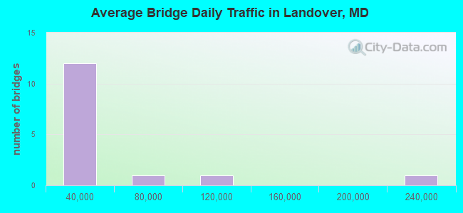
- 491,127Total average daily traffic
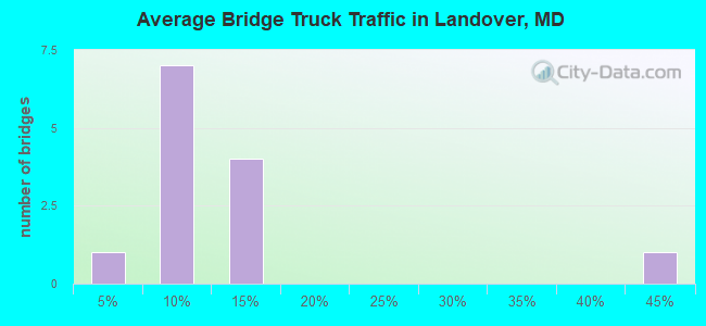
- 43,506Total average daily truck traffic
- National Bridge Inventory (NBI) Registered Bridges for Landover
- No street view available for this location
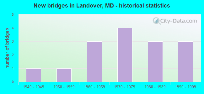
- New bridges - historical statistics
- 11940-1949
- 11950-1959
- 31960-1969
- 41970-1979
- 31980-1989
- 31990-1999
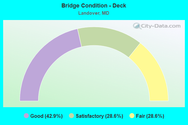
- Bridge Condition - Deck
- 42.9%Good
- 28.6%Satisfactory
- 28.6%Fair
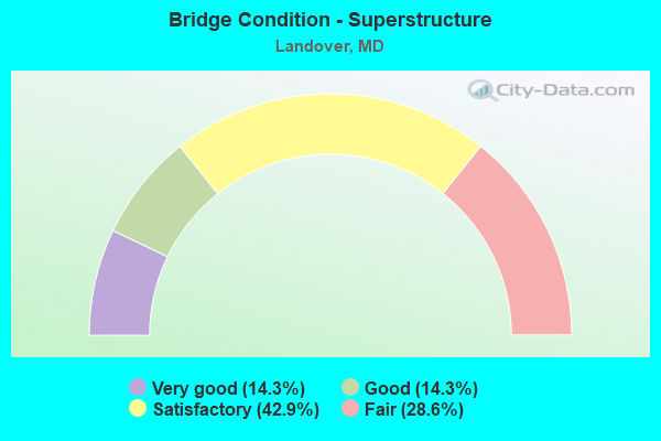
- Bridge Condition - Superstructure
- 14.3%Very good
- 14.3%Good
- 42.9%Satisfactory
- 28.6%Fair
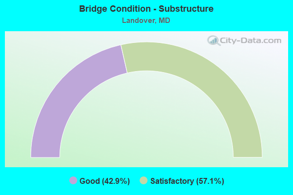
- Bridge Condition - Substructure
- 42.9%Good
- 57.1%Satisfactory
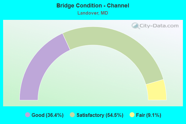
- Bridge Condition - Channel
- 36.4%Good
- 54.5%Satisfactory
- 9.1%Fair
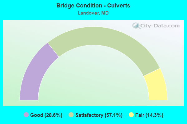
- Bridge Condition - Culverts
- 28.6%Good
- 57.1%Satisfactory
- 14.3%Fair
Find on map >> Show street view
Structure Number: 100000160029012, Location: 0.08 MILE SOUTH OF US 50 (Lat: 38.929944, Lng: -76.896639), Route carried "on" structure: State highway 202, Year Built: 1942, Year Reconstructed: 1993, Status: Open, Structure Length: 6.61m (21.69ft), Average Daily Traffic: 47,470 (year 2016), Truck Traffic: 8%, Average Future Daily Traffic: 52,406 (year 2038), Design Load: H 20, Features Intersected: AMTRAK, WMATA
Minimum Vertical Clearance: 30+ m (98+ ft), Kilometerpoint: 19.636, Lanes on structure: 2, Base Highway Network: Yes, Owner: State Highway Agency, Approaching Roadway Width: 9.1m (29.9ft), Material/Design: Steel, Design/Construction: Girder and Floorbeam System, Number Of Spans In Main Unit: 1, Number Of Approach Spans: 2, Length of Maximum Span: 38.1m (125.0ft), Curb or Sidewalk Widths: Left: 0.0m, Right: 1.3m (4.3ft), Curb-To-Curb Width: 9.1m (29.9ft), Out-to-Out Width: 11.0m (36.1ft)
Condition: Deck: Satisfactory, Superstructure: Satisfactory, Substructure: Satisfactory, Operating Rating: 79.4 metric tons, Method Used To Determine Operating Rating: Load Factor (LF), Inventory Rating: 47.6 metric tons, Method Used To Determine Inventory Rating: Load Factor (LF), Structural Evaluation: Equal to present minimum criteria, Deck Geometry: Meets minimum limits, Underclear: Equal to present desirable criteria, Approach Roadway Alignment: Equal to present desirable criteria, Length Of Structure Improvement: 6.61m (21.69ft), Designated Inspection Frequency: Every 24 months, Critical Feature Inspection Frequency: Every 24 months, Inspection Date: Febuary 2020, Critical Feature Inspection Date: Febuary 2020, Bridge Improvement Cost: $486,000, Roadway Improvement Cost: $49,000, Total Project Cost: $535,000, Deck Structure Type: Concrete Cast-file-Place, Wearing Surface/Protective System: Wearing Surface: Integral Concrete
Find on map >> Show street view
Structure Number: 10000016011401, Location: 0.74 MILE WEST OF IS 95 (Lat: 38.943953, Lng: -76.876978), Route carried "on" structure: US 50, Year Built: 1959, Year Reconstructed: 1988, Status: Open, Structure Length: 8.14m (26.71ft), Average Daily Traffic: 113,282 (year 2019), Truck Traffic: 8%, Average Future Daily Traffic: 168,330 (year 2039), Design Load: HS 20, Features Intersected: AMTRAK, WMATA
Minimum Vertical Clearance: 30+ m (98+ ft), Kilometerpoint: 6.927, Lanes on structure: 8, Base Highway Network: Yes, Owner: State Highway Agency, Approaching Roadway Width: 41.8m (137.1ft), Skew: 34 degrees, Material/Design: Steel, Design/Construction: Stringer/Multi-beam, Number Of Spans In Main Unit: 3, Length of Maximum Span: 33.5m (109.9ft), Curb-To-Curb Width: 41.9m (137.5ft), Out-to-Out Width: 42.8m (140.4ft)
Condition: Deck: Good, Superstructure: Satisfactory, Substructure: Satisfactory, Operating Rating: 63.0 metric tons, Method Used To Determine Operating Rating: Load Factor (LF), Inventory Rating: 37.6 metric tons, Method Used To Determine Inventory Rating: Load Factor (LF), Structural Evaluation: Equal to present minimum criteria, Deck Geometry: Superior to present desirable criteria, Underclear: High priority of corrective action, Approach Roadway Alignment: Equal to present desirable criteria, Designated Inspection Frequency: Every 24 months, Critical Feature Inspection Frequency: Every 24 months, Inspection Date: Febuary 2020, Critical Feature Inspection Date: Febuary 2020, Deck Structure Type: Concrete Cast-file-Place, Wearing Surface/Protective System: Wearing Surface: Monolithic Concrete, Deck Protection: Epoxy Coated Reinforcing
Find on map >> Show street view
Structure Number: 10000016017701, Location: .25 MI NW OF USAIR ARENA (Lat: 38.907075, Lng: -76.850250), Route carried "on" structure: ServiceState highway 202F, Year Built: 1997, Status: Open, Structure Length: 11.43m (37.50ft), Average Daily Traffic: 18,790 (year 2016), Truck Traffic: 4%, Average Future Daily Traffic: 56,840 (year 2036), Design Load: HS 25 or greater, Features Intersected: IS 95
Minimum Vertical Clearance: 30+ m (98+ ft), Kilometerpoint: 1.545, Lanes on structure: 4, Lanes under structure: 8, Owner: State Highway Agency, Approaching Roadway Width: 16.5m (54.1ft), Material/Design: Steel continuous, Design/Construction: Stringer/Multi-beam, Number Of Spans In Main Unit: 3, Length of Maximum Span: 41.1m (134.8ft), Curb-To-Curb Width: 16.3m (53.5ft), Out-to-Out Width: 20.1m (65.9ft)
Condition: Deck: Good, Superstructure: Good, Substructure: Good, Operating Rating: 70.7 metric tons, Method Used To Determine Operating Rating: Load Factor (LF), Inventory Rating: 42.2 metric tons, Method Used To Determine Inventory Rating: Load Factor (LF), Structural Evaluation: Better than present minimum criteria, Deck Geometry: Meets minimum limits, Underclear: Somewhat better than minimum adequacy, Approach Roadway Alignment: Equal to present desirable criteria, Designated Inspection Frequency: Every 24 months, Inspection Date: September 2020, Deck Structure Type: Concrete Cast-file-Place, Wearing Surface/Protective System: Wearing Surface: Integral Concrete, Deck Protection: Epoxy Coated Reinforcing
Find on map >> Show street view
Structure Number: 10000016026203, Location: 0.09 MILE WEST OF MD 202E (Lat: 38.914458, Lng: -76.862450), Route carried "on" structure: State highway 202D, Year Built: 1963, Status: Open, Structure Length: 0.70m (2.30ft), Average Daily Traffic: 12,770 (year 2009), Truck Traffic: 5%, Average Future Daily Traffic: 17,076 (year 2026), Features Intersected: TRIB TO CATTAIL CREEK
Minimum Vertical Clearance: 30+ m (98+ ft), Kilometerpoint: 0.145, Lanes on structure: 2, Owner: State Highway Agency, Approaching Roadway Width: 15.9m (52.2ft), Skew: 4 degrees, Material/Design: Steel, Design/Construction: Culvert, Length of Maximum Span: 2.1m (6.9ft)
Condition: Channel: Good, Culverts: Satisfactory, Structural Evaluation: Equal to present minimum criteria, Waterway Adequacy: Somewhat better than minimum adequacy, Approach Roadway Alignment: Equal to present desirable criteria, Length Of Structure Improvement: 0.70m (2.30ft), Designated Inspection Frequency: Every 24 months, Inspection Date: April 2020, Bridge Improvement Cost: $55,000, Roadway Improvement Cost: $6,000, Total Project Cost: $61,000
Find on map >> Show street view
Structure Number: 200000P-020102, Location: 0.57 MI W OF MD 704 (Lat: 38.907306, Lng: -76.901900), Route carried "on" structure: County highway 75, Year Built: 1974, Status: Open, Structure Length: 1.04m (3.41ft), Average Daily Traffic: 19,206 (year 2016), Truck Traffic: 40%, Average Future Daily Traffic: 28,540 (year 2036), Design Load: HS 20, Features Intersected: CABIN BRANCH, Facility Carried by Structure: SHERIFF ROAD
Minimum Vertical Clearance: 30+ m (98+ ft), Kilometerpoint: 3.797, Lanes on structure: 4, Owner: County Highway Agency, Approaching Roadway Width: 15.9m (52.2ft), Skew: 2 degrees, Material/Design: Concrete, Design/Construction: Culvert, Number Of Spans In Main Unit: 2, Length of Maximum Span: 6.7m (22.0ft)
Condition: Channel: Satisfactory, Culverts: Satisfactory, Structural Evaluation: Equal to present minimum criteria, Waterway Adequacy: Somewhat better than minimum adequacy, Approach Roadway Alignment: Equal to present desirable criteria, Length Of Structure Improvement: 1.59m (5.22ft), Designated Inspection Frequency: Every 24 months, Inspection Date: January 2021, Bridge Improvement Cost: $66,000, Roadway Improvement Cost: $7,000, Total Project Cost: $73,000
Find on map >> Show street view
Structure Number: 200000P-020702, Location: 0.2 MI NORTH OF MD 214 (Lat: 38.892125, Lng: -76.852089), Route carried "on" structure: County highway 76, Year Built: 1979, Status: Posted for load, Structure Length: 0.64m (2.10ft), Average Daily Traffic: 13,694 (year 2021), Truck Traffic: 5%, Average Future Daily Traffic: 16,879 (year 2041), Design Load: HS 20, Features Intersected: TRIB TO SOUTHWEST BRANCH, Facility Carried by Structure: BRIGHTSEAT ROAD
Minimum Vertical Clearance: 30+ m (98+ ft), Kilometerpoint: 0.000, Lanes on structure: 4, Owner: County Highway Agency, Approaching Roadway Width: 14.9m (48.9ft), Material/Design: Concrete, Design/Construction: Culvert, Number Of Spans In Main Unit: 2, Length of Maximum Span: 3.0m (9.8ft), Curb or Sidewalk Widths: Left: 1.2m (3.9ft), Right: 1.2m (3.9ft)
Condition: Channel: Satisfactory, Culverts: Satisfactory, Operating Rating: 65.3 metric tons, Method Used To Determine Operating Rating: Load Factor (LF), Inventory Rating: 39.0 metric tons, Method Used To Determine Inventory Rating: Load Factor (LF), Structural Evaluation: Equal to present minimum criteria, Waterway Adequacy: Better than present minimum criteria, Approach Roadway Alignment: Equal to present minimum criteria, Length Of Structure Improvement: 0.91m (2.99ft), Designated Inspection Frequency: Every 24 months, Inspection Date: March 2021, Bridge Improvement Cost: $500,000, Roadway Improvement Cost: $50,000, Total Project Cost: $550,000
Find on map >> Show street view
Structure Number: 200000P-026702, Location: 0.2 MI SOUTH OF MD 202 (Lat: 38.910611, Lng: -76.840492), Route carried "on" structure: County highway 64, Year Built: 1986, Status: Open, Structure Length: 1.01m (3.31ft), Average Daily Traffic: 19,215 (year 2019), Truck Traffic: 5%, Average Future Daily Traffic: 28,560 (year 2039), Design Load: HS 20, Features Intersected: UNNAMED STREAM, Facility Carried by Structure: LOTTSFORD ROAD
Minimum Vertical Clearance: 30+ m (98+ ft), Kilometerpoint: 0.000, Lanes on structure: 7, Owner: County Highway Agency, Approaching Roadway Width: 29.3m (96.1ft), Skew: 3 degrees, Material/Design: Concrete, Design/Construction: Culvert, Length of Maximum Span: 2.7m (8.9ft), Curb or Sidewalk Widths: Left: 1.2m (3.9ft), Right: 1.2m (3.9ft)
Condition: Channel: Good, Culverts: Satisfactory, Operating Rating: 32.7 metric tons, Method Used To Determine Operating Rating: Field evaluation and documented engineering judgment, Inventory Rating: 32.7 metric tons, Method Used To Determine Inventory Rating: Field evaluation and documented engineering judgment, Structural Evaluation: Equal to present minimum criteria, Waterway Adequacy: Equal to present desirable criteria, Approach Roadway Alignment: Equal to present desirable criteria, Designated Inspection Frequency: Every 24 months, Inspection Date: April 2020
Find on map >> Show street view
Structure Number: 200000P-026802, Location: 0.5 MI SOUTH OF MD 202 (Lat: 38.909572, Lng: -76.846206), Route carried "on" structure: County highway 4565, Year Built: 1982, Status: Open, Structure Length: 0.82m (2.69ft), Average Daily Traffic: 9,830 (year 2017), Truck Traffic: 5%, Average Future Daily Traffic: 14,640 (year 2037), Design Load: HS 20, Features Intersected: UNNAMED STREAM, Facility Carried by Structure: McCORMICK DRIVE
Minimum Vertical Clearance: 30+ m (98+ ft), Kilometerpoint: 0.805, Lanes on structure: 4, Owner: County Highway Agency, Approaching Roadway Width: 14.0m (45.9ft), Material/Design: Concrete, Design/Construction: Culvert, Number Of Spans In Main Unit: 4, Length of Maximum Span: 1.8m (5.9ft), Curb or Sidewalk Widths: Left: 1.2m (3.9ft), Right: 1.2m (3.9ft)
Condition: Channel: Satisfactory, Culverts: Good, Operating Rating: 54.4 metric tons, Method Used To Determine Operating Rating: Load Factor (LF), Inventory Rating: 32.7 metric tons, Method Used To Determine Inventory Rating: Load Factor (LF), Structural Evaluation: Better than present minimum criteria, Waterway Adequacy: Somewhat better than minimum adequacy, Approach Roadway Alignment: Equal to present desirable criteria, Designated Inspection Frequency: Every 24 months, Inspection Date: March 2021
Find on map >> Show street view
Structure Number: 200000P-028301, Location: 1 MI E OF MD 202 (Lat: 38.919325, Lng: -76.817192), Route carried "on" structure: County highway 64, Year Built: 1989, Status: Open, Structure Length: 4.24m (13.91ft), Average Daily Traffic: 18,846 (year 2021), Truck Traffic: 10%, Average Future Daily Traffic: 29,807 (year 2041), Design Load: HS 20, Features Intersected: WESTERN BRANCH, Facility Carried by Structure: LOTTSFORD ROAD
Minimum Vertical Clearance: 30+ m (98+ ft), Kilometerpoint: 2.156, Lanes on structure: 2, Owner: County Highway Agency, Approaching Roadway Width: 13.4m (44.0ft), Material/Design: Steel continuous, Design/Construction: Stringer/Multi-beam, Number Of Spans In Main Unit: 3, Length of Maximum Span: 16.2m (53.1ft), Curb-To-Curb Width: 13.4m (44.0ft), Out-to-Out Width: 14.4m (47.2ft)
Condition: Deck: Good, Superstructure: Satisfactory, Substructure: Good, Channel: Good, Operating Rating: 64.9 metric tons, Method Used To Determine Operating Rating: Load Factor (LF), Inventory Rating: 39.0 metric tons, Method Used To Determine Inventory Rating: Load Factor (LF), Structural Evaluation: Equal to present minimum criteria, Deck Geometry: Equal to present minimum criteria, Waterway Adequacy: Equal to present desirable criteria, Approach Roadway Alignment: Equal to present desirable criteria, Designated Inspection Frequency: Every 24 months, Inspection Date: March 2021, Deck Structure Type: Concrete Cast-file-Place, Wearing Surface/Protective System: Wearing Surface: Monolithic Concrete, Deck Protection: Epoxy Coated Reinforcing
Find on map >> Show street view
Structure Number: 200000P-028401, Location: 2.23 MI SOUTH OF MD 704 (Lat: 38.925378, Lng: -76.819658), Route carried "on" structure: County highway 67, Year Built: 1999, Status: Open, Structure Length: 2.35m (7.71ft), Average Daily Traffic: 7,518 (year 2021), Truck Traffic: 10%, Average Future Daily Traffic: 11,201 (year 2041), Design Load: HS 20, Features Intersected: LOTTSFORD BRANCH, Facility Carried by Structure: LOTTSFORD VISTA RD
Minimum Vertical Clearance: 30+ m (98+ ft), Kilometerpoint: 3.588, Lanes on structure: 2, Owner: County Highway Agency, Approaching Roadway Width: 11.0m (36.1ft), Skew: 3 degrees, Material/Design: Prestressed concrete, Design/Construction: Stringer/Multi-beam, Number Of Spans In Main Unit: 1, Length of Maximum Span: 22.3m (73.2ft), Curb-To-Curb Width: 10.7m (35.1ft), Out-to-Out Width: 12.4m (40.7ft)
Condition: Deck: Satisfactory, Superstructure: Very good, Substructure: Good, Channel: Good, Operating Rating: 59.9 metric tons, Method Used To Determine Operating Rating: Load Factor (LF), Inventory Rating: 35.8 metric tons, Method Used To Determine Inventory Rating: Load Factor (LF), Structural Evaluation: Better than present minimum criteria, Deck Geometry: Meets minimum limits, Waterway Adequacy: Equal to present desirable criteria, Approach Roadway Alignment: Equal to present minimum criteria, Designated Inspection Frequency: Every 24 months, Inspection Date: March 2021, Deck Structure Type: Concrete Cast-file-Place, Wearing Surface/Protective System: Wearing Surface: Monolithic Concrete, Deck Protection: Epoxy Coated Reinforcing
Find on map >> Show street view
Structure Number: 200000P-028502, Location: 0.35 MI S OF MD 202 (Lat: 38.921775, Lng: -76.885742), Route carried "on" structure: County highway 3361, Year Built: 1968, Status: Posted for load, Structure Length: 1.31m (4.30ft), Average Daily Traffic: 4,190 (year 2019), Truck Traffic: 10%, Average Future Daily Traffic: 6,230 (year 2039), Features Intersected: CATTAIL BRANCH, Facility Carried by Structure: KENT VILLAGE DRIVE
Minimum Vertical Clearance: 30+ m (98+ ft), Kilometerpoint: 0.563, Lanes on structure: 2, Owner: County Highway Agency, Approaching Roadway Width: 11.0m (36.1ft), Material/Design: Concrete, Design/Construction: Culvert, Length of Maximum Span: 2.4m (7.9ft), Curb or Sidewalk Widths: Left: 1.5m (4.9ft), Right: 1.2m (3.9ft)
Condition: Channel: Fair, Culverts: Fair, Operating Rating: 39.0 metric tons, Method Used To Determine Operating Rating: Load Factor (LF), Inventory Rating: 22.7 metric tons, Method Used To Determine Inventory Rating: Load Factor (LF), Structural Evaluation: Somewhat better than minimum adequacy, Waterway Adequacy: Equal to present minimum criteria, Approach Roadway Alignment: Equal to present desirable criteria, Designated Inspection Frequency: Every 24 months, Inspection Date: January 2021
Find on map >> Show street view
Structure Number: 200000P-028702, Location: 0.10 M W OF KENTTOWN PL (Lat: 38.924967, Lng: -76.888831), Route carried "on" structure: County highway 691, Year Built: 1969, Status: Posted for load, Structure Length: 1.74m (5.71ft), Average Daily Traffic: 950 (year 2019), Truck Traffic: 10%, Average Future Daily Traffic: 1,420 (year 2039), Features Intersected: CATTAIL BRANCH, Facility Carried by Structure: HAWTHORNE STREET
Minimum Vertical Clearance: 30+ m (98+ ft), Kilometerpoint: 0.853, Lanes on structure: 2, Owner: County Highway Agency, Approaching Roadway Width: 11.0m (36.1ft), Skew: 3 degrees, Material/Design: Concrete, Design/Construction: Culvert, Length of Maximum Span: 4.0m (13.1ft), Curb or Sidewalk Widths: Left: 1.2m (3.9ft), Right: 1.5m (4.9ft)
Condition: Channel: Satisfactory, Culverts: Good, Operating Rating: 32.7 metric tons, Method Used To Determine Operating Rating: Load Factor (LF), Inventory Rating: 19.5 metric tons, Method Used To Determine Inventory Rating: Load Factor (LF), Structural Evaluation: Somewhat better than minimum adequacy, Waterway Adequacy: Better than present minimum criteria, Approach Roadway Alignment: Equal to present desirable criteria, Bridge Posting: Required (Relationship of Operating Rating to Maximum Legal Load: 10.0 - 19.9% below), Length Of Structure Improvement: 2.23m (7.32ft), Designated Inspection Frequency: Every 12 months, Inspection Date: January 2021
Find on map >> Show street view
Structure Number: 300000P-WM1001, Location: 0.5 MI N MD 202 (Lat: 38.932128, Lng: -76.889128), Route carried "on" structure: Ramp Other road , Year Built: 1979, Status: Open, Structure Length: 4.55m (14.93ft), Average Daily Traffic: 853 (year 2017), Average Future Daily Traffic: 1,040 (year 2037), Design Load: HS 20, Features Intersected: BEAVERDAM CREEK, Facility Carried by Structure: S LANDOVER ACCESS
Minimum Vertical Clearance: 30+ m (98+ ft), Kilometerpoint: 0.000, Lanes on structure: 2, Owner: Railroad, Approaching Roadway Width: 11.0m (36.1ft), Material/Design: Concrete, Design/Construction: Slab, Number Of Spans In Main Unit: 3, Length of Maximum Span: 18.3m (60.0ft), Curb or Sidewalk Widths: Left: 1.5m (4.9ft), Right: 0.0m, Curb-To-Curb Width: 11.0m (36.1ft), Out-to-Out Width: 13.4m (44.0ft)
Condition: Deck: Fair, Superstructure: Fair, Substructure: Satisfactory, Channel: Satisfactory, Operating Rating: 59.9 metric tons, Method Used To Determine Operating Rating: Load Factor (LF), Inventory Rating: 36.3 metric tons, Method Used To Determine Inventory Rating: Load Factor (LF), Structural Evaluation: Somewhat better than minimum adequacy, Deck Geometry: Better than present minimum criteria, Waterway Adequacy: Equal to present desirable criteria, Approach Roadway Alignment: Equal to present minimum criteria, Designated Inspection Frequency: Every 24 months, Inspection Date: July 2020, Deck Structure Type: Concrete Cast-file-Place, Wearing Surface/Protective System: Wearing Surface: Monolithic Concrete
Find on map >> Show street view
Structure Number: 300000P-WM1101, Location: 0.5 MI N MD 202 (Lat: 38.930839, Lng: -76.891411), Route carried "on" structure: Ramp Other road , Year Built: 1979, Status: Open, Structure Length: 4.55m (14.93ft), Average Daily Traffic: 853 (year 2017), Average Future Daily Traffic: 1,040 (year 2037), Design Load: HS 20, Features Intersected: BEAVERDAM CREEK, Facility Carried by Structure: N LANDOVER ACCESS
Minimum Vertical Clearance: 30+ m (98+ ft), Kilometerpoint: 0.000, Lanes on structure: 2, Owner: Railroad, Approaching Roadway Width: 11.0m (36.1ft), Material/Design: Concrete, Design/Construction: Slab, Number Of Spans In Main Unit: 3, Length of Maximum Span: 18.3m (60.0ft), Curb or Sidewalk Widths: Left: 1.5m (4.9ft), Right: 0.0m, Curb-To-Curb Width: 11.0m (36.1ft), Out-to-Out Width: 13.4m (44.0ft)
Condition: Deck: Fair, Superstructure: Fair, Substructure: Satisfactory, Channel: Satisfactory, Operating Rating: 59.9 metric tons, Method Used To Determine Operating Rating: Load Factor (LF), Inventory Rating: 36.3 metric tons, Method Used To Determine Inventory Rating: Load Factor (LF), Structural Evaluation: Somewhat better than minimum adequacy, Deck Geometry: Better than present minimum criteria, Waterway Adequacy: Better than present minimum criteria, Approach Roadway Alignment: Equal to present minimum criteria, Designated Inspection Frequency: Every 24 months, Inspection Date: July 2020, Deck Structure Type: Concrete Cast-file-Place, Wearing Surface/Protective System: Wearing Surface: Monolithic Concrete
Find on map >> Show street view
Structure Number: 10000016017701, Location: 1.05 M N OF BR NO 1615300 (Lat: 38.907075, Lng: -76.850250), Route carried "under" structure: Interstate 95, Year Built: 1997, Structure Length: 0. m, Average Daily Traffic: 203,660 (year 2009), Truck Traffic: 8%, Features Intersected: IS 95, Facility Carried by Structure: MD 202F (ARENA DR)
Minimum Vertical Clearance: 4.88m (16.01ft), Kilometerpoint: 25.470, Lanes on structure: 4, Lanes under structure: 8, Material/Design: Steel continuous, Design/Construction: Stringer/Multi-beam, Length of Maximum Span: 41.1m (134.8ft)