Bridge Statistics for Lava Hot Springs, Idaho (ID)
Condition, Traffic, Stress, Structural Evaluation, Project Costs
- National Bridge Inventory (NBI) Statistics
- 10Number of bridges
- 92ft / 28.4mTotal length
- $7,639,000Total costs
- 20,645Total average daily traffic
- 4,339Total average daily truck traffic
- 30,968Total future (year 2039) average daily traffic
- National Bridge Inventory (NBI) Registered Bridges for Lava Hot Springs
- No street view available for this location
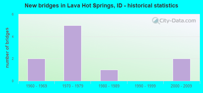
- New bridges - historical statistics
- 21960-1969
- 51970-1979
- 11980-1989
- 22000-2009


- Bridge Condition - Deck
- 80.0%Good
- 10.0%Satisfactory
- 10.0%Fair

- Bridge Condition - Superstructure
- 10.0%Very good
- 40.0%Good
- 30.0%Satisfactory
- 20.0%Fair

- Bridge Condition - Substructure
- 20.0%Very good
- 30.0%Good
- 40.0%Satisfactory
- 10.0%Fair

- Bridge Condition - Channel
- 75.0%Very good
- 25.0%Good
Find on map >> Show street view
Structure Number: 13711, Location: 1.9 W. LAVA HOT SPRINGS (Lat: 42.619611, Lng: -112.046278), Route carried "on" structure: US 30, Year Built: 2008, Status: Open, Structure Length: 5.52m (18.11ft), Average Daily Traffic: 5,500 (year 2019), Truck Traffic: 20%, Average Future Daily Traffic: 8,250 (year 2039), Design Load: HL 93, Features Intersected: PORTNEUF RIVER
Minimum Vertical Clearance: 30+ m (98+ ft), Kilometerpoint: 593.922, Lanes on structure: 4, Base Highway Network: Yes (Inventory Route: US0, Subroute: 1), Owner: State Highway Agency, Approaching Roadway Width: 22.9m (75.1ft), Material/Design: Prestressed concrete, Design/Construction: Stringer/Multi-beam, Number Of Spans In Main Unit: 2, Length of Maximum Span: 32.0m (105.0ft), Curb-To-Curb Width: 24.1m (79.1ft), Out-to-Out Width: 25.0m (82.0ft)
Condition: Deck: Good, Superstructure: Very good, Substructure: Very good, Channel: Very good, Operating Rating: 78.0 metric tons, Method Used To Determine Operating Rating: Load Factor (LF), Inventory Rating: 46.3 metric tons, Method Used To Determine Inventory Rating: Load Factor (LF), Structural Evaluation: Equal to present desirable criteria, Deck Geometry: Superior to present desirable criteria, Waterway Adequacy: Equal to present desirable criteria, Approach Roadway Alignment: Equal to present desirable criteria, Designated Inspection Frequency: Every 48 months, Inspection Date: July 2018, Deck Structure Type: Concrete Cast-file-Place, Wearing Surface/Protective System: Wearing Surface: Monolithic Concrete, Deck Protection: Epoxy Coated Reinforcing
Find on map >> Show street view
Structure Number: 13715, Location: AT LAVA HOT SPRINGS ECL (Lat: 42.622917, Lng: -111.996333), Route carried "on" structure: US 30, Year Built: 1977, Status: Open, Structure Length: 7.77m (25.49ft), Average Daily Traffic: 3,900 (year 2019), Truck Traffic: 26%, Average Future Daily Traffic: 5,850 (year 2039), Design Load: HS 20, Features Intersected: PORTNEUF RIVER
Minimum Vertical Clearance: 30+ m (98+ ft), Kilometerpoint: 598.324, Lanes on structure: 3, Base Highway Network: Yes (Inventory Route: US0, Subroute: 1), Owner: State Highway Agency, Approaching Roadway Width: 15.2m (49.9ft), Skew: 2 degrees, Material/Design: Prestressed concrete, Design/Construction: Stringer/Multi-beam, Number Of Spans In Main Unit: 3, Length of Maximum Span: 37.2m (122.0ft), Curb-To-Curb Width: 15.4m (50.5ft), Out-to-Out Width: 16.3m (53.5ft)
Condition: Deck: Fair, Superstructure: Fair, Substructure: Satisfactory, Channel: Very good, Operating Rating: 44.5 metric tons, Method Used To Determine Operating Rating: Load Factor (LF), Inventory Rating: 26.3 metric tons, Method Used To Determine Inventory Rating: Load Factor (LF), Structural Evaluation: Somewhat better than minimum adequacy, Deck Geometry: Equal to present minimum criteria, Waterway Adequacy: Superior to present desirable criteria, Approach Roadway Alignment: Equal to present desirable criteria, Length Of Structure Improvement: 10.06m (33.01ft), Designated Inspection Frequency: Every 24 months, Inspection Date: October 2021, Bridge Improvement Cost: $2,940,000, Roadway Improvement Cost: $294,000, Total Project Cost: $4,410,000 ( Estimate for 2017), Deck Structure Type: Concrete Cast-file-Place, Wearing Surface/Protective System: Wearing Surface: Latex Concrete
Find on map >> Show street view
Structure Number: 1372, Location: 1.8 E. LAVA HOT SPRINGS (Lat: 42.619111, Lng: -111.985528), Route carried "on" structure: US 30, Year Built: 1977, Status: Open, Structure Length: 2.32m (7.61ft), Average Daily Traffic: 3,900 (year 2019), Truck Traffic: 26%, Average Future Daily Traffic: 5,850 (year 2039), Design Load: HS 20, Features Intersected: DEER CROSSING
Minimum Vertical Clearance: 30+ m (98+ ft), Kilometerpoint: 599.373, Lanes on structure: 3, Base Highway Network: Yes (Inventory Route: US0, Subroute: 1), Owner: State Highway Agency, Approaching Roadway Width: 15.2m (49.9ft), Material/Design: Prestressed concrete, Design/Construction: Stringer/Multi-beam, Number Of Spans In Main Unit: 1, Length of Maximum Span: 22.9m (75.1ft), Curb-To-Curb Width: 15.4m (50.5ft), Out-to-Out Width: 16.5m (54.1ft)
Condition: Deck: Good, Superstructure: Satisfactory, Substructure: Satisfactory, Operating Rating: 61.7 metric tons, Method Used To Determine Operating Rating: Load Factor (LF), Inventory Rating: 27.2 metric tons, Method Used To Determine Inventory Rating: Load Factor (LF), Structural Evaluation: Equal to present minimum criteria, Deck Geometry: Equal to present minimum criteria, Approach Roadway Alignment: Equal to present desirable criteria, Length Of Structure Improvement: 3.02m (9.91ft), Designated Inspection Frequency: Every 24 months, Inspection Date: October 2021, Bridge Improvement Cost: $882,000, Roadway Improvement Cost: $88,000, Total Project Cost: $1,323,000 ( Estimate for 2019), Deck Structure Type: Concrete Cast-file-Place, Wearing Surface/Protective System: Wearing Surface: Latex Concrete
Find on map >> Show street view
Structure Number: 13725, Location: 2.5 E. LAVA HOT SPRINGS (Lat: 42.617583, Lng: -111.972861), Route carried "on" structure: US 30, Year Built: 1977, Status: Open, Structure Length: 2.32m (7.61ft), Average Daily Traffic: 3,900 (year 2019), Truck Traffic: 26%, Average Future Daily Traffic: 5,850 (year 2039), Design Load: HS 20, Features Intersected: DEER CROSSING
Minimum Vertical Clearance: 30+ m (98+ ft), Kilometerpoint: 600.482, Lanes on structure: 3, Base Highway Network: Yes (Inventory Route: US0, Subroute: 1), Owner: State Highway Agency, Approaching Roadway Width: 15.2m (49.9ft), Material/Design: Prestressed concrete, Design/Construction: Stringer/Multi-beam, Number Of Spans In Main Unit: 1, Length of Maximum Span: 22.9m (75.1ft), Curb-To-Curb Width: 15.4m (50.5ft), Out-to-Out Width: 16.4m (53.8ft)
Condition: Deck: Good, Superstructure: Satisfactory, Substructure: Satisfactory, Operating Rating: 61.7 metric tons, Method Used To Determine Operating Rating: Load Factor (LF), Inventory Rating: 27.2 metric tons, Method Used To Determine Inventory Rating: Load Factor (LF), Structural Evaluation: Equal to present minimum criteria, Deck Geometry: Equal to present minimum criteria, Waterway Adequacy: Equal to present desirable criteria, Approach Roadway Alignment: Equal to present desirable criteria, Length Of Structure Improvement: 3.02m (9.91ft), Designated Inspection Frequency: Every 24 months, Inspection Date: October 2020, Bridge Improvement Cost: $719,000, Roadway Improvement Cost: $72,000, Total Project Cost: $1,079,000 ( Estimate for 2018), Deck Structure Type: Concrete Cast-file-Place, Wearing Surface/Protective System: Wearing Surface: Latex Concrete
Find on map >> Show street view
Structure Number: 138, Location: IN LAVA HOT SPRINGS (Lat: 42.620222, Lng: -112.012083), Route carried "on" structure: Spur US 30, Year Built: 1962, Year Reconstructed: 2008, Status: Open, Structure Length: 1.34m (4.40ft), Average Daily Traffic: 1,300 (year 2019), Truck Traffic: 6%, Average Future Daily Traffic: 1,950 (year 2039), Design Load: HL 93, Features Intersected: PORTNEUF RIVER;IN LAVA
Minimum Vertical Clearance: 30+ m (98+ ft), Kilometerpoint: 0.367, Lanes on structure: 2, Owner: State Highway Agency, Approaching Roadway Width: 9.1m (29.9ft), Material/Design: Prestressed concrete, Design/Construction: Stringer/Multi-beam, Number Of Spans In Main Unit: 1, Length of Maximum Span: 12.8m (42.0ft), Curb-To-Curb Width: 9.1m (29.9ft), Out-to-Out Width: 10.0m (32.8ft)
Condition: Deck: Good, Superstructure: Good, Substructure: Satisfactory, Channel: Very good, Operating Rating: 73.5 metric tons, Method Used To Determine Operating Rating: Load Factor (LF), Inventory Rating: 44.5 metric tons, Method Used To Determine Inventory Rating: Load Factor (LF), Structural Evaluation: Equal to present minimum criteria, Deck Geometry: Somewhat better than minimum adequacy, Waterway Adequacy: Superior to present desirable criteria, Approach Roadway Alignment: Equal to present desirable criteria, Designated Inspection Frequency: Every 48 months, Inspection Date: October 2021, Deck Structure Type: Concrete Precast Panels, Wearing Surface/Protective System: Wearing Surface: Bituminous, Deck Protection: Epoxy Coated Reinforcing
Find on map >> Show street view
Structure Number: 21925, Location: 3.9N. 0.6W.LAVA HOT SPRGS (Lat: 42.674500, Lng: -112.019667), Route carried "on" structure: County highway , Year Built: 1986, Status: Open, Structure Length: 1.92m (6.30ft), Average Daily Traffic: 30 (year 2019), Truck Traffic: 33%, Average Future Daily Traffic: 45 (year 2039), Design Load: HS 20, Features Intersected: PORTNEUF RIVER, Facility Carried by Structure: SYMONS ROAD
Minimum Vertical Clearance: 30+ m (98+ ft), Kilometerpoint: 161.921, Lanes on structure: 2, Owner: County Highway Agency, Approaching Roadway Width: 9.4m (30.8ft), Material/Design: Prestressed concrete, Design/Construction: Box Beam or Girders - Multiple, Number Of Spans In Main Unit: 1, Length of Maximum Span: 18.3m (60.0ft), Curb-To-Curb Width: 10.1m (33.1ft), Out-to-Out Width: 11.0m (36.1ft)
Condition: Deck: Good, Superstructure: Good, Substructure: Good, Channel: Very good, Operating Rating: 59.9 metric tons, Method Used To Determine Operating Rating: Load Factor (LF), Inventory Rating: 19.1 metric tons, Method Used To Determine Inventory Rating: Load Factor (LF), Structural Evaluation: Somewhat better than minimum adequacy, Deck Geometry: Superior to present desirable criteria, Waterway Adequacy: Equal to present desirable criteria, Approach Roadway Alignment: Equal to present desirable criteria, Designated Inspection Frequency: Every 24 months, Inspection Date: April 2020, Deck Structure Type: Concrete Precast Panels, Wearing Surface/Protective System: Wearing Surface: Bituminous
Find on map >> Show street view
Structure Number: 21975, Location: IN LAVA HOT SPRINGS (Lat: 42.619278, Lng: -112.006278), Route carried "on" structure: City street 1757, Year Built: 1962, Status: Open, Structure Length: 1.31m (4.30ft), Average Daily Traffic: 1,300 (year 2019), Truck Traffic: 4%, Average Future Daily Traffic: 1,950 (year 2039), Design Load: HS 20, Features Intersected: PORTNEUF RIVER
Minimum Vertical Clearance: 30+ m (98+ ft), Kilometerpoint: 165.676, Lanes on structure: 2, Owner: City or Municipal Highway Agency, Approaching Roadway Width: 7.9m (25.9ft), Material/Design: Concrete, Design/Construction: Stringer/Multi-beam, Number Of Spans In Main Unit: 1, Length of Maximum Span: 12.8m (42.0ft), Curb or Sidewalk Widths: Left: 1.2m (3.9ft), Right: 0.4m (1.3ft), Curb-To-Curb Width: 7.8m (25.6ft), Out-to-Out Width: 10.0m (32.8ft)
Condition: Deck: Satisfactory, Superstructure: Satisfactory, Substructure: Fair, Channel: Good, Operating Rating: 35.4 metric tons, Method Used To Determine Operating Rating: Allowable Stress (AS), Inventory Rating: 25.4 metric tons, Method Used To Determine Inventory Rating: Allowable Stress (AS), Structural Evaluation: Somewhat better than minimum adequacy, Deck Geometry: Meets minimum limits, Waterway Adequacy: Equal to present desirable criteria, Approach Roadway Alignment: Equal to present desirable criteria, Length Of Structure Improvement: 1.46m (4.79ft), Designated Inspection Frequency: Every 24 months, Inspection Date: September 2021, Bridge Improvement Cost: $320,000, Roadway Improvement Cost: $32,000, Total Project Cost: $480,000, Deck Structure Type: Concrete Cast-file-Place, Wearing Surface/Protective System: Wearing Surface: Monolithic Concrete
Find on map >> Show street view
Structure Number: 22206, Location: 1.4 E. LAVA HOT SPRINGS (Lat: 42.631528, Lng: -112.000000), Route carried "on" structure: County highway 1759, Year Built: 2009, Status: Open, Structure Length: 2.56m (8.40ft), Average Daily Traffic: 730 (year 2019), Truck Traffic: 7%, Average Future Daily Traffic: 1,095 (year 2039), Design Load: HL 93, Features Intersected: PORTNEUF RIVER
Minimum Vertical Clearance: 30+ m (98+ ft), Kilometerpoint: 598.926, Lanes on structure: 2, Owner: County Highway Agency, Approaching Roadway Width: 9.8m (32.2ft), Material/Design: Concrete, Design/Construction: Tee Beam, Number Of Spans In Main Unit: 1, Length of Maximum Span: 24.4m (80.1ft), Curb-To-Curb Width: 9.5m (31.2ft), Out-to-Out Width: 10.4m (34.1ft)
Condition: Deck: Good, Superstructure: Good, Substructure: Very good, Channel: Very good, Operating Rating: 43.7 metric tons, Method Used To Determine Operating Rating: Load and Resistance Factor Rating (LRFR) rating reported by rating factor(RF) method using HL-93 loadings, Inventory Rating: 31.8 metric tons, Method Used To Determine Inventory Rating: Load and Resistance Factor Rating (LRFR) rating reported by rating factor(RF) method using HL-93 loadings, Structural Evaluation: Better than present minimum criteria, Deck Geometry: Equal to present minimum criteria, Waterway Adequacy: Better than present minimum criteria, Approach Roadway Alignment: Better than present minimum criteria, Designated Inspection Frequency: Every 48 months, Inspection Date: October 2021, Deck Structure Type: Concrete Precast Panels, Wearing Surface/Protective System: Wearing Surface: Bituminous, Deck Protection: Epoxy Coated Reinforcing
Find on map >> Show street view
Structure Number: 3279, Location: 4.6 N. 3.6 E. REXBURG (Lat: 43.893222, Lng: -111.717917), Route carried "on" structure: County highway , Year Built: 1976, Status: Open, Structure Length: 2.38m (7.81ft), Average Daily Traffic: 70 (year 2019), Truck Traffic: 10%, Average Future Daily Traffic: 105 (year 2039), Design Load: HS 20, Features Intersected: N.FK.TETON RIVER, Facility Carried by Structure: N 3000 E
Minimum Vertical Clearance: 30+ m (98+ ft), Kilometerpoint: 161.992, Lanes on structure: 2, Owner: County Highway Agency, Approaching Roadway Width: 8.5m (27.9ft), Material/Design: Prestressed concrete, Design/Construction: Stringer/Multi-beam, Number Of Spans In Main Unit: 1, Length of Maximum Span: 23.2m (76.1ft), Curb-To-Curb Width: 8.7m (28.5ft), Out-to-Out Width: 9.7m (31.8ft)
Condition: Deck: Good, Superstructure: Good, Substructure: Good, Channel: Very good, Operating Rating: 47.2 metric tons, Method Used To Determine Operating Rating: Field evaluation and documented engineering judgment, Inventory Rating: 28.1 metric tons, Method Used To Determine Inventory Rating: Field evaluation and documented engineering judgment, Structural Evaluation: Better than present minimum criteria, Deck Geometry: Better than present minimum criteria, Waterway Adequacy: Equal to present desirable criteria, Approach Roadway Alignment: Equal to present desirable criteria, Designated Inspection Frequency: Every 24 months, Inspection Date: October 2020, Deck Structure Type: Concrete Cast-file-Place, Wearing Surface/Protective System: Wearing Surface: Bituminous
Find on map >> Show street view
Structure Number: 346, Location: 22.0 NW SALMON (Lat: 45.426194, Lng: -114.167528), Route carried "on" structure: County highway , Year Built: 1970, Year Reconstructed: 2006, Status: Open, Structure Length: 0.91m (2.99ft), Average Daily Traffic: 15 (year 2019), Average Future Daily Traffic: 23 (year 2039), Design Load: HS 20, Features Intersected: INDIAN CREEK(#2), Facility Carried by Structure: INDIAN CREEK RD
Minimum Vertical Clearance: 30+ m (98+ ft), Kilometerpoint: 163.969, Lanes on structure: 1, Owner: County Highway Agency, Approaching Roadway Width: 4.0m (13.1ft), Skew: 1 degrees, Material/Design: Wood or Timber, Design/Construction: Stringer/Multi-beam, Number Of Spans In Main Unit: 1, Length of Maximum Span: 8.5m (27.9ft), Curb or Sidewalk Widths: Left: 0.2m (0.7ft), Right: 0.2m (0.7ft), Curb-To-Curb Width: 4.4m (14.4ft), Out-to-Out Width: 4.9m (16.1ft)
Condition: Deck: Good, Superstructure: Fair, Substructure: Good, Channel: Good, Operating Rating: 41.7 metric tons, Method Used To Determine Operating Rating: Load Factor (LF), Inventory Rating: 29.0 metric tons, Method Used To Determine Inventory Rating: Load Factor (LF), Structural Evaluation: Somewhat better than minimum adequacy, Deck Geometry: Equal to present minimum criteria, Waterway Adequacy: Somewhat better than minimum adequacy, Approach Roadway Alignment: Somewhat better than minimum adequacy, Length Of Structure Improvement: 1.52m (4.99ft), Designated Inspection Frequency: Every 24 months, Inspection Date: July 2020, Bridge Improvement Cost: $231,000, Roadway Improvement Cost: $23,000, Total Project Cost: $347,000 ( Estimate for 2015), Deck Structure Type: Wood or Timber, Wearing Surface/Protective System: Wearing Surface: Gravel