Bridge Statistics for Lawrence, Michigan (MI)
Condition, Traffic, Stress, Structural Evaluation, Project Costs
- National Bridge Inventory (NBI) Statistics
- 21Number of bridges
- 180ft / 55.4mTotal length
- 217,592Total average daily traffic
- 49,164Total average daily truck traffic
- National Bridge Inventory (NBI) Registered Bridges for Lawrence
- No street view available for this location
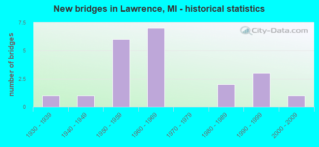
- New bridges - historical statistics
- 11930-1939
- 11940-1949
- 61950-1959
- 71960-1969
- 21980-1989
- 31990-1999
- 12000-2009


- Bridge Condition - Deck
- 7.1%Very good
- 42.9%Good
- 50.0%Satisfactory

- Bridge Condition - Superstructure
- 28.6%Very good
- 21.4%Good
- 50.0%Satisfactory

- Bridge Condition - Substructure
- 14.3%Very good
- 57.1%Good
- 28.6%Satisfactory

- Bridge Condition - Channel
- 54.5%Good
- 18.2%Satisfactory
- 27.3%Fair

- Bridge Condition - Culverts
- 50.0%Good
- 50.0%Satisfactory
Find on map >> Show street view
Structure Number: 108, Location: 3.0 MI N OF VAN BUREN COL (Lat: 42.456072, Lng: -86.235361), Route carried "on" structure: Interstate 196, Year Built: 1963, Status: Open, Structure Length: 3.86m (12.66ft), Average Daily Traffic: 10,500 (year 2010), Truck Traffic: 23%, Average Future Daily Traffic: 12,850 (year 2030), Design Load: HS 20+Mod, Features Intersected: 71 ST STREET
Minimum Vertical Clearance: 30.48m (100.00ft), Kilometerpoint: 4.400, Lanes on structure: 2, Lanes under structure: 2, Base Highway Network: Yes (Inventory Route: 78, Subroute: 8), Owner: State Highway Agency, Approaching Roadway Width: 12.2m (40.0ft), Skew: 3 degrees, Material/Design: Prestressed concrete, Design/Construction: Stringer/Multi-beam, Number Of Spans In Main Unit: 3, Length of Maximum Span: 14.5m (47.6ft), Curb-To-Curb Width: 12.0m (39.4ft), Out-to-Out Width: 13.1m (43.0ft)
Condition: Deck: Satisfactory, Superstructure: Satisfactory, Substructure: Satisfactory, Operating Rating: 52.7 metric tons, Method Used To Determine Operating Rating: Load Factor (LF), Inventory Rating: 31.6 metric tons, Method Used To Determine Inventory Rating: Load Factor (LF), Structural Evaluation: Equal to present minimum criteria, Deck Geometry: Equal to present minimum criteria, Underclear: High priority of corrective action, Approach Roadway Alignment: Equal to present desirable criteria, Designated Inspection Frequency: Every 24 months, Inspection Date: May 2021, Deck Structure Type: Concrete Cast-file-Place, Wearing Surface/Protective System: Wearing Surface: Latex Concrete
Find on map >> Show street view
Structure Number: 10699, Location: 4.3 MI W OF M-51 (Lat: 42.196350, Lng: -86.045797), Route carried "on" structure: Interstate 94, Year Built: 1960, Status: Open, Structure Length: 1.18m (3.87ft), Average Daily Traffic: 31,286 (year 2007), Truck Traffic: 27%, Average Future Daily Traffic: 42,736 (year 2018), Design Load: HS 20+Mod, Features Intersected: BRUSH CREEK
Minimum Vertical Clearance: 30.48m (100.00ft), Kilometerpoint: 14.823, Lanes on structure: 4, Base Highway Network: Yes (Inventory Route: 58, Subroute: 5), Owner: State Highway Agency, Approaching Roadway Width: 23.2m (76.1ft), Skew: 22 degrees, Material/Design: Concrete, Design/Construction: Tee Beam, Number Of Spans In Main Unit: 1, Length of Maximum Span: 11.8m (38.7ft), Curb-To-Curb Width: 42.1m (138.1ft), Out-to-Out Width: 51.9m (170.3ft)
Condition: Deck: Good, Superstructure: Good, Substructure: Good, Channel: Fair, Operating Rating: 74.6 metric tons, Method Used To Determine Operating Rating: Load Factor (LF), Inventory Rating: 44.7 metric tons, Method Used To Determine Inventory Rating: Load Factor (LF), Structural Evaluation: Better than present minimum criteria, Deck Geometry: Superior to present desirable criteria, Waterway Adequacy: Equal to present desirable criteria, Approach Roadway Alignment: Equal to present desirable criteria, Designated Inspection Frequency: Every 24 months, Inspection Date: October 2021, Deck Structure Type: Concrete Cast-file-Place, Wearing Surface/Protective System: Wearing Surface: Other, Membrane: Other
Find on map >> Show street view
Structure Number: 10704, Location: 7.9 MI E OF BERRIEN COL (Lat: 42.196864, Lng: -86.070919), Route carried "on" structure: County highway , Year Built: 1959, Status: Open, Structure Length: 6.90m (22.64ft), Average Daily Traffic: 620 (year 1997), Truck Traffic: 2%, Average Future Daily Traffic: 713 (year 2017), Design Load: H 15, Features Intersected: I-94, Facility Carried by Structure: 54 TH ST (CR215)
Minimum Vertical Clearance: 30.48m (100.00ft), Kilometerpoint: 5.240, Lanes on structure: 2, Lanes under structure: 4, Owner: State Highway Agency, Approaching Roadway Width: 6.7m (22.0ft), Material/Design: Concrete continuous, Design/Construction: Tee Beam, Number Of Spans In Main Unit: 4, Length of Maximum Span: 21.5m (70.5ft), Curb or Sidewalk Widths: Left: 0.3m (1.0ft), Right: 0.3m (1.0ft), Curb-To-Curb Width: 7.9m (25.9ft), Out-to-Out Width: 10.2m (33.5ft)
Condition: Deck: Satisfactory, Superstructure: Satisfactory, Substructure: Satisfactory, Operating Rating: 49.2 metric tons, Method Used To Determine Operating Rating: Load Factor (LF) rating reported by rating factor (RF) method using MS18 loading, Inventory Rating: 29.5 metric tons, Method Used To Determine Inventory Rating: Load Factor (LF) rating reported by rating factor (RF) method using MS18 loading, Structural Evaluation: Equal to present minimum criteria, Deck Geometry: Somewhat better than minimum adequacy, Underclear: Somewhat better than minimum adequacy, Approach Roadway Alignment: Better than present minimum criteria, Designated Inspection Frequency: Every 24 months, Inspection Date: October 2021, Deck Structure Type: Concrete Cast-file-Place, Wearing Surface/Protective System: Wearing Surface: Monolithic Concrete
Find on map >> Show street view
Structure Number: 10705, Location: 4.6 MI W OF M-51 (Lat: 42.196456, Lng: -86.051186), Route carried "on" structure: County highway 8047, Year Built: 1960, Status: Open, Structure Length: 8.43m (27.66ft), Average Daily Traffic: 2,957 (year 1997), Truck Traffic: 3%, Average Future Daily Traffic: 3,401 (year 2017), Design Load: HS 20, Features Intersected: I-94, Facility Carried by Structure: 52 ND ST (CR365)
Minimum Vertical Clearance: 30.48m (100.00ft), Kilometerpoint: 1.152, Lanes on structure: 2, Lanes under structure: 5, Owner: State Highway Agency, Approaching Roadway Width: 7.9m (25.9ft), Material/Design: Concrete continuous, Design/Construction: Tee Beam, Number Of Spans In Main Unit: 4, Length of Maximum Span: 24.6m (80.7ft), Curb-To-Curb Width: 8.9m (29.2ft), Out-to-Out Width: 10.2m (33.5ft)
Condition: Deck: Satisfactory, Superstructure: Satisfactory, Substructure: Good, Operating Rating: 69.3 metric tons, Method Used To Determine Operating Rating: Load Factor (LF) rating reported by rating factor (RF) method using MS18 loading, Inventory Rating: 41.8 metric tons, Method Used To Determine Inventory Rating: Load Factor (LF) rating reported by rating factor (RF) method using MS18 loading, Structural Evaluation: Equal to present minimum criteria, Deck Geometry: Meets minimum limits, Underclear: Meets minimum limits, Approach Roadway Alignment: Better than present minimum criteria, Designated Inspection Frequency: Every 24 months, Inspection Date: October 2021, Deck Structure Type: Concrete Cast-file-Place, Wearing Surface/Protective System: Wearing Surface: Latex Concrete
Find on map >> Show street view
Structure Number: 10706, Location: 3.6 MI W OF M-51 (Lat: 42.195900, Lng: -86.031803), Route carried "on" structure: County highway , Year Built: 1959, Status: Open, Structure Length: 7.02m (23.03ft), Average Daily Traffic: 381 (year 1997), Truck Traffic: 3%, Average Future Daily Traffic: 438 (year 2017), Design Load: H 15, Features Intersected: I-94, Facility Carried by Structure: 50 TH STREET
Minimum Vertical Clearance: 30.48m (100.00ft), Kilometerpoint: 4.341, Lanes on structure: 2, Lanes under structure: 4, Owner: State Highway Agency, Approaching Roadway Width: 7.9m (25.9ft), Skew: 1 degrees, Material/Design: Concrete continuous, Design/Construction: Tee Beam, Number Of Spans In Main Unit: 4, Length of Maximum Span: 21.9m (71.9ft), Curb or Sidewalk Widths: Left: 0.3m (1.0ft), Right: 0.3m (1.0ft), Curb-To-Curb Width: 7.9m (25.9ft), Out-to-Out Width: 10.2m (33.5ft)
Condition: Deck: Satisfactory, Superstructure: Satisfactory, Substructure: Good, Operating Rating: 54.8 metric tons, Method Used To Determine Operating Rating: Load Factor (LF) rating reported by rating factor (RF) method using MS18 loading, Inventory Rating: 33.0 metric tons, Method Used To Determine Inventory Rating: Load Factor (LF) rating reported by rating factor (RF) method using MS18 loading, Structural Evaluation: Equal to present minimum criteria, Deck Geometry: Somewhat better than minimum adequacy, Underclear: Meets minimum limits, Approach Roadway Alignment: Better than present minimum criteria, Designated Inspection Frequency: Every 24 months, Inspection Date: October 2021, Deck Structure Type: Concrete Cast-file-Place, Wearing Surface/Protective System: Wearing Surface: Latex Concrete
Find on map >> Show street view
Structure Number: 10707, Location: 1.5 MI W OF M-51 (Lat: 42.191289, Lng: -85.993172), Route carried "on" structure: County highway , Year Built: 1959, Status: Open, Structure Length: 7.39m (24.25ft), Average Daily Traffic: 368 (year 2010), Truck Traffic: 33%, Average Future Daily Traffic: 423 (year 2030), Design Load: H 15, Features Intersected: I-94, Facility Carried by Structure: 46 TH STREET
Minimum Vertical Clearance: 30.48m (100.00ft), Kilometerpoint: 6.422, Lanes on structure: 2, Lanes under structure: 4, Owner: State Highway Agency, Approaching Roadway Width: 7.3m (24.0ft), Skew: 2 degrees, Material/Design: Concrete continuous, Design/Construction: Tee Beam, Number Of Spans In Main Unit: 4, Length of Maximum Span: 23.0m (75.5ft), Curb or Sidewalk Widths: Left: 0.3m (1.0ft), Right: 0.3m (1.0ft), Curb-To-Curb Width: 7.9m (25.9ft), Out-to-Out Width: 10.2m (33.5ft)
Condition: Deck: Satisfactory, Superstructure: Satisfactory, Substructure: Good, Operating Rating: 58.1 metric tons, Method Used To Determine Operating Rating: Load Factor (LF), Inventory Rating: 34.8 metric tons, Method Used To Determine Inventory Rating: Load Factor (LF), Structural Evaluation: Equal to present minimum criteria, Deck Geometry: Somewhat better than minimum adequacy, Underclear: Meets minimum limits, Approach Roadway Alignment: Better than present minimum criteria, Designated Inspection Frequency: Every 24 months, Inspection Date: October 2021, Deck Structure Type: Concrete Cast-file-Place, Wearing Surface/Protective System: Wearing Surface: Latex Concrete
Find on map >> Show street view
Structure Number: 10748, Location: 1.25 MI N OF RED ARROW HW (Lat: 42.233797, Lng: -86.108558), Route carried "on" structure: County highway 8039, Year Built: 1999, Status: Open, Structure Length: 3.05m (10.01ft), Average Daily Traffic: 3,092 (year 2018), Truck Traffic: 2%, Average Future Daily Traffic: 3,773 (year 2038), Design Load: HS 20, Features Intersected: PAW PAW RIVER, Facility Carried by Structure: CR 681
Minimum Vertical Clearance: 30.48m (100.00ft), Kilometerpoint: 16.205, Lanes on structure: 2, Owner: County Highway Agency, Approaching Roadway Width: 9.8m (32.2ft), Skew: 4 degrees, Material/Design: Prestressed concrete, Design/Construction: Box Beam or Girders - Multiple, Number Of Spans In Main Unit: 2, Length of Maximum Span: 14.7m (48.2ft), Curb-To-Curb Width: 9.8m (32.2ft), Out-to-Out Width: 10.5m (34.4ft)
Condition: Deck: Good, Superstructure: Very good, Substructure: Good, Channel: Good, Operating Rating: 97.2 metric tons, Method Used To Determine Operating Rating: Load Factor (LF) rating reported by rating factor (RF) method using MS18 loading, Inventory Rating: 73.9 metric tons, Method Used To Determine Inventory Rating: Load Factor (LF) rating reported by rating factor (RF) method using MS18 loading, Structural Evaluation: Better than present minimum criteria, Deck Geometry: Meets minimum limits, Waterway Adequacy: Equal to present desirable criteria, Approach Roadway Alignment: Better than present minimum criteria, Designated Inspection Frequency: Every 24 months, Inspection Date: May 2020, Deck Structure Type: Concrete Cast-file-Place, Wearing Surface/Protective System: Wearing Surface: Monolithic Concrete, Deck Protection: Epoxy Coated Reinforcing
Find on map >> Show street view
Structure Number: 10759, Location: 0.2 MI E OF 48TH STREET (Lat: 42.243808, Lng: -86.011153), Route carried "on" structure: County highway , Year Built: 1930, Year Reconstructed: 2010, Status: Open, Structure Length: 2.74m (8.99ft), Average Daily Traffic: 240 (year 2019), Truck Traffic: 3%, Average Future Daily Traffic: 265 (year 2039), Design Load: HL 93, Features Intersected: PAW PAW RIVER, Facility Carried by Structure: 48TH AVE
Minimum Vertical Clearance: 30.48m (100.00ft), Kilometerpoint: 15.833, Lanes on structure: 2, Owner: County Highway Agency, Approaching Roadway Width: 10.1m (33.1ft), Material/Design: Steel, Design/Construction: Stringer/Multi-beam, Number Of Spans In Main Unit: 2, Length of Maximum Span: 13.7m (44.9ft), Curb-To-Curb Width: 8.7m (28.5ft), Out-to-Out Width: 9.4m (30.8ft)
Condition: Deck: Good, Superstructure: Very good, Substructure: Satisfactory, Channel: Satisfactory, Operating Rating: 82.9 metric tons, Method Used To Determine Operating Rating: Load and Resistance Factor Rating (LRFR) rating reported by rating factor(RF) method using HL-93 loadings, Inventory Rating: 63.8 metric tons, Method Used To Determine Inventory Rating: Load and Resistance Factor Rating (LRFR) rating reported by rating factor(RF) method using HL-93 loadings, Structural Evaluation: Equal to present minimum criteria, Deck Geometry: Equal to present minimum criteria, Waterway Adequacy: Better than present minimum criteria, Approach Roadway Alignment: Equal to present desirable criteria, Designated Inspection Frequency: Every 24 months, Inspection Date: May 2020, Deck Structure Type: Concrete Cast-file-Place, Wearing Surface/Protective System: Wearing Surface: Epoxy Overlay
Find on map >> Show street view
Structure Number: 10777, Location: 0.7 MI EAST OF CR 215 (Lat: 42.156972, Lng: -86.055842), Route carried "on" structure: County highway , Year Built: 1993, Status: Open, Structure Length: 0.85m (2.79ft), Average Daily Traffic: 115 (year 2019), Truck Traffic: 3%, Average Future Daily Traffic: 129 (year 2039), Design Load: HS 20+Mod, Features Intersected: BRUSH CREEK, Facility Carried by Structure: 72ND AVE
Minimum Vertical Clearance: 30.48m (100.00ft), Kilometerpoint: 1.197, Lanes on structure: 2, Owner: County Highway Agency, Approaching Roadway Width: 4.9m (16.1ft), Material/Design: Wood or Timber, Design/Construction: Slab, Number Of Spans In Main Unit: 2, Length of Maximum Span: 4.2m (13.8ft), Curb-To-Curb Width: 8.8m (28.9ft), Out-to-Out Width: 9.1m (29.9ft)
Condition: Deck: Satisfactory, Superstructure: Satisfactory, Substructure: Good, Channel: Good, Operating Rating: 73.2 metric tons, Method Used To Determine Operating Rating: Allowable Stress (AS) rating reported by rating factor (RF) method using MS18 loading, Inventory Rating: 53.8 metric tons, Method Used To Determine Inventory Rating: Allowable Stress (AS) rating reported by rating factor (RF) method using MS18 loading, Structural Evaluation: Equal to present minimum criteria, Deck Geometry: Equal to present minimum criteria, Waterway Adequacy: Better than present minimum criteria, Approach Roadway Alignment: Equal to present desirable criteria, Designated Inspection Frequency: Every 24 months, Inspection Date: April 2020, Deck Structure Type: Wood or Timber, Wearing Surface/Protective System: Wearing Surface: Bituminous, Deck Protection: Other
Find on map >> Show street view
Structure Number: 10778, Location: 0.4 MI N OF RED ARROW HWY (Lat: 42.225792, Lng: -86.071244), Route carried "on" structure: County highway , Year Built: 1984, Status: Open, Structure Length: 2.77m (9.09ft), Average Daily Traffic: 1,159 (year 2004), Average Future Daily Traffic: 1,705 (year 2024), Design Load: HS 20, Features Intersected: PAW PAW RIVER, Facility Carried by Structure: 54TH ST
Minimum Vertical Clearance: 30.48m (100.00ft), Kilometerpoint: 8.472, Lanes on structure: 2, Owner: County Highway Agency, Approaching Roadway Width: 11.6m (38.1ft), Material/Design: Prestressed concrete, Design/Construction: Box Beam or Girders - Multiple, Number Of Spans In Main Unit: 2, Length of Maximum Span: 13.7m (44.9ft), Curb-To-Curb Width: 10.4m (34.1ft), Out-to-Out Width: 10.5m (34.4ft)
Condition: Deck: Very good, Superstructure: Very good, Substructure: Good, Channel: Good, Operating Rating: 55.9 metric tons, Method Used To Determine Operating Rating: Load Factor (LF), Inventory Rating: 33.5 metric tons, Method Used To Determine Inventory Rating: Load Factor (LF), Structural Evaluation: Better than present minimum criteria, Deck Geometry: Equal to present minimum criteria, Waterway Adequacy: Equal to present minimum criteria, Approach Roadway Alignment: Equal to present desirable criteria, Designated Inspection Frequency: Every 24 months, Inspection Date: May 2020, Deck Structure Type: Concrete Precast Panels, Wearing Surface/Protective System: Wearing Surface: Bituminous, Deck Protection: Epoxy Coated Reinforcing
Find on map >> Show street view
Structure Number: 10779, Location: 0.4 MI E OF CR 365 (Lat: 42.188411, Lng: -86.043200), Route carried "on" structure: County highway , Year Built: 1965, Status: Open, Structure Length: 1.09m (3.58ft), Average Daily Traffic: 931 (year 2004), Average Future Daily Traffic: 1,372 (year 2024), Features Intersected: RED CREEK, Facility Carried by Structure: 63RD AVENUE
Minimum Vertical Clearance: 30.48m (100.00ft), Kilometerpoint: 0.652, Lanes on structure: 2, Owner: County Highway Agency, Approaching Roadway Width: 10.4m (34.1ft), Material/Design: Steel, Design/Construction: Culvert, Number Of Spans In Main Unit: 2, Length of Maximum Span: 4.2m (13.8ft)
Condition: Channel: Satisfactory, Culverts: Satisfactory, Operating Rating: 97.2 metric tons, Method Used To Determine Operating Rating: Load Factor (LF) rating reported by rating factor (RF) method using MS18 loading, Inventory Rating: 69.7 metric tons, Method Used To Determine Inventory Rating: Load Factor (LF) rating reported by rating factor (RF) method using MS18 loading, Structural Evaluation: Equal to present minimum criteria, Waterway Adequacy: Equal to present minimum criteria, Approach Roadway Alignment: Meets minimum limits, Designated Inspection Frequency: Every 24 months, Inspection Date: April 2020
Find on map >> Show street view
Structure Number: 10794, Location: 2.3 M N 3.3 M E OF LAWREN (Lat: 42.252733, Lng: -85.987919), Route carried "on" structure: County highway , Year Built: 1987, Status: Open, Structure Length: 3.78m (12.40ft), Average Daily Traffic: 185 (year 2003), Average Future Daily Traffic: 273 (year 2023), Design Load: HS 20, Features Intersected: PAW PAW RIVER, Facility Carried by Structure: 45TH STREET
Minimum Vertical Clearance: 30.48m (100.00ft), Kilometerpoint: 2.899, Lanes on structure: 2, Owner: County Highway Agency, Approaching Roadway Width: 11.6m (38.1ft), Material/Design: Prestressed concrete, Design/Construction: Box Beam or Girders - Multiple, Number Of Spans In Main Unit: 2, Length of Maximum Span: 18.2m (59.7ft), Curb-To-Curb Width: 9.1m (29.9ft), Out-to-Out Width: 9.2m (30.2ft)
Condition: Deck: Good, Superstructure: Good, Substructure: Satisfactory, Channel: Good, Operating Rating: 57.9 metric tons, Method Used To Determine Operating Rating: Load Factor (LF), Inventory Rating: 34.7 metric tons, Method Used To Determine Inventory Rating: Load Factor (LF), Structural Evaluation: Equal to present minimum criteria, Deck Geometry: Equal to present minimum criteria, Waterway Adequacy: Equal to present desirable criteria, Approach Roadway Alignment: Equal to present minimum criteria, Designated Inspection Frequency: Every 24 months, Inspection Date: May 2020, Deck Structure Type: Concrete Precast Panels, Wearing Surface/Protective System: Wearing Surface: Bituminous, Deck Protection: Epoxy Coated Reinforcing
Find on map >> Show street view
Structure Number: 108, Location: VILLAGE OF LAWRENCE (Lat: 42.219222, Lng: -86.042553), Route carried "on" structure: City street 1801, Year Built: 2006, Status: Open, Structure Length: 1.68m (5.51ft), Average Daily Traffic: 7,575 (year 2022), Average Future Daily Traffic: 10,202 (year 2042), Design Load: HS 20, Features Intersected: BRUSH CREEK, Facility Carried by Structure: ST JOSEPH ST
Minimum Vertical Clearance: 30.48m (100.00ft), Kilometerpoint: 15.278, Lanes on structure: 2, Owner: City or Municipal Highway Agency, Approaching Roadway Width: 9.1m (29.9ft), Material/Design: Prestressed concrete, Design/Construction: Box Beam or Girders - Multiple, Number Of Spans In Main Unit: 1, Length of Maximum Span: 16.4m (53.8ft), Curb-To-Curb Width: 12.5m (41.0ft), Out-to-Out Width: 13.4m (44.0ft)
Condition: Deck: Good, Superstructure: Good, Substructure: Very good, Channel: Good, Operating Rating: 89.4 metric tons, Method Used To Determine Operating Rating: Load Factor (LF) rating reported by rating factor (RF) method using MS18 loading, Inventory Rating: 52.8 metric tons, Method Used To Determine Inventory Rating: Load Factor (LF) rating reported by rating factor (RF) method using MS18 loading, Structural Evaluation: Better than present minimum criteria, Deck Geometry: Somewhat better than minimum adequacy, Waterway Adequacy: Superior to present desirable criteria, Approach Roadway Alignment: Equal to present desirable criteria, Designated Inspection Frequency: Every 24 months, Inspection Date: July 2021, Deck Structure Type: Concrete Cast-file-Place, Wearing Surface/Protective System: Wearing Surface: Monolithic Concrete, Deck Protection: Epoxy Coated Reinforcing
Find on map >> Show street view
Structure Number: 10801, Location: VILLAGE OF LAWRENCE (Lat: 42.223847, Lng: -86.051294), Route carried "on" structure: City street 1169, Year Built: 1994, Status: Open, Structure Length: 2.74m (8.99ft), Average Daily Traffic: 2,076 (year 2009), Average Future Daily Traffic: 2,192 (year 2029), Design Load: HS 20, Features Intersected: PAW PAW RIVER, Facility Carried by Structure: N PAW PAW STREET
Minimum Vertical Clearance: 30.48m (100.00ft), Kilometerpoint: 4.212, Lanes on structure: 2, Owner: City or Municipal Highway Agency, Approaching Roadway Width: 8.5m (27.9ft), Material/Design: Prestressed concrete, Design/Construction: Box Beam or Girders - Multiple, Number Of Spans In Main Unit: 1, Length of Maximum Span: 26.2m (86.0ft), Curb or Sidewalk Widths: Left: 1.8m (5.9ft), Right: 1.8m (5.9ft), Curb-To-Curb Width: 8.5m (27.9ft), Out-to-Out Width: 12.9m (42.3ft)
Condition: Deck: Good, Superstructure: Very good, Substructure: Very good, Channel: Good, Operating Rating: 91.7 metric tons, Method Used To Determine Operating Rating: Load Factor (LF) rating reported by rating factor (RF) method using MS18 loading, Inventory Rating: 48.3 metric tons, Method Used To Determine Inventory Rating: Load Factor (LF) rating reported by rating factor (RF) method using MS18 loading, Structural Evaluation: Equal to present desirable criteria, Deck Geometry: Meets minimum limits, Waterway Adequacy: Equal to present desirable criteria, Approach Roadway Alignment: Equal to present desirable criteria, Designated Inspection Frequency: Every 24 months, Inspection Date: July 2021, Deck Structure Type: Concrete Cast-file-Place, Wearing Surface/Protective System: Wearing Surface: Monolithic Concrete, Deck Protection: Epoxy Coated Reinforcing
Find on map >> Show street view
Structure Number: 10802, Location: VILLAGE OF LAWRENCE (Lat: 42.222700, Lng: -86.051289), Route carried "on" structure: City street 1169, Year Built: 1940, Status: Posted for load, Structure Length: 1.00m (3.28ft), Average Daily Traffic: 2,076 (year 2009), Truck Traffic: 5%, Average Future Daily Traffic: 2,180 (year 2029), Design Load: HS 20, Features Intersected: MILL RACE, Facility Carried by Structure: N PAW PAW STREET
Minimum Vertical Clearance: 30.48m (100.00ft), Kilometerpoint: 4.083, Lanes on structure: 2, Owner: City or Municipal Highway Agency, Approaching Roadway Width: 10.1m (33.1ft), Material/Design: Steel, Design/Construction: Stringer/Multi-beam, Number Of Spans In Main Unit: 1, Length of Maximum Span: 9.1m (29.9ft), Curb or Sidewalk Widths: Left: 0.4m (1.3ft), Right: 1.5m (4.9ft), Curb-To-Curb Width: 10.1m (33.1ft), Out-to-Out Width: 12.8m (42.0ft)
Condition: Deck: Satisfactory, Superstructure: Satisfactory, Substructure: Good, Channel: Fair, Operating Rating: 37.6 metric tons, Method Used To Determine Operating Rating: Load Factor (LF), Inventory Rating: 22.6 metric tons, Method Used To Determine Inventory Rating: Load Factor (LF), Structural Evaluation: Equal to present minimum criteria, Deck Geometry: Meets minimum limits, Waterway Adequacy: Better than present minimum criteria, Approach Roadway Alignment: Equal to present desirable criteria, Bridge Posting: Required (Relationship of Operating Rating to Maximum Legal Load: 10.0 - 19.9% below), Designated Inspection Frequency: Every 24 months, Inspection Date: July 2021, Deck Structure Type: Concrete Cast-file-Place, Wearing Surface/Protective System: Wearing Surface: Bituminous
Find on map >> Show street view
Structure Number: 1333, Location: 0.8 MI S OF CR 365 (Lat: 42.173697, Lng: -86.051025), Route carried "on" structure: County highway , Year Built: 1969, Status: Open, Structure Length: 0.87m (2.85ft), Average Daily Traffic: 89 (year 2003), Average Future Daily Traffic: 161 (year 2023), Features Intersected: BRUSH CREEK, Facility Carried by Structure: 52 ND STREET
Minimum Vertical Clearance: 30.48m (100.00ft), Kilometerpoint: 1.859, Lanes on structure: 2, Owner: County Highway Agency, Approaching Roadway Width: 7.3m (24.0ft), Material/Design: Steel, Design/Construction: Culvert, Number Of Spans In Main Unit: 2, Length of Maximum Span: 3.7m (12.1ft)
Condition: Channel: Fair, Culverts: Good, Operating Rating: 97.2 metric tons, Method Used To Determine Operating Rating: Load Factor (LF) rating reported by rating factor (RF) method using MS18 loading, Inventory Rating: 58.6 metric tons, Method Used To Determine Inventory Rating: Load Factor (LF) rating reported by rating factor (RF) method using MS18 loading, Structural Evaluation: Better than present minimum criteria, Waterway Adequacy: Somewhat better than minimum adequacy, Approach Roadway Alignment: Somewhat better than minimum adequacy, Designated Inspection Frequency: Every 24 months, Inspection Date: April 2020, Wearing Surface/Protective System: Wearing Surface: Gravel
Find on map >> Show street view
Structure Number: 10703, Location: 6.0 MI E OF BERRIEN COL (Lat: 42.195322, Lng: -86.108422), Route carried "under" structure: Interstate 94, Year Built: 1960, Structure Length: 0. m, Average Daily Traffic: 29,646 (year 2007), Truck Traffic: 28%, Features Intersected: I-94, Facility Carried by Structure: 58 TH ST (CR681)
Minimum Vertical Clearance: 5.43m (17.81ft), Kilometerpoint: 9.615, Lanes on structure: 2, Lanes under structure: 4, Material/Design: Concrete continuous, Design/Construction: Tee Beam, Length of Maximum Span: 23.5m (77.1ft)
Find on map >> Show street view
Structure Number: 10704, Location: 7.9 MI E OF BERRIEN COL (Lat: 42.196864, Lng: -86.070919), Route carried "under" structure: Interstate 94, Year Built: 1959, Structure Length: 0. m, Average Daily Traffic: 29,646 (year 2007), Truck Traffic: 28%, Features Intersected: I-94, Facility Carried by Structure: 54 TH ST (CR215)
Minimum Vertical Clearance: 5.31m (17.42ft), Kilometerpoint: 12.746, Lanes on structure: 2, Lanes under structure: 4, Material/Design: Concrete continuous, Design/Construction: Tee Beam, Length of Maximum Span: 21.5m (70.5ft)
Find on map >> Show street view
Structure Number: 10705, Location: 4.6 MI W OF M-51 (Lat: 42.196456, Lng: -86.051186), Route carried "under" structure: Interstate 94, Year Built: 1960, Structure Length: 0. m, Average Daily Traffic: 33,125 (year 2013), Truck Traffic: 21%, Features Intersected: I-94, Facility Carried by Structure: 52 ND ST (CR365)
Minimum Vertical Clearance: 5.51m (18.08ft), Kilometerpoint: 14.377, Lanes on structure: 2, Lanes under structure: 5, Material/Design: Concrete continuous, Design/Construction: Tee Beam, Length of Maximum Span: 24.6m (80.7ft)
Find on map >> Show street view
Structure Number: 10706, Location: 3.6 MI W OF M-51 (Lat: 42.195900, Lng: -86.031803), Route carried "under" structure: Interstate 94, Year Built: 1959, Structure Length: 0. m, Average Daily Traffic: 33,125 (year 2013), Truck Traffic: 21%, Features Intersected: I-94, Facility Carried by Structure: 50 TH STREET
Minimum Vertical Clearance: 5.41m (17.75ft), Kilometerpoint: 15.980, Lanes on structure: 2, Lanes under structure: 4, Material/Design: Concrete continuous, Design/Construction: Tee Beam, Length of Maximum Span: 21.9m (71.9ft)
Find on map >> Show street view
Structure Number: 10707, Location: 1.5 MI W OF M-51 (Lat: 42.191289, Lng: -85.993172), Route carried "under" structure: Interstate 94, Year Built: 1959, Structure Length: 0. m, Average Daily Traffic: 28,400 (year 2010), Truck Traffic: 26%, Features Intersected: I-94, Facility Carried by Structure: 46 TH STREET
Minimum Vertical Clearance: 5.31m (17.42ft), Kilometerpoint: 19.300, Lanes on structure: 2, Lanes under structure: 4, Material/Design: Concrete continuous, Design/Construction: Tee Beam, Length of Maximum Span: 23.0m (75.5ft)