Bridge Statistics for Lawrenceburg, Indiana (IN)
Condition, Traffic, Stress, Structural Evaluation, Project Costs
- National Bridge Inventory (NBI) Statistics
- 11Number of bridges
- 564ft / 172mTotal length
- 126,218Total average daily traffic
- 12,771Total average daily truck traffic
- National Bridge Inventory (NBI) Registered Bridges for Lawrenceburg
- No street view available for this location
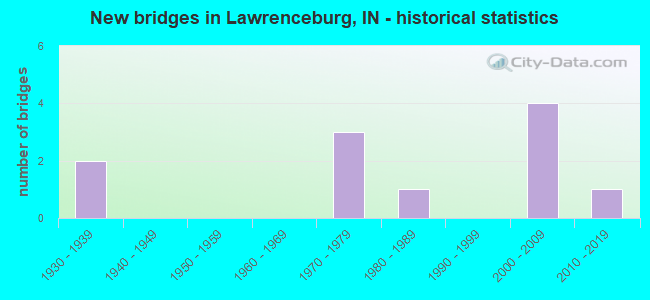
- New bridges - historical statistics
- 21930-1939
- 31970-1979
- 11980-1989
- 42000-2009
- 12010-2019


- Bridge Condition - Deck
- 40.0%Very good
- 40.0%Good
- 20.0%Satisfactory

- Bridge Condition - Superstructure
- 40.0%Very good
- 20.0%Good
- 20.0%Satisfactory
- 20.0%Fair

- Bridge Condition - Substructure
- 40.0%Very good
- 20.0%Good
- 20.0%Satisfactory
- 20.0%Fair

- Bridge Condition - Channel
- 33.3%Very good
- 16.7%Good
- 33.3%Satisfactory
- 16.7%Fair
Find on map >> Show street view
Structure Number: 1879, Location: 00.08 E SR 48 (Lat: 39.095289, Lng: -84.861739), Route carried "on" structure: US 50, Year Built: 1938, Year Reconstructed: 2016, Status: Open, Structure Length: 15.00m (49.21ft), Average Daily Traffic: 40,650 (year 2010), Truck Traffic: 8%, Average Future Daily Traffic: 54,750 (year 2030), Design Load: HS 20, Features Intersected: TANNERS CR & SERVICE RD
Minimum Vertical Clearance: 30+ m (98+ ft), Kilometerpoint: 26.876, Lanes on structure: 4, Lanes under structure: 2, Base Highway Network: Yes (, Subroute: 1), Owner: State Highway Agency, Approaching Roadway Width: 15.2m (49.9ft), Skew: 2 degrees, Material/Design: Prestressed concrete continuous, Design/Construction: Tee Beam, Number Of Spans In Main Unit: 5, Length of Maximum Span: 34.7m (113.8ft), Curb or Sidewalk Widths: Left: 4.2m (13.8ft), Right: 0.0m, Curb-To-Curb Width: 17.1m (56.1ft), Out-to-Out Width: 22.0m (72.2ft)
Condition: Deck: Very good, Superstructure: Very good, Substructure: Good, Channel: Satisfactory, Operating Rating: 34.7 metric tons, Method Used To Determine Operating Rating: Load and Resistance Factor Rating (LRFR) rating reported by rating factor(RF) method using HL-93 loadings, Inventory Rating: 26.9 metric tons, Method Used To Determine Inventory Rating: Load and Resistance Factor Rating (LRFR) rating reported by rating factor(RF) method using HL-93 loadings, Structural Evaluation: Equal to present minimum criteria, Deck Geometry: Somewhat better than minimum adequacy, Underclear: High priority of corrective action, Waterway Adequacy: Better than present minimum criteria, Approach Roadway Alignment: Equal to present desirable criteria, Designated Inspection Frequency: Every 24 months, Underwater Inspection Frequency: Every 60 months, Inspection Date: August 2021, Underwater Inspection Date: June 2021, Deck Structure Type: Concrete Cast-file-Place, Wearing Surface/Protective System: Wearing Surface: Monolithic Concrete, Deck Protection: Epoxy Coated Reinforcing
Find on map >> Show street view
Structure Number: 4966, Location: 00.00 OHIO RIVER (Lat: 39.104169, Lng: -84.825831), Route carried "on" structure: Interstate 275, Year Built: 1976, Status: Open, Structure Length: 123.49m (405.15ft), Average Daily Traffic: 40,222 (year 2017), Truck Traffic: 15%, Average Future Daily Traffic: 53,136 (year 2034), Design Load: HS 20+Mod, Features Intersected: OHIO RIVER, CSX RR, CR
Minimum Vertical Clearance: 30+ m (98+ ft), Kilometerpoint: 0.016, Lanes on structure: 4, Base Highway Network: Yes (, Subroute: 1), Owner: State Highway Agency, Approaching Roadway Width: 9.1m (29.9ft), Skew: 10 degrees, Navigation Control: Yes ( Vertical Clearance: 27.7m (90.9ft), Horizontal Clearance: 228.6m (750.0ft)), Material/Design: Steel continuous, Design/Construction: Truss - Thru, Number Of Spans In Main Unit: 3, Number Of Approach Spans: 12, Length of Maximum Span: 228.6m (750.0ft), Curb or Sidewalk Widths: Left: 0.5m (1.6ft), Right: 0.5m (1.6ft), Curb-To-Curb Width: 19.0m (62.3ft), Out-to-Out Width: 20.1m (65.9ft)
Condition: Deck: Good, Superstructure: Fair, Substructure: Fair, Channel: Good, Operating Rating: 48.7 metric tons, Method Used To Determine Operating Rating: Load Factor (LF), Inventory Rating: 29.4 metric tons, Method Used To Determine Inventory Rating: Load Factor (LF), Structural Evaluation: Somewhat better than minimum adequacy, Deck Geometry: Meets minimum limits, Waterway Adequacy: Superior to present desirable criteria, Approach Roadway Alignment: Equal to present desirable criteria, Designated Inspection Frequency: Every 24 months, Critical Feature Inspection Frequency: Every 24 months, Underwater Inspection Frequency: Every 60 months, Inspection Date: October 2020, Critical Feature Inspection Date: October 2020, Underwater Inspection Date: September 2017, Deck Structure Type: Concrete Cast-file-Place, Wearing Surface/Protective System: Wearing Surface: Latex Concrete, Deck Protection: Epoxy Coated Reinforcing
Find on map >> Show street view
Structure Number: 80008, Location: 02.97 E SR 148 (Lat: 39.095561, Lng: -84.861689), Route carried "on" structure: US 50, Year Built: 2009, Status: Open, Structure Length: 26.86m (88.12ft), Average Daily Traffic: 31,750 (year 2011), Truck Traffic: 8%, Average Future Daily Traffic: 35,431 (year 2033), Design Load: HL 93, Features Intersected: TANNERS CR, STREETS, RR
Minimum Vertical Clearance: 30+ m (98+ ft), Kilometerpoint: 26.876, Lanes on structure: 3, Lanes under structure: 2, Base Highway Network: Yes (, Subroute: 1), Owner: State Highway Agency, Approaching Roadway Width: 16.4m (53.8ft), Skew: 1 degrees, Material/Design: Steel continuous, Design/Construction: Stringer/Multi-beam, Number Of Spans In Main Unit: 4, Number Of Approach Spans: 2, Length of Maximum Span: 64.0m (210.0ft), Curb-To-Curb Width: 14.0m (45.9ft), Out-to-Out Width: 14.9m (48.9ft)
Condition: Deck: Good, Superstructure: Good, Substructure: Very good, Channel: Very good, Operating Rating: 32.4 metric tons, Method Used To Determine Operating Rating: Load and Resistance Factor Rating (LRFR) rating reported by rating factor(RF) method using HL-93 loadings, Inventory Rating: 26.9 metric tons, Method Used To Determine Inventory Rating: Load and Resistance Factor Rating (LRFR) rating reported by rating factor(RF) method using HL-93 loadings, Structural Evaluation: Equal to present minimum criteria, Deck Geometry: Somewhat better than minimum adequacy, Underclear: Equal to present minimum criteria, Waterway Adequacy: Superior to present desirable criteria, Approach Roadway Alignment: Equal to present desirable criteria, Designated Inspection Frequency: Every 24 months, Underwater Inspection Frequency: Every 60 months, Inspection Date: August 2021, Underwater Inspection Date: June 2021, Deck Structure Type: Concrete Cast-file-Place, Wearing Surface/Protective System: Wearing Surface: Epoxy Overlay, Deck Protection: Epoxy Coated Reinforcing
Find on map >> Show street view
Structure Number: 1500053, Location: 01.10 N OF US 50 (Lat: 39.089111, Lng: -84.902169), Route carried "on" structure: County highway , Year Built: 1984, Status: Open, Structure Length: 4.88m (16.01ft), Average Daily Traffic: 4,030 (year 2017), Truck Traffic: 5%, Average Future Daily Traffic: 5,980 (year 2037), Design Load: HS 20, Features Intersected: WILSON CREEK, Facility Carried by Structure: WILSON CREEK RD
Minimum Vertical Clearance: 30+ m (98+ ft), Kilometerpoint: 0.000, Lanes on structure: 2, Owner: County Highway Agency, Approaching Roadway Width: 6.4m (21.0ft), Skew: 6 degrees, Material/Design: Concrete continuous, Design/Construction: Slab, Number Of Spans In Main Unit: 5, Length of Maximum Span: 11.0m (36.1ft), Curb-To-Curb Width: 8.5m (27.9ft), Out-to-Out Width: 9.3m (30.5ft)
Condition: Deck: Satisfactory, Superstructure: Satisfactory, Substructure: Satisfactory, Channel: Satisfactory, Operating Rating: 55.2 metric tons, Method Used To Determine Operating Rating: Load Factor (LF), Inventory Rating: 33.0 metric tons, Method Used To Determine Inventory Rating: Load Factor (LF), Structural Evaluation: Equal to present minimum criteria, Deck Geometry: Meets minimum limits, Waterway Adequacy: Equal to present minimum criteria, Approach Roadway Alignment: Equal to present desirable criteria, Designated Inspection Frequency: Every 24 months, Inspection Date: April 2021, Deck Structure Type: Concrete Cast-file-Place, Wearing Surface/Protective System: Wearing Surface: Monolithic Concrete
Find on map >> Show street view
Structure Number: 1500092, Location: 00.20 N OF WILSON CREEK (Lat: 39.102111, Lng: -84.901419), Route carried "on" structure: County highway , Year Built: 1978, Status: Open, Structure Length: 0.91m (2.99ft), Average Daily Traffic: 4,200 (year 2017), Truck Traffic: 5%, Average Future Daily Traffic: 6,230 (year 2037), Features Intersected: WILSON CREEK, Facility Carried by Structure: WILSON CREEK RD
Minimum Vertical Clearance: 30+ m (98+ ft), Kilometerpoint: 0.000, Lanes on structure: 2, Owner: County Highway Agency, Approaching Roadway Width: 6.4m (21.0ft), Skew: 3 degrees, Material/Design: Steel, Design/Construction: Culvert, Number Of Spans In Main Unit: 1, Length of Maximum Span: 9.1m (29.9ft), Curb-To-Curb Width: 6.4m (21.0ft), Out-to-Out Width: 6.4m (21.0ft)
Condition: Channel: Fair, Culverts: Satisfactory, Operating Rating: 32.7 metric tons, Method Used To Determine Operating Rating: Field evaluation and documented engineering judgment, Inventory Rating: 32.7 metric tons, Method Used To Determine Inventory Rating: Field evaluation and documented engineering judgment, Structural Evaluation: Equal to present minimum criteria, Deck Geometry: High priority of replacement, Waterway Adequacy: Equal to present minimum criteria, Approach Roadway Alignment: Equal to present desirable criteria, Designated Inspection Frequency: Every 24 months, Inspection Date: April 2021
Find on map >> Show street view
Structure Number: 150012, Location: 00.40 NW PRIBBLE RD (Lat: 39.156011, Lng: -84.902939), Route carried "on" structure: County highway , Year Built: 2016, Status: Open, Structure Length: 1.28m (4.20ft), Average Daily Traffic: 1,640 (year 2017), Truck Traffic: 10%, Average Future Daily Traffic: 2,430 (year 2037), Design Load: HS 20, Features Intersected: BRANCH TANNERS CREEK, Facility Carried by Structure: KAISER DR
Minimum Vertical Clearance: 30+ m (98+ ft), Kilometerpoint: 0.000, Lanes on structure: 2, Owner: County Highway Agency, Approaching Roadway Width: 6.4m (21.0ft), Material/Design: Prestressed concrete, Design/Construction: Box Beam or Girders - Multiple, Number Of Spans In Main Unit: 1, Length of Maximum Span: 12.5m (41.0ft), Curb-To-Curb Width: 8.7m (28.5ft), Out-to-Out Width: 8.8m (28.9ft)
Condition: Deck: Very good, Superstructure: Very good, Substructure: Very good, Channel: Very good, Operating Rating: 77.4 metric tons, Method Used To Determine Operating Rating: Load Factor (LF), Inventory Rating: 43.3 metric tons, Method Used To Determine Inventory Rating: Load Factor (LF), Structural Evaluation: Equal to present desirable criteria, Deck Geometry: Somewhat better than minimum adequacy, Waterway Adequacy: Better than present minimum criteria, Approach Roadway Alignment: High priority of corrective action, Designated Inspection Frequency: Every 24 months, Inspection Date: April 2021, Deck Structure Type: Concrete Cast-file-Place, Wearing Surface/Protective System: Wearing Surface: Monolithic Concrete, Membrane: Epoxy, Deck Protection: Epoxy Coated Reinforcing
Find on map >> Show street view
Structure Number: 1879, Location: 00.08 E SR-48 (Lat: 39.095289, Lng: -84.861739), Route carried "under" structure: ServiceOther road , Year Built: 1938, Structure Length: 0. m, Average Daily Traffic: 132 (year 2004), Truck Traffic: 10%, Features Intersected: SERVICE RD, Facility Carried by Structure: US 50 EB
Minimum Vertical Clearance: 5.56m (18.24ft), Kilometerpoint: 0.000, Lanes on structure: 4, Lanes under structure: 2, Material/Design: Steel continuous, Design/Construction: Stringer/Multi-beam, Length of Maximum Span: 34.7m (113.8ft)
Find on map >> Show street view
Structure Number: 4966, Location: 00.00 OHIO RIVER (Lat: 39.104900, Lng: -84.826758), Route carried "under" structure: ServiceOther road , Year Built: 1976, Structure Length: 0. m, Average Daily Traffic: 10 (year 2014), Features Intersected: ACCESS RD, Facility Carried by Structure: I-275
Minimum Vertical Clearance: 7.47m (24.51ft), Kilometerpoint: 0.000, Lanes on structure: 4, Lanes under structure: 2, Material/Design: Steel continuous, Design/Construction: Arch - Thru, Length of Maximum Span: 228.6m (750.0ft)
Find on map >> Show street view
Structure Number: 80008, Location: 02.97 E SR-148 (Lat: 39.095561, Lng: -84.861694), Route carried "under" structure: ServiceCity street , Year Built: 2009, Structure Length: 0. m, Average Daily Traffic: 132 (year 2008), Truck Traffic: 10%, Features Intersected: SERVICE RD, Facility Carried by Structure: US 50 WB
Minimum Vertical Clearance: 12.19m (39.99ft), Kilometerpoint: 0.000, Lanes on structure: 3, Lanes under structure: 2, Material/Design: Steel continuous, Design/Construction: Stringer/Multi-beam, Length of Maximum Span: 64.0m (210.0ft)
Find on map >> Show street view
Structure Number: 80008, Location: 02.97 E SR-148 (Lat: 39.095561, Lng: -84.861694), Route carried "under" structure: ServiceOther road , Year Built: 2009, Structure Length: 0. m, Average Daily Traffic: 132 (year 2004), Truck Traffic: 10%, Features Intersected: SERVICE RD, Facility Carried by Structure: US 50 WB
Minimum Vertical Clearance: 9.75m (31.99ft), Kilometerpoint: 0.000, Lanes on structure: 3, Lanes under structure: 2, Material/Design: Steel continuous, Design/Construction: Stringer/Multi-beam, Length of Maximum Span: 64.0m (210.0ft)
Find on map >> Show street view
Structure Number: 80008, Location: 02.97 E SR-148 (Lat: 39.095561, Lng: -84.861694), Route carried "under" structure: City street , Year Built: 2009, Structure Length: 0. m, Average Daily Traffic: 3,320 (year 2011), Truck Traffic: 10%, Features Intersected: SHIPPING STREET, Facility Carried by Structure: US 50 WB
Minimum Vertical Clearance: 5.87m (19.26ft), Kilometerpoint: 0.000, Lanes on structure: 3, Lanes under structure: 2, Material/Design: Steel continuous, Design/Construction: Stringer/Multi-beam, Length of Maximum Span: 64.0m (210.0ft)