Bridge Statistics for Leisuretowne, New Jersey (NJ)
Condition, Traffic, Stress, Structural Evaluation, Project Costs
- National Bridge Inventory (NBI) Statistics
- 16Number of bridges
- 66ft / 20.1mTotal length
- $2,576,000Total costs
- 74,582Total average daily traffic
- 2,649Total average daily truck traffic
- 93,321Total future (year 2039) average daily traffic
- National Bridge Inventory (NBI) Registered Bridges for Leisuretowne
- No street view available for this location
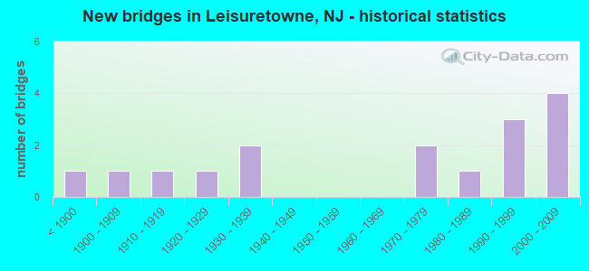
- New bridges - historical statistics
- 1Before 1900
- 11900-1909
- 11910-1919
- 11920-1929
- 21930-1939
- 21970-1979
- 11980-1989
- 31990-1999
- 42000-2009

- Reconstructed bridges - Historical Statistics
- 11970-1979
- 01980-1989
- 01990-1999
- 22000-2009
- 12010-2019


- Bridge Condition - Deck
- 12.5%Very good
- 43.8%Good
- 25.0%Satisfactory
- 18.8%Fair

- Bridge Condition - Superstructure
- 25.0%Very good
- 43.8%Good
- 18.8%Satisfactory
- 12.5%Fair

- Bridge Condition - Substructure
- 12.5%Very good
- 43.8%Good
- 18.8%Satisfactory
- 18.8%Fair
- 6.3%Imminent failure

- Bridge Condition - Channel
- 6.3%Very good
- 37.5%Good
- 43.8%Satisfactory
- 12.5%Fair
Find on map >> Show street view
Structure Number: 310154, Location: 1.9 MI. E. OF 206 1NT (Lat: 39.885850, Lng: -74.707119), Route carried "on" structure: State highway 70, Year Built: 2004, Status: Open, Structure Length: 1.74m (5.71ft), Average Daily Traffic: 15,779 (year 2021), Truck Traffic: 4%, Average Future Daily Traffic: 22,560 (year 2041), Design Load: HS 25 or greater, Features Intersected: FRIENDSHIP CREEK
Minimum Vertical Clearance: 30+ m (98+ ft), Kilometerpoint: 32.815, Lanes on structure: 2, Base Highway Network: Yes, Owner: State Highway Agency, Approaching Roadway Width: 17.1m (56.1ft), Material/Design: Prestressed concrete, Design/Construction: Box Beam or Girders - Multiple, Number Of Spans In Main Unit: 1, Length of Maximum Span: 15.8m (51.8ft), Curb-To-Curb Width: 17.2m (56.4ft), Out-to-Out Width: 18.6m (61.0ft)
Condition: Deck: Good, Superstructure: Good, Substructure: Good, Channel: Very good, Operating Rating: 78.9 metric tons, Method Used To Determine Operating Rating: Load Factor (LF), Inventory Rating: 47.2 metric tons, Method Used To Determine Inventory Rating: Load Factor (LF), Structural Evaluation: Better than present minimum criteria, Deck Geometry: Superior to present desirable criteria, Waterway Adequacy: Superior to present desirable criteria, Approach Roadway Alignment: Equal to present desirable criteria, Designated Inspection Frequency: Every 24 months, Inspection Date: May 2021, Deck Structure Type: Concrete Precast Panels, Wearing Surface/Protective System: Wearing Surface: Latex Concrete
Find on map >> Show street view
Structure Number: 324155, Location: .1 MILE SO OF VINCETOWNRD (Lat: 39.929481, Lng: -74.742319), Route carried "on" structure: US 206, Year Built: 1930, Status: Open, Structure Length: 1.71m (5.61ft), Average Daily Traffic: 19,912 (year 2021), Truck Traffic: 4%, Average Future Daily Traffic: 23,895 (year 2041), Design Load: H 20, Features Intersected: S BR RANCOCAS CREEK
Minimum Vertical Clearance: 30+ m (98+ ft), Kilometerpoint: 33.169, Lanes on structure: 2, Base Highway Network: Yes, Owner: State Highway Agency, Approaching Roadway Width: 12.2m (40.0ft), Material/Design: Steel, Design/Construction: Stringer/Multi-beam, Number Of Spans In Main Unit: 1, Length of Maximum Span: 15.8m (51.8ft), Curb or Sidewalk Widths: Left: 0.2m (0.7ft), Right: 0.2m (0.7ft), Curb-To-Curb Width: 12.5m (41.0ft), Out-to-Out Width: 13.4m (44.0ft)
Condition: Deck: Fair, Superstructure: Fair, Substructure: Fair, Channel: Satisfactory, Operating Rating: 86.2 metric tons, Method Used To Determine Operating Rating: Load Factor (LF), Inventory Rating: 51.7 metric tons, Method Used To Determine Inventory Rating: Load Factor (LF), Structural Evaluation: Somewhat better than minimum adequacy, Deck Geometry: Somewhat better than minimum adequacy, Waterway Adequacy: Equal to present desirable criteria, Approach Roadway Alignment: Equal to present desirable criteria, Length Of Structure Improvement: 0.91m (2.99ft), Designated Inspection Frequency: Every 24 months, Underwater Inspection Frequency: Every 24 months, Inspection Date: August 2021, Underwater Inspection Date: May 2021, Bridge Improvement Cost: $240,000, Total Project Cost: $325,000 ( Estimate for 2021), Deck Structure Type: Concrete Cast-file-Place, Wearing Surface/Protective System: Wearing Surface: Bituminous
Find on map >> Show street view
Structure Number: 324156, Location: 0.22 MI N OF CR 642 (Lat: 39.936339, Lng: -74.743019), Route carried "on" structure: US 206, Year Built: 1930, Status: Open, Structure Length: 0.67m (2.20ft), Average Daily Traffic: 14,535 (year 2021), Truck Traffic: 4%, Average Future Daily Traffic: 17,442 (year 2041), Design Load: HS 20, Features Intersected: JADE RUN
Minimum Vertical Clearance: 30+ m (98+ ft), Kilometerpoint: 33.925, Lanes on structure: 2, Base Highway Network: Yes, Owner: State Highway Agency, Approaching Roadway Width: 12.2m (40.0ft), Material/Design: Concrete, Design/Construction: Slab, Number Of Spans In Main Unit: 1, Length of Maximum Span: 6.1m (20.0ft), Curb-To-Curb Width: 12.6m (41.3ft), Out-to-Out Width: 13.4m (44.0ft)
Condition: Deck: Satisfactory, Superstructure: Satisfactory, Substructure: Satisfactory, Channel: Satisfactory, Operating Rating: 66.2 metric tons, Method Used To Determine Operating Rating: Load Factor (LF), Inventory Rating: 39.9 metric tons, Method Used To Determine Inventory Rating: Load Factor (LF), Structural Evaluation: Equal to present minimum criteria, Deck Geometry: Somewhat better than minimum adequacy, Waterway Adequacy: Superior to present desirable criteria, Approach Roadway Alignment: Equal to present desirable criteria, Length Of Structure Improvement: 0.67m (2.20ft), Designated Inspection Frequency: Every 24 months, Underwater Inspection Frequency: Every 24 months, Inspection Date: March 2021, Underwater Inspection Date: March 2021, Deck Structure Type: Concrete Cast-file-Place, Wearing Surface/Protective System: Wearing Surface: Bituminous
Find on map >> Show street view
Structure Number: 3D426, Location: 0.1Mi N of CR 616&681 JCT (Lat: 39.938519, Lng: -74.751069), Route carried "on" structure: County highway 681, Year Built: 1995, Status: Open, Structure Length: 1.19m (3.90ft), Average Daily Traffic: 2,648 (year 2021), Truck Traffic: 3%, Average Future Daily Traffic: 3,178 (year 2041), Design Load: HS 25 or greater, Features Intersected: STOP THE JADE RUN
Minimum Vertical Clearance: 30+ m (98+ ft), Kilometerpoint: 1.690, Lanes on structure: 2, Owner: County Highway Agency, Approaching Roadway Width: 9.1m (29.9ft), Material/Design: Prestressed concrete, Design/Construction: Box Beam or Girders - Multiple, Number Of Spans In Main Unit: 1, Length of Maximum Span: 10.4m (34.1ft), Curb or Sidewalk Widths: Left: 1.8m (5.9ft), Right: 0.2m (0.7ft), Curb-To-Curb Width: 9.1m (29.9ft), Out-to-Out Width: 12.1m (39.7ft)
Condition: Deck: Satisfactory, Superstructure: Good, Substructure: Good, Channel: Satisfactory, Inventory Rating: 72.6 metric tons, Method Used To Determine Inventory Rating: Load Factor (LF), Structural Evaluation: Better than present minimum criteria, Deck Geometry: Meets minimum limits, Waterway Adequacy: Equal to present minimum criteria, Approach Roadway Alignment: Equal to present minimum criteria, Length Of Structure Improvement: 1.19m (3.90ft), Designated Inspection Frequency: Every 24 months, Inspection Date: September 2021, Deck Structure Type: Concrete Cast-file-Place, Wearing Surface/Protective System: Wearing Surface: Monolithic Concrete, Deck Protection: Epoxy Coated Reinforcing
Find on map >> Show street view
Structure Number: 3D427, Location: 0.1 MI W OF CR 641&616JCT (Lat: 39.937039, Lng: -74.752339), Route carried "on" structure: County highway 616, Year Built: 1918, Status: Open, Structure Length: 1.16m (3.81ft), Average Daily Traffic: 7,192 (year 2021), Truck Traffic: 3%, Average Future Daily Traffic: 8,630 (year 2041), Features Intersected: SO.BR RANCOCAS CREEK
Minimum Vertical Clearance: 30+ m (98+ ft), Kilometerpoint: 20.728, Lanes on structure: 2, Owner: County Highway Agency, Approaching Roadway Width: 9.1m (29.9ft), Material/Design: Steel, Design/Construction: Stringer/Multi-beam, Number Of Spans In Main Unit: 1, Length of Maximum Span: 11.6m (38.1ft), Curb or Sidewalk Widths: Left: 1.8m (5.9ft), Right: 1.8m (5.9ft), Curb-To-Curb Width: 9.1m (29.9ft), Out-to-Out Width: 13.5m (44.3ft)
Condition: Deck: Fair, Superstructure: Fair, Substructure: Fair, Channel: Satisfactory, Inventory Rating: 54.4 metric tons, Method Used To Determine Inventory Rating: Load Factor (LF), Structural Evaluation: Somewhat better than minimum adequacy, Deck Geometry: High priority of corrective action, Waterway Adequacy: Better than present minimum criteria, Approach Roadway Alignment: Better than present minimum criteria, Length Of Structure Improvement: 1.16m (3.81ft), Designated Inspection Frequency: Every 24 months, Inspection Date: September 2021, Bridge Improvement Cost: $57,000, Roadway Improvement Cost: $9,000, Total Project Cost: $370,000 ( Estimate for 2021), Deck Structure Type: Concrete Cast-file-Place, Wearing Surface/Protective System: Wearing Surface: Bituminous
Find on map >> Show street view
Structure Number: 3D43, Location: 0.5 MI. WEST OF US 206 (Lat: 39.935300, Lng: -74.751550), Route carried "on" structure: City street , Year Built: 2005, Status: Open, Structure Length: 1.16m (3.81ft), Average Daily Traffic: 705 (year 2020), Truck Traffic: 1%, Average Future Daily Traffic: 860 (year 2040), Design Load: HL 93, Features Intersected: SO BR OF RANCOCAS CREEK, Facility Carried by Structure: RACE STREET
Minimum Vertical Clearance: 30+ m (98+ ft), Kilometerpoint: 0.000, Lanes on structure: 2, Owner: County Highway Agency, Approaching Roadway Width: 6.1m (20.0ft), Material/Design: Prestressed concrete, Design/Construction: Slab, Number Of Spans In Main Unit: 1, Length of Maximum Span: 10.1m (33.1ft), Curb or Sidewalk Widths: Left: 0.2m (0.7ft), Right: 1.8m (5.9ft), Curb-To-Curb Width: 9.0m (29.5ft), Out-to-Out Width: 12.4m (40.7ft)
Condition: Deck: Good, Superstructure: Very good, Substructure: Good, Channel: Satisfactory, Operating Rating: 67.7 metric tons, Method Used To Determine Operating Rating: Load and Resistance Factor Rating (LRFR) rating reported by rating factor(RF) method using HL-93 loadings, Inventory Rating: 52.5 metric tons, Method Used To Determine Inventory Rating: Load and Resistance Factor Rating (LRFR) rating reported by rating factor(RF) method using HL-93 loadings, Structural Evaluation: Better than present minimum criteria, Deck Geometry: Somewhat better than minimum adequacy, Waterway Adequacy: Superior to present desirable criteria, Approach Roadway Alignment: Better than present minimum criteria, Designated Inspection Frequency: Every 24 months, Inspection Date: September 2020, Deck Structure Type: Concrete Cast-file-Place, Wearing Surface/Protective System: Wearing Surface: Monolithic Concrete, Deck Protection: Epoxy Coated Reinforcing
Find on map >> Show street view
Structure Number: 3D441, Location: 0.6 MI WEST OF VINCENTOWN (Lat: 39.940128, Lng: -74.763175), Route carried "on" structure: County highway 641, Year Built: 2001, Status: Open, Structure Length: 2.50m (8.20ft), Average Daily Traffic: 2,230 (year 2020), Truck Traffic: 1%, Average Future Daily Traffic: 2,720 (year 2040), Design Load: HS 20, Features Intersected: SOUTH BR. RANCOCAS CREEK, Facility Carried by Structure: LANDING CR 64
Minimum Vertical Clearance: 30+ m (98+ ft), Kilometerpoint: 6.904, Lanes on structure: 2, Owner: County Highway Agency, Approaching Roadway Width: 7.6m (24.9ft), Material/Design: Prestressed concrete, Design/Construction: Box Beam or Girders - Multiple, Number Of Spans In Main Unit: 1, Length of Maximum Span: 25.0m (82.0ft), Curb-To-Curb Width: 11.1m (36.4ft), Out-to-Out Width: 12.3m (40.4ft)
Condition: Deck: Good, Superstructure: Very good, Substructure: Very good, Channel: Fair, Inventory Rating: 61.7 metric tons, Method Used To Determine Inventory Rating: Load Factor (LF), Structural Evaluation: Equal to present desirable criteria, Deck Geometry: Somewhat better than minimum adequacy, Waterway Adequacy: Equal to present desirable criteria, Approach Roadway Alignment: Equal to present desirable criteria, Designated Inspection Frequency: Every 24 months, Inspection Date: August 2020, Deck Structure Type: Concrete Cast-file-Place, Wearing Surface/Protective System: Wearing Surface: Monolithic Concrete, Deck Protection: Epoxy Coated Reinforcing
Find on map >> Show street view
Structure Number: 3E41, Location: 0.1 Mi. W. of Big Hill Rd (Lat: 39.916489, Lng: -74.714319), Route carried "on" structure: Other road , Year Built: 1900, Year Reconstructed: 2000, Status: Open, Structure Length: 0.85m (2.79ft), Average Daily Traffic: 2,090 (year 2020), Truck Traffic: 3%, Average Future Daily Traffic: 2,550 (year 2040), Features Intersected: FRIENDSHIP CREEK, Facility Carried by Structure: RETREAT ROAD
Minimum Vertical Clearance: 30+ m (98+ ft), Kilometerpoint: 0.064, Lanes on structure: 2, Owner: County Highway Agency, Approaching Roadway Width: 6.7m (22.0ft), Material/Design: Wood or Timber, Design/Construction: Slab, Number Of Spans In Main Unit: 2, Length of Maximum Span: 4.3m (14.1ft), Curb-To-Curb Width: 7.1m (23.3ft), Out-to-Out Width: 7.7m (25.3ft)
Condition: Deck: Satisfactory, Superstructure: Satisfactory, Substructure: Fair, Channel: Good, Operating Rating: 88.0 metric tons, Method Used To Determine Operating Rating: Allowable Stress (AS), Inventory Rating: 65.3 metric tons, Method Used To Determine Inventory Rating: Allowable Stress (AS), Structural Evaluation: Somewhat better than minimum adequacy, Deck Geometry: High priority of replacement, Waterway Adequacy: Better than present minimum criteria, Approach Roadway Alignment: Equal to present minimum criteria, Length Of Structure Improvement: 0.85m (2.79ft), Designated Inspection Frequency: Every 24 months, Inspection Date: September 2020, Bridge Improvement Cost: $20,000, Roadway Improvement Cost: $24,000, Total Project Cost: $182,000 ( Estimate for 2020), Deck Structure Type: Wood or Timber, Wearing Surface/Protective System: Wearing Surface: Bituminous
Find on map >> Show street view
Structure Number: 3E412, Location: 350 Ft. N. of Retreat Rd. (Lat: 39.919711, Lng: -74.706461), Route carried "on" structure: Other road , Year Built: 1994, Status: Open, Structure Length: 1.25m (4.10ft), Average Daily Traffic: 45 (year 2020), Truck Traffic: 1%, Average Future Daily Traffic: 55 (year 2040), Features Intersected: SO-BRANCH RANCOCAS CREEK, Facility Carried by Structure: BED BUG HILL ROAD
Minimum Vertical Clearance: 30+ m (98+ ft), Kilometerpoint: 0.000, Lanes on structure: 2, Owner: County Highway Agency, Approaching Roadway Width: 5.8m (19.0ft), Material/Design: Wood or Timber, Design/Construction: Slab, Number Of Spans In Main Unit: 2, Length of Maximum Span: 6.4m (21.0ft), Curb-To-Curb Width: 7.0m (23.0ft), Out-to-Out Width: 7.5m (24.6ft)
Condition: Deck: Good, Superstructure: Good, Substructure: Good, Channel: Good, Operating Rating: 53.5 metric tons, Method Used To Determine Operating Rating: Allowable Stress (AS), Inventory Rating: 39.0 metric tons, Method Used To Determine Inventory Rating: Allowable Stress (AS), Structural Evaluation: Better than present minimum criteria, Deck Geometry: Somewhat better than minimum adequacy, Waterway Adequacy: Equal to present minimum criteria, Approach Roadway Alignment: Equal to present desirable criteria, Designated Inspection Frequency: Every 24 months, Underwater Inspection Frequency: Every 48 months, Inspection Date: September 2020, Underwater Inspection Date: August 2018, Deck Structure Type: Wood or Timber, Wearing Surface/Protective System: Wearing Surface: Bituminous
Find on map >> Show street view
Structure Number: 3E422, Location: 600 Ft. S of Pemberton Rd (Lat: 39.942450, Lng: -74.716211), Route carried "on" structure: City street , Year Built: 1926, Year Reconstructed: 1976, Status: Closed, Structure Length: 0.73m (2.40ft), Average Daily Traffic: 50 (year 2020), Truck Traffic: 3%, Average Future Daily Traffic: 60 (year 2040), Features Intersected: STOP THE JADE RUN, Facility Carried by Structure: BRACE ROAD
Minimum Vertical Clearance: 30+ m (98+ ft), Kilometerpoint: 0.000, Lanes on structure: 1, Owner: County Highway Agency, Approaching Roadway Width: 4.1m (13.5ft), Material/Design: Wood or Timber, Design/Construction: Stringer/Multi-beam, Number Of Spans In Main Unit: 2, Length of Maximum Span: 3.4m (11.2ft), Curb-To-Curb Width: 4.1m (13.5ft), Out-to-Out Width: 4.3m (14.1ft)
Condition: Deck: Good, Superstructure: Good, Substructure: Imminent failure, Channel: Fair, Operating Rating: 18.1 metric tons, Method Used To Determine Operating Rating: Allowable Stress (AS), Inventory Rating: 12.7 metric tons, Method Used To Determine Inventory Rating: Allowable Stress (AS), Deck Geometry: Somewhat better than minimum adequacy, Waterway Adequacy: Equal to present desirable criteria, Approach Roadway Alignment: Equal to present desirable criteria, Bridge Posting: Required (Relationship of Operating Rating to Maximum Legal Load: > 39.9% below), Length Of Structure Improvement: 1.25m (4.10ft), Designated Inspection Frequency: Every 24 months, Inspection Date: September 2020, Bridge Improvement Cost: $390,000, Roadway Improvement Cost: $50,000, Total Project Cost: $706,000 ( Estimate for 2020), Deck Structure Type: Wood or Timber
Find on map >> Show street view
Structure Number: 3E44, Location: 0.1 Mi. S. of Main St. (Lat: 39.929689, Lng: -74.743600), Route carried "on" structure: Other road , Year Built: 1893, Year Reconstructed: 2006, Status: Posted for load, Structure Length: 1.31m (4.30ft), Average Daily Traffic: 475 (year 2020), Truck Traffic: 1%, Average Future Daily Traffic: 580 (year 2040), Design Load: H 15, Features Intersected: SO BR RANCOCAS CREEK, Facility Carried by Structure: HILLIARDS BR RD
Minimum Vertical Clearance: 30+ m (98+ ft), Kilometerpoint: 0.000, Lanes on structure: 1, Owner: County Highway Agency, Approaching Roadway Width: 5.5m (18.0ft), Material/Design: Steel, Design/Construction: Truss - Thru, Number Of Spans In Main Unit: 1, Length of Maximum Span: 11.6m (38.1ft), Curb-To-Curb Width: 4.1m (13.5ft), Out-to-Out Width: 4.8m (15.7ft)
Condition: Deck: Satisfactory, Superstructure: Very good, Substructure: Very good, Channel: Good, Operating Rating: 80.7 metric tons, Method Used To Determine Operating Rating: Load Factor (LF), Inventory Rating: 57.2 metric tons, Method Used To Determine Inventory Rating: Load Factor (LF), Structural Evaluation: Equal to present desirable criteria, Deck Geometry: High priority of replacement, Waterway Adequacy: Better than present minimum criteria, Approach Roadway Alignment: Equal to present minimum criteria, Length Of Structure Improvement: 1.89m (6.20ft), Designated Inspection Frequency: Every 24 months, Critical Feature Inspection Frequency: Every 24 months, Underwater Inspection Frequency: Every 48 months, Inspection Date: September 2020, Critical Feature Inspection Date: September 2020, Underwater Inspection Date: August 2018, Bridge Improvement Cost: $590,000, Roadway Improvement Cost: $69,000, Total Project Cost: $993,000 ( Estimate for 2020), Deck Structure Type: Wood or Timber
Find on map >> Show street view
Structure Number: 3E46, Location: .32 Miles S OF NJ 206 (Lat: 39.929169, Lng: -74.737761), Route carried "on" structure: City street , Year Built: 2001, Status: Open, Structure Length: 1.68m (5.51ft), Average Daily Traffic: 1,882 (year 2021), Truck Traffic: 3%, Average Future Daily Traffic: 2,258 (year 2041), Design Load: HS 20, Features Intersected: SO.BRNCH RANCOCAS CK., Facility Carried by Structure: RETREAT RD
Minimum Vertical Clearance: 30+ m (98+ ft), Kilometerpoint: 2.655, Lanes on structure: 2, Owner: County Highway Agency, Approaching Roadway Width: 9.4m (30.8ft), Material/Design: Wood or Timber, Design/Construction: Slab, Number Of Spans In Main Unit: 3, Length of Maximum Span: 5.5m (18.0ft), Curb-To-Curb Width: 9.3m (30.5ft), Out-to-Out Width: 9.9m (32.5ft)
Condition: Deck: Good, Superstructure: Good, Substructure: Good, Channel: Good, Operating Rating: 73.5 metric tons, Method Used To Determine Operating Rating: Field evaluation and documented engineering judgment, Inventory Rating: 44.5 metric tons, Method Used To Determine Inventory Rating: Field evaluation and documented engineering judgment, Structural Evaluation: Better than present minimum criteria, Deck Geometry: Somewhat better than minimum adequacy, Waterway Adequacy: Superior to present desirable criteria, Approach Roadway Alignment: Equal to present desirable criteria, Designated Inspection Frequency: Every 24 months, Underwater Inspection Frequency: Every 48 months, Inspection Date: September 2021, Underwater Inspection Date: September 2021, Deck Structure Type: Wood or Timber, Wearing Surface/Protective System: Wearing Surface: Bituminous, Membrane: Preformed Fabric
Find on map >> Show street view
Structure Number: 3E49, Location: 1.69 MILES EAST OF RT.206 (Lat: 39.923189, Lng: -74.717611), Route carried "on" structure: Other road , Year Built: 1987, Status: Open, Structure Length: 1.37m (4.49ft), Average Daily Traffic: 2,049 (year 2019), Truck Traffic: 5%, Average Future Daily Traffic: 2,458 (year 2039), Design Load: HS 20+Mod, Features Intersected: SO BRANCH RANCOCAS CREEK, Facility Carried by Structure: RIDGE ROAD
Minimum Vertical Clearance: 30+ m (98+ ft), Kilometerpoint: 3.009, Lanes on structure: 2, Owner: County Highway Agency, Approaching Roadway Width: 8.5m (27.9ft), Material/Design: Wood or Timber, Design/Construction: Slab, Number Of Spans In Main Unit: 2, Length of Maximum Span: 6.4m (21.0ft), Curb-To-Curb Width: 8.5m (27.9ft), Out-to-Out Width: 8.9m (29.2ft)
Condition: Deck: Good, Superstructure: Good, Substructure: Good, Channel: Good, Operating Rating: 54.4 metric tons, Method Used To Determine Operating Rating: Field evaluation and documented engineering judgment, Inventory Rating: 32.7 metric tons, Method Used To Determine Inventory Rating: Field evaluation and documented engineering judgment, Structural Evaluation: Better than present minimum criteria, Deck Geometry: Meets minimum limits, Waterway Adequacy: Superior to present desirable criteria, Approach Roadway Alignment: Equal to present desirable criteria, Designated Inspection Frequency: Every 24 months, Inspection Date: October 2021, Deck Structure Type: Wood or Timber, Wearing Surface/Protective System: Wearing Surface: Bituminous
Find on map >> Show street view
Structure Number: 3E5083, Location: 0.15 M. S. of Foxchase Rd (Lat: 39.870989, Lng: -74.693072), Route carried "on" structure: Other road , Year Built: 1977, Status: Open, Structure Length: 1.01m (3.31ft), Average Daily Traffic: 1,690 (year 2020), Truck Traffic: 3%, Average Future Daily Traffic: 2,060 (year 2040), Design Load: HS 20, Features Intersected: FRIENDSHIP CREEK, Facility Carried by Structure: POWELL PLACE ROAD
Minimum Vertical Clearance: 30+ m (98+ ft), Kilometerpoint: 0.000, Lanes on structure: 2, Owner: County Highway Agency, Approaching Roadway Width: 8.5m (27.9ft), Skew: 1 degrees, Material/Design: Wood or Timber, Design/Construction: Stringer/Multi-beam, Number Of Spans In Main Unit: 2, Length of Maximum Span: 4.6m (15.1ft), Curb-To-Curb Width: 9.5m (31.2ft), Out-to-Out Width: 10.0m (32.8ft)
Condition: Deck: Fair, Superstructure: Good, Substructure: Satisfactory, Channel: Satisfactory, Operating Rating: 30.8 metric tons, Method Used To Determine Operating Rating: Allowable Stress (AS), Inventory Rating: 22.7 metric tons, Method Used To Determine Inventory Rating: Allowable Stress (AS), Structural Evaluation: Equal to present minimum criteria, Deck Geometry: Somewhat better than minimum adequacy, Waterway Adequacy: Equal to present desirable criteria, Approach Roadway Alignment: Equal to present desirable criteria, Designated Inspection Frequency: Every 24 months, Inspection Date: August 2020, Deck Structure Type: Wood or Timber, Wearing Surface/Protective System: Wearing Surface: Wood or Timber
Find on map >> Show street view
Structure Number: 3E561, Location: 0.15 M. N. of Powell Rd. (Lat: 39.881881, Lng: -74.675039), Route carried "on" structure: Other road , Year Built: 1994, Status: Open, Structure Length: 0.91m (2.99ft), Average Daily Traffic: 2,750 (year 2020), Truck Traffic: 1%, Average Future Daily Traffic: 3,355 (year 2040), Design Load: HS 20, Features Intersected: BURRS MILL BROOK, Facility Carried by Structure: SOOY PLACE ROAD
Minimum Vertical Clearance: 30+ m (98+ ft), Kilometerpoint: 0.000, Lanes on structure: 2, Owner: County Highway Agency, Approaching Roadway Width: 7.9m (25.9ft), Material/Design: Prestressed concrete, Design/Construction: Box Beam or Girders - Single/Spread, Number Of Spans In Main Unit: 1, Length of Maximum Span: 7.9m (25.9ft), Curb-To-Curb Width: 8.5m (27.9ft), Out-to-Out Width: 9.6m (31.5ft)
Condition: Deck: Very good, Superstructure: Very good, Substructure: Good, Channel: Good, Operating Rating: 66.2 metric tons, Method Used To Determine Operating Rating: Load Factor (LF), Inventory Rating: 39.0 metric tons, Method Used To Determine Inventory Rating: Load Factor (LF), Structural Evaluation: Better than present minimum criteria, Deck Geometry: Meets minimum limits, Waterway Adequacy: Equal to present desirable criteria, Approach Roadway Alignment: Equal to present desirable criteria, Designated Inspection Frequency: Every 24 months, Underwater Inspection Frequency: Every 48 months, Inspection Date: September 2020, Underwater Inspection Date: October 2020, Deck Structure Type: Concrete Cast-file-Place, Wearing Surface/Protective System: Wearing Surface: Monolithic Concrete, Deck Protection: Epoxy Coated Reinforcing
Find on map >> Show street view
Structure Number: 3F5015, Location: .2 MI S OF NJ RTE 70 (Lat: 39.886081, Lng: -74.657200), Route carried "on" structure: Other road , Year Built: 1975, Year Reconstructed: 2019, Status: Open, Structure Length: 0.85m (2.79ft), Average Daily Traffic: 550 (year 2021), Truck Traffic: 3%, Average Future Daily Traffic: 660 (year 2041), Features Intersected: BURRS MILL BROOK, Facility Carried by Structure: BURRS MILL ROAD
Minimum Vertical Clearance: 30+ m (98+ ft), Kilometerpoint: 0.000, Lanes on structure: 2, Owner: County Highway Agency, Approaching Roadway Width: 6.1m (20.0ft), Material/Design: Wood or Timber, Design/Construction: Stringer/Multi-beam, Number Of Spans In Main Unit: 2, Length of Maximum Span: 4.3m (14.1ft), Curb-To-Curb Width: 6.9m (22.6ft), Out-to-Out Width: 7.3m (24.0ft)
Condition: Deck: Very good, Superstructure: Satisfactory, Substructure: Satisfactory, Channel: Satisfactory, Operating Rating: 54.4 metric tons, Method Used To Determine Operating Rating: Field evaluation and documented engineering judgment, Inventory Rating: 32.7 metric tons, Method Used To Determine Inventory Rating: Field evaluation and documented engineering judgment, Structural Evaluation: Equal to present minimum criteria, Deck Geometry: Meets minimum limits, Waterway Adequacy: Better than present minimum criteria, Approach Roadway Alignment: Equal to present desirable criteria, Designated Inspection Frequency: Every 24 months, Underwater Inspection Frequency: Every 48 months, Inspection Date: September 2021, Underwater Inspection Date: September 2021, Deck Structure Type: Wood or Timber